Integration between TLS and UAV photogrammetry techniques for forestry applications
Irene Aicardi, Paolo Dabove, Andrea Maria Lingua, Marco Piras
iForest - Biogeosciences and Forestry, Volume 10, Issue 1, Pages 41-47 (2016)
doi: https://doi.org/10.3832/ifor1780-009
Published: Jun 23, 2016 - Copyright © 2016 SISEF
Technical Reports
Abstract
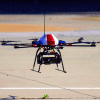
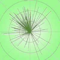
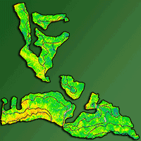
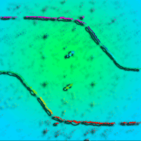
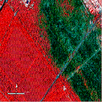
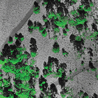
Forests are significant resources from an ecological, economic and social point of view. Their protection and management could greatly benefit from a complete knowledge of the shape and distribution of trees in forest stands. To this purpose, aerial surveys, especially through Airborne Laser Scanning (ALS), were carried out in the last years to acquire point clouds to be used in 3D models aimed at achieving an accurate description of tree crowns and terrain. However, airborne data acquisition is expensive and may provide poor results in case of dense foliage. Further, point cloud resolution is not very high, as models with a grid of 2-3 m are usually obtained. In order to implement more accurate 3D forest models, a feasible solution is the integration of point clouds obtained by aerial acquisition (ALS or photogrammetry) for the treetops and the terrain description, with information from terrestrial surveys. In this paper, we investigated the possible integration of point clouds obtained by Terrestrial Laser Scanner (TLS) with those collected by photogrammetric 3D models based on images captured by Unmanned Aerial Vehicle (UAV) in a test site located in northern Italy, with the aim of creating an accurate dataset of the forest site with high resolution and precision. The limits of ALS and TLS were bridged by aerial photogrammetry at low altitude (and vice versa). A 3D model of the study area was obtained with a resolution of 5 cm and a precision of 3 cm. Such model may be used in a wide range of applications in forestry studies, e.g., the reconstruction of 3D shapes of trees or the analysis of tree growth throught time. The implications of the use of such integrate approach as a support tool for decision-making in forest management are discussed.
Keywords
Data Integration, Forestry, Laser Scanner, Photogrammetry, Unmanned Aerial Vehicle, GNSS
Authors’ Info
Authors’ address
Paolo Dabove
Andrea Maria Lingua
Marco Piras
Environment, Land, and Infrastructure Department (DIATI), Politecnico di Torino, c.so Duca degli Abruzzi 24, I-10129 Turin (Italy)
Corresponding author
Paper Info
Citation
Aicardi I, Dabove P, Lingua AM, Piras M (2016). Integration between TLS and UAV photogrammetry techniques for forestry applications. iForest 10: 41-47. - doi: 10.3832/ifor1780-009
Academic Editor
Davide Travaglini
Paper history
Received: Jul 27, 2015
Accepted: Mar 04, 2016
First online: Jun 23, 2016
Publication Date: Feb 28, 2017
Publication Time: 3.70 months
Copyright Information
© SISEF - The Italian Society of Silviculture and Forest Ecology 2016
Open Access
This article is distributed under the terms of the Creative Commons Attribution-Non Commercial 4.0 International (https://creativecommons.org/licenses/by-nc/4.0/), which permits unrestricted use, distribution, and reproduction in any medium, provided you give appropriate credit to the original author(s) and the source, provide a link to the Creative Commons license, and indicate if changes were made.

Web Metrics
Breakdown by View Type
Article Usage
Total Article Views: 60760
(from publication date up to now)
Breakdown by View Type
HTML Page Views: 45475
Abstract Page Views: 4042
PDF Downloads: 9694
Citation/Reference Downloads: 80
XML Downloads: 1469
Web Metrics
Days since publication: 3621
Overall contacts: 60760
Avg. contacts per week: 117.46
Citation Metrics
Article Citations
Article citations are based on data periodically collected from the Clarivate Web of Science web site
(last update: Mar 2025)
Total number of cites (since 2017): 34
Average cites per year: 3.78
Publication Metrics
by Dimensions ©
Articles citing this article
List of the papers citing this article based on CrossRef Cited-by.
References
Application of terrestrial laser scanners for the determination of forest inventory parameters. In: Proceedings of the ISPRS Commission V Symposium “Image Engineering and Vision Metrology” (Mass H-G, Schneider D eds). Dresden (Germany) 25-27 Sep 2006. ISPRS, vol. 36, pp. 36.
Gscholar
The solid image: a new concept and its applications. In: “International Archives of Photogrammetry, Remote Sensing and Spatial Information Sciences”. ISPRS, Vol. 34, Part 6/W12, pp.78-82.
Gscholar
L’ortofoto solida di precisione: un prodotto innovativo per la rappresentazione e la gestione dei dati tridimensionali [The solid orthophoto: an innovative product for 3D data representation and management]. In: “Atti Conferenza Nazionale SIFET”. Taranto (Italy) 13-16 un 2006, pp. 8. [in Italian]
Online | Gscholar
UAV Photogrammetry. D. Sc. Thesis, University of Technology, Dresden, Germany, pp. 237.
Gscholar
Forest inventory attribute estimation using airborne laser scanning, aerial stereo imagery, radargrammetry and interferometry - Finnish experiences of the 3D techniques. ISPRS Annals of Photogrammetry, Remote Sensing and Spatial Information Sciences II-3/W4: 63-69.
CrossRef | Gscholar
Integration of TLS, close range photogrammetry and spatial information systems. In: Proceedings of the conference “Instrumentation and Measurement Technology” (I2MTC). Austin (TX, USA) May 2010. IEEE, pp. 1515-1520.
CrossRef | Gscholar
Italian National Forest Inventory: methods, state of the project and future developments. In: Proceedings of the “7th Annual Forest Inventory and Analysis Symposium”. Portland (ME, USA) 3-6 Oct 2005. ISPRS, pp. 55-66.
Gscholar
Development of photogrammetry system for grasping forest resources information. In: Proceedings of the XXII ISPRS Congress “International Archives of the Photogrammetry, Remote Sensing and Spatial Information Sciences”. Melbourne (Australia) 25 Aug - 01 Sep 2012. ISPRS, vol. 39-B8, pp. 447-450.
Online | Gscholar
Related Content

Ciesielski M, Sterenczak K
Vol. 12, pp. 498-510 (online: Dec 2019)
Brach M, Chan JCW, Szymanski P
Vol. 12, pp. 435-441 (online: Oct 2019)

Latifi H, Galos B
Vol. 3, pp. 98-101 (online: Jul 2010)
Shinzato ET, Shimabukuro YE, Coops NC, Tompalski P, Gasparoto EA
Vol. 10, pp. 296-302 (online: Feb 2017)

Jackson CM, Adam E
Vol. 13, pp. 286-300 (online: Aug 2020)
Spiazzi Favarin JA, Sabadi Schuh M, Marchesan J, Alba E, Soares Pereira R
Vol. 17, pp. 229-235 (online: Aug 2024)
Corona P, Lamonaca A, Chirici G
Vol. 1, pp. 6-12 (online: Feb 2008)
Martin H, Labbé S, Baldet P, Archaux F, Philippe G
Vol. 10, pp. 215-219 (online: Feb 2017)
León-Bañuelos LA, Endara-Agramont AR, Nava-Bernal EG, Gómez-Demetrio W
Vol. 16, pp. 282-289 (online: Oct 2023)
Sefercik UG, Atesoglu A
Vol. 10, pp. 491-497 (online: Apr 2017)


