Remote sensing support for post fire forest management
P Corona (1), A Lamonaca (1), G Chirici (2)
iForest - Biogeosciences and Forestry, Volume 1, Issue 1, Pages 6-12 (2008)
doi: https://doi.org/10.3832/ifor0305-0010006
Published: Feb 28, 2008 - Copyright © 2008 SISEF
Review Papers
Abstract
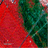
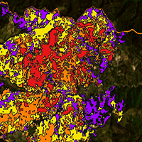
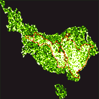
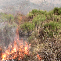
Monitoring of forest burnt areas has several aims: to locate and estimate the extent of such areas; to assess the damages suffered by the forest stands; to check the ability of the ecosystem to naturally recover after the fire; to support the planning of reclamation interventions; to assess the dynamics (pattern and speed) of the natural recovery; to check the outcome of any eventual restoration intervention. Remote sensing is an important source of information to support all such tasks. In the last decades, the effectiveness of remotely sensed imagery is increasing due to the advancement of tools and techniques, and to the lowering of the costs, in relative terms. For an effective support to post-fire management (burnt scar perimeter mapping, damage severity assessment, post-fire vegetation monitoring), a mapping scale of at least 1:10000-1:20000 is required: hence, the selection of remotely sensed data is restricted to aerial imagery and to satellite imagery characterized by high (HR) and, above all, very high (VHR) spatial resolution. In the last decade, HR and VHR passive (optical) remote sensing has widespread, providing affordable multitemporal and multispectral pictures of the considered phenomena, at different scales (spatial, temporal and spectral resolutions) with reference to the monitoring needs. In the light of such a potential, the integration of GPS field survey and imagery by light aerial vectors or VHR satellite is currently sought as a viable option for the post-fire monitoring.
Keywords
Burnt scar perimeter mapping, Post-fire vegetation monitoring, Damage severity assessment, High and very high spatial resolution satellite sensors
Authors’ Info
Authors’ address
A Lamonaca
Dipartimento di Scienze dell’Ambiente Forestale e delle sue Risorse, Università della Tuscia, v. San Camillo de Lellis snc, 01100 Viterbo (Italy)
Dipartimento di Scienze e Tecnologie per l’Ambiente e il Territorio, Università del Molise, c.da Fonte Lappone snc, 86090 Pesche, IS (Italy)
Corresponding author
Paper Info
Citation
Corona P, Lamonaca A, Chirici G (2008). Remote sensing support for post fire forest management. iForest 1: 6-12. - doi: 10.3832/ifor0305-0010006
Paper history
Received: Oct 19, 2007
Accepted: Jan 23, 2008
First online: Feb 28, 2008
Publication Date: Feb 28, 2008
Publication Time: 1.20 months
Copyright Information
© SISEF - The Italian Society of Silviculture and Forest Ecology 2008
Open Access
This article is distributed under the terms of the Creative Commons Attribution-Non Commercial 4.0 International (https://creativecommons.org/licenses/by-nc/4.0/), which permits unrestricted use, distribution, and reproduction in any medium, provided you give appropriate credit to the original author(s) and the source, provide a link to the Creative Commons license, and indicate if changes were made.

Web Metrics
Breakdown by View Type
Article Usage
Total Article Views: 74155
(from publication date up to now)
Breakdown by View Type
HTML Page Views: 59679
Abstract Page Views: 4888
PDF Downloads: 8104
Citation/Reference Downloads: 103
XML Downloads: 1381
Web Metrics
Days since publication: 6688
Overall contacts: 74155
Avg. contacts per week: 77.61
Citation Metrics
Article Citations
Article citations are based on data periodically collected from the Clarivate Web of Science web site
(last update: Mar 2025)
Total number of cites (since 2008): 25
Average cites per year: 1.39
Publication Metrics
by Dimensions ©
Articles citing this article
List of the papers citing this article based on CrossRef Cited-by.
References
Satellite based monitoring of Tuscany wildfires. In: Remote sensing and forest monitoring (Zawila-Niedzwiecki T, Brach M eds), Office for Official Pubblications of the European Communities. European Commission, Luxembourg, Environment and quality of life series XII: 573-583.
Gscholar
Progetto SIMIB: mappe degli incendi e valutazione dei danni da oggi a portata di mouse. Silvae 5: 73-98.
Gscholar
Confronto e integrazione di dati telerilevati Ikonos e Landsat 7 ETM+ nella valutazione dei danni da incendio in ambiente mediterraneo: il caso della pineta di Castel Fusano. In: Atti, Conferenza ASITA, La qualità nell’informazione geografica, Rimini, volume I, pp. 529-537.
Gscholar
Utilizzo di immagini satellitari ad alta risoluzone nel rilevamento delle risorse forestali. Aracne Editrice, Roma, Italy.
Gscholar
Confronto di approcci correlativi per il monitoraggio satellitare del recupero post-incendio della vegetazione forestale. Atti della 10° Conferenza Nazionale ASITA, Bolzano, 14-17 novembre 2006, pp. 685-690.
Gscholar
Forest Fires in Europe 2005. European Commission, Joint Research Centre, Institute for Environment and Sustainability, Report No 6, EUR 22312 EN, Italy.
Gscholar
Remote sensing for sustainable forest management. CRC Press, Boca Raton, USA.
Gscholar
Il catasto degli incendi boschivi della Regione Campania: un sistema su WEB per l’applicazione della Legge Quadro 353/2000. MondoGIS 44: 31-34.
Gscholar
Remote Sensing and Image Interpretation. Fifth Edition. John Wiley & Sons, USA.
Gscholar
Airborne forest fire mapping with an adaptive infrared sensor. International Journal of Remote Sensing 24 (18): 3663-3682.
CrossRef | Gscholar
Effects of fire size and pattern on early succession in Yellowstone National Park. Ecological Monographs 67: 411-433.
Gscholar
Remote Sensing of Forest Environments: Concepts and Case Studies. Kluwer, Dordrecht, Netherlands.
Gscholar
Related Content
Coschignano G, Nicolaci A, Ferrari E, Cruscomagno F, Iovino F
Vol. 12, pp. 427-434 (online: Oct 2019)
Jayasekara D, Dhananjani T, Mendis V, Jayawickrama H, Prasad T, Gunarathna MM, Gunarathna P, Mahaulpatha D
Vol. 18, pp. 45-53 (online: Apr 2025)

Latifi H, Galos B
Vol. 3, pp. 98-101 (online: Jul 2010)

Coskuner KA
Vol. 15, pp. 85-94 (online: Apr 2022)

Ciesielski M, Sterenczak K
Vol. 12, pp. 498-510 (online: Dec 2019)
Vaglio Laurin G, Avezzano R, Bacciu V, Frate FD, Papale D, Virelli M
Vol. 11, pp. 389-395 (online: Jun 2018)

Jackson CM, Adam E
Vol. 13, pp. 286-300 (online: Aug 2020)
Cavalli A, Francini S, Cecili G, Cocozza C, Congedo L, Falanga V, Spadoni GL, Maesano M, Munafò M, Chirici G, Scarascia Mugnozza G
Vol. 15, pp. 220-228 (online: Aug 2022)
Jonikavičius D, Mozgeris G
Vol. 6, pp. 150-155 (online: Jun 2013)
Marzano R, Lingua E, Garbarino M
Vol. 5, pp. 93-100 (online: Jun 2012)


