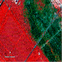
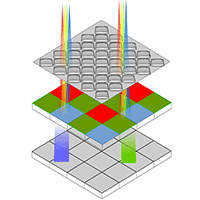
Forest resource conservation necessitates a deeper understanding of forest ecosystem processes and how future management decisions and climate change may affect these processes. Argania spinosa (L.) Skeels is one of the most popular species in Morocco. Despite its ability to survive under harsh drought, it is endangered due to soil land removal and a lack of natural regeneration. Remote sensing offers a powerful resource for mapping, assessing, and monitoring the forest tree species at high spatio-temporal resolution. Multi-spectral Sentinel-2 and Synthetic Aperture Radar (SAR) time series combined with Digital Elevation Model (DEM) over the Argan forest in Essaouira province, Morocco, were subjected to pixel-based machine learning classification and analysis. We investigated the influence of different SAR data parameters and DEM layers on the performance of machine learning algorithms. In addition, we evaluated the synergistic effects of integrating remote sensing data, including optical, SAR, and DEM data, for identifying argan trees in the Smimou area. We collected data from Sentinel-2, Sentinel-1, SRTM DEM, and ground truth sources to achieve our goal. Testing different SAR parameters and integrating DEM layers of different resolutions with other remote sensing data showed that the Lee Sigma filter with a size of 11×11 and a DEM layer of 30 m resolution gave the best results using the Support Vector Machine algorithm. Significant improvements in overall accuracy (OA) and kappa index (K) were observed in the following phase. After applying a smoothing technique, the combined use of two Sentinel constellation products improved map accuracy and quality. For the best scenario (VV+NDVI), the OA was 88.32% (K = 0.85), while for scenarios NDVI+DEM and VH+NDVI+DEM, the OAs were 93.25% (K = 0.91) and 93.01% (K = 0.91), respectively. Integrating a DEM layer with SAR and optical data has significantly improved the accuracy in the classification of vegetation types, especially in our study area which is characterized by high environmental heterogeneity.
Keywords
, , , , ,
Citation
El Moussaoui EH, Moumni A, Lahrouni A (2024). Assessing the influence of different Synthetic Aperture Radar parameters and Digital Elevation Model layers combined with optical data on the identification of argan forest in Essaouira region, Morocco. iForest 17: 100-108. - doi: 10.3832/ifor4183-016
Academic Editor
Agostino Ferrara
Paper history
Received: Jul 15, 2022
Accepted: Apr 17, 2024
First online: Apr 24, 2024
Publication Date: Apr 30, 2024
Publication Time: 0.23 months
© SISEF - The Italian Society of Silviculture and Forest Ecology 2024
Open Access
This article is distributed under the terms of the Creative Commons Attribution-Non Commercial 4.0 International (https://creativecommons.org/licenses/by-nc/4.0/), which permits unrestricted use, distribution, and reproduction in any medium, provided you give appropriate credit to the original author(s) and the source, provide a link to the Creative Commons license, and indicate if changes were made.

Breakdown by View Type
(Waiting for server response...)
Article Usage
Total Article Views: 10974
(from publication date up to now)
Breakdown by View Type
HTML Page Views: 4669
Abstract Page Views: 2812
PDF Downloads: 3140
Citation/Reference Downloads: 2
XML Downloads: 351
Web Metrics
Days since publication: 829
Overall contacts: 10974
Avg. contacts per week: 92.66
Article Citations
Article citations are based on data periodically collected from the Clarivate Web of Science web site
(last update: Jul 2026)
(No citations were found up to date. Please come back later)
Publication Metrics
by Dimensions ©
Articles citing this article
List of the papers citing this article based on CrossRef Cited-by.
(1)
Akar O, Güngör O (2015)Integrating multiple texture methods and NDVI to the Random Forest classification algorithm to detect tea and hazelnut plantation areas in northeast Turkey. International Journal of Remote Sensing 36: 442-464.
CrossRef |
Gscholar
(2)
Ali OS, Hachemi A, Moumni A, Belghazi T, Lahrouni A, El Messoussi S (2021)Physiological and biochemical responses of argan (
Argania spinosa L.) seedlings from containers of different depths under water stress. Notulae Botanicae Horti Agrobotanici Cluj-Napoca 49: 1-17.
CrossRef |
Gscholar
(3)
Amoakoh AO, Aplin P, Awuah KT, Delgado-Fernandez I, Moses C, Alonso CP, Kankam S, Mensah JC (2021)Testing the contribution of multi-source remote sensing features for Random Forest classification of the Greater Amanzule Tropical Peatland. Remote Sensors 3399: 1-25.
CrossRef |
Gscholar
(4)
Barakat A, Khellouk R, El Jazouli A, Touhami F, Nadem S (2018)Monitoring of forest cover dynamics in eastern area of Béni-Mellal Province using ASTER and Sentinel-2A multispectral data. Geology, Ecology, and Landscapes 2: 203-215.
CrossRef |
Gscholar
(5)
Benmahioul B, Hamiani M, Belaroug I, Zerhouni S (2006)Inductions morphogenetiques en culture
in vitro de l’Arganier:
Argania spinosa L. [Morphogenetic Inductions in
in vitro culture of the argan tree:
Argania spinosa L.]. Journal Algérien des Régions Arides 5: 38-48. [in French]
Gscholar
(6)
Brovelli MA, Molinari ME, Hussein E, Chen J, Li R (2015)The first comprehensive accuracy assessment of GlobLand30 at a national level: methodology and results. Remote Sensing 7: 4191-4212.
CrossRef |
Gscholar
(7)
Caballero GR, Platzeck G, Pezzola A, Casella A, Winschel C, Silva SS, Ludueña E, Pasqualotto N, Delegido J (2020)Assessment of multi-date Sentinel-1 polarizations and GLCM texture features capacity for onion and sunflower classification in an irrigated valley: an object level approach. Agronomy 10: 1-27.
CrossRef |
Gscholar
(8)
Chakhar A, Hernández-López D, Ballesteros R, Moreno MA (2021)Improving the accuracy of multiple algorithms for crop classification by integrating sentinel-1 observations with Sentinel-2 data. Remote Sensing 13: 1-21.
CrossRef |
Gscholar
(9)
Clauss K, Ottinger M, Kuenzer C (2018)Mapping rice areas with Sentinel-1 time series and superpixel segmentation. International Journal of Remote Sensing 39: 1399-1420.
CrossRef |
Gscholar
(10)
Demarez V, Helen F, Marais-Sicre C, Baup F (2019)In-season mapping of irrigated crops using Landsat 8 and Sentinel-1 time series. Remote Sensing 11: 1-14.
CrossRef |
Gscholar
(11)
Dubeau P, King DJ, Unbushe DG, Rebelo LM (2017)Mapping the Dabus Wetlands, Ethiopia, using random forest classification of Landsat, PALSAR and topographic data. Remote Sensing 9: 1-23.
CrossRef |
Gscholar
(12)
El-Deentaha L (2017)Assessment of urban land cover classification using Wishart and Support Vector Machine (SVM) based on different decomposition parameters of fully-polarimetric SAR. Journal of Geomatics 11: 1-11.
Online |
Gscholar
(13)
El Moussaoui E, Moumni A, Lahrouni A (2021)Cartography of Moroccan argan tree using combined optical and SAR imagery integrated with digital elevation model. The International Archives of the Photogrammetry, Remote Sensing and Spatial Information Sciences 46: 27-29.
CrossRef |
Gscholar
(14)
Faouzi K, Rharrabti Y, Boukroute A, Mahyou H, Berrichi A (2015)Cartographie de l’aire de répartition de l’arganier (
Argania spinosa) [Mapping the distribution area of the argan tree]. Nature and Technology 12: 16-24. [in French]
Online |
Gscholar
(15)
Fisher A, Danaher T, Gill T (2017)Mapping trees in high resolution imagery across large areas using locally variable thresholds guided by medium resolution tree maps. International Journal of Applied Earth Observation and Geoinformation 58: 86-96.
CrossRef |
Gscholar
(16)
Furze S, Ogilvie J, Arp PA (2017)Fusing digital elevation models to improve hydrological interpretations. Journal of Geographic Information System 9: 558-575.
CrossRef |
Gscholar
(17)
Gao Y, Liu P, Wu Y, Jia K (2016)Quadtree Degeneration for HEVC. IEEE Transactions on Multimedia 18: 2321-2330.
CrossRef |
Gscholar
(18)
Genin D, Simenel R (2011)Endogenous Berber forest management and the functional shaping of rural forests in Southern Morocco: implications for shared forest management options. Human Ecology 39: 257-269.
CrossRef |
Gscholar
(19)
Inglada J, Vincent A, Arias M, Marais-Sicre C (2016)Improved early crop type identification by joint use of high temporal resolution sar and optical image time series. Remote Sensing 8: 1-21.
CrossRef |
Gscholar
(20)
Jia M, Tong L, Zhang Y, Chen Y (2013)Multitemporal radar backscattering measurement of wheat fields using multifrequency (L, S, C, and X) and full-polarization. Radio Science 48: 471-481.
CrossRef |
Gscholar
(21)
Khallouki F, Haubner R, Ricarte I, Erben G, Klika K, Ulrich CM, Owen RW (2015)Identification of polyphenolic compounds in the flesh of Argan (Morocco) fruits. Food Chemistry 179: 191-198.
CrossRef |
Gscholar
(22)
Koskela J, Vinceti B, Dvorak W, Bush D, Dawson IK, Loo J, Dahl E, Navarro C, Padolina C, Bordács S, Jamnadass R, Graudal L (2014)Utilization and transfer of forest genetic resources: a global review. Forest Ecology and Management 333: 22-34.
CrossRef |
Gscholar
(23)
Liu S, Qi Z, Li X, Yeh AGO (2019)Integration of convolutional neural networks and object-based post-classification refinement for land use and land cover mapping with optical and sar data. Remote Sensing 11: 1-25.
CrossRef |
Gscholar
(24)
Martinez Del Castillo E, García-Martin A, Longares Aladrén LA, De Luis M (2015)Evaluation of forest cover change using remote sensing techniques and landscape metrics in Moncayo Natural Park (Spain). Applied Geography 62: 247-255.
CrossRef |
Gscholar
(25)
Mohajane M, Essahlaoui A, Oudija F, El Hafyani M, Teodoro AC (2017)Mapping forest species in the Central Middle Atlas of Morocco (Azrou Forest) through remote sensing techniques. ISPRS International Journal of Geo-Information 6: 1-10.
CrossRef |
Gscholar
(26)
Moumni A, Belghazi T, Maksoudi B, Lahrouni A (2021)Argan tree (
Argania spinosa (L.) Skeels) mapping based on multisensor fusion of satellite imagery in Essaouira province, Morocco. Journal of Sensors 2021: 6679914.
CrossRef |
Gscholar
(27)
Moumni A, Lahrouni A (2021)Machine learning-based classification for crop-type mapping using the fusion of high-resolution satellite imagery in a semiarid area. Scientifica 2021: 20.
CrossRef |
Gscholar
(28)
Mustak S, Uday G, Ramesh B, Praveen B (2019)Evaluation of the performance of SAR and SAR-optical fused dataset for crop discrimination. International Archives of the Photogrammetry, Remote Sensing and Spatial Information Sciences - ISPRS Archives 42: 563-571.
CrossRef |
Gscholar
(29)
Potin P, Rosich B, Miranda N, Grimont P, Shurmer I, O’Connell A, Krassenburg M, Gratadour JB (2018)Sentinel-1 constellation mission operations status. In: Proceedings of the “International Geoscience and Remote Sensing Symposium - IGARSS”. Valencia (Spain) 22-27 July 2018. IEEExplore, pp. 1547-1550.
CrossRef |
Gscholar
(30)
Qin Y, Xiao X, Dong J, Zhang G, Shimada M, Liu J, Li C, Kou W, Moore B (2015)Forest cover maps of China in 2010 from multiple approaches and data sources: PALSAR, Landsat, MODIS, FRA, and NFI. ISPRS Journal of Photogrammetry and Remote Sensing 109: 1-16.
CrossRef |
Gscholar
(31)
Rajadell O, García-Sevilla P, Pla F (2009)Textural features for hyperspectral pixel classification BT - Image and signal processing. In: “Pattern Recognition and Image Analysis. IbPRIA 2009” (Araujo H, Mendonça AM, Pinho AJ, Torres MI eds). Lecture Notes in Computer Science, vol. 5524, Springer, Berlin, Heidelberg, Germany, pp. 209-216.
CrossRef |
Gscholar
(32)
Sabat-Tomala A, Raczko E, Zagajewski B (2020)Comparison of support vector machine and random forest algorithms for invasive and expansive species classification using airborne hyperspectral data. Remote Sensing. 12: 23.
CrossRef |
Gscholar
(33)
Said Ali O, Hachemi A, Moumni A, Zine H, Elgadi S, Belghazi T, Ouhammou A, Lahrouni A, El Messoussi S (2022)Argan (
Argania spinosa (L.) Skeels) seed germination under some pretreatments of thermal shocks. Kastamonu University Journal of Forestry Faculty 22: 56-67.
CrossRef |
Gscholar
(34)
Sebbar B, Moumni A, Lahrouni A, Chehbouni A, Belghazi T, Maksoudi B (2022)Remotely sensed phenology monitoring and land-cover classification for the localization of the endemic argan tree in the Southern-west of Morocco. Journal of Sustainable Forestry 41: 1014-1028.
CrossRef |
Gscholar
(35)
Shahtahmassebi AR, Li C, Fan Y, Wu Y, Lin Y, Gan M, Wang K, Malik A, Blackburn GA (2021)Remote sensing of urban green spaces: a review. Urban Forestry and Urban Greening 57: 126946.
CrossRef |
Gscholar
(36)
Sinsin TEM, Mounir F, Aboudi El A (2020)Conservation, valuation and sustainable development issues of the Argan Tree Biosphere Reserve in Morocco. Environmental and Socio-Economic Studies 8: 28-35.
CrossRef |
Gscholar
(37)
Sirro L, Häme T, Rauste Y, Kilpi J, Hämäläinen J, Gunia K, De Jong B, Pellat FP (2018)Potential of different optical and SAR data in forest and land cover classification to support REDD+ MRV. Remote Sensing 10: 942.
CrossRef |
Gscholar
(38)
Su Y, Guo Q, Xue B, Hu T, Alvarez O, Tao S, Fang J (2016)Remote sensing of environment spatial distribution of forest aboveground biomass in China: estimation through combination of spaceborne lidar, optical imagery, and forest inventory data. Remote Sensing of Environment 173: 187-199.
CrossRef |
Gscholar
(39)
Tavares PA, Beltrão NES, Guimarães US, Teodoro AC (2019)Integration of Sentinel-1 and Sentinel-2 for classification and LULC mapping in the urban area of Belém, eastern Brazilian Amazon. Sensors 19: 1140.
CrossRef |
Gscholar
(40)
Torbick N, Chowdhury D, Salas W, Qi J (2017)Monitoring rice agriculture across myanmar using time series Sentinel-1 assisted by Landsat-8 and PALSAR-2. Remote Sensing 9: 119.
CrossRef |
Gscholar
(41)
Veloso A, Mermoz S, Bouvet A, Le Toan T, Planells M, Dejoux JF, Ceschia E (2017)Understanding the temporal behavior of crops using Sentinel-1 and Sentinel-2-like data for agricultural applications. Remote Sensing of Environment 199: 415-426.
CrossRef |
Gscholar
(42)
Yu Y, Li M, Fu Y (2018)Forest type identification by random forest classification combined with SPOT and multitemporal SAR data. Journal of Forestry Research 29: 1407-1414.
CrossRef |
Gscholar
(43)
Yuan Q, Cong G, Magnenat Thalmann N (2012)Enhancing naive bayes with various smoothing methods for short text classification. In: Proceedings of the “21st International Conference on World Wide Web - WWW ’12 Companion”. Lyon (France) 16 Apr 2012, Poster. ACM Diigital Library, pp. 645-646.
CrossRef |
Gscholar
(44)
Zakeri H, Yamazaki F, Liu W (2017)Texture analysis and land cover classification of tehran using polarimetric synthetic aperture radar imagery. Applied Sciences 7: 452.
CrossRef |
Gscholar
(45)
Zhang X, Cui J, Wang W, Lin C (2017)A study for texture feature extraction of high-resolution satellite images based on a direction measure and gray level co-occurrence matrix fusion algorithm. Sensors 17: 1474.
CrossRef |
Gscholar