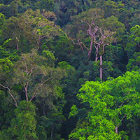
Mapping the vegetation and spatial dynamics of Sinharaja tropical rain forest incorporating NASA’s GEDI spaceborne LiDAR data and multispectral satellite images
Dulan Jayasekara (1) , Tharanga Dhananjani (1-2), Vinuri Mendis (2-3), Harsha Jayawickrama (4), Tharanga Prasad (5), Maleesha M Gunarathna (6), Pethigelaye Gunarathna (5), Dharshani Mahaulpatha (1)
iForest - Biogeosciences and Forestry, Volume 18, Issue 2, Pages 45-53 (2025)
doi: https://doi.org/10.3832/ifor4632-017
Published: Apr 01, 2025 - Copyright © 2025 SISEF
Research Articles
Abstract
This study integrates NASA’s Global Ecosystem Dynamics Investigation (GEDI) spaceborne LiDAR data with multispectral satellite imagery to map the vegetation and assess spatial dynamics within the Sinharaja Forest Reserve (SFR). Utilizing advanced remote sensing techniques, we delineated vegetation structure, vegetation density distribution, and canopy cover at high spatial resolutions. Eight distinct vegetation/land cover types were identified by this work and an updated vegetation map was developed for SFR. The resulted map recorded an estimated overall accuracy of 90% (Kappa coefficient 0.9) by the accuracy assessment. Comprehensive insights into forest composition and spatial dynamics were achieved with regard to canopy heights, plant area index and plant area volume density. Our results suggest that the integration of GEDI LiDAR and satellite imaging data offers a robust framework for characterizing tropical forest ecosystems, facilitating better understanding of their ecological processes, and informing conservation and management strategies.
Keywords
Forest Dynamics, Remote Sensing, Land Cover, Forest Ecology, Vegetation Density
Authors’ Info
Authors’ address
Tharanga Dhananjani 0000-0001-8446-4678
Dharshani Mahaulpatha 0000-0002-6563-7462
Department of Zoology, Faculty of Applied Sciences, University of Sri Jayewardenepura, Gangodawila (Sri Lanka)
Vinuri Mendis 0009-0006-3540-0006
Faculty of Graduate Studies, University of Sri Jayewardenepura, Gangodawila (Sri Lanka)
Faculty of Graduate Studies, University of Manitoba, Winnipeg, Manitoba, R3T 2N2 (Canada)
Faculty of Applied Sciences, Uva Wellassa University, Badulla 90000 (Sri Lanka)
Faculty of Technology, University of Sri Jayewardenepura (Sri Lanka)
Corresponding author
Paper Info
Citation
Jayasekara D, Dhananjani T, Mendis V, Jayawickrama H, Prasad T, Gunarathna MM, Gunarathna P, Mahaulpatha D (2025). Mapping the vegetation and spatial dynamics of Sinharaja tropical rain forest incorporating NASA’s GEDI spaceborne LiDAR data and multispectral satellite images. iForest 18: 45-53. - doi: 10.3832/ifor4632-017
Academic Editor
Marco Borghetti
Paper history
Received: Apr 26, 2024
Accepted: Dec 05, 2024
First online: Apr 01, 2025
Publication Date: Apr 30, 2025
Publication Time: 3.90 months
Copyright Information
© SISEF - The Italian Society of Silviculture and Forest Ecology 2025
Open Access
This article is distributed under the terms of the Creative Commons Attribution-Non Commercial 4.0 International (https://creativecommons.org/licenses/by-nc/4.0/), which permits unrestricted use, distribution, and reproduction in any medium, provided you give appropriate credit to the original author(s) and the source, provide a link to the Creative Commons license, and indicate if changes were made.

Web Metrics
Breakdown by View Type
Article Usage
Total Article Views: 13837
(from publication date up to now)
Breakdown by View Type
HTML Page Views: 7718
Abstract Page Views: 2820
PDF Downloads: 2967
Citation/Reference Downloads: 0
XML Downloads: 332
Web Metrics
Days since publication: 482
Overall contacts: 13837
Avg. contacts per week: 200.95
Citation Metrics
Article Citations
Article citations are based on data periodically collected from the Clarivate Web of Science web site
(last update: Mar 2025)
(No citations were found up to date. Please come back later)
Publication Metrics
by Dimensions ©
Articles citing this article
List of the papers citing this article based on CrossRef Cited-by.
References
Spatial Patterns of Trees in the Sinharaja Forest in Sri Lanka. Proceeding of the “15th Open University Research Sessions” (OURS 2017). The Open University of Sri Lanka, Nawala, Sri Lanka, pp. 505-508.
Gscholar
Guide to Sinharaja: a biodiversity hotspot of the world. IUCN Sri Lanka, Colombo, Sri Lanka, pp. 51.
Gscholar
Sinharaja, a rain forest in Sri Lanka. March for Conservation, Colombo, Sri Lanka, pp. 61.
Gscholar
The Global Ecosystem Dynamics Investigation: High-resolution laser ranging of the Earth’s forests and topography. Science of Remote Sensing 1: 100002.
CrossRef | Gscholar
Plant biogeography and conservation of the southwestern hill forests of Sri Lanka. The Raffles Bulletin of Zoology 12 (1): 9-22.
Gscholar
Present status of lowland wet zone flora of Sri Lanka. In: The National Red List 2012 of Sri Lanka (Weerakoon DK, Wijesundara S eds). Biodiversity Secretariat of the Ministry of Environment and National Herbarium, Ministry of Environment, Colombo, Sri Lanka, pp. 175-452.
Gscholar
Change detection using mappable vegetation related indices - A case study from Sinharaja Forest Reserve. In: Proceedings of the “18th International Forestry and Environment Symposium. Department of Forestry and Environmental Science 2013”. University of Sri Jayewardenepura, Nugegoda, Sri Lanka, pp. 69.
CrossRef | Gscholar
Exploring the relation between remotely sensed vertical canopy structure and tree species diversity in Gabon. Environmental Research Letters 14: 094013.
CrossRef | Gscholar
Estimation of above-ground carbon stock in the Sinharaja Forest in Sri Lanka. In Proceedings of the “First National Conference on Global Climate Change and its Impacts on Agriculture, Forestry and Water in the Tropics” (Nissanka S, Sangakkara UR eds). University of Peradeniya, Peradeniya, Sri Lanka, pp. 140-151.
Gscholar
Mapping global forest canopy height through integration of GEDI and Landsat data. Remote Sensing of Environment 253: 112165.
CrossRef | Gscholar
Related Content

Latifi H, Galos B
Vol. 3, pp. 98-101 (online: Jul 2010)

Ciesielski M, Sterenczak K
Vol. 12, pp. 498-510 (online: Dec 2019)

Jackson CM, Adam E
Vol. 13, pp. 286-300 (online: Aug 2020)
Cavalli A, Francini S, Cecili G, Cocozza C, Congedo L, Falanga V, Spadoni GL, Maesano M, Munafò M, Chirici G, Scarascia Mugnozza G
Vol. 15, pp. 220-228 (online: Aug 2022)
Martin H, Labbé S, Baldet P, Archaux F, Philippe G
Vol. 10, pp. 215-219 (online: Feb 2017)
Corona P, Lamonaca A, Chirici G
Vol. 1, pp. 6-12 (online: Feb 2008)

Coskuner KA
Vol. 15, pp. 85-94 (online: Apr 2022)
Martin H, Monnet JM, De Boisvilliers M, Chevalier R, Villar M
Vol. 13, pp. 409-416 (online: Oct 2020)
Figueiredo De Souza RL, Dionizio EA, Lopes Cavalcante RB
Vol. 19, pp. 85-93 (online: Apr 2026)
Mancino G, Nolè A, Urbano V, Amato M, Ferrara A
Vol. 2, pp. 154-161 (online: Jul 2009)


