*
 

iForest - Biogeosciences and Forestry

*

Estimating biomass of mixed and uneven-aged forests using spectral data and a hybrid model combining regression trees and linear models

Pablito M López-Serrano (1), Carlos A López-Sánchez (2)   , Ramón A Díaz-Varela (3), José J Corral-Rivas (2), Raúl Solís-Moreno (4), Benedicto Vargas-Larreta (5), Juan G Álvarez-González (6)

iForest - Biogeosciences and Forestry, Volume 9, Issue 2, Pages 226-234 (2015)
doi: https://doi.org/10.3832/ifor1504-008
Published: Sep 21, 2015 - Copyright © 2015 SISEF

Research Articles


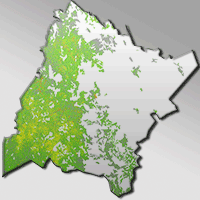
The Sierra Madre Occidental mountain range (Durango, Mexico) is of great ecological interest because of the high degree of environmental heterogeneity in the area. The objective of the present study was to estimate the biomass of mixed and uneven-aged forests in the Sierra Madre Occidental by using Landsat-5 TM spectral data and forest inventory data. We used the ATCOR3® atmospheric and topographic correction module to convert remotely sensed imagery digital signals to surface reflectance values. The usual approach of modeling stand variables by using multiple linear regression was compared with a hybrid model developed in two steps: in the first step a regression tree was used to obtain an initial classification of homogeneous biomass groups, and multiple linear regression models were then fitted to each node of the pruned regression tree. Cross-validation of the hybrid model explained 72.96% of the observed stand biomass variation, with a reduction in the RMSE of 25.47% with respect to the estimates yielded by the linear model fitted to the complete database. The most important variables for the binary classification process in the regression tree were the albedo, the corrected readings of the short-wave infrared band of the satellite (2.08-2.35 µm) and the topographic moisture index. We used the model output to construct a map for estimating biomass in the study area, which yielded values of between 51 and 235 Mg ha-1. The use of regression trees in combination with stepwise regression of corrected satellite imagery proved a reliable method for estimating forest biomass.

  Keywords


Regression Trees, Stepwise Regression, Remote Sensing, ATCOR3, Terrain Features, Image Texture

Authors’ address

(1)
Pablito M López-Serrano
DICAF, Universidad Juárez del Estado de Durango, Boulevard del Guadiana 501, Ciudad Universitaria, Torre de Investigación, 34120 Durango, Dgo (México)
(2)
Carlos A López-Sánchez
José J Corral-Rivas
Instituto de Silvicultura e Industria de la Madera, Universidad Juárez del Estado de Durango, Boulevard del Guadiana 501, Ciudad Universitaria, Torre de Investigación, 34120 Durango, Dgo (México)
(3)
Ramón A Díaz-Varela
Departamento de Botánica - IBADER, Universidad de Santiago de Compostela, Escuela Politécnica Superior, Lugo (España)
(4)
Raúl Solís-Moreno
Facultad de Ciencias Forestales, Universidad Juárez del Estado de Durango, Río Papaloapan 132, Valle del Sur Durango, 34120 Durango, Dgo (México)
(5)
Benedicto Vargas-Larreta
División de Estudios de Posgrado e Investigación, Instituto Tecnológico de El Salto, Mesa del Tecnológico s/n, 34942, El Salto, Dgo (México)
(6)
Juan G Álvarez-González
Departamento de Ingeniería Agroforestal, Universidad de Santiago de Compostela, Escuela Politécnica Superior, Lugo (España)

Corresponding author

 
Carlos A López-Sánchez
calopez@ujed.mx

Citation

López-Serrano PM, López-Sánchez CA, Díaz-Varela RA, Corral-Rivas JJ, Solís-Moreno R, Vargas-Larreta B, Álvarez-González JG (2015). Estimating biomass of mixed and uneven-aged forests using spectral data and a hybrid model combining regression trees and linear models. iForest 9: 226-234. - doi: 10.3832/ifor1504-008

Academic Editor

Davide Travaglini

Paper history

Received: Nov 17, 2014
Accepted: May 17, 2015

First online: Sep 21, 2015
Publication Date: Apr 26, 2016
Publication Time: 4.23 months

Breakdown by View Type

(Waiting for server response...)

Article Usage

Total Article Views: 44446
(from publication date up to now)

Breakdown by View Type
HTML Page Views: 36369
Abstract Page Views: 2369
PDF Downloads: 4352
Citation/Reference Downloads: 73
XML Downloads: 1283

Web Metrics
Days since publication: 3133
Overall contacts: 44446
Avg. contacts per week: 99.30

Article Citations

Article citations are based on data periodically collected from the Clarivate Web of Science web site
(last update: Feb 2023)

Total number of cites (since 2016): 10
Average cites per year: 1.25


Publication Metrics

by Dimensions ©

Articles citing this article

List of the papers citing this article based on CrossRef Cited-by.

 
(1)
Aguirre-Salado CA, Aguirre-Salado EJ, Treviño-Garza OA, Aguirre-Calderón J, Jiménez-Pérez MA, González-Tagle JR, Valdéz-Lazalde G, Sánchez-Díaz RH, Aguirre-Salado AI, Miranda-Aragón L (2014)
Mapping aboveground biomass by integrating geospatial and forest inventory data through a k-nearest neighbour strategy in North Central Mexico. Journal of Arid Land 1: 80-96.
CrossRef | Gscholar
(2)
Asrar G (1989)
Theory and applications of optical remote sensing. John Wiley and Sons, New York, USA, pp. 734.
Online | Gscholar
(3)
Asrar G, Fuchs M, Kanemasu ET, Hatfield JL (1984)
Estimating absorbed photosynthetically active radiation and leaf area index from spectral reflectance in wheat. Agronomy Journal 76 (2): 300-306.
CrossRef | Gscholar
(4)
Balthazar V, Veerle V, Eric FL (2012)
Evaluation and parameterization of ATCOR3 topographic correction method for forest cover mapping in mountain areas. International Journal of Applied Earth Observation and Geoinformation 18: 436-450.
CrossRef | Gscholar
(5)
Baret F, Guyot G (1991)
Potentials and limits of vegetation indices for LAI and APAR assessment. Remote Sensing of Environment 35: 161-173.
CrossRef | Gscholar
(6)
Belsey DA (1991)
Conditioning diagnostics, collinearity and weak data in regression. John Wiley and Sons Inc, New York, USA, pp. 396.
Gscholar
(7)
Botero VJS, Restrepo MA (2010)
Análisis de textura en panes usando la matriz de coocurrencia [Analysis of texture in breads using the co-occurrence matrix]. Revista Politécnica 6 (10): 74-80. [in Spanish]
Gscholar
(8)
Breiman L, Friedman JH, Olshen RA, Stone CJ (1984)
Classification and regression trees. Chapman and Hall, New York, USA, pp. 368.
Gscholar
(9)
Brown S, Lugo AE (1984)
Biomass of tropical forests: a new estimate based on forest volumes. Science 223 (4642): 1290-1293.
CrossRef | Gscholar
(10)
Brutsaert W (1975)
On a derivable formula for long-wave radiation from clear skies. Water Resources Research 11: 742-744.
CrossRef | Gscholar
(11)
Challenger A (1998)
Utilización y conservación de los ecosistemas terrestres de México: pasado, presente y futuro [Use and conservation of terrestrial ecosystems of Mexico: past, present and future]. Comisión Nacional para el Conocimiento y Uso de la Biodiversidad/Instituto de Biología, UNAM/Agrupación Sierra Madre, México, DF, pp. 847. [in Spanish]
Gscholar
(12)
Chen D, Stow DA, Gong P (2004)
Examining the effect of spatial resolution and texture window size on classification accuracy: an urban environment case. International Journal of Remote Sensing 25 (11): 2177-2192.
CrossRef | Gscholar
(13)
Corral-Rivas J, Vargas B, Wehenkel C, Aguirre O, Alvarez JG, Rojo A (2009)
Guía para el establecimiento de sitios de inventario periódico forestal y de suelos del estado de Durango [Guidelines for the establishment of permanent sample plots in forests of Durango State]. Facultad de Ciencias Forestales, Universidad Juárez del Estado de Durango, Mexico, pp. 81. [in Spanish]
Gscholar
(14)
Cutler MEJ, Boyd DS, Foody GM, Vetrivela A (2012)
Estimating tropical forest biomass with a combination of SAR image texture and Landsat TM data: an assessment of predictions between regions, ISPRS Journal of Photogrammetry and Remote Sensing 70: 66-67.
CrossRef | Gscholar
(15)
Díaz-Varela RA, Álvarez P, Díaz-Varela E, Calvo S (2011)
Prediction of stand quality characteristics in sweet chestnut forests in NW Spain by combining terrain attributes spectral textural features and landscape metrics. Forest Ecology and Management 261: 1962-1972.
CrossRef | Gscholar
(16)
ERDAS (2013)
Erdas Imagine 2013. Hexago AB, Intergraph Corporation, Madison, AL, USA.
Online | Gscholar
(17)
ESRI (2012)
ArcGIS for Desktop 10. Redwoods, CA, USA.
Online | Gscholar
(18)
Foody GM, Boyd DS, Cutler MEJ (2003)
Predictive relations of tropical forest biomass from Landsat TM data and their transferability between regions. Remote Sensing of Environment 85 (4): 463-474.
CrossRef | Gscholar
(19)
Forzieri G, Feyen L, Cescatti A, Vivoni ER (2014)
Spatial and temporal variations in ecosystem response to monsoon precipitation variability in southwestern North America. Journal of Geophysical Research: Biogeosciences 119 (10): 1999-2017.
CrossRef | Gscholar
(20)
Franklin SE, Maudie AJ, Lavigne MB (2001)
Using spatial co-occurrence texture to increase forest structure and species composition classification accuracy. Photogrammetric Engineering and Remote Sensing 67: 849-856.
Online | Gscholar
(21)
Fuchs H, Magdon P, Kleinn C, Flessa H (2009)
Estimating aboveground carbon in a catchment of the Siberian forest tundra: combining satellite imagery and field inventory. Remote Sensing of Environment 113: 518-531.
CrossRef | Gscholar
(22)
García MA, Pérez CF, De la Riva J, Fernández J, Pascual PE, Herranz A (2005)
Estimación de la biomasa residual forestal mediante técnicas de teledetección y SIG en masas puras de Pinus halepensis y P. sylvestris [Estimation of residual forest biomass using remote sensing technology and GIS in pure stands of Pinus halepensis and P. sylvestris]. In: Proceedings of the “IV Congreso Forestal Español de la Sociedad Española de Ciencias Forestales”. Paper no. 4CFE05-342-T1, 308, Sociedad Española de Ciencias Forestales, Palencia, Spain, pp. 5. [in Spanish]
Gscholar
(23)
Geosystems (2013)
Haze reduction, atmospheric and topographic correction. User Manual ATCOR2 and ATCOR3, Geosystems GmbH, Germering, Germany, pp. 238.
Online | Gscholar
(24)
Gilabert MA, Piqueros JG, Haro JG (1997)
Acerca de los índices de vegetación [About vegetation indices]. Revista de Teledetección 8: 1-10. [in Spanish]
Gscholar
(25)
Glenn EP, Huete AR, Nagler PL, Nelson SG (2008)
Relationship between remotely-sensed vegetation indices, canopy attributes and plant physiological processes: what vegetation indices can and cannot tell us about the landscape. Sensors 8: 2136-2160.
CrossRef | Gscholar
(26)
González-Alonso F, Merino-De-Miguel S, Roldán-Zamarrón A, García-Gigorro S, Cuevas JM (2006)
Forest biomass estimation through NDVI composites. The role of remotely sensed data to assess Spanish forests as carbon sinks. International Journal of Remote Sensing 27: 5409-5415.
CrossRef | Gscholar
(27)
Haralick RM, Shanmugam K, Dinstein I (1973)
Textural features for image classification. IEEE Transactions of Systems, Man, and Cybernetics 6: 610-621.
CrossRef | Gscholar
(28)
Hernández-Stefanoni JL, Gallardo-Cruz JA, Meave JA, Dupuy JM (2011)
Combining geostatistical models and remotely sensed data to improve tropical plant richness mapping. Ecological Indicators 11: 1046-1056.
CrossRef | Gscholar
(29)
Holmgren P (1994)
Topographic and geochemical influence on the forest site quality, with respect to Pinus sylvestris and Picea abies in Sweden. Scandinavian Journal of Forest Research 9: 75-82.
CrossRef | Gscholar
(30)
Houghton RA, Butman D, Bunn AG, Krankina ON, Schlesinger P, Stone TA (2007)
Mapping Russian forest biomass with data from satellites and forest inventories. Environmental Research Letters 2 (4): 045032.
CrossRef | Gscholar
(31)
Hu W, Mengersen K, Tong S (2010)
Risk factor analysis and spatiotemporal CART model of cryptosporidiosis in Queensland, Australia. BMC infectious diseases 10 (1): 311.
Online | Gscholar
(32)
Huete AR (1988)
A soil-adjusted vegetation index (SAVI). Remote Sensing of Environment 25: 295-309.
CrossRef | Gscholar
(33)
INEGI (2012)
Uso del suelo y vegetación escala 1:250.000 [Land use and vegetation scale 1:250.000]. Serie V, Información vectorial, Instituto Nacional de Estadística Geográfica e Informática, México. [in Spanish]
Online | Gscholar
(34)
INEGI (2014)
Continuo de elevaciones mexicano 3.0 (CEM 3.0) [Mexican continuous elevation 3.0 (CEM3.0)]. Instituto Nacional de Estadística Geográfica e Informática, México. [in Spanish]
Online | Gscholar
(35)
IPCC (2003)
Good practice guidance for land use, land-use change and forestry. IPCC National Greenhouse Gas Inventories Programme, Hayama, Japan, pp. 590.
Gscholar
(36)
Kayitakire F, Hamel C, Defourny P (2006)
Retrieving forest structure variables based on image texture analysis and IKONOS-2 imagery. Remote Sensing of Environment 102 (3-4): 390-401.
CrossRef | Gscholar
(37)
Keller M, Palace M, Hurtt G (2001)
Biomass estimation in the Tapajos National Forest, Brazil: examination of sampling and allometric uncertainties. Forest Ecology and Management 154 (3): 371-382.
CrossRef | Gscholar
(38)
Ketterings QM, Coe R, van Noordwijk M, Ambagau Y, Palm CA (2001)
Reducing uncertainty in the use of allometric biomass equations for predicting above-ground tree biomass in mixed secondary forests. Forest Ecology and Management 146 (1-3): 199-209.
CrossRef | Gscholar
(39)
Keys RG (1981)
Cubic convolution interpolation for digital image processing. IEEE Transactions on Acoustics, Speech, and Signal Processing 29: 1153-1160.
CrossRef | Gscholar
(40)
Kozak A, Kozak RA (2003)
Does cross validation provide additional information in the evaluation of regression models? Canadian Journal of Forest Research 33: 976-987.
CrossRef | Gscholar
(41)
Kuusinen N, Tomppo E, Shuai Y, Berninger F (2014)
Effects of forest age on albedo in boreal forests estimated from MODIS and Landsat albedo retrievals. Remote Sensing of Environment 145: 145-153.
CrossRef | Gscholar
(42)
Li F, Jupp D.L, Reddy S, Lymburner L, Mueller N, Tan P, Islam, A (2010)
An evaluation of the use of atmospheric and BRDF correction to standardize Landsat data. IEEE Journal of Selected Topics in Applied Earth Observations and Remote Sensing 3 (3): 257-270.
CrossRef | Gscholar
(43)
Liang S (2000)
Narrowband to broadband conversions of land surface albedo I algorithms. Remote Sensing of Environment 76: 213-238.
CrossRef | Gscholar
(44)
Liang S (2007)
Recent developments in estimating land surface biogeophysical variables from optical remote sensing. Progress in Physical Geography 31: 501-516.
CrossRef | Gscholar
(45)
Lu D (2005)
Aboveground biomass estimation using Landsat TM data in the Brazilian Amazon Basin. International Journal of Remote Sensing 26 (12): 2509-2525.
CrossRef | Gscholar
(46)
McNab WH (1989)
Terrain shape index: quantifying effect of minor landforms on tree height. Forest Science 35: 91-104.
Online | Gscholar
(47)
McNab HW (1993)
A topographic index to quantify the effect of mesoscale landform on site productivity. Canadian Journal of Forest Research 23: 1100-1107.
CrossRef | Gscholar
(48)
Méndez-Barroso LA, Vivoni ER, Watts CJ, Rodríguez JC (2009)
Seasonal and interannual relation between precipitation, surface soil moisture and vegetation dynamics in the North American monsoon region. Journal of Hydrology 377 (1-2): 59-70.
CrossRef | Gscholar
(49)
Meyer P, Itten KI, Kellenberger T, Sandmeier S, Sandmeier R (1993)
Radiometric corrections of topographically induced effects on Landsat TM data in an Alpine environment. ISPRS Journal of Photogrammetry and Remote Sensing 48 (4): 17-28.
CrossRef | Gscholar
(50)
Moore ID, Nieber JL (1989)
Landscape assessment of soil erosion and non-point source pollution. Journal of the Minnesota Academy of Science 55 (1): 18-24.
Gscholar
(51)
Moore ID, Norton TW, Williams JE (1993)
Modelling environmental heterogeneity in forested landscapes. Journal of Hydrology 150 (2-4): 717-747.
CrossRef | Gscholar
(52)
Muukkonen P, Heiskanen J (2005)
Estimating biomass for boreal forests using ASTER satellite data combined with standwise forest inventory data. Remote Sensing of Environment 99: 434-447.
CrossRef | Gscholar
(53)
Myers RH (1990)
Classical and modern regression with applications (2nd edn). Duxbury Press, Belmont, CA, USA, pp. 488.
Gscholar
(54)
NASA (2011)
Landsat 7 science data users handbook. National Aeronautics and Space Administration, NASA, Washington, DC, USA, pp. 30-31.
Online | Gscholar
(55)
Neter J, Wasserman W, Kutner MH (1990)
Applied linear statistical models: regression, analysis of variance and experimental designs (3rd edn). Irwin, Boston, MA, USA, pp. 842.
Gscholar
(56)
Nichol JE, Sarker MLR (2011)
Improved biomass estimation using the texture parameters of two high-resolution optical sensors. IEEE Transactions on Geoscience and Remote Sensing 49: 930-948.
CrossRef | Gscholar
(57)
PCI Geomatics (2013)
PCI Geomatics 2013. PCI Geomatics Inc, Ontario, Canada.
Online | Gscholar
(58)
Qi J, Chehbouni A, Huete AR, Kerr YH (1994)
Modified soil adjusted vegetation index (MSAVI). Remote Sensing of Environment 48 (2): 119-126.
CrossRef | Gscholar
(59)
R Core Team (2014)
R: a language and environment for statistical computing. R Foundation for Statistical Computing. Vienna, Austria, pp. 3551.
Online | Gscholar
(60)
Richter R (2013)
User manual ATCOR2 and ATCOR3, ATCOR for IMAGINE 2013: haze reduction, atmospheric and topographic correction. DLR Oberpfaffenhofen, Institute of Ptoelectronics, D-82234, Version 15.01.2013, Wessling, Germany, pp. 240.
Gscholar
(61)
Richter R, Schläpfer D (2011)
Atmospheric/topographic correction for satellite imagery. ATCOR 2/3 User Guide, Version 8.0.2, ReSe, Wil, Switzerland, pp. 252.
Online | Gscholar
(62)
Roberts DW, Cooper SV (1989)
Concepts and techniques of vegetation mapping. In: “Land classifications based on vegetation: applications for resource management” (Ferguson D, Morgan P, Johnson FD eds). Gen. Tech. Rep. INT-257, Intermountain Forest and Range Experiment Station, USDA Forest Service, Ogden, UT, USA, pp. 90-96.
Gscholar
(63)
Rouse JW, Haas RH, Schiell JA, Deferino DW, Harlan JC (1974)
Monitoring the vernal advancement of retrogradation of natural vegetation. NASA/OSFC, Type III Final Report, Remote Sensing Center, Texas A&M University, College Station, TX, USA, pp. 87.
Online | Gscholar
(64)
Ryu S, Chen J, Crow TR, Saunders SC (2004)
Available fuel dynamics in nine contrasting forest ecosystems in North America. Environmental Management 33 (1): 87-107.
CrossRef | Gscholar
(65)
Salinas-Zavala CA, Douglas AV, Diaz HF (2002)
Interannual variability of NDVI in northwest Mexico: associated climatic mechanisms and ecological implications. Remote Sensing of Environment 82 (2-3): 417-430.
CrossRef | Gscholar
(66)
Sánchez O, Vega E, Peters E, Monrroy-Vilchis O (2003)
Conservación de ecosistemas templados de montaña en México [Conservation of temperate mountain ecosystems in Mexico]. Instituto Nacional de Ecología, INE-SEMARNAT, México, DF, pp. 315. [in Spanish]
Gscholar
(67)
SAS Institute Inc (2007)
SAS OnlineDoc (version 9.2). SAS Institute Inc, Cary NC, USA.
Online | Gscholar
(68)
Sun G, Ranson JK (2009)
Radiometric slope correction for forest biomass estimation from SAR data in the Western Sayani Mountains, Siberia. Remote Sensing of Environment 79 (2-3): 279-287.
Gscholar
(69)
Sun G, Ranson KJ, Guo C, Zhang Z, Montesano P, Kimes D (2011)
Forest biomass mapping from lidar and radar synergies. Remote Sensing of Environment 115: 2906-2916
CrossRef | Gscholar
(70)
Therneau TM, Atkinson B (2012)
Package “rpart” (version 3:1-52). Web site.
Online | Gscholar
(71)
Vargas-Larreta B (2013)
Estimación del potencial de los bosques de Durango para la mitigación del cambio climático. Modelización de la biomasa forestal [Assessing the potential of forests of Durango for mitigating climate change. Modelling of forest biomass]. Proyecto FOMIX-DGO-2011-C01-165681, Comisión Nacional de Ciencia y Tecnología, CONACYT, Mexico, pp. 53. [in Spanish]
Gscholar
(72)
Walker W, Baccini A, Nepstad M, Horning N, Knight D, Braun E, Bausch A (2011)
Guía de campo para la estimación de biomasa y carbono forestal [Field guide to estimate forest biomass and carbon] (version 1.0). Woods Hole Research Center, Falmouth, MA, USA, pp. 53. [in Spanish]
Gscholar
(73)
Wilson JP, Gallant JC (2000)
Digital terrain analysis. In: “Terrain Analysis: Principles and Applications” (Wilson JP, Gallant JC eds). John Wiley and Sons, Inc, New York, USA, pp. 1-28.
Online | Gscholar
(74)
Zevenbergen LW, Thorne CR (1987)
Quantitative analysis of land surface topography. Earth Surface Processes and Landforms 12: 47-56.
CrossRef | Gscholar
(75)
Zhao M, Running SW (2010)
Drought-induced reduction in global terrestrial net primary production from 2000 through 2009. Science 329 (5994): 940-943.
CrossRef | Gscholar
(76)
Zianis D, Mencuccini M (2004)
On simplifying allometric analyses of forest biomass. Forest Ecology and Management 187(2): 311-332.
CrossRef | Gscholar
(77)
Zinko U, Seibert J, Dynesius, M, Nilsson C (2005)
Plant species numbers predicted by a topography based groundwaterflow index. Ecosystems 8: 430-441.
CrossRef | Gscholar
 

This website uses cookies to ensure you get the best experience on our website. More info