
The role of spatial criteria in enhancing forest restoration actions: a systematic review
iForest - Biogeosciences and Forestry, Volume 19, Issue 3, Pages 157-167 (2026)
doi: https://doi.org/10.3832/ifor4624-018
Published: May 11, 2026 - Copyright © 2026 SISEF
Review Papers
Abstract
Forest and landscape restoration are crucial for enhancing ecosystem integrity and the services it provides. However, achieving successful restoration outcomes presents significant methodological challenges and demands significant financial and human resources. Selecting appropriate restoration sites within the landscape is crucial for determining the effectiveness of forest restoration. The restored habitats must complement existing ones by fulfilling structural and functional roles in the landscape. There are numerous approaches to prioritizing and selecting areas for restoration, often employing Multicriteria Decision Analysis (MCDA) to address the spatial complexities arising from diverse environmental, ecological, climatic, and anthropic landscape characteristics. This review identifies 59 distinct spatial criteria, systematically grouped into nine thematic categories: ecological, pedology, disturbances, water and hydrology, topography, climate, land use and land cover, socioeconomic, and protected areas. Through bibliometric analysis, we observed an increasing number of studies over time, with an intense regional concentration in tropical and subtropical biomes, particularly in Latin America. Despite the predominance of studies from Brazil, recent publications indicate a gradual expansion of MCDA-based approaches to other regions, such as the Mediterranean and semi-arid landscapes. Our findings highlight the growing complexity of spatial decision-making in forest restoration and underscore the need for a more standardized approach to selecting spatial criteria. This study offers critical insights into the methodological advances and geographic trends in restoration planning, providing a foundation for enhancing decision-support frameworks and informing future research and conservation policies.
Keywords
Decision-Making Process, Ecological Restoration, Forest Restoration, Multicriteria Analysis.
Introduction
Forest restoration plays a crucial role in the landscape regenerative process by enhancing ecosystem integrity and services, and by providing a remedy for the historical impacts of habitat loss and forest fragmentation. Acknowledged as fundamental to mitigating climate change ([47], [90]) and biodiversity loss ([8], [74]), forest restoration has gained increasing global attention in recent decades ([48]).
However, achieving the effectiveness of forest restoration remains a methodological challenge ([43]). Overcoming obstacles such as land competition and resource scarcity requires evaluating a wide range of factors to ensure the persistence of restored patches ([12]). This evaluation must encompass ecosystem complexity, landscape conditions, geomorphology, anthropic occupation patterns, climatic considerations, and the prevailing political and economic context ([43]).
The restoration of ecological functionality in degraded ecosystems depends on the ability of restored habitats to effectively complement existing ones ([39]). However, identifying specific locations in the landscape that are most suitable for restoration remains a significant challenge in restoration science ([14], [43], [48]). Nonetheless, it is well known that managing this gap involves catalyzing the ecological successional process ([12]) to promote the re-establishment of ecological function while concurrently reducing implementation costs.
Determining the appropriate sites for implementing forest restoration actions within a landscape requires addressing a decision problem involving multiple variables interacting at both spatial and temporal scales. Multicriteria Decision Analysis (MCDA) is a valuable approach for addressing spatial decision problems, which has proven highly effective in prioritizing and selecting sites for forest restoration ([58], [95]).
MCDA-based approaches integrate and transform geographical data (inputs) into well-informed decisions (outputs). Operationally, MCDA helps structure spatial decision problems, evaluate alternative options based on various criteria, explore trade-offs, formulate decisions, and assess their robustness ([28], [30]).
These approaches effectively use the landscape’s biophysical and spatial aspects. However, the key challenge lies in expressing the preferences and needs of decision-makers, specialists, and affected communities using conceptually appropriate and spatially explicit criteria ([30]). The process yields a set of maps that seamlessly integrate into decision-making as decision factors (criteria and restrictions - [53]).
In the forest restoration context, spatial criteria are defined by maps that represent landscape characteristics conducive to successful forestry restoration actions. Characteristics that promote the protection or mitigation of soil and natural resources, or facilitate the connection among forest remnants, performing essential structural and functional roles in the landscape. On the other hand, restrictions also introduce characteristics that render the feasibility of forest restoration uncertain. These restrictions are often represented by land-cover classes such as urban areas, surface water bodies, or regions already covered by forests.
Selecting representative and effective spatial criteria for forest restoration is a complex task, often supported by extensive literature reviews ([17], [59]) or participatory techniques involving specialists and stakeholders to reach consensus ([51], [94]). Thus, criteria selection requires a comprehensive understanding of ecological factors that drive successful restoration and anthropogenic factors that significantly influence restoration outcomes.
In this context, the success of prioritizing forest restoration areas depends on integrating scientific advances achieved in both MCDA-based approaches and knowledge of forest ecological succession. To address this knowledge gap, we systematically reviewed MCDA-based studies on selecting or prioritizing sites for forest restoration, emphasizing the spatial criteria used and the rationale for these choices. Our review centered around two specific questions: (i) Which spatial criteria are employed in MCDA-based approaches for selecting forest restoration sites? (ii) What ecological concepts guide the choice of such spatial criteria?
Materials and methods
This study was conducted in two distinct stages. First, we performed a comprehensive systematic literature review, using bibliometric tools to map the structure and dynamics of the scientific field. Next, we conducted a critical analysis of the selected papers, with a particular focus on their methodologies, spatial criteria, and the ecological concepts underlying their selection. Our emphasis was on studies that employed MCDA approaches to identify priority areas for forest restoration.
According to Esmail & Geneletti ([30]), MCDA approaches vary widely in terms of computational complexity, level of stakeholder engagement, time, and data availability. In-depth analyses on the theoretical foundations of these approaches and their integration with spatial analysis can be found in works by Beinat & Nijkamp ([9]), Malczewski & Rinner ([53]), and Voogd ([98]).
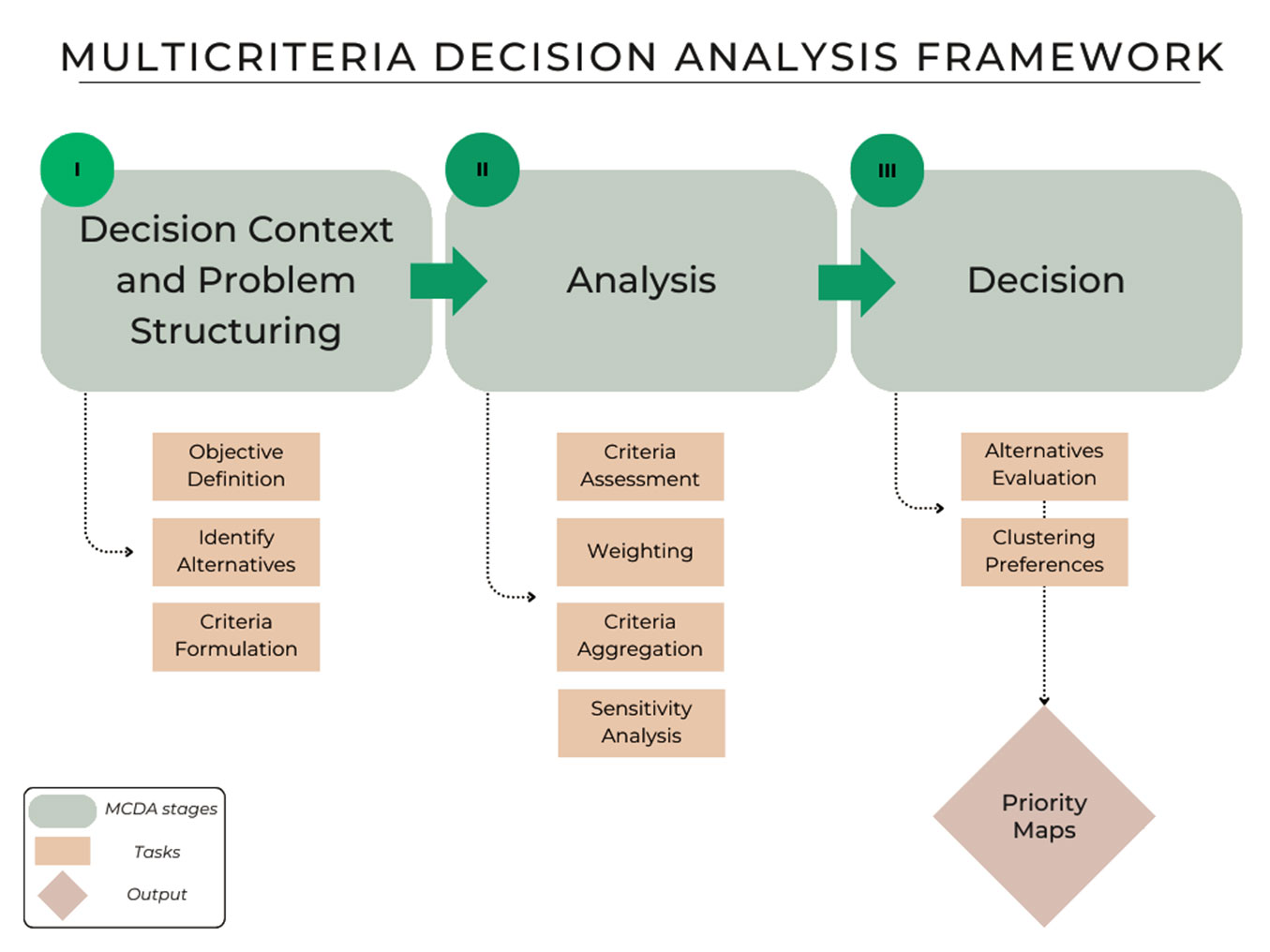
Fig. 1 illustrates the three main stages of the MCDA framework as outlined by Esmail & Geneletti ([30]). The first stage, Decision Context and Problem Structuring, involves defining objectives, identifying alternatives, and establishing evaluation criteria. The second stage, Analysis, assesses the performance of the criteria set, applies weights to represent their relative importance ([76]), aggregates the results, and performs sensitivity analyses to account for uncertainties. The final stage, Decision, integrates these results to rank or cluster the alternatives, supporting a transparent and informed selection process to address the proposed problem.
The following items outline the procedures employed in our literature search and the analysis of the resulting database, with a focus on articles that apply MCDA to the selection or prioritization of sites for forest restoration actions.
Literature search
We considered full articles published in Web of Science® and Scopus® that were retrieved by the following search terms: “forest restoration AND (multicriteria OR decision analysis OR decision support system OR MCDA OR MCDM)”, along with their equivalents in Portuguese and Spanish. These terms were applied to the topics for the Web of Science platform, and to the title, abstract, and keywords for the Scopus platform. We included all papers published between January 2002 and September 2024. Based on 521 papers returned by this search, we selected those that fit our review objective: first, by reading the paper’s abstract and title, narrowing it to 38 papers; and then, by reading the full paper, we reached the final 24 papers evaluated. We excluded studies that reported on commercial tree plantations, those that only partially aligned with our scope and research questions, and those that did not employ MCDA-based approaches for site prioritization.
Data analysis
Through the descriptive analysis, we collected information on (i) the number of published papers, (ii) the number of authors, (iii) timespan, (iv) sources, (v) percentage of international co-authorship, (vi) average age of documents, (vii) annual growth rate, (viii) number of co-authors, and (ix) average number of citations. This analysis was performed using the “bibliometrix” package in R 4.2.1 ([5]). Additionally, we extracted information about the paper’s study areas, allowing us to analyze the countries where the studies were conducted and their corresponding biome according to Olson et al. ([64]).
After data collection, we tabulated and quantified all spatial criteria found in the results. In some cases, it was necessary to standardize specific terms related to the identified spatial criteria. This step was essential because, in several instances, spatial criteria representing the same information were referred to by different names. For example, many spatial criteria are derived from maps based on Euclidean distance to features such as forest patches, drainage networks, urban areas, and roads. In this context, authors such as Uribe et al. ([92]) and Orsi & Geneletti ([65]) refer to a spatial criterion as “distance from forest” or “distance from existing forest”, while others ([94], [85]) use the term “proximity to forest patches” to describe the same criterion. In both cases, the purpose of including this criterion in the decision-making is identical: to prioritize areas closer to forested regions. Therefore, we standardized this criterion as “proximity to forest patches”.
Similarly, interchangeable terms such as “forest fragments” and “forest patches”, or “pluviosity” and “precipitation” were standardized to “forest patches” and “pluviosity”, respectively. Tab. S1 (Supplementary material) presents the various spatial criteria identified in each analyzed article, both in their original and standardized form.
These steps enabled us to systematically categorize the spatial criteria set by thematic context, resulting in nine distinct categories, which are presented below. This categorization groups spatial criteria that share a common thematic focus, as well as those derived from similar data sources or methodologies. It is essential to note that this categorization is didactic, designed to facilitate a more structured and comprehensive analysis of the spatial criteria identified in the reviewed studies. By organizing the criteria in this way, we aim to provide clearer insights into their roles and relevance within the decision-making processes.
Results and discussion
Bibliometric aspects
We identified 24 papers reporting MCDA-based approaches for selecting or prioritizing sites for implementing forest restoration actions. They came from eight different countries (Fig. 2): Brazil (14), Mexico (4), the United States (1), Madagascar (1), China (1), Costa Rica (1), Bolivia (1), and Greece (1), comprising six biomes. The most represented is Tropical and Subtropical Moist Broadleaf Forests (13), followed by Tropical and Subtropical Grasslands, Savannas and Shrublands (4), Tropical and Subtropical Coniferous Forests (2), Tropical and Subtropical Dry Broadleaf Forests (2), Mediterranean Forests, Woodlands and Scrub (2), and Temperate Broadleaf and Mixed Forests with only one published paper (Fig. 2).
Fig. 2 - World distribution of published papers (n = 24) on the MCDA-based approaches to enhance forest restoration actions.
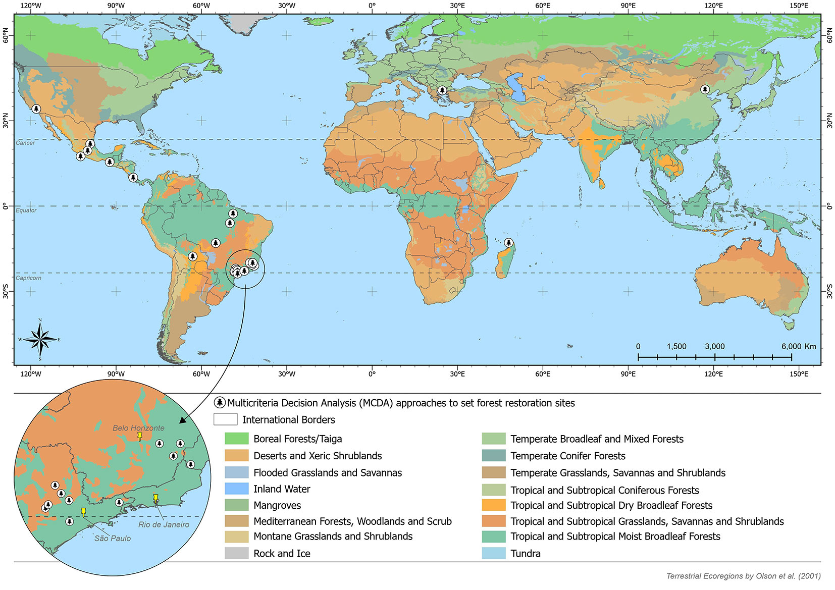
There is a clear predominance of studies conducted in intertropical regions, particularly in Latin America (Fig. 2). According to Brancalion et al. ([13]), tropical forests are recognized as highly threatened biomes and hotspots for scientific advancements in the development of restoration strategies ([10], [47], [75]) and in the understanding of ecological succession processes ([6], [22], [91]). Our results align with these findings, but they also highlight the need for broader geographic dissemination of these methodologies worldwide.
This perspective is consistent with Borda-Niño et al. ([12]), who reviewed studies on drivers of tropical forest recovery and identified a limited representation of such research in Africa and Asia. Although our analysis included publications in Portuguese and Spanish, it is important to highlight that this factor did not bias the results, as only three studies ([80], [81], [24]) were published in Portuguese and one ([16]) in Spanish.
Similarly, Borda-Niño et al. ([12]) identified Brazil and Mexico as the countries with the highest concentration of studies. They attributed this to critical factors, including the availability of data on land-use and land-cover changes, deforestation patterns, and public policies that encourage restoration efforts on both public and private lands. These same factors were highlighted by Uribe et al. ([92]) as essential for structuring decision-making processes in MCDA, particularly regarding the availability of spatialized data.
In Brazil, there is a notable concentration of publications in the southeastern region (Fig. 2), particularly in the states of São Paulo and Minas Gerais. This ecotone region, situated in a transitional zone between the Atlantic Forest and the Brazilian savanna (Cerrado), has been the focus of numerous foundational studies aimed at developing landscape management strategies. These studies encompass a range of topics, including biogeography and systematics, conservation and biodiversity, plant-animal interactions, and population and community dynamics ([56]). Additionally, significant contributions have been made to understanding the spatial patterns of genetic diversity, the impacts of human-induced habitat loss, and the effects of climate change on these ecosystems ([20]).
This region also benefits from the extensive availability of free, high-resolution spatial data, including temporal land-use and land-cover series ([85]), rainfall regimes, topography, and soil properties. Public institutions or non-governmental organizations (NGOs) often generate and disseminate such data, facilitating advanced spatial analyses and modeling. As highlighted by Orsi & Geneletti ([65]) and Uribe et al. ([92]), understanding regional dynamics and having access to spatial data at appropriate spatial and temporal scales are fundamental for implementing MCDA approaches. However, as observed by Colli et al. ([20]) and Marques et al. ([56]), in the Brazilian context, the concentration of publications in the country’s southeastern region is also influenced by socioeconomic factors. This region hosts the most traditional universities and national research centers ([20]), reflecting of the process of institutionalizing science in Brazil ([55]), which benefits from more significant funding compared to institutions located in other parts of the country. This disparity is reflected in the regionalization of studies, highlighting the importance of adequate funding for research groups and graduate programs, particularly those in less privileged regions, such as central and northern Brazil ([20]).
The literature reviewed comprised papers published between 2010 and 2023, despite the search timeframe ranging from 2002 to 2024. This finding emphasizes the pressing need to develop new methodologies that optimize resources for forest restoration, given the growing global interest in this subject and following the establishment of international agreements and commitments, such as the UN Convention on Biological Diversity, the New York Declaration of Forests, and the UN Sustainable Development Goals ([48]). In this context, technological advancements are expected to play a significant role in numerous initiatives, including the transfer, compilation, and dissemination of knowledge, case studies, best practices, lessons learned, and methods for evaluating the success of restoration projects ([43]).
The bibliometric database’s descriptive analysis (Tab. 1) highlights an annual publication growth rate (9.59%), indicating recent advancements in these approaches. Moreover, the substantial number of authors (73) across all publications is contrasted with the low rate of international co-authorship (10%), underscoring the importance of fostering greater collaboration among researchers. Such collaboration is essential to replicate successful prioritization results in diverse environments.
Tab. 1 - Descriptive metrics of the bibliometric data collection.
| Descriptive Metric | Results |
|---|---|
| Papers | 24 |
| Authors | 83 |
| Timespan | 2010-2023 |
| Sources | 20 |
| International Co-Authorship (%) | 4.16 |
| Document Average Age (years) | 5.38 |
| Annual Growth Rate (%) | 8.82 |
| Co-Authors per doc | 3.75 |
| Average Citations per doc | 9.60 |
Our research identified a progression in methodologies for prioritizing forest restoration areas using MCDA approaches shaped by foundational studies. Among the most influential works, Orsi & Geneletti ([65]) presented a pioneering decision-making process that integrated ecological and socioeconomic spatial criteria to address two central questions: (i) “Where should biodiversity be protected?” and (ii) “Where is reforestation likely to succeed?” This study emphasized the importance of a robust theoretical framework on forest succession and restoration ecology alongside georeferenced data at appropriate scales. Challenges such as defining criteria and their relative importance were highlighted, with the incorporation of expert and stakeholder opinions proposed as a solution to enhance accuracy.
Uribe et al. ([92]) advanced the methodology by directly incorporating stakeholder preferences through interviews with academics, government officials, NGOs, and local stakeholders. While this approach yielded actionable outcomes for restoration site selection, the authors acknowledged several limitations, including the challenge of obtaining georeferenced data to meet specific spatial criteria and balancing conflicting stakeholder interests. Vettorazzi & Valente ([97]) further refined the process by integrating participatory techniques ([29]) and the Analytic Hierarchy Process ([76]), reducing subjectivity and ensuring replicability. For instance, their methodology was successfully applied in two distinct watersheds, demonstrating its effectiveness in prioritizing areas for improving water-related ecosystem services. Valente et al. ([94]) and Aguirre-Salado et al. ([2]) also showcased the flexibility of these approaches by adapting them to different contexts, such as a transition zone between the Cerrado and the Atlantic Forest, and the Amazon rainforest, while later Noth & Rinner ([62]) did the same in a region with a semi-arid Mediterranean climate in the United States. These adaptations demonstrated the robustness of MCDA frameworks, as criteria weights could be adjusted to reflect diverse landscape dynamics and local characteristics.
Bibliometric aspects
Among the 24 analyzed papers, we identified 59 distinct spatial criteria applied 138 times. As illustrated in Fig. 3, these 59 spatial criteria were systematically grouped into nine thematic categories. The grouping was based on the thematic focus of each spatial criterion, the authors’ justification for their inclusion in decision-making processes, and the data source and methodology used to process them. Tab. S2 (Supplementary material) provides a detailed overview of the spatial criteria within each thematic category, the frequency of their use, and the studies in which they were applied.
Fig. 3 - Proportional contribution of each spatial criterion group to the overall set of criteria observed in the evaluated decision-making processes.
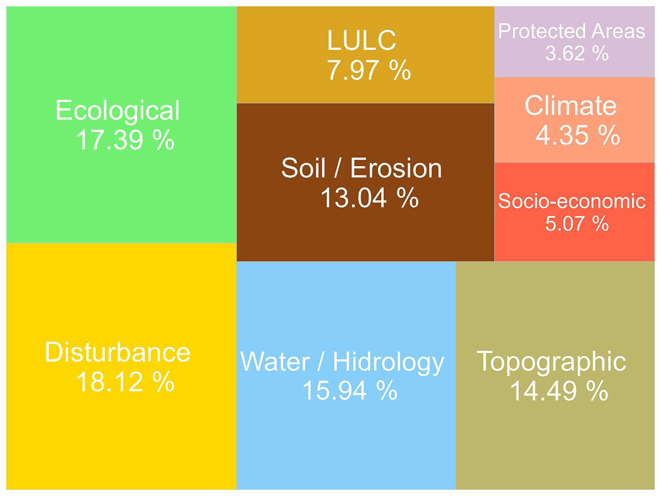
Among the nine identified categories, approximately 80% of the occurrences are concentrated in those related to disturbance (25 occurrences), ecology (24), water and hydrology (22), topography (20), and soil and erosion (18). This distribution underscores two primary considerations. The first is the search for sites that will support the restoration efficiently. This is demonstrated by prioritizing restoration actions away from roads and urban infrastructure ([65], [92], [2], [85]) while favoring proximity to existing forest cover ([94], [50], [21], [62]), aiming to catalyze ecological succession by favoring processes such as colonization and immigration ([99] ) on the restored patches.
The second consideration highlights the critical role that future forest cover will play within the landscape, particularly in managing soil and water resources. Restoration efforts aim to stabilize or prevent erosion processes ([23], [97], [84], [69]), protect stream and river margins to reduce runoff velocity and sediment transport, and improve water quality ([97], [95], [33]) while promoting the recovery of degraded areas ([17]).
Spatial criteria related to disturbance sources were the most frequently employed in the analyzed decision-making processes. These criteria primarily derive from Euclidean distance to landscape elements considered unfavorable for the success of forest restoration actions, with greater distances to these elements resulting in higher prioritization. The spatial criterion “Distance from Roads” is the most utilized, and it was applied in nine cases.
Roads were identified as a significant factor disrupting forest restoration for several reasons. First, their linear configuration in the landscape often splits fragments and isolates habitats, reducing habitat quality and core area size ([85]). Second, roads facilitate human settlement and activities ([26]), acting as conduits for deforestation, selective logging, and wildfires while hindering natural regeneration in surrounding areas ([8]). Furthermore, roads increase the attractiveness of these regions for agricultural expansion due to improved transportation and production flow, posing a direct threat to nearby forest remnants and discouraging the allocation of those sites for restoration initiatives ([49], [26], [85]).
Similarly, eight cases used the spatial criterion “Distance from Urban Areas” to prioritize sites farther from urbanized regions for restoration actions. Proximity to urban areas is widely regarded as a disturbance source, mainly due to the high concentration of human activity in cities and settlements, which are among the primary drivers of pollution, land degradation, and natural resource exploitation ([69]). Forest patches and water resources near urban areas face similar adverse effects as those near roads ([44]).
Other disturbance-related criteria adapted to specific local landscapes include “Distance from Roads and Infrastructure”, which extends the scope of analysis to include mobility and public supply infrastructures ([33]), utilizing Euclidean distance for spatial representation. Additionally, Calvo-Villalobos et al. ([16]) employed the “Infrastructure” criterion, which considers only the presence or absence of such elements in the landscape to formulate restoration alternatives.
It is essential to note that although large-scale restoration efforts are impractical in urban environments ([48]), forests near cities and forest patches integrated into urban environments are highly valued for their ecosystem service provision and contributions to urban well-being. These include climate regulation, recreation opportunities, eco-tourism, air quality improvement, water management, and natural disaster mitigation ([1], [66]). Urban forest restoration and conservation initiatives are gaining prominence as they address the challenge of balancing urban growth with ecological landscape management ([96]). This emerging field emphasizes green spaces, urban parks, and protected area management as critical components of sustainable urban planning ([70]), and such initiatives should be encouraged and further developed.
In three decision-making processes, we identified spatial criteria designed to distance forest restoration actions from agricultural regions. This was achieved through the use of the spatial criterion “Distance from Agricultural Areas” in two instances, spatialized based on Euclidean distance to agricultural patches, and the criterion “Cropland Cover (%)” in one instance, applied at the watershed scale to prioritize sub-basins with a lower proportion of cropland cover ([50]).
According to the authors, the motivation for incorporating these spatial criteria into decision-making processes stems from recognizing that areas near agriculture often face numerous human-induced pressures and are susceptible to land-use alterations ([65]). Additionally, stakeholders consulted in those cases during the spatial criteria selection emphasized the importance of segregating regions designated for agricultural production from those intended for conservation ([65], [92]).
This perspective touches on the ongoing debate in conservation science about “Land Sparing vs. Land Sharing” ([34]). The “Land Sparing” concept advocates for zoning large-scale agricultural production areas and conservation zones as separate entities. At the same time, “Land Sharing” rejects this dichotomy and promotes the integration of agricultural production and conservation ([40], [34]).
Recent trends in conservation research suggest that both approaches offer interdependent, complementary opportunities for forest restoration, highlighting that the balance between them depends on landscape configuration and governance ([57]).
Although biophysical factors less conducive to large-scale agricultural activities, such as high altitudes, steep slopes, and less fertile soils, play a significant role in promoting forest cover expansion ([12]), simply distancing restoration actions from agricultural fields is not an evidence-based practice for ecological landscape management ([40], [57], [7]). Also, this approach may conflict with critical command-and-control mechanisms, such as Brazil’s Native Vegetation Protection Law ([41]), and similar initiatives in countries like Costa Rica ([16]) and Bolivia ([33]), which mandate conservation and restoration on agricultural and private lands.
Still, regarding disturbances, recent studies ([33], [27]) have employed spatial criteria related to wildfire occurrences to guide restoration actions in affected regions. Fernández et al. ([33]) employed the criteria “Fire Occurrence” and “Fire Intensity” using a binary approach, assessing the presence or absence of wildfires and their corresponding intensity levels. In contrast, Dosis et al. ([27]) employed the “Differenced Normalized Burn Ratio” (dNBR) as a continuous variable, where wildfire occurrences are quantified using the dNBR spectral index, and prioritization increases progressively with the burn ratio across the landscape.
The recent application of MCDA approaches to forest restoration in fire-affected regions underscores the critical role of structured decision-making processes in guiding restoration efforts. This approach is particularly essential in the current context of climate change, characterized by rising temperatures and an increasing frequency of wildfires globally ([54], [60], [38]).
The second group of spatial criteria with the highest presence in decision-making processes pertains to ecological criteria, mainly related to habitat patches. It accounts for 24 occurrences and 12 distinct spatial criteria (Tab. S2 in Supplementary material). Despite the relatively large number of unique criteria in this category, 50% of the occurrences correspond to the criterion “Proximity to Forest Patches”.
The authors’ rationale for including this criterion is to promote forest connectivity and gene flow by restoring areas near existing forest cover ([94], [85]). It is also justified by the increase in the probability of seed dispersal from forest patches into restored sites ([84]). Additionally, Lopes et al. ([51]) and Noth & Rinner ([62]) highlight improved soil conditions and a higher water storage capacity in soils near forests, factors that enhance the success of restoration actions.
Borda-Niño et al. ([12]) identified proximity to forest remnants as a biophysical factor that significantly influences forest cover expansion, highlighting its role in triggering regenerative processes, a phenomenon also observed by Precinoto et al. ([68]) when analyzing drivers of forest cover changes in Atlantic Forest watersheds. Studies in the Atlantic Forest demonstrate that proximity to forest patches for seed dispersal and propagule reserve purposes is significant up to a threshold of approximately 600 meters, with this influence decreasing as the distance increases and with forest growth tending to occur in the first 180 meters of distance from older patches ([26]).
In practical terms, incorporating this criterion into the decision-making process prioritizes restoration close to existing forest patch edges, increasing the overall area of those patches ([87]) and also enhancing their shape, reducing the intensity of edge effects ([52]), and enhancing ecological corridors ([79]). However, it is important to note that using “Proximity to Forest Patches” as a spatial criterion in MCDA frameworks requires careful consideration, especially in dynamic and fragmented landscapes.
One effect of fragmentation is that patch distances decrease as the number of patches increases ([31], [89]). While this can be positive for biodiversity when accompanied by adequate habitat coverage ([42], [99]) in prioritizing areas through MCDA, such a criterion often leads to a predominance of high-priority areas across the study region, as patches become increasingly proximate. This outcome can undermine the criterion’s effectiveness in guiding the strategic allocation of restoration efforts.
In this context, Sartori et al. ([81]) and Souza et al. ([85]) narrowed down the prioritization range based on the proximity of forest patches by considering only patches with significant core areas, thereby considerably reducing the number of high-priority areas and optimizing the performance of the spatial criterion in the MCDA context. However, although widely used, conservation strategies that rank the importance of habitat patches by size are not evidence-based ([32]) and overlook the critical importance of small patches for biodiversity conservation and gene flow in the landscape ([71]).
This point touches on another heated debate within the scientific community known as the SLOSS (Single Large or Several Small) debate, which addresses the dilemma between conserving single large (SL) or several small (SS) patches in landscapes worldwide. In examining the SLOSS dilemma, Fahrig et al. ([32]) demonstrate that, although there is no evidence that protecting SL patches is more effective for biodiversity conservation, this approach remains prevalent among conservation agencies and programs. However, the authors also acknowledge that even though there is no evidence for SL > SS as a general principle, this does not necessarily translate into a higher priority for preserving SS over SL, and that other factors, such as landscape configuration and the size of the studied ecosystem, must also be considered in decision-making.
Despite the ongoing debate, Riva et al. ([72]) state that protecting as much native habitat as possible is key to safeguarding biodiversity. This requires protecting and restoring both the remaining large native ecosystems and the many small native patches in working landscapes. Above all, habitat patches must be functionally connected to ensure access to sufficient and complementary resources, reduce the risk of population extinction, and facilitate recolonization ([72]).
Regarding this, more sophisticated strategies are emerging to incorporate spatial criteria that promote biodiversity into forest restoration decision-making processes. For instance, Cavalcante et al. ([17]) utilized spatial criteria based on surfaces generated by modeling species’ potential distribution and spatial connectivity derived from an approach grounded in electronic circuit theory applied to ecology.
MCDA-based approaches to forest restoration can benefit from incorporating maps generated using landscape ecology metrics informed by graph theory. These maps effectively link landscape patterns with functional ecological processes ([35], [46]). Although not explicitly employing an MCDA-based framework, Salazar et al. ([77]) prioritized areas for forest restoration in the Brazilian Caatinga through analyses of landscape ecology metrics based on graph theory. Similarly, Tambosi et al. ([88]) developed a framework to optimize biodiversity restoration efforts using a graph-based approach that integrates habitat quantity and landscape connectivity metrics. Additionally, Antongiovanni et al. ([4]), using similar concepts, prioritized restoration areas also in the Brazilian Caatinga, considering landscape resilience, connectivity, and biodiversity value.
The significant prevalence of criteria categorized as ecological reflects the intention of decision-makers to prioritize sites in a manner that leverages conditions capable of catalyzing regenerative processes, capitalizing on colonization credits in regions that have experienced habitat loss, enhancing the shape and structure of existing forest patches, reducing-edge effects on forest remnants, and facilitating ecological connectivity. However, the predominance of proximity to forest patches as a spatial criterion, even with its low efficiency in fragmented and dynamic landscapes, highlights the limited effort to optimize the selection of spatial criteria, a weakness of MCDA approaches in the context of nature conservation, as reported by Esmail & Geneletti ([30]). Therefore, we advocate for greater integration of this research niche with more robust ecological analyses and modeling to develop spatial criteria that enhance the functional connectivity of habitat areas.
Regarding water-related criteria, 59.09% of instances involved the spatial criterion of “proximity to drainage network”. It integrated the decision process 13 times, focusing on the protective role of riparian vegetation in preserving soil and enhancing water availability in watersheds ([58], [1]).
From an ecological perspective, implementing forest restoration near drainage networks is advantageous because water flow disperses nutrients, and riparian buffers can enrich them ([12], [83]). However, as with most criteria based on Euclidean distance, it is essential to clearly understand the drainage pattern within the study area.
Spatializing the Euclidean distance without considering the drainage pattern can result in a significant number of pixels with a high priority on the criterion map, particularly in regions with a high concentration of small streams. This makes the prioritization map biased towards such a factor, even when the criteria weights or the aggregation MCDA algorithm are changed, as reported by Valente & Vettorazzi ([93]) and Vettorazzi & Valente ([97]).
In this context, certain strategies have been observed to mitigate or prevent issues related to distance metrics. For example, some studies suggest considering only proximity to springs ([95]) or prioritizing sites with lower surface-water presence ([50]). Souza et al. ([85]) and Li et al. ([50]) considered the qualitative aspects of the drainage network, prioritizing regions based on water quality and potential aquifer contamination.
Other approaches that have the potential to represent the semantics behind spatial criteria in this category are those based on variables derived from indices used in morphometric and hydrological characterizations of the landscape, among which we can mention a high potential for drainage density maps, spatialized from the Kernel density function of the drainage channels ([11]). When spatialized, the raster resulting from this metric indicates in each cell the extent of the drainage channels in km·km-2 continuously, making it an easy-to-interpret and promising approach for implementation in MCDA-based analyses.
Topographic-related criteria represent another highly valued group, with 20 occurrences, dominated by the “Slope” criterion, which accounted for 70% of observations. The inclusion of slope in decision-making processes stems from two interrelated factors. First, it addresses erosion prevention, as steeper slopes are more vulnerable to erosive processes, making these areas a priority for restoration ([95]). Second, decision-makers often assume that flatter areas are more suitable for human activities. In contrast, steeper slopes are less favorable for such uses and more prone to erosion, thus making them better candidates for conservation and restoration efforts ([21]).
Empirical studies analyzing forest regrowth and deforestation dynamics support this rationale, identifying slope as a critical factor influencing increases in forest cover, particularly following the abandonment of agriculturally marginal, steep regions ([15], [12]). Similarly, Precinoto et al. ([68]) observed that steep slopes are conducive to forest regrowth, whereas flat or uniformly sloped areas are more susceptible to deforestation.
Sloan et al. ([86]) emphasize the socioeconomic implications of slope within landscapes, reflecting its role in shaping human occupation patterns. This perspective is corroborated by Aide et al. ([3]) and Sánchez-Cuervo & Aide ([78]), who observed increased rural emigration from sloped regions as agricultural activities intensified in Latin America and the Caribbean. Thus, slope serves multiple purposes in forest restoration decision-making processes. It facilitates soil protection through forest growth while also presenting an opportunity to promote conservation and restoration initiatives. Additionally, its ease of derivation and interpretation, along with its continuous spatial representation, make it an ideal criterion for application in MCDA-based approaches.
In addition to slope, other topographic-related criteria, such as the Topographic Wetness Index (TWI), Compound Topographic Index (CTI), aspect, and elevation, were employed in specific instances. The TWI and CTI focus on hydrologically sensitive areas by modeling surface runoff and soil moisture distribution ([11], [18], [27]), while elevation prioritizes headwater regions of watersheds ([33]). Aspect was used similarly to slope, addressing the impact of terrain orientation on ecological processes.
Another criterion is “Insolation”, which prioritizes areas based on sunlight exposure, a factor critical for natural regeneration and secondary succession ([26], [68]). Typically derived from DEM data, insolation currently excludes terrain not exposed to sunlight, without quantifying solar radiation. However, calculating solar radiation income ([36]) offers great potential for more robust spatial analyses. Overall, moderate solar radiation promotes species recruitment, although areas with higher radiation may be prioritized in specific contexts, such as forest fire mitigation ([68]).
Spatial criteria related to the Soil/Erosion group were among the most frequently employed in the analyzed studies, with 18 occurrences and six distinct variations. This group addressed various pedological characteristics, with a preference for conservationist and protective approaches to prevent or mitigate erosion through forest restoration. The preference for these criteria was more evenly distributed than other categories, with the spatial criterion “Soil Erodibility” being the most widely adopted, accounting for 33.33% of occurrences in this group. Its choice is attributed to its ability to represent the inherent characteristics of different soil types and their collective influence on factors such as moisture retention, aggregation, surface crusting, and the availability of loose, erodible materials ([95]). This allows for the identification of areas with high erodibility values, which are directly linked to regions most sensitive to runoff within watersheds, as highlighted by Vettorazzi & Valente ([97]) and Lopes et al. ([51]).
The spatial criterion “Erosion Risk” was employed in 22.22% of cases, focusing on preventing and mitigating erosion in watersheds. However, the representation of this criterion varies across studies. For instance, Rajaonarivelo & Williams ([69]) spatialized erosion risk using a map derived from the Revised Universal Soil Loss Equations (RUSLE). In contrast, Orsi & Geneletti ([65]) calculated it based on Land Use and Land Cover (LULC) maps, incorporating slope, rainfall, and soil class. Silva & Vieira ([84]) applied the “Natural Vulnerability to Erosion” criterion, which integrates multiple factors, including slope, vegetation cover, land use, pedology, geology, and geomorphology.
In addition to erosion-related criteria, researchers have also focused on soil properties conducive to the establishment of native vegetation. This was primarily reflected in the “Soil Class” criterion, which accounted for 22.22% of occurrences. Studies by Cruz-Bello & Sotelo-Ruiz ([23]), De Almeida et al. ([25], [24]), and Dosis et al. ([27]) emphasized the importance of chemical properties and soil fertility in supporting restoration efforts. These concerns align with the findings by De Rezende et al. ([26]), who identified low soil fertility as a significant barrier to forest regeneration, presenting a practical challenge to restoration initiatives.
Criteria representing localized phenomena, such as erosion ([23], [85]) or areas with bare soil ([2]), received comparatively less attention. This is primarily due to their limited spatial coverage and applicability, as these characteristics are often context-dependent and binary.
In contrast with the previous categories, spatial criteria associated with LULC (11), socioeconomic factors (7), climatic variables (6), and protected areas (5) were utilized less frequently. Although LULC data are essential for creating derivative maps, such as distance maps to disturbances (e.g., urban developments, infrastructure, and agricultural activities), as well as proximity analyses concerning forest or hydrographic networks, LULC criteria were incorporated in fewer than half of the evaluated decision-making processes. This suggests that while LULC data are critical for generating secondary spatial criteria, they are often not directly integrated into decision-making. However, certain LULC classes are prioritized in some situations, such as pastures ([95]) and degraded areas ([69]). Alternatively, preferences are assigned to all non-restrictive LULC classes, yielding a criterion map with distinct priority scores for each LULC class ([21]). “Land Use Suitability” criteria were utilized and justified by the more precise information obtained compared to traditional LULC maps. It incorporates additional factors, including soil and slope aspects, in addition to LULC ([97]).
Turning to the other LULC-related spatial criteria, known as “Potential Land Cover for Passive Restoration,” “Potential for Natural Regeneration,” and “Probability of LULC Conversion”, their names reflect concepts of significant interest among specialists and decision-makers. These concepts align with one of the primary goals of the decision-making process, such as identifying areas conducive to passive restoration, or, more specifically, natural regeneration. However, these criteria are currently in a preliminary stage of spatial representation and do not fully capture the concept motivating their inclusion in decision-making. They are derived from the simple rating of different land uses ([84]), models primarily based on the distance between forest patches ([17]), and Markov chain models ([16]).
Predicting where and how forest regeneration occurs remains a persistent issue in restoration science ([82]). Consequently, a broad spectrum of studies has been undertaken to understand the factors influencing natural regeneration. These studies are crucial for making informed choices regarding the spatial criteria evaluated in this review ([26], [19], [12], [67], [82]).
Although socioeconomic criteria are frequently emphasized as essential for informed decision-making ([65], [30]), their integration often faces challenges due to the lack of spatially explicit and temporally consistent data, as well as practical difficulties in spatialization ([92]). Notably, only a few studies, such as those by Uribe et al. ([92]), Li et al. ([50]), and Fernández et al. ([33]), successfully incorporated these criteria. In contrast, most other articles, lacking robust socioeconomic data, primarily considered human activities indirectly through other spatial criteria groups, particularly those related to disturbances, LULC, and protected areas.
The socioeconomic dimension, however, plays a critical role in the success of forest restoration initiatives, particularly in contexts characterized by rural exodus and the abandonment of previously cultivated lands. These processes are among the primary drivers of forest regrowth or the availability of areas suitable for restoration ([19], [15], [12]). Thus, one of the key challenges in MCDA approaches aimed at forest restoration and nature conservancy in general ([30]) lies in effectively representing the socioeconomic component as a spatial criterion. This requires reliable socioeconomic data and consistent methodologies for spatializing this variable.
Climate-related criteria were considered on only six occasions (Tab. S2 in Supplementary material), with rainfall consistently identified as the variable of interest. While understanding rainfall patterns is essential for planning field operations and selecting appropriate species, the limited attention to these criteria in decision-making processes can be attributed to two main factors. First, the availability of spatial and temporal data is often insufficient, particularly in regions with sparse monitoring station coverage ([61]). Second, the scale at which most MCDA analyses are conducted, typically at the watershed level, often minimizes the variability in rainfall, rendering its influence less significant in the overall assessment ([63]). However, recent advancements in data availability, such as the Climate Hazards Group InfraRed Precipitation with Stations (CHIRPS) project ([37]), which provides daily rainfall estimates at a spatial resolution of 500 meters, offer promising opportunities to overcome these limitations and enhance the integration of climate-related criteria into forest restoration decision-making frameworks ([45], [73]).
The authors primarily (in four instances) employed simple annual rainfall averages obtained from either rain gauge stations ([23]) or meteorological satellites ([25], [24], [33]), spatialized using interpolation and kriging methods. The remaining two studies, which incorporated climate-related criteria, utilized distinct approaches. One employed “Rain Erosivity”, derived from the R-factor of the USLE model, using rainfall data from meteorological stations ([97]). The other study introduced a criterion termed “Annual Average Precipitation and Potential Evapotranspiration Difference” ([18]). This criterion, in addition to rainfall data, integrates evapotranspiration estimates modeled via remote sensing. According to the authors, this approach is justified by the premise that water production is optimized in areas with higher water input (greater precipitation depth) and lower water consumption (reduced evapotranspiration depth) in a context where the main restoration objective is to increase the basin’s streamflow.
Finally, the criteria group with the lowest representation in the evaluated decision-making processes was related to protected areas, which were employed in only five instances. In three cases ([16], [21], [33]), the boundaries of protected areas were used as prioritization criteria, assigning higher priority within their limits and lower priority outside them. In one instance ([65]), proximity to protected areas was considered and spatialized using Euclidean distance. In another instance ([84]), the selected criterion was the forest cover deficit within protected areas, prioritizing areas within their boundaries but balancing prioritization based on the level of forest deficit.
Despite the undeniable importance of protected areas for forest conservation and restoration, the low adherence to this criterion group can be attributed to the context-dependent nature of these areas. Their application requires the presence of protected areas within the study regions. Additionally, even in regions where protected areas are prominent in the landscape, often due to legal requirements, as in Brazil (the country with the highest number of studies evaluated here), protected areas are frequently represented by other spatial criteria. Two of the most representative categories of protected areas under Brazilian legislation are associated with riparian vegetation (mandating native vegetation along riverbanks, lakes, and springs, with buffer zones varying based on factors like watercourse width) and slope (areas with slopes exceeding 45° are classified as protected, while those between 25° and 45° are considered restricted-use areas). Spatial criteria commonly used, such as proximity to watercourses and slope, already address these requirements, rendering their explicit inclusion redundant in decision-making processes and, therefore, often excluded in such cases.
Conclusions
This systematic review underscores the critical role of spatial criteria in MCDA-based approaches for prioritizing forest restoration sites. Identifying 59 spatial criteria, categorized into nine thematic groups, highlights the diversity of environmental, ecological, and socioeconomic factors shaping restoration planning. However, our findings reveal an intense geographic concentration of studies in tropical regions, particularly in Latin America, indicating the need for broader application of these methodologies across diverse biomes.
A clear pattern emerges when selecting spatial criteria that focus on disturbances, ecological processes, hydrology, soil and erosion, and topography. In contrast, criteria related to land use and land cover (LULC), socioeconomic aspects, climate, and protected areas remain underrepresented. This suggests that while restoration planning commonly prioritizes biophysical and ecological factors, there is a gap in the explicit integration of socioeconomic and policy-driven criteria, which are fundamental for ensuring long-term restoration success.
The selection of spatial criteria should accurately represent the landscape’s ecological and socioeconomic dynamics. This requires systematically evaluating habitat connectivity, forest fragmentation, hydrological processes, erosion risk, and anthropogenic pressures, among other landscape attributes. The effectiveness of MCDA-based approaches depends on the semantic precision of spatial criteria, ensuring that each criterion is conceptually relevant and methodologically robust in its representation.
Future research should focus on standardizing methods, protocols, and variables to enhance comparability across studies rather than expanding the number of criteria. Establishing standard guidelines for selecting and weighting spatial criteria will strengthen the reliability of MCDA applications, enabling more consistent and scalable restoration planning across diverse ecological and socio-political contexts.
Acknowledgments
We are grateful to Drs. Lenore Fahrig, Joseph Bennett, and Adriana Cavalieri Sais for their valuable contributions during the early stages of this research’s conception.
The idea for the paper was conceived by MVM and RAV. MVM performed the literature search, analyzed the data, and wrote the first draft of the manuscript. RAV critically revised the work. Both authors read and approved the final manuscript.
This study was partly financed by the Coordenação de Aperfeiçoamento de Pessoal de Nível Superior (CAPES), Brazil, Finance Code 001.
References
CrossRef | Gscholar
CrossRef | Gscholar
CrossRef | Gscholar
CrossRef | Gscholar
CrossRef | Gscholar
CrossRef | Gscholar
CrossRef | Gscholar
Gscholar
CrossRef | Gscholar
CrossRef | Gscholar
CrossRef | Gscholar
CrossRef | Gscholar
CrossRef | Gscholar
CrossRef | Gscholar
CrossRef | Gscholar
Authors’ Info
Authors’ Affiliation
Roberta Averna Valente 0000-0001-7273-7042
Department of Environmental Sciences, Center for Science and Technologies for Sustainability - CCTS, Federal University of São Carlos, Sorocaba Campus, João Leme dos Santos Highway, Km 110, Sorocaba, SP (Brazil)
Corresponding author
Paper Info
Citation
Morales MV, Valente RA (2026). The role of spatial criteria in enhancing forest restoration actions: a systematic review. iForest 19: 157-167. - doi: 10.3832/ifor4624-018
Academic Editor
Raffaele Lafortezza
Paper history
Received: Apr 17, 2024
Accepted: Oct 30, 2025
First online: May 11, 2026
Publication Date: Jun 30, 2026
Publication Time: 6.43 months
Copyright Information
© SISEF - The Italian Society of Silviculture and Forest Ecology 2026
Open Access
This article is distributed under the terms of the Creative Commons Attribution-Non Commercial 4.0 International (https://creativecommons.org/licenses/by-nc/4.0/), which permits unrestricted use, distribution, and reproduction in any medium, provided you give appropriate credit to the original author(s) and the source, provide a link to the Creative Commons license, and indicate if changes were made.

Web Metrics
Breakdown by View Type
Article Usage
Total Article Views: 1691
(from publication date up to now)
Breakdown by View Type
HTML Page Views: 239
Abstract Page Views: 1042
PDF Downloads: 364
Citation/Reference Downloads: 0
XML Downloads: 46
Web Metrics
Days since publication: 47
Overall contacts: 1691
Avg. contacts per week: 251.85
Article Citations
Article citations are based on data periodically collected from the Clarivate Web of Science web site
(last update: Mar 2025)
(No citations were found up to date. Please come back later)
Publication Metrics
by Dimensions ©
Articles citing this article
List of the papers citing this article based on CrossRef Cited-by.
Related Contents
iForest Similar Articles
Research Articles
Effect of restoration methods on natural regeneration in the Brazilian Atlantic Forest
vol. 18, pp. 23-29 (online: 15 February 2025)
Research Articles
Can the dynamics of forest restoration reduce landscape fragmentation in the Atlantic forest?
vol. 18, pp. 61-68 (online: 04 April 2025)
Research Articles
Nutrient cycling indicators in different models of successional groups and spacing for forest restoration
vol. 19, pp. 61-68 (online: 23 February 2026)
Research Articles
Three prescribed fire regimes on the restoration of flooded savannah grasslands under encroachment of Vochysia divergens Pohl, Pantanal, Brazil
vol. 17, pp. 165-171 (online: 17 June 2024)
Review Papers
Shaping the multifunctional tree: the use of Salicaceae in environmental restoration
vol. 6, pp. 37-47 (online: 21 January 2013)
Research Articles
Outplanting performance of three provenances of Quillaja saponaria Mol. established in a Mediterranean drought-prone site and grown in different container size
vol. 13, pp. 33-40 (online: 21 January 2020)
Research Articles
Method for classifying sites to Atlantic Rainforest restoration aiming to increase basin’s streamflows
vol. 14, pp. 86-94 (online: 19 February 2021)
Research Articles
Post-fire recovery of the plant community in Pinus brutia forests: active vs. indirect restoration techniques after salvage logging
vol. 11, pp. 635-642 (online: 04 October 2018)
Research Articles
Managing invasive tree stumps in the restoration of legacy chestnut orchards
vol. 18, pp. 350-356 (online: 30 November 2025)
Research Articles
Tropical seedling performance under drought: a functional trait approach for species selection in restoration
vol. 19, pp. 9-17 (online: 10 January 2026)
iForest Database Search
Search By Author
Search By Keyword
Google Scholar Search
Citing Articles
Search By Author
Search By Keywords
PubMed Search
Search By Author
Search By Keyword


