Estimation of above-ground biomass using machine learning approaches with InSAR and LiDAR data in tropical peat swamp forest of Brunei Darussalam
Elaheh Zadbagher (1), Aycan Murat Marangoz (1) , Kazimierz Becek (2)
iForest - Biogeosciences and Forestry, Volume 17, Issue 3, Pages 172-179 (2024)
doi: https://doi.org/10.3832/ifor4434-017
Published: Jun 17, 2024 - Copyright © 2024 SISEF
Research Articles
Abstract
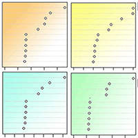
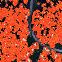
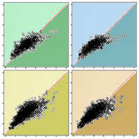
Forest above-ground biomass (AGB) is one of the critical measures of forest resources. Therefore, it is crucial to identify a reliable method to estimate the AGB, especially in the tropics, where forest ecosystems are exposed to several depleting factors, including deforestation, climate change and replacing natural forests with palm oil tree plantations. We investigated the digital elevation data over the forest and uses an artificial intelligence-based approach to develop a method for quick and cost-effective assessment of the AGB. The study was conducted in the tropical peatland rainforest of Brunei Darussalam. The Shuttle Radar Topography Mission (SRTM) elevation data product and Light Detection and Ranging (LiDAR) digital elevation data were used. A linear regression (LR) model and three different machine learning (ML) algorithms, i.e., Random Forest (RF), Artificial Neural Network (ANN) and Support Vector Machines (SVM), were tested and compared. As model inputs, the SRTM elevation and distance from the peat dome’s center, a feature of a peatland swamp forest, were used. ML methods were trained on the samples taken from the LiDAR elevations. The validation results showed that the SVM was the best method to predict AGB in the study area with R2 = 0.70, RMSE = 83.65 Mg ha-1, and MAE = 74.43 Mg ha-1, which in relative terms corresponds to approximately 6% of the AGB of the forest of interests. This study demonstrated the potential of ML algorithms in AGB estimation based on canopy height derived from the InSAR-based DEM in tropical forests.
Keywords
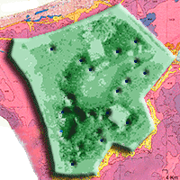
Above-Ground Biomass, Machine Learning, Tropical Forest, InSAR, Badas Peatland Forest
Authors’ Info
Authors’ address
Aycan Murat Marangoz 0000-0003-4409-6000
Geomatics Engineering Department, Zonguldak Bulent Ecevit University, Zonguldak (Turkey)
Faculty of Geoengineering, Mining, and Geology, Wroclaw University of Science and Technology, Wroclaw (Poland)
Corresponding author
Paper Info
Citation
Zadbagher E, Marangoz AM, Becek K (2024). Estimation of above-ground biomass using machine learning approaches with InSAR and LiDAR data in tropical peat swamp forest of Brunei Darussalam. iForest 17: 172-179. - doi: 10.3832/ifor4434-017
Academic Editor
Carlotta Ferrara
Paper history
Received: Jul 22, 2023
Accepted: Mar 05, 2024
First online: Jun 17, 2024
Publication Date: Jun 30, 2024
Publication Time: 3.47 months
Copyright Information
© SISEF - The Italian Society of Silviculture and Forest Ecology 2024
Open Access
This article is distributed under the terms of the Creative Commons Attribution-Non Commercial 4.0 International (https://creativecommons.org/licenses/by-nc/4.0/), which permits unrestricted use, distribution, and reproduction in any medium, provided you give appropriate credit to the original author(s) and the source, provide a link to the Creative Commons license, and indicate if changes were made.

Web Metrics
Breakdown by View Type
Article Usage
Total Article Views: 24687
(from publication date up to now)
Breakdown by View Type
HTML Page Views: 13421
Abstract Page Views: 7400
PDF Downloads: 3463
Citation/Reference Downloads: 10
XML Downloads: 393
Web Metrics
Days since publication: 775
Overall contacts: 24687
Avg. contacts per week: 222.98
Citation Metrics
Article Citations
Article citations are based on data periodically collected from the Clarivate Web of Science web site
(last update: Jul 2026)
Total number of cites (since 2024): 10
Average cites per year: 3.33
Publication Metrics
by Dimensions ©
Articles citing this article
List of the papers citing this article based on CrossRef Cited-by.
References
Brunei forest resources and strategic planning study, Final report: The Forest Resources of Negara Brunei Darussalam. The Government of His Majesty the Sultan and Yang Di Pertuan of Negara Brunei Darussalam, vol. 1, Brunei Darussalam.
Gscholar
Estimation of mangrove forest above-ground biomass using multispectral bands, vegetation indices and biophysical variables derived from optical satellite imageries: rapideye, planetscope and sentinel-2. ISPRS Annals of Photogrammetry, Remote Sensing and Spatial Information Sciences 4 (3): 29-36.
CrossRef | Gscholar
Forest biomass and carbon stock quantification using airborne LiDAR data: a case study over Huntington Wildlife Forest in the Adirondack Park. IEEE Journal of Selected Topics in Applied Earth Observations and Remote Sensing 7 (7): 3143-3156.
CrossRef | Gscholar
Random forest regression modeling for forest above-ground biomass estimation using RISAT-1 PolSAR and terrestrial LiDAR data. In: Proceedings of the Conference “SPIE Asia-Pacific Remote Sensing - Lidar Remote Sensing for Environmental Monitoring XV”. New Delhi (India) 4-7 Apr 2016. International Society for Optics and Photonics, vol. 9879, pp. 98790Q.
CrossRef | Gscholar
Estimating mangrove above-ground biomass using extreme gradient boosting decision trees algorithm with fused sentinel-2 and ALOS-2 PALSAR-2 data in Can Gio biosphere reserve, Vietnam. Remote Sensing 12(5): 777.
CrossRef | Gscholar
A machine-learning approach to PolInSAR and LiDAR data fusion for improved tropical forest canopy height estimation using NASA AfriSAR Campaign data. IEEE Journal of Selected Topics in Applied Earth Observations and Remote Sensing 11 (10): 3453-3463.
CrossRef | Gscholar
Comparison of statistical modeling approaches for estimating tropical forest above-ground biomass stock and reporting their changes in low-intensity logging areas using multi-temporal LiDAR data. Remote Sensing 12 (9): 1498.
CrossRef | Gscholar
Improving accuracy estimation of forest above-ground biomass based on incorporation of ALOS-2 PALSAR-2 and Sentinel-2A imagery and machine learning: A case study of the Hyrcanian forest area (Iran). Remote Sensing 10 (2): 172.
CrossRef | Gscholar
Related Content
Ansari N, Moradi M, Taghizadeh-Mehrjardi R
Vol. 19, pp. 186-194 (online: Jun 2026)

Duarte-Carvajalino JM, Paramo-Alvarez M, Ramos-Calderón PF, González-Orozco CE
Vol. 14, pp. 517-521 (online: Dec 2021)
Maesano M, Santopuoli G, Moresi FV, Matteucci G, Lasserre B, Scarascia Mugnozza G
Vol. 15, pp. 451-457 (online: Dec 2022)

Diamantopoulou MJ, Çömez A, Özçelik R, Güner ST
Vol. 17, pp. 19-28 (online: Feb 2024)

Göltas M, Ayberk H, Kücük O
Vol. 17, pp. 10-18 (online: Feb 2024)
Malek S, Miglietta F, Gobakken T, Næsset E, Gianelle D, Dalponte M
Vol. 12, pp. 323-329 (online: Jun 2019)
Padmakumar B, Sreekanth NP, Shanthiprabha V, Paul J, Sreedharan K, Augustine T, Jayasooryan KK, Rameshan M, Mohan M, Ramasamy EV, Thomas AP
Vol. 11, pp. 534-541 (online: Aug 2018)
Hernández-Ramos A, Valdez-Lazalde JR, De Los Santos-Posadas HM, Reyes-Hernández VJ, López-Serrano PM, Cano-Pineda A, Flores-Magdaleno H
Vol. 18, pp. 357-365 (online: Dec 2025)
Mohanraj R, Saravanan J, Dhanakumar S
Vol. 4, pp. 61-65 (online: Apr 2011)

Vijayanathan J, Ishak MF, Parlan I, Omar H, Osumanu Haruna A, Lion M, Hassan MG, Jong RM, Samah AKA
Vol. 14, pp. 362-369 (online: Aug 2021)


