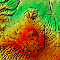
High resolution biomass mapping in tropical forests with LiDAR-derived Digital Models: Poás Volcano National Park (Costa Rica)
Alfredo Fernández-Landa (1) , José Antonio Navarro (1-2), Sonia Condés (2), Nur Algeet-Abarquero (1-3), Miguel Marchamalo (3)
iForest - Biogeosciences and Forestry, Volume 10, Issue 1, Pages 259-266 (2017)
doi: https://doi.org/10.3832/ifor1744-009
Published: Feb 23, 2017 - Copyright © 2017 SISEF
Research Articles
Abstract
Tropical forests play a key role in global carbon cycle. Reducing Emissions from Deforestation and forest Degradation (REDD+) program requires reliable mechanisms for Monitoring, Reporting and Verification (MRV). In this regard, new methods must be developed using updated technologies to assess carbon stocks. The combination of LiDAR technology and in situ forest networks allows the estimation of biomass with high resolution in low data environments, such as tropical countries. However, the evaluation of current LiDAR methods of biomass inventory, and the development of new methodologies to reduce uncertainty and increase accuracy, is still needed. Our aim is to evaluate new methodologies of spatially explicit LiDAR biomass inventories based on local and general plot-aggregate allometry. For this purpose, 25 field plots were inventoried, covering the structural and ecological variability of Poás Volcano National Park (Costa Rica). Important differences were detected in the estimation of aboveground biomass (92.74 t ha-1 considering the mean value of plot sample) depending on the chosen tree allometry. We validated the general aboveground biomass plot-aggregate allometry proposed by Asner & Mascaro (2014) in our study area, and we fitted two specific models for Poás forests. Both locals and general models depend on LiDAR top-of-canopy height (TCH), basal area (BA) and wood density. Small deviations in the wood density plot sample (0.60 ± 0.05) indicated that a single wood density constant value could be used throughout the study area. A BA-TCH origin forced linear model was fitted to estimate basal area, as suggested by the general methodology. Poás forest has a larger biomass density for the same THC compared to the rest of the forests previously studied, and shows that the BA-TCH relationship might have different trends in each life zone. Our results confirm that the general plot-aggregate methodology can be easily and reliably applied as aboveground biomass in a new area could be estimated by only measuring BA in field plots to obtain a local BA-TCH regression. For both local and general methods, the estimation of BA is critical. Therefore, the definition of precise basal area field measurement procedures is decisive to achieve reliable results in future studies.
Keywords
Carbon, Remote Sensing, REDD, LiDAR, Plot-level Allometry, Biomass, Basal Area
Authors’ Info
Authors’ address
José Antonio Navarro
Nur Algeet-Abarquero
Agresta Soc. Coop, C/ Duque de Fernán Núñez 2, Madrid 28012 (Spain)
Sonia Condés
Dept. Natural Systems and Resources, Technical University of Madrid. School of Forestry, Ciudad Universitaria, Madrid 28040 (Spain)
Miguel Marchamalo
Dept. of Land Morphology and Engineering, Technical University of Madrid, Ciudad Universitaria, Madrid 28040 (Spain)
Corresponding author
Paper Info
Citation
Fernández-Landa A, Navarro JA, Condés S, Algeet-Abarquero N, Marchamalo M (2017). High resolution biomass mapping in tropical forests with LiDAR-derived Digital Models: Poás Volcano National Park (Costa Rica). iForest 10: 259-266. - doi: 10.3832/ifor1744-009
Academic Editor
Davide Travaglini
Paper history
Received: Jun 18, 2015
Accepted: Oct 20, 2016
First online: Feb 23, 2017
Publication Date: Feb 28, 2017
Publication Time: 4.20 months
Copyright Information
© SISEF - The Italian Society of Silviculture and Forest Ecology 2017
Open Access
This article is distributed under the terms of the Creative Commons Attribution-Non Commercial 4.0 International (https://creativecommons.org/licenses/by-nc/4.0/), which permits unrestricted use, distribution, and reproduction in any medium, provided you give appropriate credit to the original author(s) and the source, provide a link to the Creative Commons license, and indicate if changes were made.

Web Metrics
Breakdown by View Type
Article Usage
Total Article Views: 54651
(from publication date up to now)
Breakdown by View Type
HTML Page Views: 44566
Abstract Page Views: 4660
PDF Downloads: 3979
Citation/Reference Downloads: 27
XML Downloads: 1419
Web Metrics
Days since publication: 3411
Overall contacts: 54651
Avg. contacts per week: 112.15
Citation Metrics
Article Citations
Article citations are based on data periodically collected from the Clarivate Web of Science web site
(last update: Mar 2025)
Total number of cites (since 2017): 3
Average cites per year: 0.33
Publication Metrics
by Dimensions ©
Articles citing this article
List of the papers citing this article based on CrossRef Cited-by.
References
High-resolution mapping of forest carbon stocks in the Colombian Amazon. Biogeosciences Discussions 9 (3): 2683-2696.
CrossRef | Gscholar
High-fidelity national carbon mapping for resource management and REDD+. Carbon balance and management 8 (1): 1-14.
CrossRef | Gscholar
Mapa ecológico de Costa Rica (Zonas de Vida), según el sistema de clasificación de zonas de vida del mundo de L.R. Holdridge), Escala 1: 750 000. [Ecological map of Costa Rica (Life Zones) according to the classification system of Holdridge life zones in the world, Scale 1:750.000]. Centro Científico Tropical, San José, Costa Rica. [in Spanish]
Gscholar
Tree allometry and improved estimation of carbon stocks and balance in tropical forests. Oecologia 145 (1): 87-99.
CrossRef | Gscholar
Net primary productivity allocation and cycling of carbon along a tropical forest elevational transect in the Peruvian Andes. Global Change Biology 16 (12): 3176-3192.
CrossRef | Gscholar
Orientación sobre las buenas prácticas para uso de la tierra, cambio de uso de la tierra y silvicultura [Good practices guidance on land use, land use change and silviculture]. Programa del IPCC sobre inventarios nacionales de gases de efecto invernadero. IPCC, Geneve, Switzerland, pp. 628. [In Spanish]
Gscholar
Contribution of Working Groups I, II and III to the Fourth Assessment Report of the Intergovernmental Panel on Climate Change: Synthesis Report (Pachauri RK, Reisinger A eds). IPCC, Geneva, Switzerland, pp. 104.
Gscholar
Propuesta para la preparación de readiness R-PP Costa Rica [Costa Rica readiness preparation proposal]. Forest Carbon Partnership Facility, Ministerio de Ambiente, Energía y Telecomunicaciones (MINAET), Fondo Financiación Forestal (FONAFIFO), San José, Costa Rica, pp. 150. [In Spanish]
Gscholar
Mapping tropical forest biomass with radar and spaceborne LiDAR: overcoming problems of high biomass and persistent cloud. Biogeosciences Discussions 8 (4): 8781-8815.
CrossRef | Gscholar
Global forest resources assessment 2010: main report (No. FAO FP-163). FAO, Rome, Italy, pp. 340.
Gscholar
La depreciación de los recursos naturales en Costa Rica y su relación con el Sistema de Cuentas Nacionales [Depreciation of Natural Resources in Costa Rica and its relationship with the System of National Accounts]. World Resources Institute (WRI), Centro Científico Tropical (CCT), San José, Costa Rica, pp. 152. [in Spanish]
Gscholar
Measuring and monitoring carbon stocks at the Guaraquecaba climate action project, Parana, Brazil. In: Proceedings of the “International Symposium on Forest Carbon Sequestration and Monitoring” (Taiwan Forestry Research ed). Taipei (Taiwan) 11-15 Nov 2002, pp. 98-115.
Gscholar
Análisis y comparación de la biomasa aérea de la cobertura forestal según zona de vida y tipo de bosque para Costa Rica [Analysis and comparison of aboveground biomass in different living areas and forest types in Costa Rica]. Instituto Tecnológico de Costa Rica, Escuela de Ingeniería Forestal, Cartago, Costa Rica, pp. 60. [in Spanish]
Gscholar
Related Content

Latifi H, Galos B
Vol. 3, pp. 98-101 (online: Jul 2010)

Ciesielski M, Sterenczak K
Vol. 12, pp. 498-510 (online: Dec 2019)

Jackson CM, Adam E
Vol. 13, pp. 286-300 (online: Aug 2020)

Jiménez E, Vega JA, Fernández-Alonso JM, Vega-Nieva D, Ortiz L, López-Serrano PM, López-Sánchez CA
Vol. 10, pp. 590-596 (online: Jun 2017)
Martin H, Labbé S, Baldet P, Archaux F, Philippe G
Vol. 10, pp. 215-219 (online: Feb 2017)
Pirotti F
Vol. 4, pp. 100-106 (online: Jun 2011)
Spiazzi Favarin JA, Sabadi Schuh M, Marchesan J, Alba E, Soares Pereira R
Vol. 17, pp. 229-235 (online: Aug 2024)
Figueiredo De Souza RL, Dionizio EA, Lopes Cavalcante RB
Vol. 19, pp. 85-93 (online: Apr 2026)
Hernández-Ramos A, Valdez-Lazalde JR, De Los Santos-Posadas HM, Reyes-Hernández VJ, López-Serrano PM, Cano-Pineda A, Flores-Magdaleno H
Vol. 18, pp. 357-365 (online: Dec 2025)
Jayasekara D, Dhananjani T, Mendis V, Jayawickrama H, Prasad T, Gunarathna MM, Gunarathna P, Mahaulpatha D
Vol. 18, pp. 45-53 (online: Apr 2025)


