*
 

iForest - Biogeosciences and Forestry

*

Assessing water quality by remote sensing in small lakes: the case study of Monticchio lakes in southern Italy

G Mancino (1), A Nolè (1), V Urbano (2), M Amato (1), A Ferrara (1)   

iForest - Biogeosciences and Forestry, Volume 2, Issue 4, Pages 154-161 (2009)
doi: https://doi.org/10.3832/ifor0507-002
Published: Jul 30, 2009 - Copyright © 2009 SISEF

Research Articles


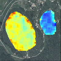
In order to investigate bio-physical parameters associated with water quality, a model based on calibrated and atmospherically corrected Remotely Sensed data has been implemented. Secchi Disk depth and chlorophyll concentration parameters were estimated in a system of very small lakes at Monticchio (Italy) using Landsat TM data. The model was developed through the use of stepwise multiple regression and gave high coefficients of determination (R2 = 0.82 for Secchi Disk and R2 = 0.72 for chlorophyll). Values for water transparency were strongly correlated with chlorophyll a concentration: a linear relationship between the two parameters showed a high coefficient of determination (R2 = 0.93). The case study shows that the application of this approach on lakes with a small surface area, such as the Monticchio lakes in Southern Italy, is effective and the developed model well describes the water quality parameters.

  Keywords


Water quality, Landsat, chlorophyll, Secchi Disk transparency, Remote Sensing, Monticchio Lakes

Authors’ address

(1)
G Mancino
A Nolè
M Amato
A Ferrara
Department of Crop Science, Forest and Environment, University of Basilicata, Potenza (Italy)
(2)
V Urbano
International PhD in “Crop system, Forest and Environmental Sciences”, University of Basilicata, Potenza (Italy)

Corresponding author

Citation

Mancino G, Nolè A, Urbano V, Amato M, Ferrara A (2009). Assessing water quality by remote sensing in small lakes: the case study of Monticchio lakes in southern Italy. iForest 2: 154-161. - doi: 10.3832/ifor0507-002

Academic Editor

Marco Borghetti

Paper history

Received: Apr 29, 2009
Accepted: May 23, 2009

First online: Jul 30, 2009
Publication Date: Jul 30, 2009
Publication Time: 2.27 months

Breakdown by View Type

(Waiting for server response...)

Article Usage

Total Article Views: 52470
(from publication date up to now)

Breakdown by View Type
HTML Page Views: 43431
Abstract Page Views: 3000
PDF Downloads: 5062
Citation/Reference Downloads: 81
XML Downloads: 896

Web Metrics
Days since publication: 5346
Overall contacts: 52470
Avg. contacts per week: 68.70

Article Citations

Article citations are based on data periodically collected from the Clarivate Web of Science web site
(last update: Feb 2023)

Total number of cites (since 2009): 34
Average cites per year: 2.27


Publication Metrics

by Dimensions ©

Articles citing this article

List of the papers citing this article based on CrossRef Cited-by.

 
(1)
Arenz RF, Lewis WM, Saunders JF (1996)
Determination of chlorophyll and dissolved organic carbon from reflectance data for Colorado reservoirs. International Journal of Remote Sensing 17: 1547-1566.
CrossRef | Gscholar
(2)
Baban SMJ (1993)
Detecting water quality parameters in the Norfolk Broads, U.K., using Landsat imagery. International Journal of Remote Sensing 14: 1247-1267.
CrossRef | Gscholar
(3)
Brezonik P, Menken KD, Bauer M (2005)
Landsat-based remote sensing of lake water quality characteristics, including chlorophyll and coloured dissolved organic matter (CDOM). Lake and Reservoir Management 4: 373-382.
CrossRef | Gscholar
(4)
Brivio AP, Lechi G, Zilioli E (2006)
Principi e metodi di telerilevamento. Città Studi Edizioni, Novara, Italy.
Gscholar
(5)
Brivio PA, Giardino C, Zilioli E (2001a)
Determination of chlorophyll concentration changes in Lake Garda using an image-based radiative transfer code for Landsat TM images. International Journal of Remote Sensing 22: 487-502.
CrossRef | Gscholar
(6)
Brivio PA, Giardino C, Zilioli E (2001b)
Validation of satellite data for quality assurance in lake monitoring application. The Science of the Total Environment 268: 19-29.
CrossRef | Gscholar
(7)
Bukata RP, Burton JH, Jerome JH (1983)
Use of chromaticity in remote measurements of water quality. Remote Sensing of Environment 13: 161-177.
CrossRef | Gscholar
(8)
Bukata RP, Jerome JH, Kondratiev KY, Pozdnyakov DV (1995)
Optical properties and remote sensing of inland coastal waters. CRC Press, Boca Raton, FL, USA.
Gscholar
(9)
Candiani G, Floricioiu D, Giardino C, Rott H (2005)
Monitoring water quality of the perialpine Italian Lake Garda trough multi-temporal MERIS data. Meris-(A) ATSR Workshop, Frascati (Italy) 26-30 September 2005. ESA, CD-ROM, ISBN 92-9092-908-1.
Gscholar
(10)
Caselles V, Lopez Garcia MJ (1989)
An alternative approach to estimate atmospheric correction in multitemporal studies. International Journal of Remote Sensing 10: 1127-1134.
CrossRef | Gscholar
(11)
Chavez PS (1988)
An improved dark object subtraction technique for atmospheric scattering correction of multispectral data. Remote Sensing of Environment 24: 459-479.
CrossRef | Gscholar
(12)
Chavez PS (1996)
Image-based atmospheric corrections - revisited and improved. Photogrammetric. Engineering and Remote Sensing 62: 1025-1036.
Gscholar
(13)
Cox RM, Forsythe RD, Vaughan GE, Olmsted LL (1998)
Assessing water quality in the Catawba River reservoirs using Landsat thematic mapper satellite data. Lake and Reservoir Management 14: 405-416.
CrossRef | Gscholar
(14)
Dekker AG, Peters SWM (1993)
The use of the Thematic Mapper for the analysis of eutrophic lakes: a case study in the Netherlands. International Journal of Remote Sensing 14: 799-821.
CrossRef | Gscholar
(15)
Dumontet S, Scopa A, Pasquale V, Franzese PP, Melchiorre R, Pariti L, Attolico A, Allegretti G (2001)
Studio delle caratteristiche morfometriche, limnologiche e chimico/microbiologiche dei Laghi di Monticchio. Assessorato Assetto e Programmazione del Territorio-Ambiente, Provincia di Potenza, Potenza, Italy.
Gscholar
(16)
Forster BC, Xingwei S, Baide X (1993)
Remote sensing of sea water quality parameters using Landsat TM. International Journal of Remote Sensing 14: 2759-2771.
CrossRef | Gscholar
(17)
Fraser RS (1998)
Multispectral remote sensing of turbidity among Nebraska sand hills lakes. International Journal of Remote Sensing 19: 3011-3016.
CrossRef | Gscholar
(18)
Fraser RS, Ferrare RA, Kaufman YJ, Markham BL (1992)
Algorithm for atmospheric corrections of aircraft and satellite images. International Journal of Remote Sensing 13: 541-557.
CrossRef | Gscholar
(19)
George DG (1997)
The airborne remote sensing of phytoplankton chlorophyll in the lake and tarns of the English Lake District. International Journal of Remote Sensing 18: 1961-1975.
CrossRef | Gscholar
(20)
Giardino C, Pepe M, Brivio PA, Ghezzi P, Zilioli E (2001)
Detecting chlorophyll, Secchi disk depth and surface temperature in a sub-alpine lake using Landsat imagery. The Science of the Total Environment 268: 19-29.
CrossRef | Gscholar
(21)
Giardino C (2006)
Telerilevamento per la qualità delle acque interne. In: “Telerilevamento Applicato”. Mako Edizioni, Quartu S.E., Italy, pp. 307-320.
Gscholar
(22)
Giardino C, Candiani G, Zilioli E (2005)
Detecting chlorophyll-a in Lake Garda (Italy) using TOA MERIS radiances. Photogrammetric Engineering and Remote Sensing 71: 1045-1052.
Online | Gscholar
(23)
Gitelson AA, Jacobi YZ, Schalles JF, Rundquist DC, Han L, Stark R, Etzion D (2000)
Remote estimation of phytoplankton density in productive waters. Archives of Hydrobiology and Advanced Limnology 55: 121-136.
Gscholar
(24)
Gordon HR (1987)
Calibration requirements and methodology of remote sensors viewing the oceans in the visible. Remote Sensing and Environment 22: 103-126.
CrossRef | Gscholar
(25)
Green S (2003)
The effect of chlorophyll concentration on airborne hyperspectral reflectance.
Online | Gscholar
(26)
Jaquet JM, Zand B (1989)
Colour analysis of inland water using Landsat TM data. In: “Monitoring the earth’s environment”. Publication ESA, SP-1102, pp. 57-67.
Gscholar
(27)
Kaufman YJ, Sendra C (1988)
Algorithm for automatic correction to visible and near-infrared satellite imagery. International Journal of Remote Sensing 9: 1357-1381.
CrossRef | Gscholar
(28)
Kaufman YJ (1989)
The atmospheric effect on remote sensing and its correction. In: “Theory and application of optical remote sensing”. John Wiley and Sons, New York, USA, pp. 336-428.
Gscholar
(29)
Kloiber SM, Brezonik PL, Bauer ME (2002b)
Application of Landsat imagery to regional-scale assessments of lake clarity. Water Research 36: 4330-4340.
CrossRef | Gscholar
(30)
Kloiber SM, Brezonik PL, Olmanson LG, Bauer ME (2002a)
A procedure for regional lake water clarity assessment using Landsat multispectral data. Remote Sensing of Environment 82: 38-47.
CrossRef | Gscholar
(31)
Lathrop RG (1992)
Landsat Thematic Mapper monitoring of turbid inland water quality. Photogrammetric Engineering and Remote Sensing 58: 465-470.
Gscholar
(32)
Lathrop RG, Lillesand TM (1986)
Use of Thematic Mapper data to assess water quality in Green Bay and Central Lake Michigan. Photogrammetric Engineering and Remote Sensing 52: 671-680.
Online | Gscholar
(33)
Lavery P, Pattiaratchi C, Wyllie A, Hick P (1993)
Water quality monitoring in estuarine waters using the Landsat Thematic Mapper. Remote Sensing of Environment 3: 268-280.
CrossRef | Gscholar
(34)
Leoni B, Garibaldi L (2009)
Population dynamics of <i>Chaoborus flavicans</i> and <i>Daphnia</i> spp.: effects on a zooplankton community in a volcanic eutrophic lake with naturally high metal concentrations (L. Monticchio Grande, southern Italy). Journal of Limnology 68 (1): 37-45.
Online | Gscholar
(35)
Li R, Li J (2004)
Satellite remote sensing technology for lake water clarity monitoring: an overview. Environmental Informatics Archives 2: 893-901.
Gscholar
(36)
Lillesand TM, Kiefer RW, Chipman JW (2004)
Remote sensing and Image Interpretation. John Wiley and Sons, New York, USA.
Gscholar
(37)
Lillesand TM, Johnson WL, Deuell R L, Lindstrom OM, Meisner DE (1983)
Use of Llndsat data to predict the trophic state of Minnesota lakes. Photogrammetric Engineering and Remote Sensing 49: 219-229.
Gscholar
(38)
Lindell T, Karlsson B, Rosengren M, Alfoldi TT (1986)
A further development of the chromaticity technique for satellite mapping of suspended sediment load. Photogrammetric Engineering and Remote Sensing 52: 1521-1530.
Online | Gscholar
(39)
Maul GA (1985)
Introduction to satellite oceanography. Martinus Nijhoff Publishers, Dordrecht/Boston/Lancaster.
Gscholar
(40)
Mayo M, Gitelson A, Yacobi YZ, Ben-Avraham Z (1995)
Chlorophyll distribution in Lake Kinneret determined from Landsat Thematic Mapper data. International Journal of Remote Sensing 16: 175-182.
CrossRef | Gscholar
(41)
Ministero dell’Ambiente e della Tutela del Territorio e del Mare (2007)
Laghi vulcanici: il fuoco, l’acqua e la vita. Quaderni Habitat 17, Roma, Italy, pp. 53.
Gscholar
(42)
Moran MS, Jackson JD, Slater PN, Teillet PM (1992)
Evaluation of simplified procedures for retrieval of land surface reflectance factors from satellite sensor output. Remote Sensing of Environment 41: 169-184.
CrossRef | Gscholar
(43)
Nash JE, Sutcliffe JV (1970)
River flow forecasting through conceptual models, Part I - A discussion of principles. Journal of Hydrology 10: 282:290.
CrossRef | Gscholar
(44)
Richter R (1990)
A fast atmospheric correction algorithm applied to Landsat TM images. International Journal of Remote Sensing 11: 159-166.
CrossRef | Gscholar
(45)
Ritchie R, Cooper CM, Schiebe FR (1990)
The relationship of MMS and TM digital data with suspended sediments, chlorophyll and temperature in Moon lake, Mississippi. Remote Sensing of Environment 33: 137-148.
CrossRef | Gscholar
(46)
Sass GZ, Creed IF, Bayley S.E, Devito KJ (2007)
Understanding variation in trophic status of lake on Boreal Plain: a 20 year retrospective using Landsat TM imagery. Remote Sensing of Environment 109: 127-141.
CrossRef | Gscholar
(47)
Schiebe FR, Harrington JA, Ritchie JC (1992)
Remote sensing of suspended sediments: the Lake Chicot, Arkansas project. International Journal of Remote Sensing 13: 1487-1509.
CrossRef | Gscholar
(48)
Schneider K, Mauser W (1996)
Processing and accuracy of Landsat thematic mapper for lake surface temperature measurement. International Journal of Remote Sensing 11: 2027-2041.
CrossRef | Gscholar
(49)
Strombeck N, Candiani G, Giardino C, Zilioli E (2003)
Water quality monitoring of Lake Garda using multi-temporal MERIS data. Meris-(A) ATSR Workshop, Frascati (Italy) 10-13 November 2003. ESA, CD-ROM, ISBN 92-9092-860-3.
Gscholar
(50)
Teillet PM, Horler DNH, O’Neill NT (1997)
Calibration, validation and quality assurance in remote sensing: a new paradigm. Canadian Journal of Remote Sensing 4: 401-414.
Online | Gscholar
(51)
Teillet PM, Fedoseievs G (1995)
On the dark target approach to atmospheric correction of remotely sensed data. Canadian Journal of Remote Sensing 21: 374-387.
Gscholar
(52)
Vermote EF, Tanré D, Denzé JL, Herman M, Morcrette JJ (1997)
Second simulation of the satellite signal in the solar spectrum, 6S: an overview. IEEE Transaction on Geoscience and Remote Sensing 35: 675-686.
CrossRef | Gscholar
(53)
Vincent RK, Qin X, McKay ML, Miner J, Czajkowski K, Savino J, Bridgeman T (2004)
Phycocyanin detection from LANDSAT TM data for mapping cyanobacterial blooms in Lake Erie. Remote Sensing of Environment 89: 381-392.
CrossRef | Gscholar
(54)
Wang Y, Xia H, Fu J, Sheng G (2004)
Water quality change in reservoirs of Shenzhen: detection using Landsat/TM data. The Science of the Total Environment 328: 195-206.
CrossRef | Gscholar
(55)
Willmott CJ (1981)
On the validation of model. Phys. Geogr. 2: 184-194.
Gscholar
(56)
Zilioli E, Brivio PA (1997)
The satellite derived optical information for the comparative assessment of lacustrine water quality. The Science of the Total Environment 196: 229-245.
CrossRef | Gscholar
(57)
Zilioli E, Brivio PA, Gomarasca MA (1993)
Spectral and chromaticity-based analysis of Landsat data for the chlorophyll assessment in the lakes Maggiore, Como and Garda. Proceeding of the 5<sup>th</sup> International Conference on the “Conservation and Management of Lakes”. Stresa (Italy) 17-21 May 1993, pp. 229-232.
Gscholar
(58)
Zilioli E, Brivio PA, Gomarasca MA (1994)
A correlation between optical properties from satellite data and some indicators of eutrophication in Lake Garda (Italy). The Science of the Total Environment 158: 127-133.
CrossRef | Gscholar
 

This website uses cookies to ensure you get the best experience on our website. More info