Historical and contemporary forest ecosystem changes in the Beskid Mountains (southern Poland) between 1848 and 2014
iForest - Biogeosciences and Forestry, Volume 10, Issue 6, Pages 939-947 (2017)
doi: https://doi.org/10.3832/ifor2418-010
Published: Dec 19, 2017 - Copyright © 2017 SISEF
Research Articles
Abstract
Landscape changes in the Carpathians are related to centuries of human activity, which can be regarded as the key component of global change. Changes in mountainous regions are mainly caused by agriculture, urbanization, forest cutting for production and land abandonment. This paper aimed to assess the impact of natural and historical-cultural factors on forest ecosystem transformations occurred in the period 1848-2014 in two small areas (about 45 km2) on the Beskid Mountains (southern Poland). The comparison of historical and current maps, along with the application of GIS and field verification, allowed a full interpretation of changes in land use in the studied areas. A decrease of 58.0% in non-forest areas was observed in the considered period, while the forested area grew systematically by 28.3% and the forest-field boundary lowered in altitude. Current forest ecosystems are distributed as a mosaic and mainly consist of Dentario glandulosae-Fagetum, Luzulo nemorosae-Fagetum, Abieti-Piceetum montanum, with logged sites taking up large areas. Forest ecosystems include valuable semi-natural meadows such as Gladiolo-Agrostietum, Hieracio-Nardetum, Arrhenatheretum medioeuropaeum, Cirsietum rivularis or Juncetum effusi, whose extension is reducing and fragmentation increasing due to the recolonization of forest tree species after abandonment. We concluded that trends in land use in the Carpathians were mainly determined by non-environmental factors related to the development of farming-pasturing and forest management. The applied approach could be extended to other regions in the Carpathians which were subject to analogous historical-cultural influences. Moreover, our results allow for a comparison with other regions which are subject to similar impacts of natural processes, but to different impact of historical and cultural processes.
Keywords
Landscape Research, Forest Transformation, Land Use Changes, Historical Maps, Poland, Beskid Mountains, Carpathians
Introduction
Landscape is subject to increasing anthropogenic transformation in land use or land cover, which can be interpreted both locally and globally ([2], [39]). Analysis and evaluation of the rate of these changes are feasible when reliable cartographic resources recording land use and types of land cover through time are available. Beside the educational value, the interpretation of these resources is also important from the economic point of view, as it makes possible the optimization of contemporary economic processes ([35]). Analysis of changes in land use over time also enables to assess the impact of natural factors - both positive (fertile soils, small height differences, mild climate, etc.) and negative (flooding, mass-movements, volcanic eruptions, pest gradation, natural fires, etc.) on the landscape.
Landscape diversification has increased in the past decades, often resulting in disturbances to the functioning of ecosystems ([13], [16]). Typological diversification of landscapes has been occurring over time because of human economic activities through centuries, determining the development of specific anthropogenic ecological systems within various landscape zones ([8], [50], [30], [29], [7], [33]). Such activities include urbanization, intensification of agriculture, forest cutting for production and/or land abandonment ([35]), whose impact varies regionally depending on local socio-economic and natural conditions ([34]).
The main types of landscape change over Europe and their driving factors have been widely discussed in a recent review ([35]). Similar analyses have been carried out in the Carparthians ([14], [29]), and in areas adjacent to the Beskid Mountains in Poland ([4]), mainly focused on changes in forest areas and the farming use of land. Changes in the forest cover over the past 180 years have been examined in western and northern Carpathians ([19], [20], [21]).
Carpathian mountain range covers more than 190.000 km2 throughout eastern Europe, extending for 1300 km in length and 120-350 km in width, and includes a unique combination of ecosystems. The Carpathians run through as many as 7 countries: Slovakia (about 71 % of its area), Romania (ca. 47%), Czechia (ca. 8%), Hungary (ca. 8%), Poland (over 6%), Ukraine, Austria and Serbia. As a consequence, different models of land management, determined both historically and culturally, have appeared and still exist in different parts of the Carpathians ([29]), resulting in regional differences in changes in ecosystems and landscapes.
Changes in specific landscape elements (forests, abandoned land, meadows, hydrographic networks, cultural elements) have been analysed throughout the Carpathian range with different degrees of detail ([18], [32], [20]). However, most studies were large-scales investigations based on either cartographic resources or satellite- and aerial imagery aimed at quantifying changes in forest cover ([21], [29]). Contrastingly, few studies have focused on changes in species composition of forests in the Silesian and Zywiec Beskid Mountains, which are part of the Polish Carpathians.
The aim of this paper was to determine the impact of natural and historical-cultural factors on forest ecosystem transformations in the Silesian and Zywiec Beskid Mountains over the period 1848-2014. An accurate assessment of landscape changes was carried out in two small mountainous areas (< 100 km2) which had been exploited by man for centuries. A detailed verification in the field of the results obtained from cartographic analyses allowed to recognize the transformation of fir-beech phytocenoses and the succession in managed spruce forests in the light of natural and anthropogenic factors.
Materials and methods
Description of the study area
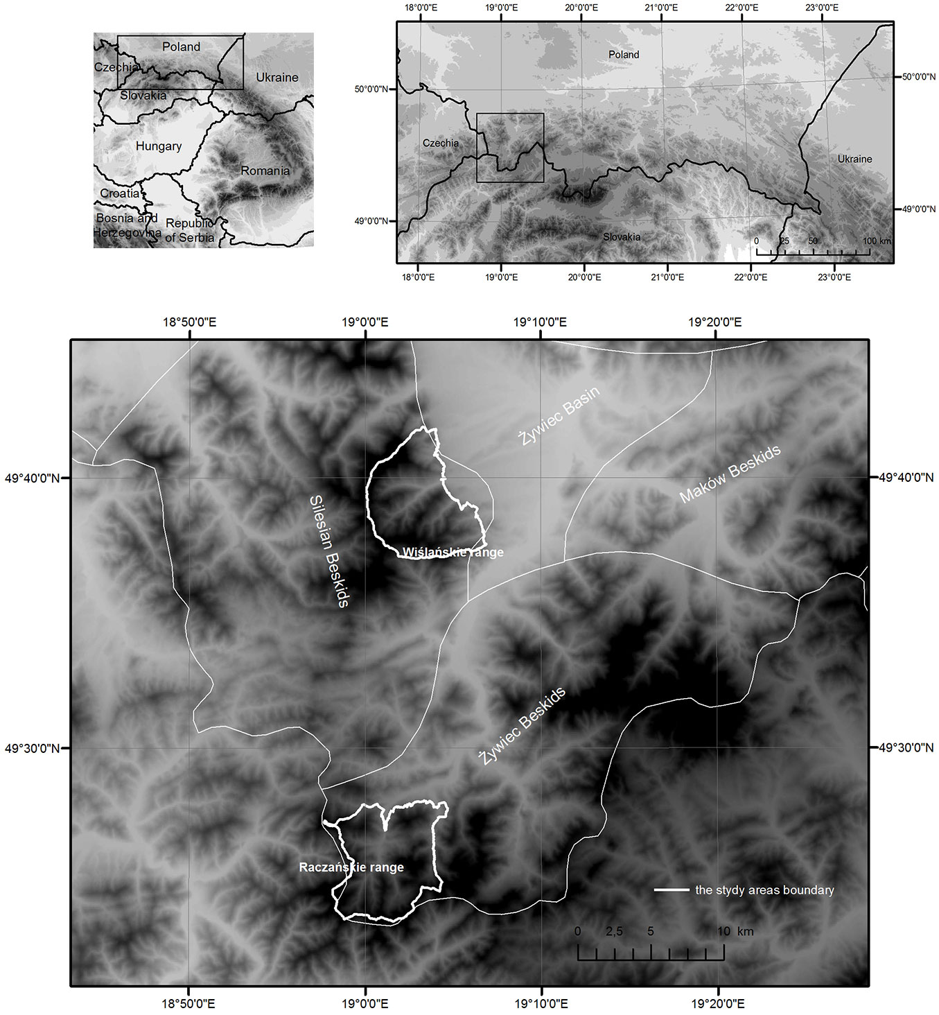
The Beskid range (Western Carpathians) stretches for about 600 km from the Bečva River in the west to the Cheremosh River in the east, and reaches a width of about 50-70 km. We selected two research areas (the Barania Góra Range and Racza Range, each covering about 45 km2) situated in the Western Beskids (49° 32′ 45″ N, 18° 26′ 51″ E - Fig. 1), both characterized by medium- and low mountain relief with steep slopes (mean elevation > 800 m a.s.l.). The basement is made from formations of the Godula Nappe and the Magura Nappe of the Carpathian Flysch Belt. The areas span over three vertical climatic zones, namely, moderate warm (with mean temperature > 6 °C), moderate cool (4-6 °C) and cool (< 4 °C). Precipitation on the highest ridges (Skrzyczne or Wielka Racza) reaches 1300 mm year-1.
Fig. 1 - Location of the two surveyed area (Barania Góra Range and Racza Range) in the Polish Carpathians.
The natural conditions of the area are suitable to forests and meadows/grasslands, whereas current land use reflects the socio-political and economic conditions in the late 19th century, when the Beskid region was heavily populated and large areas were deforested for agricultural use, despite unfavourable topographic-, soil- and climatic conditions ([42]). This has generated the current traditional landscape typical of the Beskid region, with buildings situated in the valley bottom on lower river terraces with accompanying woods and shrubs, and cropfields perpendicular to the valley bottom divided by clearly marked baulks, which reach up to the edge of the forest on mountain ridges. Numerous clearings with farmsteads are located in flat areas of the forest, and mountain ridges includes pasture grounds which recently decreased in area due to the abandonment of breeding farm management.
Cartographic analysis
For the analysis of changes in landscape over time, only maps based on direct field mapping were selected in this study. We decided to select map series with similar scales and objectives; however, we encountered serious difficulties to match such criteria. Therefore, only six of the seven maps acquired were used in this study, as reported in Tab. 1.
Tab. 1 - Cartographic materials used for the analyses.
| Map type | Map sheets | Year | Scale |
|---|---|---|---|
| Austrian cadastral maps | Lipowa, Ostre, Radziechowy, Rycerka Górna | 1848 | 1:2.880 |
| Spezialkarte der Österreichisch-Ungarischen Monarchie | Saysbush | 1879 | 1:75.000 |
| Ujsoly-Stara Bistrica | 1885 | 1:75.000 | |
| WIG military map | Zywiec, Ujsoly | 1933 | 1:100.000 |
| Military topographic map | Szczyrk, Wegierska Górka | 1960 | 1:25.000 |
| Nova Bistrica, Oscadnica, Rycerka Dolna, Zborov nad Bistricou | 1975 | ||
| Topographic map of Poland | Barania Góra, Lipowa, Mlada Hora, Przegibek, Szczyrk Malinów, Tatarki, Wegierska Górka, Wielka Racza | 1979 | 1:10.000 |
| Orthophotomap | - | 2009 | field pixel size of 0.25 m |
All the historical maps were georeferenced in two steps, which consisted in: (i) calculating the transformation matrix; (ii) carrying out proper geometric transformation and interpolation resampling of a distorted image to a new raster of regular size (i.e., the so-called “rubbersheeting”). Such two-step process allowed a higher georeferencing accuracy, which ensures the quality of results obtained and increases the confidence in the conclusions. In each case, georeferencing was specifically adjusted to the quality and type of data, so as to achieve the best possible results for each series.
Austrian cadastral maps were overlaid onto a grid with a size corresponding to the map frame size using affine transformation and the coordinates of the frame corners. Rectification was then carried out and its precision verified by estimating the root-mean-square error (RMSE), which was < 4.91 m for each map sheet.
The Spezialkarte der Österreichisch-Ungarischen Monarchie was georeferenced only by means of control points of the reference layer using the affine transformation. This kind of georeferencing of a single map sheet gives better results than that based on fitting the corners in the millimeter-mesh grid ([1]).
The military maps were georeferenced by overlaying the corner points of the raster image onto the grid with a size corresponding to the map frame size using affine transformation. Rectification was then carried out and the image was adjusted to the reference layer using control points.
For all maps, historical local reference system was transformed into the contemporary global system. This step involved the application of a simplified Helmert transformation with three parameters (dx, dy, dz) of the shift in the coordinate system origin using the inverse Molodensky formulas ([42]).
The processed cartographic materials underwent screen digitization using the snapping method. Errors are usually generated during this operation, e.g., duplicating arcs, floating- or short lines, overlapping lines, overshoots and undershoots, unclosed- and weird polygons ([24]). A topology construction tool was used to detect and eliminate these errors.
Screen digitization was combined with the creation of a database of land-use and land-cover forms. By aggregating the data included in each series of maps, land-cover maps were developed where forest and non-forest areas were clearly distinguishable. In both cases, the road network and the hydrographic network were attached to the adjoining polygons, as the boundaries ran along roads and watercourses.
As a result of the procedures described above, vector maps were created which allowed spatial analyses to be carried out. The V_LATE add-on of the package ArcGIS® ver. 10.2.2 was used, which allowed to calculate landscape metrics describing land cover and the forest-field boundary in each time section. Indicators of changes in forest and non-forest cover in each time section were calculated by the following parameters:
- Changes in Forest Area (
CF=FAt+1-FAt); - Changes in Non-forest Area (
CN=NAt+1-NAt); - Changes in Forest Area in relation to Total Area (
CFA= 100·CF/TA); - Changes in Non-forest Area in relation to Total Area (
CNA= 100·CN/TA); - Changes in Forest Area in relation to Forest Area in 1848 (
CFT1848 =CA-FA1848); - Changes in Non-forest Area in relation to Non-forest Area in 1848 (
CNT1848 =CA-NA1848); - Percentage changes in Forest Area between time section t+1 and t [
CPF= 100 · (FAt+1-FAt)/FAt]; - Percentage changes in Non-forest Area between time section t+1 and t [
CPN= 100 · (NAt+1-NAt)/NAt].
Analysis of vegetation changes
The analysis of changes in forest and non-forest areas was conducted for the years 1848-2014 on the basis of the available cartographic resources (Tab. 1). The maps differed with regard to land-cover forms (including vegetation types). Only some maps contained information on forest types, which were classified as deciduous or coniferous. Consequently, it was not possible to compare vegetation changes (in terms of plant communities and associations) for all time intervals. Therefore, vegetation changes over time were inferred by comparing the current vegetation map based on field mapping performed with an itinerary method ([41]) and the map of potential natural vegetation of Poland ([26]). The latter map was used as reference for determining changes in the forest associations in the analysed areas. It was the only applicable method due to lack of information on past forest types in the study area.
Results
Changes in forest and non-forest cover in years 1848-2014
In both study areas, the forest cover grew systematically at the expense of non-forest areas in the period 1848-2014 due to the abandonment of agriculture (Tab. 2, Tab. 3, Fig. 2, Fig. 3). The increase in forest cover in the Racza Range was higher than that observed in the Barania Góra Range (16.7 % vs. 11.8 %, respectively). The greatest changes in the Barania Góra Range, affecting 6.8 % of the examined region, took place between 1933 and 1960, whereas in the Racza Range forest cover changed continuously since 1933 and involve 13.9 % of the investigated area.
Tab. 2 - Changes in land cover between 1848 and 2014. (FA): Forest Area; (FPL): Forest Percentage of Landscape; (NFP): Number of Forest Patches; (MFA): Maximal Forest Patches Area; (NA): Non-forest Area; (NPL): Non-forest Percentage of Landscape; (NNP): Number of Non-Forest Patches; (MNA): Maximal Non-Forest Patches Area.
| Range | Time section |
FA(ha) |
FPL(%) |
NFP
|
MFA(ha) |
NA(%) |
NPL(%) |
NNP
|
MNA(ha) |
|---|---|---|---|---|---|---|---|---|---|
| Barania Góra | 1848 | 3699.1 | 82.1 | 9 | 3693.9 | 807.2 | 17.9 | 142 | 165.7 |
| 1879 | 3707.5 | 82.3 | 2 | 3706.5 | 798.8 | 17.7 | 95 | 174.0 | |
| 1933 | 3840.8 | 85.2 | 1 | 3848.1 | 665.5 | 14.8 | 83 | 84.6 | |
| 1960 | 4145.3 | 92.0 | 12 | 4116.3 | 361.0 | 8.0 | 100 | 58.6 | |
| 1979 | 4213.9 | 93.5 | 14 | 4217.8 | 292.4 | 6.5 | 151 | 38.0 | |
| 2014 | 4230.2 | 93.9 | 18 | 4226.0 | 276.1 | 6.1 | 106 | 25.4 | |
| Racza | 1848 | 3137.8 | 68.8 | 17 | 2994.7 | 1423.0 | 31.2 | 89 | 462.3 |
| 1885 | 3164.0 | 69.4 | 14 | 2819.8 | 1396.8 | 30.6 | 49 | 435.8 | |
| 1933 | 3262.5 | 71.5 | 15 | 2627.8 | 1298.3 | 28.5 | 33 | 454.9 | |
| 1975 | 3592.2 | 78.8 | 48 | 3530.0 | 968.6 | 21.2 | 89 | 394.5 | |
| 1979 | 3619.4 | 79.4 | 79 | 3292.1 | 941.4 | 20.6 | 140 | 353.7 | |
| 2014 | 3899.7 | 85.5 | 30 | 3853.6 | 661.1 | 14.5 | 66 | 115.5 |
Tab. 3 - Dynamics of land cover changes between 1848 and 2014. (CF): Changes of Forest Area; (CFA): Changes of Forest Area relative to Total Area; (CFT): Changes of Forest Area relative to Forest Area in 1848; (CPF): Percentage changes of Forest Area between time section t+1 and t; (CN): Changes of Non-forest Area; (CAN): Changes of Non-forest Area in relations to Total Area; (CNT): Changes of Non-forest Area in relations to Non-forest Area in 1848; (CPN): Percentage changes of Non-forest Area between time section t+1 and t.
| Range | Time interval |
CF(ha) |
CFA(%) |
CFT(ha) |
CPF(ha) |
CN(ha) |
CNA(%) |
CNT(ha) |
CPN(ha) |
|---|---|---|---|---|---|---|---|---|---|
| Barania Góra | 1848-1879 | 8.4 | 0.2 | 8.4 | 0.2 | -8.4 | -0.2 | -8.4 | -1.0 |
| 1879-1933 | 133.6 | 3.0 | 142.0 | 3.6 | -133.6 | -3.0 | -142.0 | -16.7 | |
| 1933-1960 | 304.5 | 6.8 | 446.2 | 7.9 | -304.5 | -6.8 | -446.2 | -45.8 | |
| 1960-1979 | 68.6 | 1.5 | 514.8 | 1.7 | -68.6 | -1.5 | -514.8 | -19.0 | |
| 1979-2014 | 16.3 | 0.4 | 531.1 | 0.4 | -16.3 | -0.4 | -63.8 | -5.6 | |
| Racza | 1848-1885 | 26.2 | 0.6 | 26.2 | 0.8 | -26.2 | -0.6 | -26.2 | -1.8 |
| 1885-1933 | 98.5 | 2.2 | 124.7 | 3.1 | -98.5 | -2.2 | -124.7 | -7.1 | |
| 1933-1975 | 329.7 | 7.2 | 454.4 | 10.1 | -329.7 | -7.2 | -454.4 | -25.4 | |
| 1975-1979 | 27.2 | 0.6 | 481.6 | 0.8 | -27.2 | -0.6 | -481.6 | -2.8 | |
| 1979-2014 | 280.3 | 6.1 | 761.9 | 7.7 | -280.3 | -6.1 | -761.9 | -29.83 |
Fig. 2 - Changes in forest land cover in the Barania Góra Range between 1848 and 2014. (1): Forest areas (dark green); (2): non-forest areas (light green).
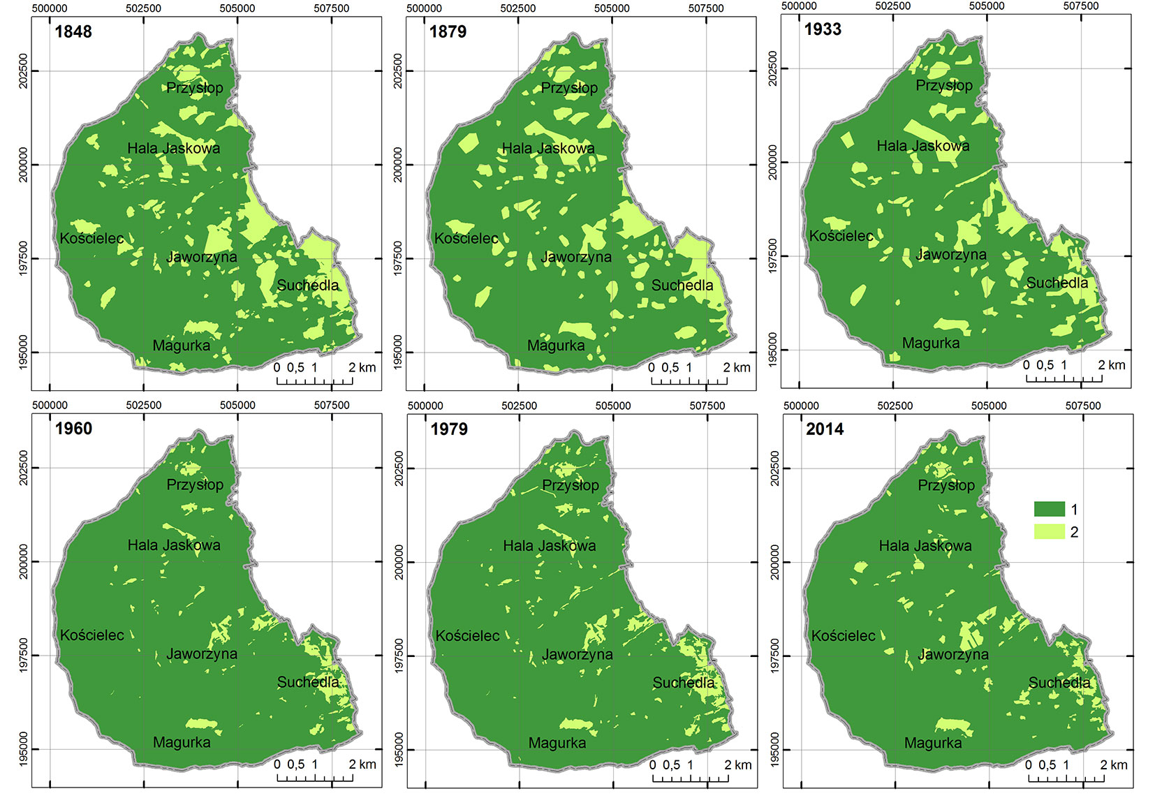
Fig. 3 - Changes in forest land cover in the Racza Range between 1848 and 2014. (1): Forest areas (dark green); (2): non-forest areas (light green).
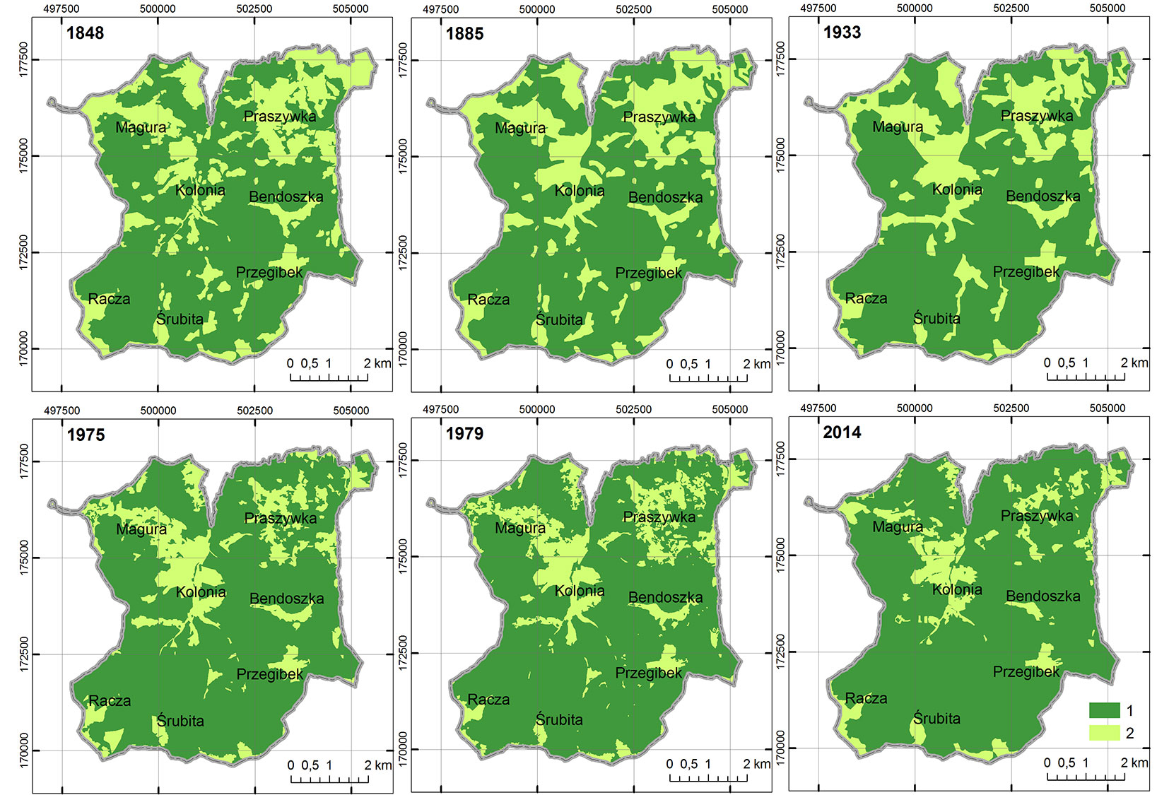
Throughout 1848-2014, the number of non-forest patches was higher than that of forest patches, with different trends through time in the two studied regions. In the Barania Góra Range, we observed an increase in the largest forest patches over the considered period, whereas in the Racza Range it decreased until 1933 and then started to increase.
Changes in the forest-field boundary
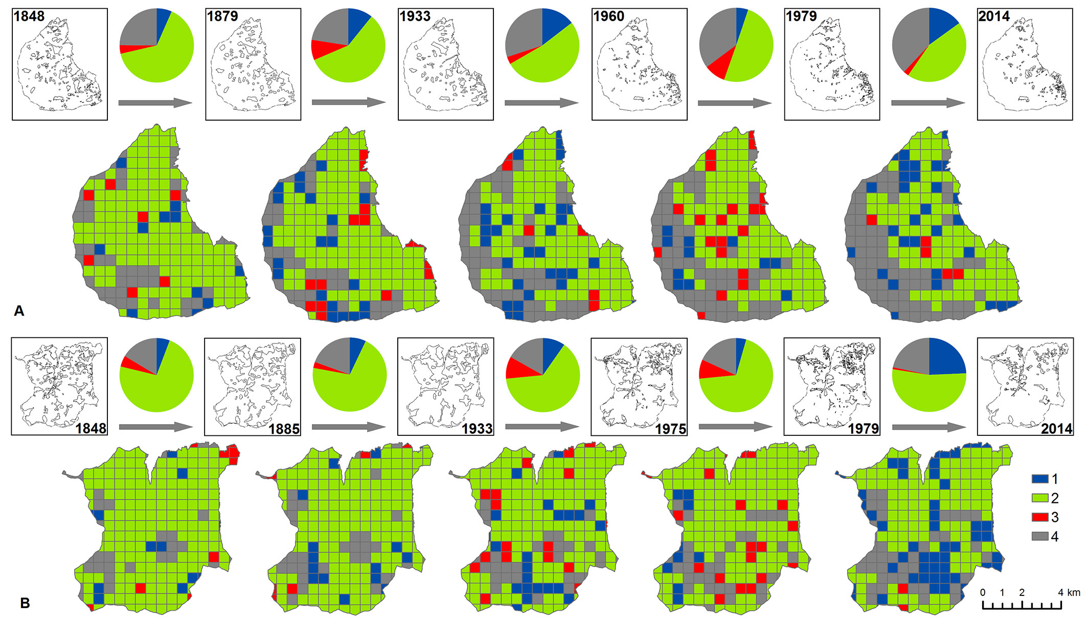
In both the Barania Góra Range and the Racza Range, the length of the forest-field boundary initially decreased (by 39.4 km and 45.4 km, respectively), and then increased (by 13.3 and 67.3 km) before decreasing again (by 15.4 and 68.2 km). The numbers of boundaries and patches reveal a similar tendency. In both study areas the forest-field boundary was observed to progressively decrease in elevation (Fig. 4). To illustrate the effect of the map scales on the results, data on the number of borders and their minimum lengths are given in Tab. 4. The main trends of changes in the length and numbers of forest boundaries and patches are shown in Tab. 5.
Fig. 4 - Dynamics of forest-field boundary occurrence in the Barania Góra Range (A) and Racza Range (B) between 1848 and 2014. The diagrams show the number of basic fields as follows: (1): vanished forest-field boundary (in blue); (2): continuing forest-field boundary (in green); (3): emerging forest-field boundary (in red); (4): no forest-field boundary (in grey).
Tab. 4 - Changes in the forest-field boundary between 1848 and 2014.
| Study area | Time section |
Total Edge (TE, km) |
Edge Density (ED, m ha-1) |
Number of Edge (NE) |
Minimal Edge (ME, m) |
|---|---|---|---|---|---|
| Barania Góra Range | 1848 | 123.4 | 27 | 151 | 33 |
| 1879 | 96.1 | 21 | 96 | 228 | |
| 1933 | 95.8 | 21 | 83 | 125 | |
| 1960 | 84.0 | 19 | 113 | 79 | |
| 1979 | 97.3 | 22 | 164 | 34 | |
| 2014 | 81.9 | 18 | 123 | 48 | |
| Racza Range | 1848 | 156.7 | 34 | 106 | 45 |
| 1885 | 120.5 | 26 | 62 | 188 | |
| 1933 | 111.3 | 24 | 47 | 280 | |
| 1975 | 151.3 | 33 | 134 | 81 | |
| 1979 | 178.6 | 39 | 222 | 33 | |
| 2014 | 110.4 | 24 | 96 | 62 |
Tab. 5 - Trend of changes in boundary length and number of boundary and patches between 1848 and 2014. (+): increase; (-): decrease.
| Time interval | Barania Góra Range | Racza Range | ||||
|---|---|---|---|---|---|---|
| Boundary length |
Boundary number |
Patch number |
Boundary length |
Boundary number |
Patch number |
|
| 1848-1879 | - | - | - | - | - | - |
| 1879-1933 | - | - | - | - | - | - |
| 1933-1960 | - | + | + | + | + | + |
| 1960-1979 | + | + | + | + | + | + |
| 1979-2014 | - | - | - | - | - | - |
Vegetation changes
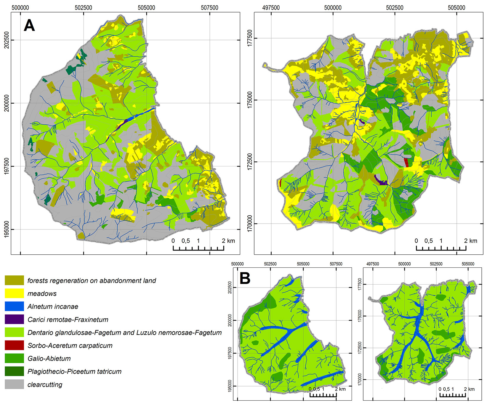
The study area is situated within the foothills and the lower forest zone (lower subalpine zone) which is the optimum (climax) for Fagus sylvatica and Abies alba, the main species characterizing beech and fir-beech forests. The plant communities typical of these layers are: Alnetum incanae, Carici remotae-Fraxinetum, Dentario glandulosae-Fagetum, Luzulo nemorosae-Fagetum, Sorbo-Aceretum carpaticum, Abieti-Piceetum montanum and Plagiothecio-Piceetum tatricum.
The comparison of potential natural vegetation with current vegetation distribution revealed large changes in both species composition and the distribution of forest associations in the two study area (Fig. 5).
The grey alder association Alnetum incanae can only be found at sites in alluvial river valleys on mountain alluvial soils. The main tree species is Alnus incana; other species are Fraxinus excelsior, Acer pseudoplatanus, Picea abies, Abies alba, Salix fragilis and Salix alba. Small areas in river valleys are occupied by ash carrs Carici remotae-Fraxinetum, where the tree layer is mainly represented by Fraxinus excelsior and Alnus glutinosa with the addition of Fagus sylvatica, Acer pseudoplatanus, Picea excelsa, Alnus incana, Quercus robur, Salix alba and Salix fragilis.
The most extended floral habitat in the Silesian and Zywiec Beskids is the fertile Carpathian beech wood Dentario glandulosae-Fagetum. The largest and best preserved parts of this association remained in the Racza Range. The dominant association Dentario glandulosae-Fagetum typicum is composed of Fagus sylvatica, Acer psudoplatanus, Fraxinus excelsior, Abies alba and Picea abies. Another frequently occurring association is acid beech wood Luzulo nemorosae-Fagetum, which is almost solely composed of Fagus sylvatica, with a small proportion of Abies alba, Acer pseudoplatanus, Fraxinus excelsior, Picea abies, Betula pendula and Quercus robur.
The Carpathian sycamore Sorbo-Aceretum carpaticum, composed of Sorbus aucuparia, Acer pseudoplatanus, and Fagus sylvatica with a proportion of Picea abies, occurs sporadically, with trees often low and twisted.
Near-top parts of slopes are mainly occupied by the low montane fir-spruce wood Abieti-Piceetum montanum. The tree layer is composed of Picea abies, Abies alba, Fagus sylvatica, Sorbus aucuparia; Acer pseudoplatanus and Betula pendula also occur sporadically.
The West-Carpathian spruce forest association Plagiothecio-Piceetum tatricum is not commonly found due to the altitude of the study area. Small fragments can be found in higher parts of the Barania Góra Range. The dominant species is Picea abies with a rare amount of Sorbus aucuparia.
Non-forest patches with dominant semi-natural associations often occur within the forests in the two study areas. These patches mainly include various types of meadows and pastures, characterized by the following plant communities: Gladiolo-Agrostietum, Hieracio-Nardetum, Arrhenatheretum medioeuropaeum, Cirsietum rivularis and Juncetum effusi. Some of the lower meadows transformed into permanent hamlets. Starting from mid-19th century, recolonization by forest tree species decreased the size of non-forest patches (Fig. 2, Fig. 3, Tab. 2, Tab. 3). Currently, large areas without forest cover are present in higher parts of the hills and on hilltops, due to planned forest management in the early 21st century (Fig. 5).
Discussion
Map types and interpretation of results
The maps used in this study differ both in terms of scale (from 1:2.880 of the Austrian cadastral maps to 1:100.000 of the WIG military maps), their use (military or administrative purposes) and map projection. Therefore, results based on these maps need careful interpretation and verification using other data sources. Furthermore, the results could be affected by errors occurring at each stage of the creation of a digital map; particularly, georeferencing greatly affects the quality of results. Furthermore, the information value of map data is lower compared to direct source data, having a lower precision and accuracy. Being aware of the limitations of maps is the basis for drawing correct conclusions ([38]).
The main results of this study, obtained by applying the most appropriate methods of analysis of cartographic historical data, can be summarized as follows:
- The dynamics of changes in land cover in two areas of the Beskid mountains were assessed by comparing the distribution and extension of different land cover types on maps from different time intervals. Although the results obtained should not be treated as absolute (see the above considerations), it was still possible to assess the trends related to changes in land cover in the study areas.
- The course of the forest-field boundary was analyzed with great care, as its length and density are particularly dependent on the map scale. The geometric simple choropleth method was used for this purpose. Applying a definite size of the basic field in relation to some generalization of the map contents allows excessive precision to be avoided. The size of the basic field was determined by the geometric method.
- The detection of changes in forest ecosystems based on cartographic materials was feasible only in terms of tracking changes in spatial distribution of forest/ non-forest areas. A detailed analysis of changes in forest ecosystems in terms of transformations of particular forest associations (their spatial distribution and composition in species) is only possible based on field research. The comparison of current distribution of particular forest associations with the potential vegetation has provided important hints for assessing the impact of cultural-historical factors on changes in forest ecosystems.
Changes in land use between 1848-2014
Forest landscapes in the Silesian- and Zywiec Beskids are located at higher elevations (forest belt) and include non-forest glades and pastures. On the other hand, agricultural landscapes are situated at lower elevations (foothill belt), and includes forest patches, like small enclaves next to water courses or on steeper slopes. Our results highlight that the forest belt increased in the period 1848-2014 at the expense of the foothill belt. As in other parts of the Carpathians, changes in the forest area were closely related to changes in the range of areas used for agricultural activities ([8], [29], [4]).
Our results on the length of the forest-field boundary should not be treated as actual absolute values. However, they can be useful to assess the importance of the various spatial processes involved in the transformation of the landscape ([10]). In general, we observed a decrease in length of the forest-field boundary through time, and a reduction in number of boundaries and patches. This could have been caused by the shrinkage of non-forest patches rather than their fragmentation. When fragmentation of patches becomes dominant over their shrinkage, the number and length of boundaries and the number of patches started to increase ([10]).
The trends in land use in the two studied areas were mainly determined by non-environmental factors. Land use in 1848 was the result of the so-called “land hunger”. Overpopulation and poor economic conditions forced to set arable lands at higher elevations and sloping hills, although most sites were unsuitable for crops. As a result, land use was far from sustainable in the mid-19th century and the pressure on the environment was high. At that time, the landscape was highly diversified, as occurring in other European countries ([2]).
Due to slightly different starting natural conditions, the land use structure was closer to the optimum in the Racza Range than in the Barania Góra Range, being the latter lesser managed than the former. This reflects the harsher geomorphological conformation of the Racza Range, which still represents a barrier for transports ([43]).
Starting from the late 19th century, intensified forest management and access limitations to forests contributed to a progressive reduction of the traditional meadow-pasture management. Furthermore, increased acquisition of land for residential building and crops caused a reduction in the area for pasture. Additionally, the outflow of people towards the growing industrial centers and high market competition for sheep products contributed to the abandonment of pasture management in the higher parts of the mountains ([12], [22]). As a consequence, clearings and pastures were overgrown with forest and their size decreased. Nevertheless, grazing continued in some clearings and pastures until the 1990s. The gradual disappearance of seasonal shepherding resulted in secondary succession of forest to take place onto unused pastures and clearings; some of these are now completely forested (Fig. 6a).
Fig. 6 - (a) Secondary succession of forest onto unused pastures; (b) Sheep grazing as a nature conservation measure; (c) Clearcutting as a result of forest degradation.
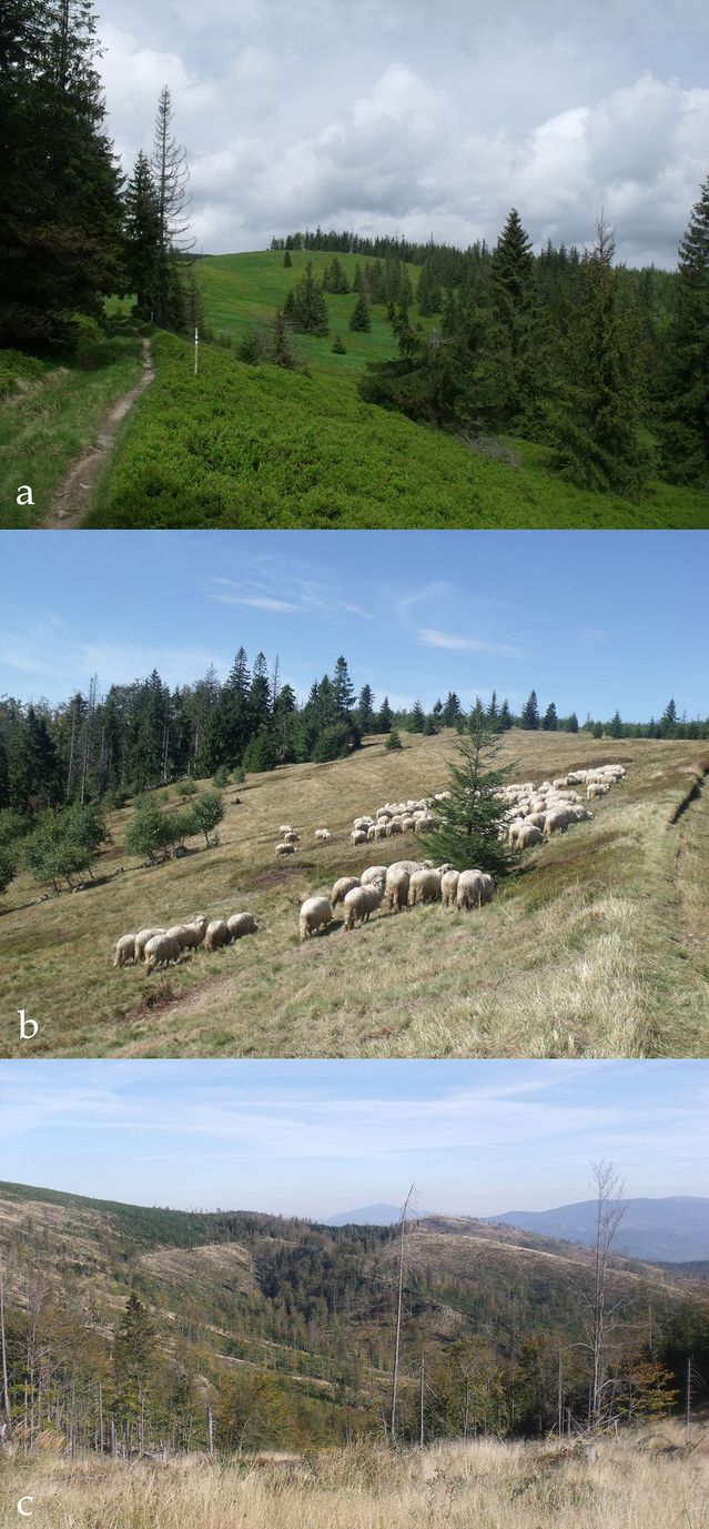
The decrease in the non-forest area is still ongoing on the entire range of the Polish Carpathians as a result of political changes and socio-economic transformation, e.g., the ending of subsidies for mountain farms, the 1988 act on business activities which fostered non-agricultural activities, the decrease in demand for sheep products, increased production costs and the lower profitability of farming ([31], [15]). In some cases, owners intentionally planted trees on some parts of unused clearings. Since the early 20th century, programs of active nature protection using sheep grazing have been implemented in selected clearings and pastures, thus contributing to slow down secondary forest succession (Fig. 6b - [45]). Such actions have been successfully implemented in many other mountain regions of Europe ([9]). After Poland’s accession to the European Union, a new agricultural policy and an increased awareness of the loss of valuable plant communities in mountain areas led to more appropriate management of those regions.
Forest clearings and biodiversity
Changes in land cover in the Barania Góra and Racza Ranges since 1848 have contributed to renaturalization of formerly cultivated forest clearings through the recolonization of forest tree species. On the other hand, the ecological consequences of such changes involve a decrease in biodiversity, a larger fragmentation of rare habitats, the weakening of soil denudation and microclimatic changes ([32], [29]), as well as a decreased scenic value ([36], [37]) due to the homogeneization of the landscape ([8], [6]).
The recolonization by forest tree species of abandoned pastures and meadows poses a serious threat to such communities in terms of species and ecosystem biodiversity ([47]), including a very large group of rare and unique mountain species protected by law, not only in Poland. Plant communities found in the studied area are relevant at the European context and would deserve protection as Natura 2000 areas. Such communities include Hieracio-Nardetum, Carlino-Dianthetum, Cirsietum rivularis, Adenostylion alliariae, Arrhenatheretum elatioris and Gladiolo-Argostietum caninae.
Our results indicate that plant communities in the study areas have been significantly transformed by man and do not reflect the potential natural vegetation at present. Starting from the late 15th century, forests were thinned (by burning or cutting down) in order to obtain land for grazing and agriculture ([46]). As a result, the range of Alnetum incanae and Carici remotae-Fraxinetum decreased in river valleys. Moreover, the field-forest boundary moved upwards, shrinking the range of Dentario glandulosae-Fagetum and Luzulo nemorosae-Fagetum, which were replaced by ploughland at lower locations and by meadows and pastures at higher altitudes.
The history of vegetation in the Beskids can only be revealed indirectly based on paleobotanical research. The dominance of Fagus sylvatica, Abies alba, Alnus incana, Fraxinus excelsior and Picea abies is confirmed by paleobotanical studies conducted in numerous locations in the Polish Carpathians ([47], [51]). Forests in Silesian and Zywiec Beskids probably share a common history with other Carpathian forests. Beech and fir colonized the current forest areas of the Beskids after the spruce, which was the dominant species until ca. 2000 BC, and by 300 AD they occupied the largest habitat area. Until the 15th century the Beskids were covered by natural mixed (mainly fir-beech) forests, with increasing proportion of spruce with altitude ([51]). Only small patches, such as steep slopes and narrow belts on river bank gravels, were not covered by forest. Following the introduction of grazing in the late 15th century pastures were created within the Abieti-Piceetum montanum, and forests surrounding villages were used for tree logging and branch litter collection. However, it was in the 19th century, when forest management was introduced, that large transformations of forests took place ([5], [48], [39]). Mass forest thinning for industrial needs changed the spatial distribution of forest communities and their species composition. As a result, lower subalpine beech-fir tree stands were destroyed and replaced with spruce plantations ([44]), whereas the area of Abieti-Piceetum montanum increased at higher altitudes. Most patches of this plant community are of secondary origin and have poor species composition, e.g., the share of Abies alba is much lower in the study area compared to patches in other parts of the Carpathians ([51]). At the beginning of the 21st century, forests in large areas were degraded to such an extent (because of biotic, abiotic and anthropogenic factors) that tree clearance appeared to be necessary (Fig. 6c - [23]). At present, these regions are undergoing the regeneration of forest community, according to their habitats ([8], [6], [17]).
Changes in land use due to deforestation and subsequent reforestation are common to many mountain regions, especially in developed countries, and are called “forest transition” ([25], [40], [28]). Reforestation started in Western Europe in the early 19th century and developed after World War II ([27]). In Central and Eastern Europe, the increase in forest areas was mainly related to socio-economic transformations in the countries of the former Eastern Bloc in the late 1990s ([11], [3], [14]). However, in the Western Beskids deforestation took place later due to the shortage of land resources, and reforestation started in the late 19th century, when forest management intensified and less suitable arable lands were abandoned ([49], [29]).
Conclusions
This study identified the following effects of land use and landscape changes in the past 200 years:
- The forested area in the Racza and Barania Góra Ranges grew systematically between 1848-2014 at the expense of non-forest areas, where farming was abandoned. The number of non-forest patches was higher than that of forest patches. Changes in the forest areas in this part of the Carpathians have continued since the early 20th century.
- The area of clearings and pastures decreased significantly because of intensified forest management, the use of land for residential buildings and crops, and the natural recolonization by forest tree species. All these factors contributed to the gradual decline of traditional meadow-pasture management.
- Changes in the forest/non-forest cover over time were accompanied by a decrease/increase in the length of the forest-field boundary and its lowering relative to altitude. The attrition of the boundary progressed from the highest levels of the mountains to areas close to permanent rural buildings.
- Analysis of cartographic resources and historical scientific papers, along with field verification, enabled a full interpretation of changes in land use in the chosen time interval. The study of historical maps combined with contemporary field data has potential for monitoring further landscape dynamics.
The approach applied in this study could be easily extended to other Carpathian regions subject to analogous historical-cultural influences (similar type of settlement, model of land use, policy regarding agriculture and environment, etc.). Moreover, the results obtained allow the comparison with other regions in Europe subject to a similar impact of natural processes, but a different impact of historical and cultural processes.
Acknowledgements
We gratefully acknowledge two anonymous reviewers for their constructive comments.
References
Gscholar
Gscholar
Gscholar
Online | Gscholar
Gscholar
Gscholar
CrossRef | Gscholar
Gscholar
Gscholar
Gscholar
Gscholar
Gscholar
Gscholar
CrossRef | Gscholar
Gscholar
Gscholar
Gscholar
Gscholar
Gscholar
Gscholar
Gscholar
Gscholar
Gscholar
Gscholar
Gscholar
Gscholar
Authors’ Info
Authors’ Affiliation
Oimahmad Rahmonov
Urszula Myga-Piatek
University Silesia in Katowice, Faculty of Earth Sciences, Bedzinska 60, 41-200 Sosnowiec (Poland)
Corresponding author
Paper Info
Citation
Sobala M, Rahmonov O, Myga-Piatek U (2017). Historical and contemporary forest ecosystem changes in the Beskid Mountains (southern Poland) between 1848 and 2014. iForest 10: 939-947. - doi: 10.3832/ifor2418-010
Academic Editor
Susanna Nocentini
Paper history
Received: Mar 02, 2017
Accepted: Sep 08, 2017
First online: Dec 19, 2017
Publication Date: Dec 31, 2017
Publication Time: 3.40 months
Copyright Information
© SISEF - The Italian Society of Silviculture and Forest Ecology 2017
Open Access
This article is distributed under the terms of the Creative Commons Attribution-Non Commercial 4.0 International (https://creativecommons.org/licenses/by-nc/4.0/), which permits unrestricted use, distribution, and reproduction in any medium, provided you give appropriate credit to the original author(s) and the source, provide a link to the Creative Commons license, and indicate if changes were made.

Web Metrics
Breakdown by View Type
Article Usage
Total Article Views: 51894
(from publication date up to now)
Breakdown by View Type
HTML Page Views: 42457
Abstract Page Views: 3893
PDF Downloads: 4384
Citation/Reference Downloads: 17
XML Downloads: 1143
Web Metrics
Days since publication: 3137
Overall contacts: 51894
Avg. contacts per week: 115.80
Article Citations
Article citations are based on data periodically collected from the Clarivate Web of Science web site
(last update: Mar 2025)
Total number of cites (since 2017): 29
Average cites per year: 3.22
Publication Metrics
by Dimensions ©
Articles citing this article
List of the papers citing this article based on CrossRef Cited-by.
Related Contents
iForest Similar Articles
Review Papers
Remote sensing-supported vegetation parameters for regional climate models: a brief review
vol. 3, pp. 98-101 (online: 15 July 2010)
Review Papers
Accuracy of determining specific parameters of the urban forest using remote sensing
vol. 12, pp. 498-510 (online: 02 December 2019)
Review Papers
Remote sensing of selective logging in tropical forests: current state and future directions
vol. 13, pp. 286-300 (online: 10 July 2020)
Technical Reports
Detecting tree water deficit by very low altitude remote sensing
vol. 10, pp. 215-219 (online: 11 February 2017)
Research Articles
Afforestation monitoring through automatic analysis of 36-years Landsat Best Available Composites
vol. 15, pp. 220-228 (online: 12 July 2022)
Research Articles
Remote sensing of Japanese beech forest decline using an improved Temperature Vegetation Dryness Index (iTVDI)
vol. 4, pp. 195-199 (online: 03 November 2011)
Technical Reports
Remote sensing of american maple in alluvial forests: a case study in an island complex of the Loire valley (France)
vol. 13, pp. 409-416 (online: 16 September 2020)
Research Articles
Assessing water quality by remote sensing in small lakes: the case study of Monticchio lakes in southern Italy
vol. 2, pp. 154-161 (online: 30 July 2009)
Research Articles
Assessing the performance of MODIS and VIIRS active fire products in the monitoring of wildfires: a case study in Turkey
vol. 15, pp. 85-94 (online: 19 March 2022)
Research Articles
Mapping the vegetation and spatial dynamics of Sinharaja tropical rain forest incorporating NASA’s GEDI spaceborne LiDAR data and multispectral satellite images
vol. 18, pp. 45-53 (online: 01 April 2025)
iForest Database Search
Search By Author
Search By Keyword
Google Scholar Search
Citing Articles
Search By Author
Search By Keywords
PubMed Search
Search By Author
Search By Keyword


