
Assessing the performance of MODIS and VIIRS active fire products in the monitoring of wildfires: a case study in Turkey
iForest - Biogeosciences and Forestry, Volume 15, Issue 2, Pages 85-94 (2022)
doi: https://doi.org/10.3832/ifor3754-015
Published: Mar 19, 2022 - Copyright © 2022 SISEF
Research Articles
Abstract
MODIS and VIIRS fire products have been widely used to detect and monitor fire activity at a global scale, as they provide highly relevant information on fire events, on their spatial and seasonal trends. Although these products have some limitations in detecting fires in forested areas due to closed canopy and smoke, they have been widely used to monitor and assess forest fires in many scientific studies. This study analyzes the performance of MODIS (MCD14ML) and VIIRS S-NPP (VNP14IMG) active fire/hotspot products in fire detection in five different land cover types (closed and open forests, shrublands, herbaceous vegetation and croplands) and compares the results to the ground-based fire database from 2015 to end of the 2019 in Turkey. Detected fires with a confidence value above 30% (nominal and high confidence) were used in the study. The land cover was assessed using the European Space Agency (ESA) Copernicus Global Land Service (CGLS) Dynamic Land Cover Layers at 100 m resolution in the study area. The performance assessment of two fire/hotspot products were conducted in three fire size classes, namely: fire size <1 ha, 1 to 10 ha, and >10 ha in five different land cover types. The results indicated that the overall accuracy of MODIS ranged from 0.6% to 16.6% and VIIRS S-NPP ranged from 1.3% to 25.6% of all ground-based fires in five different land cover types. The detection rates increased as the fire size increased. This study indicates that some limitations still exist to use MODIS and VIIRS S-NPP active fire/hotspot data in the assessment of wildfires.
Keywords
Wildfires, Fire Monitoring, Land Cover, MODIS, VIIRS, Remote Sensing
Introduction
Fire is an integral part of many Mediterranean ecosystems ([39]). While wildfires play a key role in shaping forest ecosystems ([35]), they have some significant economic and environmental impacts, high costs for fire suppression and prevention ([17]), loss of commercial value of damaged wood products and forest ecosystem services such as water cycle regulation, soil protection and carbon sequestration ([37]), and even loss of life. Therefore, accurate monitoring of fire locations and impacts over large areas are of significant importance for fire managers ([33]). Recent developments in computer vision, machine learning, remote sensing technologies and satellite-based systems present new opportunities for wildfire detection and monitoring ([2]). Commonly used satellite based and cost-free active fire/hotspot detection products are the NASA’s Fire Information for Resource Management System (FIRMS) fire products at global scale ([32]).
NASA FIRMS distributes near real time active fire data within 3 hours of satellite observation from NASA’s Moderate Resolution Imaging Spectroradiometer (MODIS) aboard the Terra and Aqua satellites and NASA’s Visible Infrared Imaging Radiometer Suite (VIIRS) aboard the joint NASA/NOAA Suomi National Polar Orbiting Partnership (S-NPP) and NOAA-20 satellites ([42], [23]). The MODIS was launched on the Terra platform in 1999, as part of NASA’s Earth Observing System (EOS - [27]) and has been used for scientific investigations more than any other global fire data set ([31]). The MODIS produces two types of fire products: (i) active fire product which gives the location of burning fires; and (ii) burned area product which gives the extent of burn scars over a specified time period ([27]). Each MODIS active fire hotspot location represents the center of a 1-km pixel that is flagged by the algorithm as containing one or more fires within the pixel ([23]). Several improvements and refinements have been made in the algorithms over the years, and as a result, MODIS active fire/hotspot products have significantly better detection capabilities of small burns and a modest reduction in burn-date temporal uncertainty ([24]).
The VIIRS launched in 2011 aboard the S-NPP ([28]) has a 375 m spatial resolution and a refined fire detection algorithm built on the heritage of MODIS fire products. It has a better response to fires over relatively small areas and has improved nighttime performance ([42]). In addition, the VIIRS 375 m active fire data product (VNP14IMG) has the highest spatial resolution in the available cost-free fire products ([44]).
MODIS and VIIRS S-NPP fire products have been widely used in the detection and monitoring of fires in grasslands, peatlands, agricultural and herbaceous areas ([49], [44], [47]). Although they have some limitations in the detection of wildfires in forested lands due to closed canopy ([21]) and smoke ([24]), many studies have been conducted to assess and monitor wildfires in different forest ecosystems worldwide ([26], [16], [29]). Moreover, these products have been used for the model validation in forest fire risk assessment studies in forested areas ([12], [34]). However, while many studies have been conducted to analyze the performance of MODIS and VIIRS S-NPP fire products in different forest ecosystems ([45], [18]), few studies are available in the Mediterranean region ([46]). Moreover, to the knowledge of the author, no study has been conducted to compare the MODIS and VIIRS S-NPP active fire/hotspot data and ground-based fire database in relation to the land cover types in the Mediterranean region, where wildfires are an integral part of many ecosystems ([30]). Turkey is a large country in the Mediterranean region with about 12.5 million ha of forested lands prone to and under the threat of fires ([40]). In the period 1988-2019, a total of 66.168 fires burned a total of 324.831 ha of forest land ([20]) in Turkey. This represents 2068 fires on 10.151 ha annually with an average area burned per fire of 4.9 hectares. The majority of wildfires are caused by humans, and human-caused fires account for 95% to 99% of all fires, while natural agents (i.e., lightning) are responsible for the remaining 1 to 5% in the country ([20]). Human-caused fires can be classified under three broad categories: negligence, arson and unknown causes. Causes of wildfires are closely related with land management activities, standards of living and population dynamics ([4]).
The objective of this study is to analyze the performance of MODIS and VIIRS S-NPP active fire/hotspot detection products in fire detection in five different land cover types (closed and open forests, shrublands, herbaceous vegetation and croplands) and compare the results to the ground-based fire database in different land cover types from 2015 to end of the 2019 in Turkey. The results of this study will contribute to the use of satellite based remote sensing technologies to monitor wildfires in similar environmental conditions in the Mediterranean basin in particular and in the world in general.
Material and methods
Study area
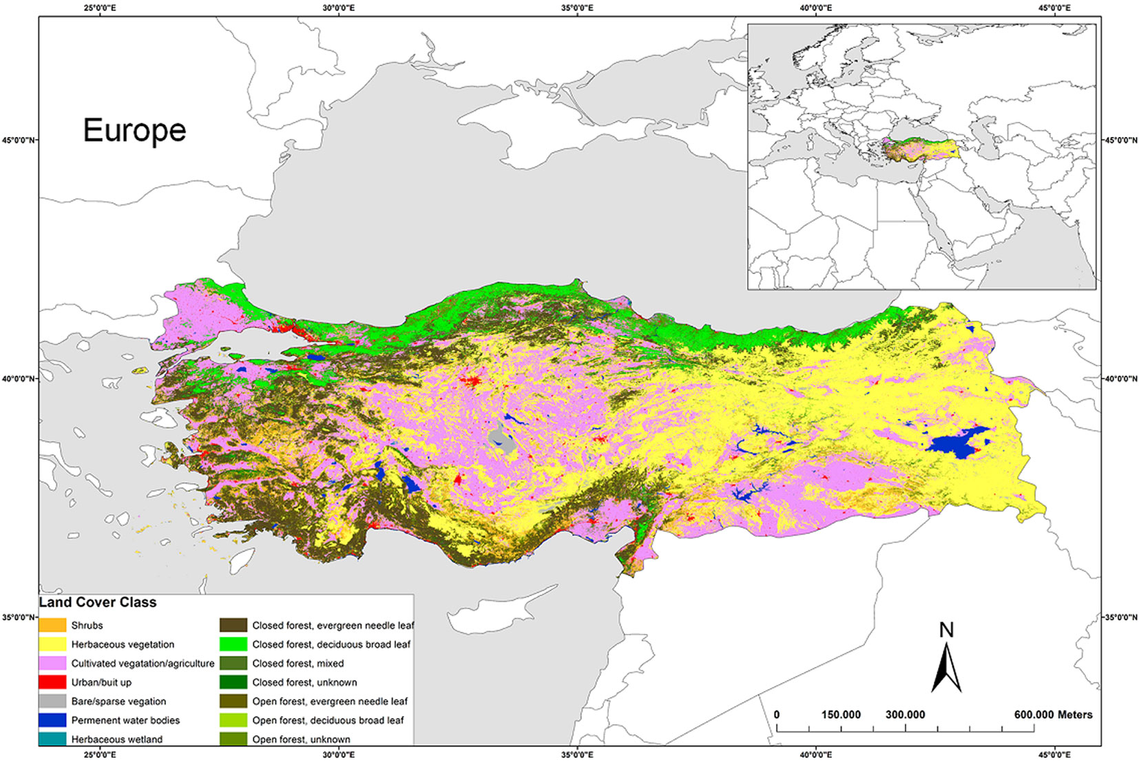
The study area is the mainland of Turkey (Fig. 1), located between latitudes 35° and 43° North, and longitudes 25° and 45° East. Turkey is a country with a land mass of 78,058 million ha, of which 22,741 million ha are forested ([20]), representing about 29 per cent of country’s total land area. About 12.5 million ha of forested lands is subjected to and under the threat of fires ([40]) and most fires occur where Mediterranean climate with high temperatures and low to nonexistent precipitation during wildfire season is predominant in the southern and western Anatolia. Fire season generally lasts from late May until mid-September in Turkey ([5], [40]). However, due to the increases in mean annual temperature in recent decades, fire season is prolonged in the southern regions, and the number of fires increased in the northeastern part of the country ([15]). Moreover, big fires (>50 ha) are more frequent than in the past in the Midwestern part of the Black sea region.
Fig. 1 - The geographic location and land cover classes according to the discrete classification of Land Cover Classification System (LCCS) of the study area in 2019 (mainland Turkey - ⇒ https://lcviewer.vito.be/2019/Turkey).
Land cover
The land cover was assessed using the European Space Agency (ESA) Copernicus Global Land Service (CGLS) Dynamic Land Cover Layers at 100 m resolution in the study area (Fig. 1). The discrete classification map including 14 classes was used for the years 2015, 2016, 2017, 2018 and 2019 ([6], [7], [8], [9], [10]) in the study area. A total of 14 land cover classes are available in Turkey, namely shrubs (6.02 %), herbaceous vegetation (36.8%), herbaceous wetland (0.12%), bare/sparse vegetation (0.81%), cropland (27.47%), urban/built up (1.55%), permanent water bodies (1.41%), open forests (evergreen needle-leaved (2.71%), deciduous broadleaved (0.06%) and unknown type (6.3%), and closed forests (evergreen needle-leaved (8.84%), deciduous broadleaved (5.04%), mixed type (0.65%) and unknown type (2.02%). These percentage values constitute the vegetation composition in 2019 ([10] - Fig. 1). Fire prone forested lands are mainly covered by evergreen needle-leaved pine species (i.e., Pinus brutia Ten. and Pinus nigra Arn.) and Mediterranean shrub plant communities -Maquis (i.e., Quercus coccifera L., Pistacia terebinthus L., Arbutus andrachne L., Myrtus communis L., Cistus spp.).
The spatial distribution of fires detected by MODIS and VIIRS S-NPP and performance assessment of active fire/hotspot products were analyzed on the land cover map of Turkey provided by Copernicus Global Land Service, Land Cover at 100 m spatial resolution. The raster land cover maps of the study area (20 × 20 degrees E020N40, E020N60, E040N40 and E040N60 at 100 m resolution) for the years 2015, 2016, 2017, 2018 and 2019 were downloaded from the European Space Agency (ESA) Copernicus Global Land Service: Land Cover 100 m open access database ([11]) as raster datasets ([14]). The raster layers were converted into shapefile polygons and then merged and clipped using the border of the study area. The conversion was performed using a GIS software (ArcGIS® v. 10.2, ESRI, Redlands, CA, USA).
Analyzing wildfires using MODIS and VIIRS S-NPP
Two types of fire products of NASA-FIRMS (Fire Information for Resource Management System) were used in the study: (i) Moderate Resolution Imaging Spectroradiometer (MODIS) active fire/hotspots; and (ii) Visible Infrared Imaging Radiometer Suite (VIIRS S-NPP). The MODIS (MCD14ML Collection 6 involving both the TERRA and AQUA satellites) archive daily fire datasets were downloaded as .csv files from the NASA-FIRMS websites covering the period of 2015-2019 for Turkey ([32]). The spatial resolution of the MODIS fire data was 1-km. Detection confidence of MODIS ranges from 0 to 100%, and above 30% is considered to have better accuracy ([24]). Therefore, the fires with a confidence value above 30% (nominal and high confidence) were used in the study.
The VIIRS S-NPP (VNP14IMG) archive daily fire datasets were downloaded as .csv files from the NASA-FIRMS websites ([32]) covering the period of 2015-2019 for Turkey. The spatial resolution of the fire data was 375 m. The VIIRS S-NPP fire detection resembles the MODIS algorithm approach by sampling a dynamically assigned window size to allow optimum characterization of the candidate fire pixel background ([42]).
The satellites take a “snapshot” of events as it passes over the earth. Each hotspot/active fire detection represents the center of a pixel flagged as containing one or more fires. For MODIS, the pixel size is approximately 1-km and for VIIRS S-NPP, the pixel size is approximately 375 m. The “location” is the center point of the pixel ([41], [24]). The fire datasets were converted into a shapefile point layer with the coordinates of each fire provided using a GIS software (ArcGIS® v. 10.2). The nominal and high detection confidence of the fires were used in this study ([41]). Some small number of detected fires on the water bodies (land cover code: 80 and 200) were masked.
Analyzing wildfires using the ground-based fire datasets for 2015-2019
The ground-based fire dataset covering the study periods were obtained from the General Directorate of Forestry (GDF), Forest Fire Service in Turkey. Fires have been documented by the GDF and include fire coordinates, region, starting time, duration, cause, average weather conditions, area burned and fire type, and stored in an online Fire Information System since 2013. This dataset is not open access, but only annual mean values can be downloaded from the GDF website ([20]). The GDF stores only the coordinates of fire starting points for the reported fires. The fire data set for the study period was obtained as .csv files from the GDF Fire Service. Then, fire locations were geo-referenced as a fire occurrence point layer in relation to the World Geodetic System (WGS) 1984 projection using the ArcGIS® v.10.2 platform. All fires were visually checked using Basemap - World Imagery with Labels tool in ArcGIS®, and those that lack or have incorrect coordinates were not included in the analyses. The same procedure was followed for the MODIS and VIIRS S-NPP fire data conversion.
Performance assessment of MODIS and VIIRS S-NPP with the ground based fire data
The performances of MODIS and VIIRS S-NPP active fire/hotspot detection products were assessed with the ground-based fire data in five land cover types; namely closed (land cover code: 111, 114, 115 and 116) and open forests (land cover code: 121, 124 and 126), shrubs (land cover code: 20), herbaceous vegetation (land cover code: 30) and cultivated vegetation/agriculture/cropland (land cover code: 40). In some studies, the performances of these products have been assessed for fires >1 ha ([19]). The initial assessment of ground-based fires indicated that nearly 78% (8613) of all fires were below 1 ha in size in five land cover types. Therefore, the performance assessment of the two products were conducted in three fire size classes to explore the accuracy of fire products in relation to the fire size and land cover. The ground-based fire dataset was divided into three fire size classes, namely: fire size <1 ha, 1 to 10 ha, and >10 ha. Fusco et al. ([19]) set a large spatial window to account for potential discrepancies in reporting fire locations as well as the differences in fire sizes reported. In this study, a buffer polygon with an extension equal to the burned area was created around each fire starting point to account for potential discrepancies in fire starting locations locally ([19]). All fires analyzed in all seasons between 2015 and 2019 were included in the analyses as the initial assessment of ground-based fire records indicated that detectable fires occurred all-year-round in five land cover types. The fires detected by MODIS and VIIRS S-NPP active fire/hotspot products with a confidence value above 30% (nominal and high confidence) were used in the study. The size of the buffers created were equaled to the spatial resolution ([48]) of the corresponding MODIS (1-km) and VIIRS S-NPP (375 m) active fire/hotspot products to represent the pixel size. To predict the producer’s accuracy and omission error of MODIS and VIIRS S-NPP active fire/hotspot detection products, the neighborhood of each ground-recorded fire was referred to the time of occurrence confirmed by ground-based fire records. For accuracy assessment in this study, reported ground fires detected by MODIS and VIIRS S-NPP were scored as “1” and those omitted as “0” samples ([48]). Note that, the performances of the two products were assessed in relation to the ground-based fire records detected positively by the two products ([19]) only, as the fires detected by fire/hotspot products may have not appeared in the GDF ground-based fire database due to a lack of reporting. Some fires may not have been reported if they were agricultural or prescribed fires far from the forests (unless they escape and become a forest fire that requires GDF action). Therefore, only the producer’s accuracy (%) and omission errors (%) were calculated for five different land cover classes. Then, the overall accuracy (%) was calculated as the total number of fires correctly detected by the MODIS and VIIRS S-NPP for five different land cover classes covering the study period divided by the total number of fires reported on the ground ([13]).
Results
MODIS, VIIRS S-NPP and GDF fire data distribution
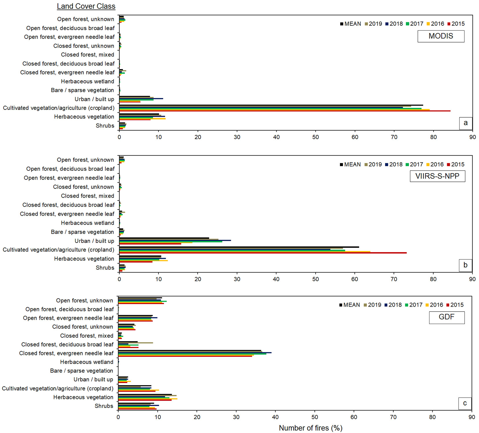
A total of 54.154 fires were detected by the MODIS during the period of 2015-2019 in the study area. Of these fires, 32.2%, 24.1%, 16.9%, 12.1% and 14.7% were in 2015, 2016, 2017, 2018 and 2019, respectively in 13 different land cover types (Tab. 1, Fig. 2a, Fig. 3a). The results indicated that most of the fires were in cultivated vegetation/agricultural land (78.9%) followed by herbaceous vegetation (9.8%) and urban (7.1%) areas. A total of 211.511 fires were detected by the VIIRS S-NPP during the period of 2015-2019 in the study area. Of these fires, 27.4%, 23.6%, 17.7%, 15.1% and 16.2% were in 2015, 2016, 2017, 2018 and 2019, respectively in 13 different land cover types (Tab. 1, Fig. 2b, Fig. 3b). The results indicated that most of the detected fires were in the cultivated vegetation/agricultural land (62.7%) followed by urban (21.8%) and herbaceous vegetation (10.6%) areas. A total of 11.261 fires ground-based fires were analyzed during the period of 2015-2019 in the study area. Of these fires, 17.4%, 24.1%, 19.1%, 17.6% and 21.8% were reported in 2015, 2016, 2017, 2018 and 2019, respectively in 13 different land cover types (Tab. 1, Fig. 2c, Fig. 3c). The results indicated that most of the fires were reported in the evergreen needle leaved closed forest (36.3%) followed by herbaceous vegetation (13.8%) and shrubland (9.1%).
Tab. 1 - Detected (MODIS and VIIRS S-NPP) and reported (GDF) fires in the Turkey between 2015 and end of 2019. (*): Map Code indicates the land cover types in discrete classification coding in Copernicus Global Land Service: Land Cover at 100m spatial resolution ([11]).
| Land Cover | Land Cover Class | Map Code * |
MODIS | VIIRS S-NPP | GDF | |||
|---|---|---|---|---|---|---|---|---|
| Total | % | Total | % | Total | % | |||
| Non-forest | Shrubs | 20 | 739 | 1.4 | 2802 | 1.3 | 1021 | 9.1 |
| Herbaceous vegetation | 30 | 5320 | 9.8 | 22322 | 10.6 | 1553 | 13.8 | |
| Cultivated vegetation/agriculture | 40 | 42703 | 78.9 | 132630 | 62.7 | 945 | 8.4 | |
| Urban / built up | 50 | 3845 | 7.1 | 46021 | 21.8 | 282 | 2.5 | |
| Bare / sparse vegetation | 60 | 88 | 0.2 | 1942 | 0.9 | 4 | 0.0 | |
| Herbaceous wetland | 90 | 62 | 0.1 | 301 | 0.1 | 9 | 0.1 | |
| Closed forest | Evergreen needle leaf | 111 | 425 | 0.8 | 1430 | 0.7 | 4086 | 36.3 |
| Deciduous broad leaf | 114 | 74 | 0.1 | 456 | 0.2 | 560 | 5.0 | |
| Mixed | 115 | 8 | 0.0 | 28 | 0.0 | 96 | 0.9 | |
| Unknown | 116 | 184 | 0.3 | 856 | 0.4 | 462 | 4.1 | |
| Open Forest | Evergreen needle leaf | 121 | 134 | 0.2 | 387 | 0.2 | 985 | 8.7 |
| Deciduous broad leaf | 124 | 1 | 0.0 | 16 | 0.0 | 7 | 0.1 | |
| Unknown | 126 | 571 | 1.1 | 2320 | 1.1 | 1251 | 11.1 | |
| Total | - | - | 54154 | 100 | 211511 | 100 | 11261 | 100 |
Fig. 2 - MODIS MCD14LM, VIIRS S-NPP-375m and GDF fire data distribution for the period 2015-2019 in the study area (mainland Turkey).
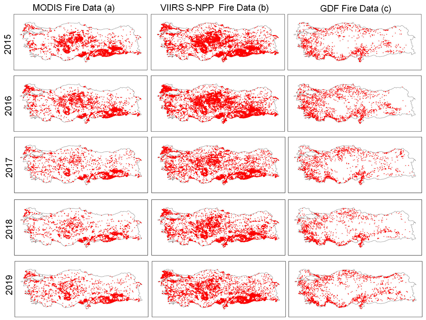
Fig. 3 - MODIS MCD14LM, VIIRS S-NPP-375m and GDF number of fires on the land cover classes for the period 2015-2019 in the study area (mainland Turkey).
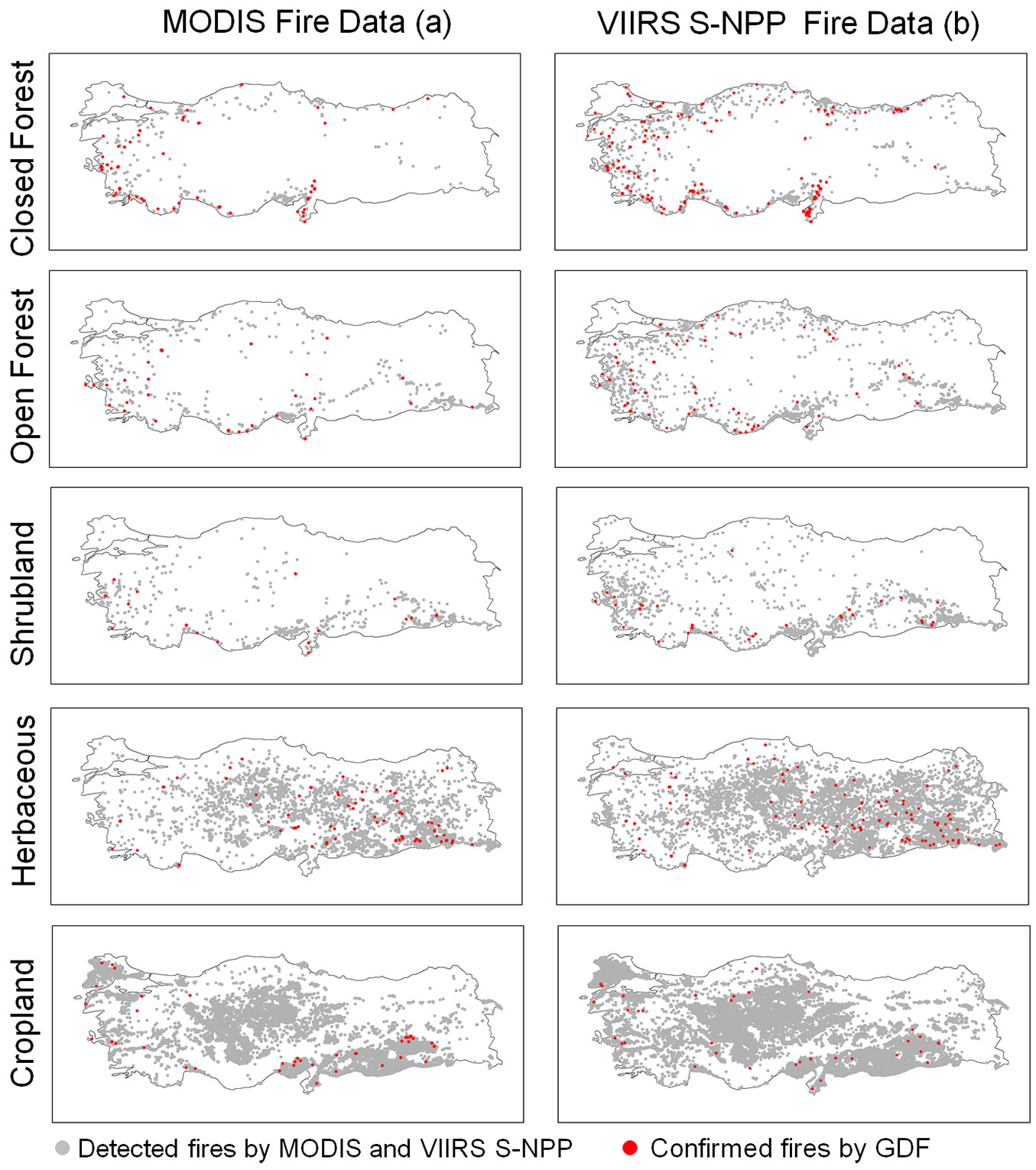
The results of the distribution of detected fires in five land cover types during the study period indicated that a total of 691, 706, 739, 5320 and 42,703 fires were detected by MODIS (Tab. 1, Fig. 4a) and a total of 2770, 2723, 2802, 22,322 and 132,630 fires were detected by VIIRS S-NPP in closed and open forest areas, shrublands, herbaceous vegetation and croplands, respectively (Tab. 1, Fig. 4b). For the same period, a total of 5204, 2243, 1021, 1553 and 945 ground based fires were reported by GDF in closed and open forest areas, shrublands, herbaceous vegetation and croplands, respectively (Tab. 1). The number of fires <1 ha, 1 to 10 ha and >10 ha corresponded to 78.5%, 17.5% and 4.0%, with the mean fire sizes being 0.18, 3.20, and 70.60 ha, respectively for all ground based fires in five land cover classes (Tab. 2).
Fig. 4 - The geographic locations of all detected and confirmed with GDF MODIS (a) and VIIRS S-NPP-375m (b) fires in the closed forested (Land cover code: 111, 114, 115 and 116) and open forested lands (Land cover code: 121, 124 and 126), shrubs (land cover code: 20), herbaceous vegetation (land cover code: 30) and croplands (land cover code: 40) in Turkey between 2015 and 2019.
Tab. 2 - The number and the mean size (in parenthesis) of reported fires in closed and open forests, shrublands, herbaceous vegetation and croplands according to the fire size classes. Land Cover Classes (LCC): (CF) Closed Forests; (OF) Open Forests; (S) Shrublands; (HV) Herbaceous Vegetation; (C) Croplands.
| Ground-based Fires |
Land Cover Classes | Total (Mean size, ha) |
||||
|---|---|---|---|---|---|---|
| CF | OF | S | HV | C | ||
| <1 ha | 4444 (0.16) | 1853 (0.18) | 737 (0.21) | 897 (0.28) | 682 (0.22) | 8613 (0.18) |
| 1-10 ha | 634 (3.12) | 323 (3.10) | 227 (3.22) | 520 (3.42) | 220 (3.00) | 1924 (3.20) |
| >10 ha | 126 (114.76) | 67 (68.30) | 57 (73.36) | 136 (38.14) | 43 (48.83) | 429 (70.60) |
| Total | 5204 (3.29) | 2243 (2.64) | 1021 (4.97) | 1553 (4.64) | 945 (2.85) | 10966 (3.47) |
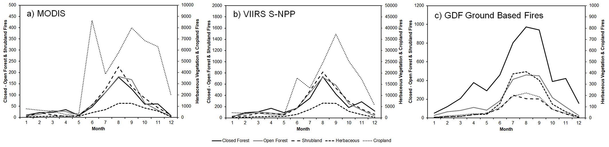
The results showed that the fires in closed and open forests, shrublands and herbaceous vegetation were detected by MODIS and VIIRS S-NPP from May to November with the peak values recorded in August in the study area. The fires in croplands were detected by fire products from June to October with the peak values recorded in June and September. The spatial distributions of fires detected by MODIS and VIIRS S-NPP in croplands revealed that most of the fires were mainly concentrated in the middle and southeastern part of the country (Fig. 5a, Fig. 5b). The results indicated the trend of the monthly distribution of the reported fires by GDF were similar to those of fire detection products (Fig. 5c).
Fig. 5 - The monthly distribution of detected MODIS (a) and VIIRS S-NPP (b) and GDF-reported (c) number of fires on closed and open forest areas, shrublands, herbaceous vegetation and croplands during the period of 2015- 2019 in Turkey.
Performance analysis of MODIS and VIIR S-NPP in different land cover types in relation to the area burned
The performance assessment of MODIS and VIIRS S-NPP was conducted in relation to the fire size classes (fire size <1 ha, 1 to 10 ha, and >10 ha) in five land cover types; closed and open forest areas, shrublands, herbaceous vegetation and croplands during the period of 2015-2019 in the study area (Tab. 3). The performance analysis of MODIS indicated that 13 fires in closed and 8 fires in open forests, 3 fires in shrublands, 13 fires in herbaceous vegetation and 14 fires in croplands out of 4444, 1853, 737, 897 and 682 ground-based fires <1 ha in size in these land cover types were positively detected, respectively. The producer’s accuracy (PA) were 0.3%, 0.2%, 0.1%, 0.3% and 0.3% in closed and open forest areas, shrublands, herbaceous vegetation and croplands, respectively (Tab. 3, Fig. 6a). The overall accuracy of MODIS fire/hotspot product was 0.6% for the study period. The performance analysis of VIIRS S-NPP indicated that only 35 fires in closed and 21 fires in open forests, 8 fires in shrublands, 26 fires in herbaceous vegetation, and 21 fires in croplands out of 4444, 1853, 737, 897 and 682 ground-based fires <1 ha in size in these land cover types were positively detected, respectively. The PA were 0.8%, 1.1%, 1.1%, 2.3% and 3.1% in closed and open forest areas, shrublands, herbaceous vegetation and croplands, respectively (Tab. 3, Fig. 6a). The overall accuracy of VIIRS S-NPP fire/hotspot product was 1.3% for the study period.
Tab. 3 - The number of reported fires by GDF and confirmed detection in closed and open forests, shrublands, herbaceous vegetation and croplands by the MODIS and VIRRS S-NPP during the study period. (OE): omission error (%); (PA): producer’s accuracy (%); (OA): overall accuracy (%).
| Size of burned area (total no.) |
Source | Land Cover | CF | OF | S | HV | C | OA (%) |
|---|---|---|---|---|---|---|---|---|
| <1 ha (8613) |
MODIS | Reported | 4444 | 1853 | 737 | 897 | 682 | 0.6 |
| Detected | 13 | 8 | 3 | 13 | 14 | |||
| OE (%) | 99.7 | 99.8 | 99.9 | 99.7 | 99.7 | |||
| PA (%) | 0.3 | 0.2 | 0.1 | 0.3 | 0.3 | |||
| VIIRS S-NPP | Detected | 35 | 21 | 8 | 26 | 21 | 1.3 | |
| OE (%) | 99.2 | 98.9 | 98.9 | 97.1 | 96.9 | |||
| PA (%) | 0.8 | 1.1 | 1.1 | 2.9 | 3.1 | |||
| 1-10 ha (1924) |
MODIS | Reported | 634 | 323 | 227 | 520 | 220 | 3.2 |
| Detected | 14 | 8 | 8 | 20 | 12 | |||
| OE (%) | 97.8 | 97.5 | 96.5 | 96.2 | 94.5 | |||
| PA (%) | 2.2 | 2.5 | 3.5 | 3.8 | 5.5 | |||
| VIIRS S-NPP | Detected | 62 | 17 | 15 | 43 | 12 | 7.7 | |
| OE (%) | 90.2 | 94.7 | 93.4 | 91.7 | 94.5 | |||
| PA (%) | 9.8 | 5.3 | 6.6 | 8.3 | 5.5 | |||
| >10 ha (429) |
MODIS | Reported | 126 | 67 | 57 | 136 | 43 | 16.6 |
| Detected | 24 | 10 | 5 | 27 | 5 | |||
| OE (%) | 81.0 | 85.1 | 91.2 | 80.1 | 88.4 | |||
| PA (%) | 19.0 | 14.9 | 8.8 | 19.9 | 11.6 | |||
| VIIRS S-NPP | Detected | 54 | 17 | 8 | 26 | 5 | 25.6 | |
| OE (%) | 57.1 | 74.6 | 86.0 | 80.9 | 88.4 | |||
| PA (%) | 42.9 | 25.4 | 14.0 | 19.1 | 11.6 |
Fig. 6 - The accuracy assessment (%) of MODIS and VIIRS S-NPP-375m with the ground based fires <1 ha (a), from 1 to 10 ha (b), and >10 ha (c) on the closed and open forests, shrublands, herbaceous vegetation and croplands for the period of 2015-2019.
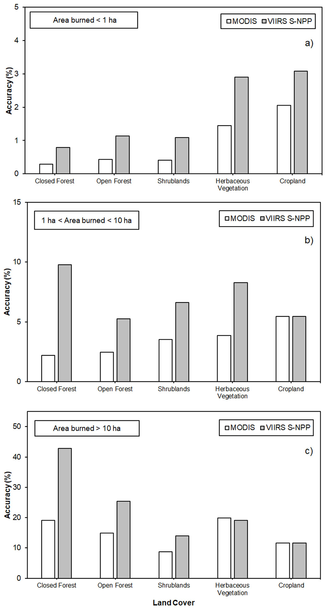
The performance analysis of MODIS indicated that 14 fires in closed and 8 fires in open forests, 8 fires in shrublands, 20 fires in herbaceous vegetation, and 12 fires in croplands out of 634, 323, 227, 520 and 220 ground-based fires from 1 to 10 ha in size in these land cover types were positively detected, respectively (Tab. 3). The PA were 2.2%, 2.5%, 3.5%, 3.8% and 5.5% in closed and open forest areas, shrublands, herbaceous vegetation and croplands, respectively (Tab. 3, Fig. 6b). The overall accuracy of MODIS fire/hotspot product was 3.2% for the study period. The performance analysis of VIIRS S-NPP indicated that 62 fires in closed and 17 fires in open forests, 15 fires in shrublands, 43 fires in herbaceous vegetation, and 12 fires in croplands out of 634, 323, 227, 520 and 220 ground-based from 1 to 10 ha in size in these land cover classes were positively detected, respectively. The PA were 9.8%, 5.3%, 6.6%, 8.3% and 5.5% in closed and open forest areas, shrublands, herbaceous vegetation and croplands, respectively (Tab. 3, Fig. 6b). The overall accuracy of VIIRS S-NPP fire/hotspot product was 7.7% for the study period.
The performance analysis of MODIS indicated that 24 fires in closed and 10 fires in open forests, 5 fires in shrublands, 27 fires in herbaceous vegetation, and 5 fires in croplands out of 126, 67, 57, 136 and 43 ground-based fires >10 ha in size in these land cover classes were positively detected, respectively. The PA were 19.0%, 14.9%, 8.8%, 19.9% and 11.6% in closed and open forest areas, shrublands, herbaceous vegetation and croplands, respectively (Tab. 3, Fig. 6c). The overall accuracy of MODIS fire/hotspot product was 16.6% for the study period. The performance analysis of VIIRS S-NPP indicated that 54 fires in closed and 17 fires in open forests, 8 fires in shrublands, 26 fires in herbaceous vegetation, and 5 fires in croplands out of 126, 67, 57, 136 and 43 ground-based fires >10 ha in size in these land cover classes were positively detected, respectively. The PA were 42.9%, 25.4%, 14.0%, 19.1% and 11.6% in closed and open forest areas, shrublands, herbaceous vegetation and croplands, respectively (Tab. 3, Fig. 6c). The overall accuracy of VIIRS S-NPP fire/hotspot product was 25.6 % for the study period.
Discussion
Analyzing the wildfires using MODIS and VIRRS S-NPP
The NASA-FIRMS fire products have been used in the scientific literature available more than any other global fire dataset ([31]). Several studies have been conducted to analyze active fires ([33], [19], [25], [48], [47]) and burned areas ([45], [1], [29]) using MODIS and VIIRS fire products. The results of the present study revealed that the number of fires detected by VIIRS S-NPP was nearly 4 times the fires detected by MODIS from 2015 to end of 2019 in the study area (Tab. 1). The variation in the number of fires may be attributed to the difference in the technical specifications of the sensors. Improved spatial resolution and algorithm for fire detection enables VIIRS S-NPP to detect smaller fires than does MODIS ([42], [33]). Although significant variations exist in the number of fires detected by MODIS and VIIRS S-NPP, the distribution of the fires on the land cover types were almost similar (Fig. 3a, Fig. 3b). The results showed that over 95% of all the fires detected by the MODIS and VIIRS S-NPP were in three land cover types, namely: cultivated vegetation/agriculture, urban and herbaceous vegetation areas (Tab. 1, Fig. 3a, Fig. 3b). These type of land covers are open and relatively homogenous as compared to the forest areas or woody shrublands. Therefore, the fires in these lands provide favorable observing conditions for fire detection for the MODIS and VIIRS S-NPP ([24]).
As the Fig. 2a and Fig. 2b indicate, the detected fires were mainly concentrated in the central (Central Anatolia Region) and southeastern (Southeastern Anatolia Region) part of the country where agricultural croplands extent throughout the landscape (Fig. 1), where farmers traditionally burn the stubble after harvest. Therefore, it seems that most of the fires detected by the two fire products in these lands may have been the fires occurring in agricultural lands. The stubble or residue burnings are mainly conducted in September in Turkey and the peak in the number of fires detected by the MODIS and VIIRS S-NPP coincides with the period of intentional burnings (Fig. 5a, Fig. 5b). This may explain most of the points detected especially in Central and Southeastern Anatolia ([3]). The peak shown in June in MODIS fire data (Fig. 5a) in croplands is not supported by any ground data. There is no major fire activity in June in the country. A possible explanation may be related to warm surfaces of open farmlands resulting in false alarm in MODIS. False alarms in MODIS are constrained to daytime data when differential solar reflection and heating can sometimes lead to ambiguous classification of land surface pixels ([22]). Only a small portion of agricultural fires have been reported and listed in the GDF dataset (Tab. 1). This may account for the significant differences in the number of fires reported by GDF and those observed by the MODIS and VIIRS S-NPP.
Fire detection performance in relation to fire size and land cover classes
The results indicated that the performances of MODIS and VIIRS S-NPP in fire detection in small sized fires (<1 ha) were very low (Tab. 3, Fig. 6a). The ground based fire data showed that 78.5% of all ground-based fires were <1 ha. Of these, 73.1% of fires were in the forested (closed and open) areas (Tab. 3). These fires were small-sized and mainly surface fires with low fire intensity under tree canopy. This may be acceptable, because as outlined in the user’s guide of the MODIS ([24]), the fire detection capability of MODIS beneath a tree canopy is unknown or probably very low. In addition, the fire detection performances of the two products in shrublands, herbaceous vegetation and croplands were also low (Tab. 3, Fig. 6a). One of the major reasons could be attributed to small fire size ([50]), duration of fires and lower fire intensities due to low fuel loads. Moreover, the fires may have started and ended in between satellite overpasses ([24]). Similar results were obtained from the VIIRS S-NPP in the forested lands (Fig. 6a) in the study period. However, the performance of VIIRS S-NPP in the detection of fires was better than that of MODIS. This may be attributed to the high spatial resolution and improved fire detection algorithm employed in VIIRS S-NPP ([42]).
As the fire size increased, the accuracy of MODIS and VIIRS S-NPP increased in all land cover classes (Tab. 3, Fig. 6b, Fig. 6c). The high producer’s accuracy in VIIRS S-NPP was obtained in the fires >10 ha in closed forest (42.9% - Fig. 6c). The fire size, fire intensity, fire severity and duration of these fires were high, generating more hotspots than shrublands, herbaceous vegetation and croplands ([36]). Moreover, MODIS and VIIRS S-NPP active fire products detect hotspots, it is likely that fires with larger final fire sizes have a higher likelihood of detection because, these products have more detection opportunities ([19]) as fires continue to burn and increase in size.
The results indicated that for the 10,966 confirmed ground-based fire records in five different land cover types, the overall accuracy of MODIS ranged from 0.6% to 16.6% and VIIRS S-NPP from 1.3% to 25.6% of all ground-based fires (Tab. 3, Fig. 6). Similar results were obtained in a study from U.S. where MODIS product detection rates ranged from 3.5% to 23.4% of all documented agency wildfires >1 ha in size ([19]). Similar results were also reported in a study from Yunnan province of China with nearly 90% omission in forest areas ([48]).
Analyzing the forest fires using the GDF fire data
The results indicated that most of the fires were in the forested lands (66.1%) (Tab. 1). Fires mainly took place in the western and southern parts of the country (Fig. 2c) where the majority of the areas are covered by closed evergreen needle leaved forests, herbaceous vegetation, shrublands and unknown open forests (Fig. 1). Most of the fires were reported in the evergreen needle leaved closed forest (36.3%) followed by herbaceous vegetation (13.8%), unknown open forests (11.1%) and shrublands (9.1%) in the country for the study period (Tab. 1). Evergreen needle leaved forests are mainly dominated by the Calabrian pine (Pinus brutia Ten.) and Anatolian black pine (Pinus nigra Arn.) stands. Shrublands are mainly composed of the Mediterranean shrub plant communities - maquis (i.e., Quercus coccifera L., Pistacia terebinthus L., Arbutus andrachne L., Myrtus communis L., and Cistus spp.). The land cover classified as “unknown open forests” in the Land Cover Classification System (LCCS - [11]) are mainly covered by the Calabrian pine dominated open stands. The canopy closure of the open stands is less than 10% and dominated by the Calabrian pine with the Mediterranean shrub plant communities (maquis) in the understory. The LCC system classifies the forests with the canopy closure more than 15% as open forests ([11]). These kind of areas do not match with any of the other definitions in the LCC system.
The forest fire prone areas in the country are mainly covered by the Calabrian pine dominated stands and maquis, and many studies were conducted to predict forest fire risk and danger in different regions in Turkey ([38], [43]). In some studies, model validation was performed using the NASA-FIRMS products ([12]). However, these products (particularly MODIS) have some limitations in detecting small scale fires under closed forest canopy conditions as confirmed by the results of this study (Tab. 3, Fig. 6a, Fig. 6b). Therefore, the use of MODIS and VIIRS S-NPP active fire/hotspot data in the validation of forest fire risk and danger prediction models irrespective of land cover may lead to incorrect results. Also, the intentional stubble or residual burnings in agricultural lands may negatively affect the validation of the models. Although these products can be useful and accurate to detect large scaled and intense fires with high fuel load, some limitations of these fire products exist in the assessment of small scaled (i.e., <10 ha) fires in especially closed forested areas. However, the results of this study provide no conclusive evidence for the performances of MODIS and VIIRS S-NPP active fire/hotspot products in fire detection in the Mediterranean region. The performances were assessed only with the positive detection of ground-based fire records provided by GDF. Potential discrepancies of reported fire locations, starting time and size of fires might affect the performance assessment of active fire/hotspot products. Moreover, the fire detection performances in different land cover classes may be affected by the classified land cover map of Turkey provided by Copernicus Global Land Service for the study period. Therefore, new studies should be conducted to assess the performances of the active fire/hotspot products in the Mediterranean region.
Conclusion
In this study, the performance of MODIS and VIIRS S-NPP active fire/hotspot products in fire detection in different land cover types were assessed using the ground-based fire data between 2015 and 2019 in Turkey. The majority of the fires took place in the western and southern part of the country, where Calabrian pine, Anatolian black pine and Mediterranean shrub plant communities are the dominant vegetation cover. The performances of the two active fire/hotspot products were assessed in relation to the ground-based fire records detected positively by the MODIS and VIIRS S-NPP. The overall accuracy of MODIS ranged from 0.6% to 16.6% and VIIRS S-NPP from 1.3% to 25.6% of all ground-based fires in five different land cover types. The detection rates increased as the fire size increased. This study showed that some limitations exist in the use of MODIS and VIIRS S-NPP active fire/hotspot products in the assessment of wildfires particularly <10 ha in size. The results of the comparison of MODIS vs. VIIRS S-NPP active fire/hotspot products and ground-based GDF fires provided no conclusive evidence to suggest that these products could be successfully used in wildland fire detection under closed canopy conditions. Thus, further studies should be conducted with the methodological approach presented in this study in different geographical locations where wildfires are common.
Acknowledgements
The author would like to extend his appreciation and thanks to General Directorate of Forestry - Forest Fire Service in Turkey and its staff for making available ground-based fire database for the present study.
Conflict of interest
The author declare that he has no conflict of interest.
References
Gscholar
Gscholar
Gscholar
Gscholar
CrossRef | Gscholar
CrossRef | Gscholar
Gscholar
Gscholar
Gscholar
Gscholar
Authors’ Info
Authors’ Affiliation
Karadeniz Technical University, Faculty of Forestry, 61080, Trabzon (Turkey)
Corresponding author
Paper Info
Citation
Coskuner KA (2022). Assessing the performance of MODIS and VIIRS active fire products in the monitoring of wildfires: a case study in Turkey. iForest 15: 85-94. - doi: 10.3832/ifor3754-015
Paper history
Received: Jan 16, 2021
Accepted: Jan 31, 2022
First online: Mar 19, 2022
Publication Date: Apr 30, 2022
Publication Time: 1.57 months
Copyright Information
© SISEF - The Italian Society of Silviculture and Forest Ecology 2022
Open Access
This article is distributed under the terms of the Creative Commons Attribution-Non Commercial 4.0 International (https://creativecommons.org/licenses/by-nc/4.0/), which permits unrestricted use, distribution, and reproduction in any medium, provided you give appropriate credit to the original author(s) and the source, provide a link to the Creative Commons license, and indicate if changes were made.

Web Metrics
Breakdown by View Type
Article Usage
Total Article Views: 63681
(from publication date up to now)
Breakdown by View Type
HTML Page Views: 44889
Abstract Page Views: 9013
PDF Downloads: 9123
Citation/Reference Downloads: 37
XML Downloads: 619
Web Metrics
Days since publication: 1586
Overall contacts: 63681
Avg. contacts per week: 281.06
Article Citations
Article citations are based on data periodically collected from the Clarivate Web of Science web site
(last update: Mar 2025)
Total number of cites (since 2022): 18
Average cites per year: 4.50
Publication Metrics
by Dimensions ©
Articles citing this article
List of the papers citing this article based on CrossRef Cited-by.
Related Contents
iForest Similar Articles
Review Papers
Remote sensing-supported vegetation parameters for regional climate models: a brief review
vol. 3, pp. 98-101 (online: 15 July 2010)
Review Papers
Accuracy of determining specific parameters of the urban forest using remote sensing
vol. 12, pp. 498-510 (online: 02 December 2019)
Review Papers
Remote sensing of selective logging in tropical forests: current state and future directions
vol. 13, pp. 286-300 (online: 10 July 2020)
Research Articles
Afforestation monitoring through automatic analysis of 36-years Landsat Best Available Composites
vol. 15, pp. 220-228 (online: 12 July 2022)
Review Papers
Remote sensing support for post fire forest management
vol. 1, pp. 6-12 (online: 28 February 2008)
Technical Reports
Detecting tree water deficit by very low altitude remote sensing
vol. 10, pp. 215-219 (online: 11 February 2017)
Research Articles
Fuel type characterization based on coarse resolution MODIS satellite data
vol. 1, pp. 60-64 (online: 28 February 2008)
Research Articles
Mapping the vegetation and spatial dynamics of Sinharaja tropical rain forest incorporating NASA’s GEDI spaceborne LiDAR data and multispectral satellite images
vol. 18, pp. 45-53 (online: 01 April 2025)
Research Articles
Evaluation of hydrological and erosive effects at the basin scale in relation to the severity of forest fires
vol. 12, pp. 427-434 (online: 01 September 2019)
Research Articles
Assessing water quality by remote sensing in small lakes: the case study of Monticchio lakes in southern Italy
vol. 2, pp. 154-161 (online: 30 July 2009)
iForest Database Search
Search By Author
Search By Keyword
Google Scholar Search
Citing Articles
Search By Author
Search By Keywords
PubMed Search
Search By Author
Search By Keyword


