Comparing multisource harmonized forest types mapping: a case study from central Italy
iForest - Biogeosciences and Forestry, Volume 8, Issue 1, Pages 59-66 (2015)
doi: https://doi.org/10.3832/ifor1133-007
Published: Jun 17, 2014 - Copyright © 2015 SISEF
Research Articles
Abstract
The availability of common standardized geospatial information on composition, structure and distribution of forests is essential to support environmental actions, sustainable forest management and planning policies. Forest types maps are suitable tools for supporting both silvicultural and forest planning choices from local to global scale levels. For this reason local authorities may develop forest types maps independently, in which case a standardized/harmonized framework for their comparison and aggregation is essential. At the same time local forest types maps may not be directly related to pan-European forest resources assessments and classification systems. This paper presents results of the harmonization of four forest types maps available for central Italy. The process is based on a bottom-up approach aimed at maintaining the most detailed common nomenclature system across the different Regions. The final results, in terms of forest types area, are compared with several independent sources of information: (i) two forest maps, one developed at national level on the basis of the Corine Land Cover 2006, and one for high resolution forest / non forest classification developed at pan-European level; and (ii) two sample based inventories: the Italian National Forest Inventory (INFC) and the Italian Land Use Inventory (IUTI). The results show that the proposed bottom- up harmonization approach is a suitable tool to guarantee the integrity and homogeneity of local forest types nomenclature systems, and to integrate such local data with European standards.
Keywords
Forest Categories, Forest Types, Central Italy, Forest Area Estimation, Forest Nomenclature Systems, Forest Resources Classification, Forest Resources Mapping
Introduction
Forest types
Information on the distribution and characteristics of forest ecosystems is essential to support decision makers for a correct implementation of Sustainable Forest Management (SFM) and to optimize the provisioning of ecosystem services ([26]). The use of standardized multi-scale nomenclature systems to describe the characteristics of forests is necessary to facilitate the integration of forest ecosystem planning, usually developed for large regional and continental areas, with forest management strategies developed at local level.
In such a framework the Forest Types (FTs) approach, originally developed in Italy two decades ago ([14]), is nowadays frequently adopted as a nomenclature system for forest classification, since FTs can be directly related to silvicultural treatments and other ecological forest characteristics. A FT can be described as “a category of forest defined by its composition, and/or site factors (locality), as categorized by each country in a system suitable to its situation” ([6]). This concept embraces all forest classification systems that allow a hierarchical assessment of forest stands through a synoptic evaluation of both vegetation composition (floristic and/or phytosociological) and ecological-silvicultural characteristics ([12]).
FTs classification systems are usually organized according to a hierarchical structure: the main level is based on types which are grouped in categories usually on the basis of the main dominant tree species, types may be optionally further divided in subtypes or variants.
FTs are commonly assessed at stand level to be consistent with the scale of forest resource management units ([10]), but they are also frequently used as a system of nomenclature of forest maps created on the basis of remotely sensed data.
At a continental level, the European Environmental Agency ([16]) published a first version of a European Forest Types (EFTs) system that was adopted by Forest Europe/UNECE/FAO ([19]) for reporting a large set of SFM indicators for European countries. The EFTs were recently revised with minor adjustments in Barbati et al. ([3]).
Forest types area assessment in Italy
Forest resource assessments can be applied using two principal methodologies: (i) forest inventory based on the investigation of a small part of the interested region in the form of a sample, the result is an aggregated statistic for the whole region or for a subpart of it; and (ii) forest mapping, that is nowadays based on the elaboration of remotely sensed data to investigate the entire region of interest. The result is a geographical depiction of the location of forest and related attributes ([8]).
Currently there are several independent sources of information available in Italy for estimating forest area, which are all based on different systems of classification. Following is a brief description of the state of the art in this field.
The second Italian National Forest Inventory (INFC 2005 - Inventario Nazionale delle Foreste e dei serbatoi forestali di Carbonio) provided the estimation of forest area on a nomenclature system structured into 17 forest categories (FCs), further divided in 91 sub-categories (Sub-Cs - [33]). INFC was based on a three-phase sampling design: the first phase was carried out on the basis of digital aerial orthophotos on a total of approximately 300 000 sampling units distributed on the basis of a tessellated random sampling, while the second and third phases were based on field work. The forest definition adopted was the same used by FAO ([17]).
More recently the Italian Land Use Inventory (IUTI - Inventario dell’Uso delle Terre in Italia) sought to estimate the area coverage of six land use categories (including “Forest land” - [9]). The IUTI project, according to the GPG-LULUCF guidelines ([29]), was carried out by manual classification of sampling units distributed on the basis of a tessellated random sampling ([18]) superimposed on digital aerial orthophotos. The forest definition adopted in IUTI was the same as that of the INFC.
Both INFC and IUTI projects provided estimates, with confidence intervals, at country level and for NUTS2 administrative units (called “Regions” in Italy).
In central Italy, FTs maps are currently available for many Regions: Tuscany ([22]), Marche ([24], [28]), Lazio ([7]), Abruzzo ([11]) and Molise ([20]). Those from Marche, Lazio, Abruzzo and Molise were all developed using the same methodology and adopted the same forest definition as that used by INFC and IUTI, with the same scale (1:10 000) and the same Minimum Mapping Unit (MMU) of 0.5 ha. But the four maps adopted different nomenclatures all based on forest categories subdivided in types.
In Italy, the Corine Land Cover (CLC) 2000 and 2006 maps were developed refining the original European nomenclature system. The standard forest classes (broadleaved/coniferous/mixed) were detailed in 14 FCs based on dominant species. The CLC maps were developed by manual delineation of multispectral satellite images, with a scale of 1:100 000 and a MMU of 25 ha ([30]).
At pan-European level, the European Commission’s Joint Research Centre (JRC) developed FMAP2006 and FTYP2006, a high resolution (pixel of 25 m) forest, non-forest map and a forest type map derived from the IMAGE2006 database, MODIS data and the CLC2006 map as training data ([25]).
It is important to note that in Italy the vegetation was recently classified by Blasi ([4]) into 240 series, 37 vegetation mosaics, 39 geo-series (sigmeta), which were then reassembled into 279 legend classes. The system resulted from the integration of two processes: (i) land units obtained through a hierarchical land classification; and (ii) vegetation series defined using phytosociological field data and the expert knowledge of the relationships between present vegetation communities, environmental factors and vegetation dynamics.
Finally, forest habitats can be also classified according to the CORINE habitat nomenclature system that is based on a total of 230 classes ([1]).
The aim of this contribution
The topic of contrasting different information sources for forest area assessment is relevant both for the scientific community and for forest managers and decision-makers. Such an interest was clearly demonstrated at a pan-European level by Seebach et al. ([31]) when country level forest area estimates were calculated on the basis of different sources of information, including NFIs and CLC maps.
Since the different monitoring projects available in Italy (INFC, IUTI, CLC and JRC forest / non-forest map, local forest maps) were developed independently of each other, the problem of harmonizing the different nomenclature systems across the different administrative Regions was extremely relevant. In the framework of the approach recently proposed by Ståhl et al. ([32]), the comparison of forest information acquired on the basis of different definitions can be approached through the use of “harmonization bridges” ([27]). The harmonization approach can be seen as a method to maintain the characteristics of local data which are based on different definitions and methods enabling their comparability at a higher hierarchical level on the basis of commonly agreed reference definitions.
The aim of this paper is to first present the development of bridges to create a harmonized high resolution FTs map (scale 1:10 000, MMU of 0.5 ha) based on local maps available in a study area in central Italy that includes the administrative Regions of Marche, Abruzzo, Lazio and Molise. This approach produced on a harmonized nomenclature system with relationships with other existing systems: INFC, CLC06, EFTs, vegetation of Italy ([4]) and CORINE biotopes. Subsequently we compared the resulting harmonized FTs area estimations based on local high resolution forest maps with those resulted from other independent sources: the Italian National Forest Inventory ([23]), and the CLC06 classes ([30]). The same test was repeated comparing forest / non-forest area estimations, including the results obtained from IUTI and the JRC map.
Materials and methods
Materials
The study area covers a total of 42 246 km2 and includes four administrative Regions located in central Italy: Marche, Abruzzo, Lazio, and Molise. The elevation ranges from sea level to the top of Gran Sasso (2914 m a.s.l.), the highest peak of the Apennine mountain range. The climate in the study area is mainly Mediterranean and temperate with precipitations concentrated in spring and autumn.
For the study area, four regional high resolution forest maps were used. The maps were originally produced at a scale of 1:10 000, with a MMU of 0.5 ha, and are all based on the manual delineation of digital orthophotos acquired in the period 2001-2007, integrated with field assessment (Tab. 1).
Tab. 1 - Main characteristics of the local FTs maps used in the study.
| Region | Regional area (ha) | Reference year |
Forest area (ha) |
Percent of forest cover |
|---|---|---|---|---|
| Abruzzo | 1 083 004 | 2005 | 454 017 | 41.9 |
| Lazio | 1 722 620 | 2007 | 619 575 | 35.9 |
| Marche | 972 860 | 2001 | 256 620 | 26.3 |
| Molise | 446 107 | 2004 | 157 609 | 35.3 |
The formal accuracy of these maps is unknown but they are all released with a certified thematic accuracy of at least 85%, according to the well-known international standard originally proposed by Anderson et al. ([2]). The four maps adopt the same forest definition from the FAO ([17]) but different nomenclature systems: in Abruzzo 32 FTs grouped in 12 FCs ([11]); in Lazio 36 FTs grouped in 16 FCs ([7]); in Marche 42 FTs grouped in 11 FCs ([24]); in Molise 40 FTs and 14 FCs ([20]).
The CLC06 forest map and the 2006 JRC high resolution forest / non-forest map, both available on-line, were clipped to the extent of the four administrative Regions. Finally the aggregated statistics of forest area for the different FCs of the National Forest Inventory (INFC - [21]) and for the forest area from the IUTI project were acquired.
Methods
The methodology adopted to harmonize the FTs nomenclature systems of the different dataset available in the study area follows a bottom-up approach, from local to European level, and from FTs to FCs. Fig. 1 presents an overview of the whole methodological framework adopted to harmonize the FTs systems.
Fig. 1 - Bottom-up approach adopted to harmonize FTs nomenclature systems. The flowchart shows the bottom-up approach adopted to harmonize FTs nomenclature systems at regional, national and European levels. From bottom to top, the arrows show the corresponding directions followed to harmonize the different FTs nomenclature systems at each step.
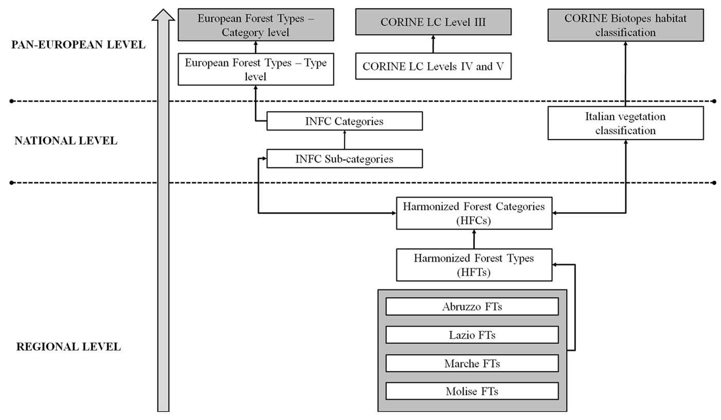
Firstly the four FTs systems from the high resolution forest maps of Marche, Abruzzo, Lazio and Molise were compared and a new reference system, called Harmonized Forest Types Nomenclature System (HFTNS), was created for the study area. The new reference HFTNS was organized in Harmonized Forest Types (HFTs) grouped in Harmonized Forest Categories (HFCs). The HFTNS was built by comparing and assessing the correspondences among the diagnostic characters of the FTs nomenclature systems implemented in each one of the four investigated Regions ([15], [13]). Within the framework of the general harmonization rules presented in Ståhl et al. ([32]), two principles were followed: (i) to permit the unambiguous reclassification of regional FTs in the new HFTs; (ii) to develop the most detailed nomenclature systems preserving as far as possible the detail of the original four nomenclature systems.
Under a logical point of view, the different nomenclature systems were firstly aggregated with a merge (union) operator. The resulting system was then simplified by aggregating those local forest types that had the same diagnostic characters. Finally the types were aggregated in categories.
For each one of the resulting HFTs a unique correspondence was found with: (i) the FCs of the INFC nomenclature system; (ii) the EFTs sensu Barbati et al. ([3]); (iii) the CLC06 classes; (iv) the vegetation classes from Blasi ([4]); and (v) the CORINE biotopes.
Each polygon of the four local high resolution forest maps was reclassified according to the HFTNS, and the resulting harmonized maps were merged.
The forest area for the four different administrative Regions was calculated on the basis of: (i) IUTI; (ii) INFC; (iii) CLC06; and (iv) the mosaic of regional HFTs maps.
By analyzing the bridges between the HFTNS and the other nomenclature systems it was possible to create a common simplified nomenclature to compare the forest area for the different classes on the basis of: (i) INFC; (ii) CLC06; and (iii) the mosaic of regional HFTs maps.
Results
The first results of this test are the bridges created to reclassify FTs and FCs across the different nomenclature systems: those locally available in the four administrative Regions; the system adopted by the INFC; the Italian implementation of the CLC06; the EEA EFTs sensu Barbati et al. ([3]); the Blasi ([4]) system used to describe the vegetation of Italy; and finally the CORINE biotopes.
In Appendix 2 we provide the bridges in terms of the correspondences between the HFTNS and (i) CLC06 classes, (ii) EFTs, and (iii) INFC FCs and Sub-Cs, while in Appendix 3 those for (i) the syntaxonomic classes (sensu [4]), and (ii) the CORINE biotopes.
The second set of results concerns the comparison of forest areas by FTs.
The HFTNS developed by harmonization of the different FTs nomenclature systems resulted in 42 HFTs grouped in 16 HFCs. In Appendix 3 the correspondences between the HFTs and the original FTs from the regional maps is presented.
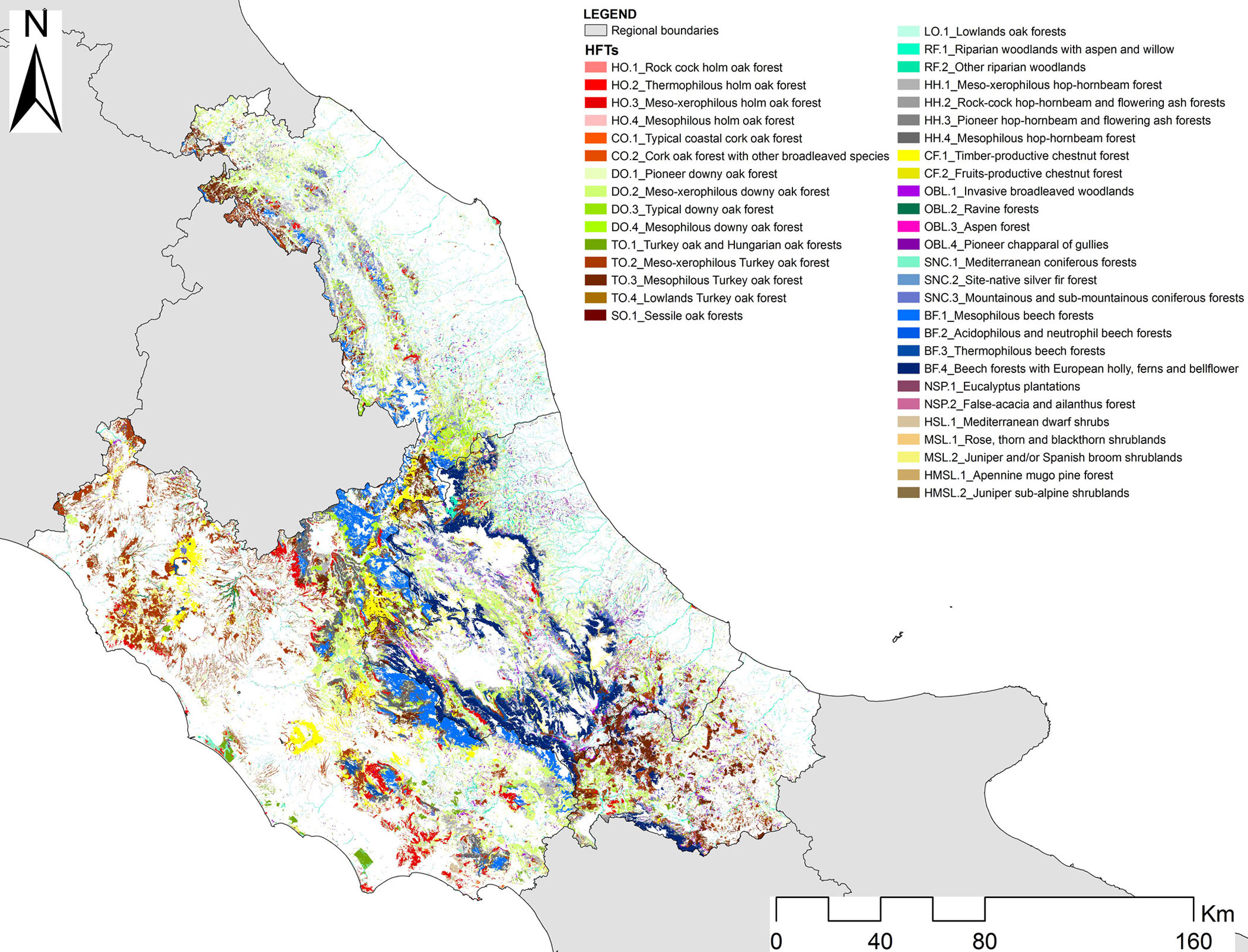
Merging the four FTs maps based on the new HFTNS in the study area we produced a new harmonized map (Fig. 2).
Fig. 2 - HFTs map of Central Italy. Thematic legend lists all HFTs as obtained through the harmonization process.
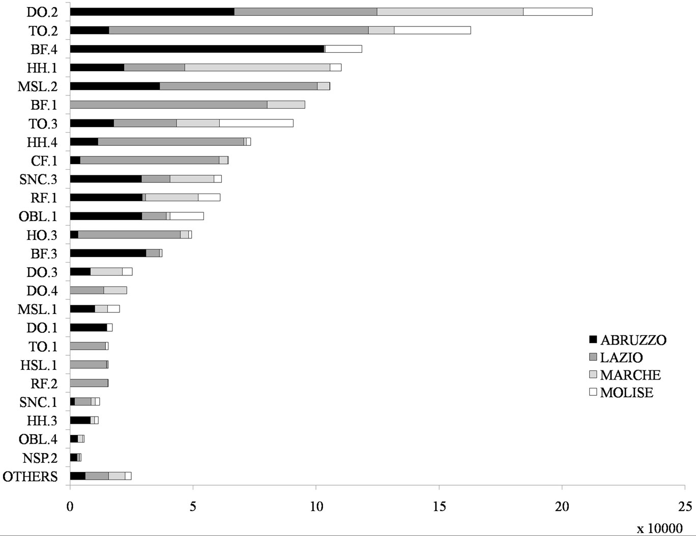
In Fig. 3 the area calculated on the basis of the dominant FCs was recalculated from the new harmonized map of Fig. 2.
Fig. 3 - HFTs area (ha) for each region in central Italy. See Appendix 1 for the HFTs label definition.
Results in terms of forest / non-forest area
The forest area in the study area was calculated on the basis of the five available datasets (Fig. 4).
Fig. 4 - Forest area estimates (ha) from HFCs map, CLC06 map, IUTI, INFC and JRC for all regions in central Italy. Error bars represent SE of IUTI and INFC, respectively.
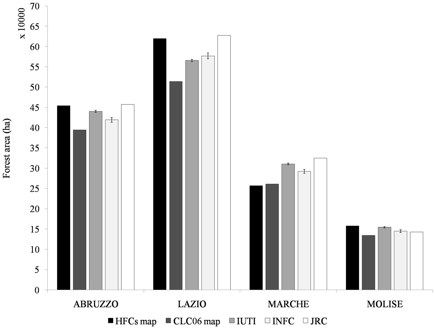
The design based forest area estimations by IUTI and INFC tends to be very similar (1 470 564 ha and 1 432 485 ha, respectively), the difference for both is within their relative confidence interval. The forest area from the HFCs and the JRC forest / non-forest maps appears to be higher (1 487 822 ha and 1 552 179 ha, respectively), while that from CLC06 appears lower (1 303 730 ha).
When the same comparison is carried out separately for the four administrative Regions (Fig. 4), the following main results can be denoted: (i) the sampling based estimations (IUTI and INFC) are never within their relative confidence intervals; (ii) in all Regions with the exception of Lazio, the INFC estimation is lower than that from IUTI; (iii) the forest area from CLC06 always tends to be lower with respect to IUTI and INFC; (iv) the forest area from the JRC forest / non-forest map always tends to be higher when compared to IUTI and INFC; (v) the forest area from HFCs maps tend to be higher than IUTI and INFC in all the Regions, with the exception of Marche; (vi) in Molise a relatively consistent agreement is shown across the different datasets.
Results in terms of forest types area
On the basis of the HFTs map (Fig. 2), the 37% of the total forest area is covered by forests dominated by Turkey and downy oaks (Quercus cerris and Q. pubescens), mainly in meso-xerophilous conditions, with a total of more than 547 000 ha. Beech forests (Fagus sylvatica), with 254 792 ha (about the 17% of the total), are the second most important HFC. They are mainly located in mountainous sites in Abruzzo and Molise. Other broadleaved forests in mesophylous conditions dominated by hop-hornbeam and flowering ash (Ostrya carpinifolia and Fraxinus ornus) cover almost 300 000 ha (13% of the total). Other FCs dominated by coniferous in mountainous (Pinus nigra and Abies alba) and Mediterranean conditions (Pinus pinea and Pinus pinaster), chestnut (Castanea sativa), evergreen oaks (Quercus ilex and Q. suber) and riparian formations, all range between 4 and 5%. Forest plantations are negligible and finally Other Wooded Land (OWL) covers almost 150 000 ha (10%).
To make possible the comparison of FCs across the three available sources (HFTs map, CLC06 map, and INFC statistics), we used an aggregated nomenclature system based on nine macro categories (Tab. 2).
Tab. 2 - Aggregated nomenclature system used to compare HFCs, INFC and CLC06. For each one of the nine aggregated classes the correspondence with the different sources is provided. See Appendix 2 for a more detailed description of the different classes.
| Aggregated HFCs |
HFCs | INFC | CLC06 Code (National level) | CLC06 Classes description |
|---|---|---|---|---|
| BF | BF | BF | 3.1.1.5 (3.1.3.1.5) |
Forests dominated by beech |
| CF | CF | CF | 3.1.1.4 (3.1.3.1.4) |
Forests dominated by chestnut |
| HO_CO | HO | HO | 3.1.1.1 (3.1.3.1.1) |
Forests dominated by oaks and other evergreen broadleaved species (holm oak and cork oak) |
| CO | CO | |||
| DO_SO_LO_TO | DO | DO_SO_LO | 3.1.1.2 (3.1.3.1.2) |
Forests dominated by other deciduous oaks (Turkey oak and/or downy oak and/or Hungarian oak and/or sessile oak) |
| SO | ||||
| LO | ||||
| TO | TO | |||
| HH_OBL | HH | HH | 3.1.1.3 (3.1.3.1.3) |
Forests dominated by other site-native broadleaves (mesophilous and meso-thermophilous broadleaves as maple-ash, hop-hornbeam and flowering ash) |
| OBL | OBL | |||
| RF | RF | RF | 3.1.1.6 (3.1.3.1.6) |
Forests dominated by hygrophytes |
| NSP | NSP | NSP | 3.1.1.7 | Forests and/or ex-plantations dominated by self-sown exotic broadleaved species |
| SNC | SNC.1 | SNC.1 | 3.1.2.1 (3.1.3.2.1) |
Forests dominated by Mediterranean pines and cypresses |
| SNC.2 | SNC.2 | 3.1.2.3 (3.1.3.2.3) |
Forests dominated by silver fir and/or spruce | |
| SNC.3 | SNC.3 | 3.1.2.2 (3.1.3.2.2) |
Forests dominated by oro-Mediterranean and Mountainous pines | |
| HSL_MSL_HMSL | HSL | HSL_MSL_HMSL | 3.2.2 3.2.3 3.2.4 |
Moorlands and bushes, sclerophyllous species areas, areas characterized by evolving woody and shrubby vegetation |
| MSL | ||||
| HMSL |
The results of the comparison are presented in Fig. 5. For only two classes, beech (BF) and deciduous oaks (DO_SO_LO_TO), the areas from both maps (HFCs and CLC06) were quite consistent with the official statistics from INFC but were outside of their confidence intervals. For both classes, the figures from the HFCs map were higher by 11% and 9% respectively, while the CLC06 figures for beech was higher by 7%, and lower for deciduous oaks by 6%. Together these two classes, on the basis of INFC, represent more than the 50% of the total forest and OWL area. In addition, three classes: chestnut (CF), evergreen oaks (HO_CO) and site native coniferous forests (SNC), showed a relatively consistent area estimation, but when combined based on the INFC, they only represent 12% of the total area. The figures from the HFCs map were higher than INFC by 53%, lower by 17% and higher by 31% respectively, while on the basis of CLC06 they were higher by 43%, and lower by 25% and by 2% respectively.
Fig. 5 - Forest area estimates (ha) from HFCs map, CLC06 map and INFC for each aggregated FC (see Appendix 1) and for each region in central Italy, separately. Error bars represent SE of INFC. See Appendix 1 for the HFCs label definition.
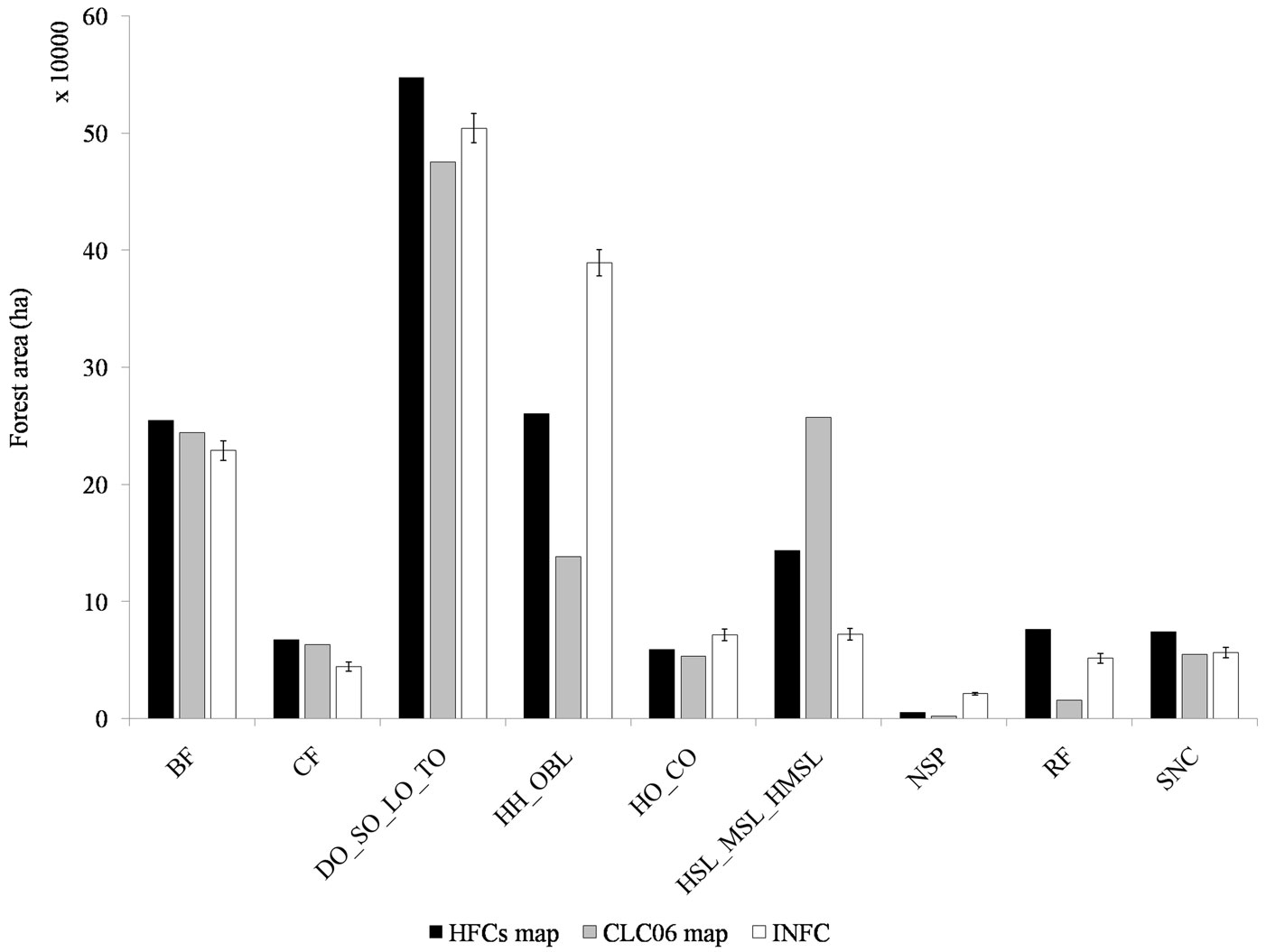
The remaining four classes show more relevant discrepancies. For other native broadleaved forests (HH-OBL), which represented 27% of the area, the HFCs and CLC06 figures were higher than INFC by 33% and 65%, respectively. For OWL (HSL_MSL_HMSL) (5% of the total) HFCs map was higher than INFC for the 99%, and the CLC06 was higher for a 257%, for riparian forests (RF) (3.5% of the total) the figure from HFCs map was higher than INFC for a 49% but that from CLC06 was lower for a 70% . Finally, for broadleaved plantations (NSP) (1.5% of the total) HFCs and CLC06 figures were lower than INFC for a 75% and for a 90% respectively.
Discussion and conclusions
This contribution presents the harmonization test carried out to merge high resolution FTs maps available for four administrative Regions in Central Italy. The maps were independently developed referring to the period 2001-2007 and adopted the same FAO forest definition, and were created with the same methodology.
Following the approach proposed by Ståhl et al. ([32]), harmonization bridges in the form of univocal correspondences among different FTs nomenclature systems, were used to develop a reference harmonized FTs nomenclature system (HFTNS) and bridges were then created between the HFTNS and the original FTs. After the harmonization, the forest area calculated on the basis of the different data sources (inventories and maps) was compared.
The proposed bottom-up approach appears to be feasible to classify and harmonize forest resources. Indeed, it guarantees the integrity and homogeneity of local FTs systems, as well as the best possible characterization of forest resources at regional level, maintaining the possibility of upscaling and downscaling information at the different spatial scales.
The HFTNS was aimed at solving current difficulties in exchanging forest data and information between forest managers, land planners and decision-makers at different scales and across different local administrations. For example, on the basis of the HFTs map, the automatic derivation of a FTs map for those protected areas which are across the regional administrative borders is now possible. Harmonized nomenclature systems should be used for multi-scale forest resources monitoring to limit lacks and mismatches in available data and information, also contributing to reduce the delay in the implementation of common rules, laws and guidelines at regional, national, and European levels.
Even if the methodology was successfully applied in the case study presented, some critical points in harmonizing FTs need to be highlighted. It is possible to create bridges between different FTs systems but it is more difficult to find correspondences between forest classification systems developed using different approaches. This was the case when we compared local FTs systems with the forest classes used by the INFC, which are not based on the “forest type” approach but are more simply based on dominant tree species. On the opposite, the identification of bridges between the four local FTs systems and the EFTs system developed by EEA was quite straightforward ([3]).
In Italy, the “forest type” definition is based on a mix of physiognomic-structural characteristics and syntaxonomic and floristic information of the current stand conditions. Unlike phytosociological approach, the FTs approach is not based on the concept of climax or potential vegetation. Indeed, FTs represent only the actual forest vegetation resulting from the spatial and temporal scales and patterns of disturbances. Nonetheless, in most cases the correspondences are possible between the two approaches (FTs vs. phytosociological systems). This was clearly demonstrated in our test case with the quite simple and direct relationship we found between local FTs and the botanical approach used by Blasi ([4] - see Appendix 3 for the results).
The results obtained in forest area estimation by forest macro-categories (Fig. 5) indicate a general mismatch between the results from the different FCs maps (from HFCs and CLC06) when compared with INFC estimates. The agreement is higher for the two dominant FCs (deciduous oaks and beech), but the error is never below the 6%, always more than the confidence interval of INFC.
When these results are analyzed separately for each Region (Fig. 5), we found that the Molise is the region where the area figures calculated for five out of the nine macro categories from the HFCs map (BF, HH-OBL, NSP, RF and SNC) are within the confidence intervals of INFC estimates. This result is obtained only in Abruzzo with CF and SNC and in Lazio and Marche with HO-CO and SNC. These results can probably be explained considering that forest types dominated by deciduous oaks (mainly Quercus cerris and Q. pubescens) have frequently the presence of Acer and Fraxinus spp. too. Using photointerpretation, it is extremely difficult to discriminate these mesophylous formations and consequently obtain a good accuracy in mapping HH-OBL classes. The same problem probably occurred in mapping OWL (the HSL_MSL_HMSL macro category). We hope that the future availability of wall-to-wall Airborne Laser Scanning (ALS) data would contribute to a better discrimination of these formations on the basis of their canopy height.
When moving from FCs to forest / non-forest area estimation, the divergences between the different sources of information, including the pan-European mapping approaches, are reduced.
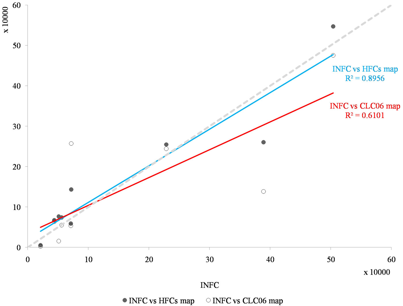
It is important to note that the agreement with INFC estimates is higher for HFCs maps than for CLC06 (Fig. 6). This is an expected result since all the FTs maps available in the four Regions are implemented with a MMU and a minimum crown coverage that is coincident with the forest definition adopted by the INFC, while the CLC06 is implemented with a much greater MMU (25 ha for a reference scale of 1:100 000) and a crown cover threshold of 30% instead of 10%. These results confirm previous conclusions related to the fact that the forest area calculated on the basis of CLC is usually underestimated when compared with national forest inventories estimates ([31]).
Fig. 6 - Comparison of HFCs and CLC06 forest area estimation against INFC, values in 104 ha. Each case is one of the aggregated forest macro-categories from Tab. 2 for each of the four Regions. Linear regression for CLC06 has R2 of 0.61 and of 0.89 for HFCs.
Local differences in the investigated Regions are probably due to the quality of the different maps, a more in deep analysis of omission and commission errors could be possible only if the location of INFC sampling units would be available.
In the future we hope that the different forest monitoring and forest inventory programs currently active in Italy, as well as in Europe, will potentially converge on a common nomenclature system. The raw data acquired in forest inventories can be used to obtain forest area estimates on the basis of multiple nomenclature systems. Stakeholders and agencies responsible for forest inventories and land use/land cover mapping should join the efforts at national and local level in order to develop harmonized multiscale systems. The EFTs ([3]) appear as a good basis to create a practical relationship between local forest management and country and European programs. The links we proposed between HFCs vegetation classes and CORINE biotopes (Appendix 3) could be extremely useful for forest managers involved in activities related to the application of SFM practices, for example within Natura2000 Network sites.
An attempt to establish bridging functions between HFCs and Natura2000 Network would be very interesting to highlight the implications of forest type mapping as well as for mapping Natura2000 Network habitats.
Recently for the first time Forest Europe/UNECE/FAO ([19]) presented forest area estimates based on the EFTs nomenclature system ([3]); but at the moment a pan-European FTs map still does not exist, even considering that several tests were carried out to obtain a coniferous/ broadleaved map ([25]) and a dominant tree species map ([5]).
Several possible and feasible solutions can be foreseen to derive a EFTs (sensu [3]) map, if a new parallel project will not be funded: upgrading the Corine Land Cover including a more detailed FCs classification, following the example of Italy, or harmonizing and then merging local and national forest maps available in the different Countries, or using the plot level information from NFIs, or a mix of the aforementioned approaches.
Acknowledgements
We would like to thank the colleagues at the Dipartimento di Bioscienze e Territorio of the University of Molise, for their support in data elaboration and analysis: Carmen Giancola, Daniela Tonti, Giovanni Santopuoli, Michele Minotti, Bruno Lasserre and Lorenzo Sallustio. We also thank Prof. Carlo Urbinati and Dr. Francesco Renzaglia from the Università Politecnica delle Marche for their support and help to analyze the FTs map of Marche region.
A special thanks to the anonymous reviewers who helped us in ameliorating a previous version of this manuscript, and to Daniel O. McInerney at Coillte (IR) for word revising and English check.
Finally, we thank Abruzzo, Lazio and Molise regional administrations for making available the FTs maps.
This work was partially carried out within the framework contract “Forests: fifth specific contract” between the European Environmental Agency, the European Forest Institute and the Italian Academy of Forest Sciences (contract no. EEA/NSV/10/004) and partially within the project “Development of innovative methods for forest ecosystems monitoring based on remote sensing”, funded by the Italian Ministry of University and Research (PRIN 2012, grant no. 2012EWEY 2S, national scientific coordinator Prof. G. Chirici).
References
Gscholar
Gscholar
Gscholar
Gscholar
CrossRef | Gscholar
Gscholar
Gscholar
Gscholar
Gscholar
Gscholar
Gscholar
Gscholar
Gscholar
Gscholar
Gscholar
Gscholar
Gscholar
Gscholar
Gscholar
Gscholar
Gscholar
Gscholar
Gscholar
Gscholar
Gscholar
Supplementary Material
Authors’ Info
Authors’ Affiliation
Gherardo Chirici
Vittorio Garfì
Marco Marchetti
Dipartimento di Bioscienze e Territorio (DiBT), Università degli Studi del Molise, Contrada Fonte Lappone, I-86090 Pesche, Isernia (Italy)
Consiglio per la ricerca e la sperimentazione in Agricoltura, Forestry Research Centre, v.le S. Margherita 80, I-52100 Arezzo (Italy)
European Environmental Agency, Kongens Nytorv 6, DK-1050 Copenhagen (Denmark)
Corresponding author
Paper Info
Citation
Vizzarri M, Chiavetta U, Chirici G, Garfì V, Bastrup-Birk A, Marchetti M (2015). Comparing multisource harmonized forest types mapping: a case study from central Italy. iForest 8: 59-66. - doi: 10.3832/ifor1133-007
Academic Editor
Luca Salvati
Paper history
Received: Sep 20, 2013
Accepted: Feb 26, 2014
First online: Jun 17, 2014
Publication Date: Feb 02, 2015
Publication Time: 3.70 months
Copyright Information
© SISEF - The Italian Society of Silviculture and Forest Ecology 2015
Open Access
This article is distributed under the terms of the Creative Commons Attribution-Non Commercial 4.0 International (https://creativecommons.org/licenses/by-nc/4.0/), which permits unrestricted use, distribution, and reproduction in any medium, provided you give appropriate credit to the original author(s) and the source, provide a link to the Creative Commons license, and indicate if changes were made.

Web Metrics
Breakdown by View Type
Article Usage
Total Article Views: 62792
(from publication date up to now)
Breakdown by View Type
HTML Page Views: 50386
Abstract Page Views: 3766
PDF Downloads: 6953
Citation/Reference Downloads: 36
XML Downloads: 1651
Web Metrics
Days since publication: 4379
Overall contacts: 62792
Avg. contacts per week: 100.38
Article Citations
Article citations are based on data periodically collected from the Clarivate Web of Science web site
(last update: Mar 2025)
Total number of cites (since 2015): 15
Average cites per year: 1.36
Publication Metrics
by Dimensions ©
Articles citing this article
List of the papers citing this article based on CrossRef Cited-by.
Related Contents
iForest Similar Articles
Review Papers
Integration of forest mapping and inventory to support forest management
vol. 3, pp. 59-64 (online: 17 May 2010)
Research Articles
Experimenting the design-based k-NN approach for mapping and estimation under forest management planning
vol. 5, pp. 26-30 (online: 27 February 2012)
Research Articles
Networking sampling of Araucaria araucana (Mol.) K. Koch in Chile and the bordering zone of Argentina: implications for the genetic resources and the sustainable management
vol. 2, pp. 207-212 (online: 22 December 2009)
Research Articles
Are we ready for a National Forest Information System? State of the art of forest maps and airborne laser scanning data availability in Italy
vol. 14, pp. 144-154 (online: 23 March 2021)
Technical Reports
Conservation and use of elm genetic resources in France: results and perspectives
vol. 13, pp. 41-47 (online: 03 February 2020)
Research Articles
Comparing land use registry and sample based inventory to estimate forest area in Podlaskie, Poland
vol. 10, pp. 315-321 (online: 23 February 2017)
Research Articles
Integrating area-based and individual tree detection approaches for estimating tree volume in plantation inventory using aerial image and airborne laser scanning data
vol. 10, pp. 296-302 (online: 15 December 2016)
Technical Advances
Improved estimates of per-plot basal area from angle count inventories
vol. 7, pp. 178-185 (online: 17 February 2014)
Research Articles
Allometric models for the estimation of foliage area and biomass from stem metrics in black locust
vol. 15, pp. 281-288 (online: 27 July 2022)
Research Articles
Harmonized dataset of surface fuels under Alpine, temperate and Mediterranean conditions in Italy. A synthesis supporting fire management
vol. 13, pp. 513-522 (online: 13 November 2020)
iForest Database Search
Google Scholar Search
Citing Articles
Search By Author
Search By Keywords


