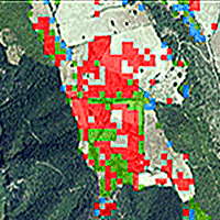
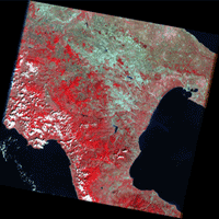
The evaluation of natural forest expansion is a crucial issue for understanding fundamental processes related to climate change and carbon uptake. The identification of forest expansion/reduction dynamics at a regional scale has been provided through multitemporal analyses of high-resolution satellite images. This study aims to compare different Change Detection (CD) techniques to assess forest expansion in the Basilicata region (Southern Italy). Landsat 5 TM image from 2003 and Landsat 8 OLI image from 2019 were used for this purpose. The CD methods implemented were NDVI Differencing and Post-Classification Comparison (PCC). Using a confusion matrix, PCC showed better performance than NDVI Differencing (Overall Accuracy of 0.85 and 0.62, respectively). The comparison of the evaluated forest expansion areas with inventory data shows the good performance of CD procedures in assessing forest land use changes. The use of satellite images and Change Detection techniques can be applied where a high temporality and a wide geographical extension are required, conditions in which traditional procedures involving field surveys are too expensive in terms of time and money. Furthermore, the use of satellite images allows for the detection of changes in the Earth’s surface in particularly inaccessible areas of the globe.
Keywords
, , , , , , , ,
Citation
Mancino G, Falciano A, Trivigno ML (2025). Change Detection methods for forest expansion assessment in the last twenty years in the Mediterranean Basin. iForest 18: 69-78. - doi: 10.3832/ifor4634-018
Academic Editor
Carlotta Ferrara
Paper history
Received: May 03, 2024
Accepted: Feb 03, 2025
First online: Apr 16, 2025
Publication Date: Apr 30, 2025
Publication Time: 2.40 months
© SISEF - The Italian Society of Silviculture and Forest Ecology 2025
Open Access
This article is distributed under the terms of the Creative Commons Attribution-Non Commercial 4.0 International (https://creativecommons.org/licenses/by-nc/4.0/), which permits unrestricted use, distribution, and reproduction in any medium, provided you give appropriate credit to the original author(s) and the source, provide a link to the Creative Commons license, and indicate if changes were made.

Breakdown by View Type
(Waiting for server response...)
Article Usage
Total Article Views: 9955
(from publication date up to now)
Breakdown by View Type
HTML Page Views: 5230
Abstract Page Views: 2060
PDF Downloads: 2388
Citation/Reference Downloads: 4
XML Downloads: 273
Web Metrics
Days since publication: 437
Overall contacts: 9955
Avg. contacts per week: 159.46
Article Citations
Article citations are based on data periodically collected from the Clarivate Web of Science web site
(last update: Mar 2025)
(No citations were found up to date. Please come back later)
Publication Metrics
by Dimensions ©
Articles citing this article
List of the papers citing this article based on CrossRef Cited-by.
(1)
Afify HA (2011)Evaluation of change detection techniques for monitoring land-cover changes: A case study in new Burg El-Arab area. Alexandria Engineering Journal 50: 187-195.
CrossRef |
Gscholar
(2)
Atkins JW, Epstein HE, Welsch DL (2018)Using Landsat imagery to map understory shrub expansion relative to landscape position in a mid-Appalachian watershed. Ecosphere 9: e02404.
CrossRef |
Gscholar
(3)
Ayanz M, Jomaa I, Kheir R (2013)Multitemporal unsupervised classification and NDVI to monitor land cover change in Lebanon (1987-1998). SematicScolar, artID 56082163.
Online |
Gscholar
(4)
Bastin J-F, Finegold Y, Garcia C, Mollicone D, Rezende M, Routh D, Zohner CM, Crowther TW (2019)The global tree restoration potential. Science 365: 76-79.
CrossRef |
Gscholar
(5)
Berberoglu S, Akin A (2009)Assessing different remote sensing techniques to detect land use/cover changes in the eastern Mediterranean. International Journal of Applied Earth Observation and Geoinformation 11: 46-53.
CrossRef |
Gscholar
(6)
Bourgeau-Chavez LL, Kasischke ES, Brunzell S, Mudd JP, Tukman M (2002)Mapping fire scars in global boreal forests using imaging radar data. International Journal of Remote Sensing 23: 4211-4234.
CrossRef |
Gscholar
(7)
Bovolo F, Bruzzone L, Marconcini M (2008)A novel approach to unsupervised change detection based on a semisupervised SVM and a similarity measure. IEEE Transactions on Geoscience and Remote Sensing 46: 2070-2082.
CrossRef |
Gscholar
(8)
Chen G, Hay GJ, Carvalho LMT, Wulder MA (2012)Object-based change detection. International Journal of Remote Sensing 33: 4434-4457.
CrossRef |
Gscholar
(9)
Cohen J (1960)A coefficient of agreement for nominal scales. Educational and Psychological Measurement 20: 37-46.
CrossRef |
Gscholar
(10)
Cohen WB, Spies TA, Alig RJ, Oetter DR, Maiersperger TK, Fiorella M (2002)Characterizing 23 years (1972-95) of stand replacement disturbance in western Oregon forests with Landsat imagery. Ecosystems 5: 122-137.
CrossRef |
Gscholar
(11)
Collins JB, Woodcock CE (1996)An assessment of several linear change detection techniques for mapping forest mortality using multitemporal Landsat TM data. Remote Sensing of Environment 56: 66-77.
CrossRef |
Gscholar
(12)
Coppin P, Jonckheere I, Nackaerts K, Muys B, Lambin E (2004)Digital change detection methods in ecosystem monitoring: a review. International Journal of Remote Sensing 25: 1565-1596.
CrossRef |
Gscholar
(13)
Cruz-Alonso V, Ruiz-Benito P, Villar-Salvador P, Rey-Benayas JM (2019)Long-term recovery of multifunctionality in Mediterranean forests depends on restoration strategy and forest type. Journal of Applied Ecology 56: 745-757.
CrossRef |
Gscholar
(14)
De Beurs KM, Henebry GM (2005)A statistical framework for the analysis of long image time series. International Journal of Remote Sensing 26: 1551-1573.
CrossRef |
Gscholar
(15)
Desclée B, Bogaert P, Defourny P (2006)Forest change detection by statistical object-based method. Remote Sensing of Environment 102: 1-11.
CrossRef |
Gscholar
(16)
FAO (2020)Global forest resources assessment 2020: main report. FAO, Rome, Italy, pp. 184.
CrossRef |
Gscholar
(17)
Fatemi Nasrabadi SB (2019)Questions of concern in drawing up a remote sensing change detection plan. Journal of the Indian Society of Remote Sensing 47: 1455-1469.
CrossRef |
Gscholar
(18)
Fazal S (2000)Urban expansion and loss of agricultural land - a GIS-based study of Saharanpur City, India. Environment and Urbanization 12: 133-149.
CrossRef |
Gscholar
(19)
Galidaki G, Zianis D, Gitas I, Radoglou K, Karathanassi V, Tsakiri-Strati M, Woodhouse I, Mallinis G (2017)Vegetation biomass estimation with remote sensing: focus on forest and other wooded land over the Mediterranean ecosystem. International Journal of Remote Sensing 38: 1940-1966.
CrossRef |
Gscholar
(20)
Gasparini P, Tabacchi G (2022)Changes of Italian forests over time captured by the national forest inventories. In: “Italian National Forest Inventory Methods and Results of the Third Survey: Inventario Nazionale delle Foreste e dei Serbatoi Forestali di Carbonio Metodi e Risultati della Terza Indagine” (Gasparini P, Di Cosmo L, Floris A, De D L eds). Springer International Publishing, Cham, Switzerland, pp. 545-568.
CrossRef |
Gscholar
(21)
Ge J, Zhang ZJ, Lin B (2023)Towards carbon neutrality: how much do forest carbon sinks cost in China? Environmental Impact Assessment Review. 98: 106949.
CrossRef |
Gscholar
(22)
Gudex-Cross D, Pontius J, Adams A (2017)Enhanced forest cover mapping using spectral unmixing and object-based classification of multi-temporal Landsat imagery. Remote Sensing of Environment 196: 193-204.
CrossRef |
Gscholar
(23)
Häme T, Heiler I, San Miguel-Ayanz J (1998)An unsupervised change detection and recognition system for forestry. International Journal of Remote Sensing 19: 1079-1099.
CrossRef |
Gscholar
(24)
Hansen MC, Potapov PV, Moore R, Hancher M, Turubanova SA, Tyukavina A, Thau D, Stehman SV, Goetz SJ, Loveland TR, Kommareddy A, Egorov A, Chini L, Justice CO, Townshend JRG (2013)High-resolution global maps of 21st-century forest cover change. Science 342: 850-853.
CrossRef |
Gscholar
(25)
Hargrove WW, Spruce JP, Gasser GE, Hoffman FM (2009)Toward a national early warning system for forest disturbances using remotely sensed canopy phenology. Photogrammetric Engineering and Remote Sensing 75: 1150-1156.
Online |
Gscholar
(26)
Hermosilla T, Wulder MA, White JC, Coops NC, Hobart GW (2015)An integrated Landsat time series protocol for change detection and generation of annual gap-free surface reflectance composites. Remote Sensing of Environment 158: 220-234.
CrossRef |
Gscholar
(27)
Höchtl F, Lehringer S, Konold W (2005)“Wilderness”: what it means when it becomes a reality a case study from the southwestern Alps. Landscape and Urban Planning 70: 85-95.
CrossRef |
Gscholar
(28)
Irons JR, Dwyer JL, Barsi JA (2012)The next Landsat satellite: the Landsat data continuity mission. Remote Sensing of Environment 122: 11-21.
CrossRef |
Gscholar
(29)
Jensen J (2015)Introductory digital image processing: a remote sensing perspective (4th edn). Pearson, Glenview, IL, USA, pp. 656.
Gscholar
(30)
Lambin EF, Geist HJ, Lepers E (2003)Dynamics of land-use and land-cover change in tropical regions. Annual Review of Environment and Resources 28: 205-241.
CrossRef |
Gscholar
(31)
Li H, Li Y, Gao Y, Zou C, Yan S, Gao J (2016)Human impact on vegetation dynamics around Lhasa, southern Tibetan Plateau, China. Sustainability 8: 1146.
CrossRef |
Gscholar
(32)
Li S, Ganguly S, Dungan JL, Wang W, Nemani RR (2017)Sentinel-2 MSI radiometric characterization and cross-calibration with Landsat-8 OLI. Advances in Remote Sensing 6: 147-159.
CrossRef |
Gscholar
(33)
Lu D, Hetrick S, Moran E, Li G (2012)Application of time series Landsat images to examining land-use/land-cover dynamic change. Photogrammetric Engineering and Remote Sensing 78: 747-755.
Online |
Gscholar
(34)
Lu D, Li G, Moran E, Kuang W (2014)A comparative analysis of approaches for successional vegetation classification in the Brazilian Amazon. GIScience and Remote Sensing 51: 695-709.
CrossRef |
Gscholar
(35)
Lu D, Mausel P, Brondízio E, Moran E (2004)Change detection techniques. International Journal of Remote Sensing 25: 2365-2401.
CrossRef |
Gscholar
(36)
Lugo E (2008)Ecosystem services, the millennium ecosystem assessment, and the conceptual difference between benefits provided by ecosystems and benefits provided by people. Journal of Land Use and Environmental Law 23: 243-261.
Gscholar
(37)
Lunetta RS, Elvidge C (1999)Remote sensing change detection: environmental monitoring methods and applications. Taylor and Francis, London, UK, pp. 318. -
Online |
Gscholar
(38)
Lyon J, Yuan D, Lunetta R, Elvidge C (1998)A change detection experiment using vegetation indices. Photogrammetric Engineering and Remote Sensing 64: 143-150.
Gscholar
(39)
Mancino G, Nolè A, Ripullone F, Ferrara A (2014)Landsat TM imagery and NDVI differencing to detect vegetation change: assessing natural forest expansion in Basilicata, southern Italy. iForest - Biogeosciences and Forestry 7: 75-84.
CrossRef |
Gscholar
(40)
Mancino G, Falciano A, Console R, Trivigno ML (2023)Comparison between parametric and non-parametric supervised land cover classifications of Sentinel-2 MSI and Landsat-8 OLI Data. Geographies 3: 82-109.
CrossRef |
Gscholar
(41)
Márquez-Romance AM, Farías-De Márquez BE, Guevara-Pérez E (2022)Land use and land cover change detection using satellite remote sensing techniques in a tropical basin. Environmental Quality Management 31: 183-196.
CrossRef |
Gscholar
(42)
Mas J-F (1999)Monitoring land-cover changes: a comparison of change detection techniques. International Journal of Remote Sensing 20: 139-152.
CrossRef |
Gscholar
(43)
Mas J-F, Soares Filho B, Pontius R, Farfán Gutiérrez M, Rodrigues H (2013)A suite of tools for ROC analysis of spatial models. ISPRS International Journal of Geo-Information 2: 869-887.
CrossRef |
Gscholar
(44)
Matos FAR, Magnago LFS, Aquila Chan Miranda C, De Menezes LFT, Gastauer M, Safar NVH, Schaefer CEGR, Da Silva MP, Simonelli M, Edwards FA, Martins SV, Meira-Neto JAA, Edwards DP (2020)Secondary forest fragments offer important carbon and biodiversity cobenefits. Global Change Biology 26: 509-522.
CrossRef |
Gscholar
(45)
Morisette J, Khorram S (2000)Accuracy assessment curves for satellite-based change detection. Photogrammetric Engineering and Remote Sensing 66: 875-880.
Gscholar
(46)
Nurda N, Noguchi R, Ahamed T (2020)Change detection and land suitability analysis for extension of potential forest areas in Indonesia using satellite remote sensing and GIS. Forests 11: 398.
CrossRef |
Gscholar
(47)
Othman A, Al-Saady Y, Obaid A, Gloaguen R (2012)Environmental change detection in the central part of Iraq using remote sensing data and GIS. Arabian Journal of Geosciences 7: 1017-1028.
CrossRef |
Gscholar
(48)
Ozturk T, Ceber ZP, TürkeA, Kurnaz ML (2015)Projections of climate change in the Mediterranean Basin by using downscaled global climate model outputs. International Journal of Climatology 35: 4276-4292.
CrossRef |
Gscholar
(49)
Peng D, Zhang Y (2017)Object-based change detection from satellite imagery by segmentation optimization and multi-features fusion. International Journal of Remote Sensing 38: 3886-3905.
CrossRef |
Gscholar
(50)
Peng J, Wu J, Yin H, Li Z, Chang Q, Mu T (2008)Rural land use change from 1986 to 2002 in Lijiang, China, based on remote sensing and GIS data. Sensors 8: 8201-8223.
CrossRef |
Gscholar
(51)
Petit C, Scudder T, Lambin E (2001)Quantifying processes of land-cover change by remote sensing: resettlement and rapid land-cover changes in south-eastern Zambia. International Journal of Remote Sensing 22: 3435-3456.
CrossRef |
Gscholar
(52)
Piussi P, Pettenella D (2000)Spontaneous afforestation of fallows in Italy. In: Proceedings of the Symposium “NEWFOR - New Forests for Europe: Afforestation at the Turn of the Century” (Weber N, European Forest Institute eds). Freiburg (Germany) 16-17 Feb 2000. European Forest Institute, Joensuu, Finland, pp. 248.
Gscholar
(53)
Pu R, Gong P, Tian Y, Miao X, Carruthers RI, Anderson GL (2008)Invasive species change detection using artificial neural networks and CASI hyperspectral imagery. Environmental Monitoring and Assessment 140: 15-32.
CrossRef |
Gscholar
(54)
Pugh TAM, Lindeskog M, Smith B, Poulter B, Arneth A, Haverd V, Calle L (2019)Role of forest regrowth in global carbon sink dynamics. Proceedings of the National Academy of Sciences USA 116: 4382-4387.
CrossRef |
Gscholar
(55)
Rogan J, Miller J (2006)Integrating GIS and remotely sensed data for mapping forest disturbance and change. In: “Understanding Forest Disturbance and Spatial Pattern” (Wulder MA, MA, Franklin SE eds). CRC Press, Boca Raton, FL, USA, pp. 133-171.
CrossRef |
Gscholar
(56)
Salvati L, Ranalli F, Gitas I (2014)Landscape fragmentation and the agro-forest ecosystem along a rural-to-urban gradient: an exploratory study. International Journal of Sustainable Development and World Ecology 21: 160-167.
CrossRef |
Gscholar
(57)
Sarti M, Vaccari FP, Calfapietra C, Brugnoli E, Scartazza A (2020)A statistical approach to detect land cover changes in Mediterranean ecosystems using multi-temporal Landsat data: the case study of Pianosa Island, Italy. Forests 11: 334.
CrossRef |
Gscholar
(58)
Schroeder TA, Cohen WB, Song C, Canty MJ, Yang Z (2006)Radiometric correction of multi-temporal Landsat data for characterization of early successional forest patterns in western Oregon. Remote Sensing of Environment 103: 16-26.
CrossRef |
Gscholar
(59)
Singh A (1989)Digital change detection techniques using remotely-sensed data. International Journal of Remote Sensing 10: 989-1003.
CrossRef |
Gscholar
(60)
Song C, Woodcock CE (2003)Monitoring forest succession with multitemporal Landsat images: factors of uncertainty. IEEE Transactions on Geoscience and Remote Sensing 41: 2557-2567.
CrossRef |
Gscholar
(61)
Song C, Woodcock CE, Seto KC, Lenney MP, Macomber SA (2001)Classification and change detection using Landsat TM data: when and how to correct atmospheric effects? Remote Sensing of Environment 75: 230-244.
CrossRef |
Gscholar
(62)
Song X-P, Hansen MC, Stehman SV, Potapov PV, Tyukavina A, Vermote EF, Townshend JR (2018)Global land change from 1982 to 2016. Nature 560: 639-643.
CrossRef |
Gscholar
(63)
Suárez-Seoane S, Osborne PE, Baudry J (2002)Responses of birds of different biogeographic origins and habitat requirements to agricultural land abandonment in northern Spain. Biological Conservation 105: 333-344.
CrossRef |
Gscholar
(64)
Usman M, Liedl R, Shahid MA, Abbas A (2015)Land use/land cover classification and its change detection using multi-temporal MODIS NDVI data. Journal of Geographical Sciences 25: 1479-1506.
CrossRef |
Gscholar
(65)
Wang B, Jia K, Liang S, Xie X, Wei X, Zhao X, Yao Y, Zhang X (2018)Assessment of Sentinel-2 MSI spectral band reflectances for estimating fractional vegetation cover. Remote Sensing 10: 1927.
CrossRef |
Gscholar
(66)
Wang W, Hall-Beyer M, Wu C, Fang W, Nsengiyumva W (2019)Uncertainty problems in image change detection. Sustainability 12: 274.
CrossRef |
Gscholar
(67)
Weber K (2001)A method to incorporate phenology into land cover change analysis. Journal of Range Management 54: A1-A7.
Online |
Gscholar
(68)
Xiaolong D, Khorram S (1998)The effects of image misregistration on the accuracy of remotely sensed change detection. IEEE Transactions on Geoscience and Remote Sensing 36: 1566-1577.
CrossRef |
Gscholar
(69)
Xue L, Kappas M, Wyss D, Wang C, Putzenlechner B, Thi NP, Chen J (2022)Assessment of climate change and human activities on vegetation development in northeast China. Sensors 22: 2509.
CrossRef |
Gscholar
(70)
Yan J, He H, Wang L, Zhang H, Liang D, Zhang J (2022)Inter-comparison of four models for detecting forest fire disturbance from MOD13A2 time series. Remote Sensing 14: 1446.
CrossRef |
Gscholar
(71)
Yang X, Lo CP (2000)Relative radiometric normalization performance for change detection from multi-date satellite images. Photogrammetric Engineering and Remote Sensing 66: 967-980.
Gscholar
(72)
Yuan D, Eldvige CD, Lunetta RS (1999)Survey of multispectral methods for land cover change analysis. In: “Remote Sensing Change Detection: Environmental Monitoring Methods and Applications” (RS Lunetta, C Elvidge eds). Taylor and Francis, London, UK, pp. 318.
Gscholar
(73)
Zhu Z (2017)Change detection using landsat time series: a review of frequencies, preprocessing, algorithms, and applications. ISPRS Journal of Photogrammetry and Remote Sensing 130: 370-384.
CrossRef |
Gscholar