A primary evaluation of Syrian forest damage since 2011: a case study of Alhamam and Alboz forest sites
iForest - Biogeosciences and Forestry, Volume 16, Issue 3, Pages 144-154 (2023)
doi: https://doi.org/10.3832/ifor4032-016
Published: May 30, 2023 - Copyright © 2023 SISEF
Research Articles
Abstract
Forests and trees make vital contributions to well-being, economic activities, ecosystem functioning and global system dynamics. There has been a lack of studies on the evaluation of the drivers of Syrian forest damage during the current conflict. This study estimated the damage since 2011 in the Alhamam and Alboz forest sites in Idlib province of Syria and evaluated the drivers of this damage. A multidimensional approach to damage assessment was developed which combined forest plot inventories, remotely sensed satellite image analysis, questionnaires and focus groups to enable a comparison of the forest from 2011 and 2017. The plot inventory data and remote sensing analysis provided estimates of forest damage and loss whilst focus groups and questionnaires provided vital information on the drivers of forest loss which is required for developing reforestation programmes. Overall, forest inventory data and satellite image analysis results indicated a reduction in tree cover, density and plant diversity. The results indicate a much higher loss of forest than is available from global products such as Global Forest Watch due to the prevalence in Syria of low-density Oak forests such as Alhamam not being classed as forest. The results of questionnaires and focus groups showed that the main cause of damage was an increased demand for fire-wood driven by a lack of fuel oil and increased unemployment, reduced household incomes and general price rises, making fuel more unaffordable. Respondents to surveys generally understood the importance of trees and forests and overtime the local knowledge of the importance of forest resources had not changed. This multidimensional approach indicates a reduced capacity of institutions to protect forests and will help to establish strategic plans to serve and protect the forest in the future.
Keywords
Introduction
Forests make vital contributions to the existence of both people and plants, bolstering livelihoods, providing clean air and water, conserving and supporting biodiversity and responding to climate change ([14]). Forests provide important ecological services, including storing carbon, buffering against floods and drought, stabilizing soils, influencing rainfall patterns and providing a home to wildlife and indigenous people. Forests are also a source of many useful products upon which local communities depend. Forests are crucial to humanity, yet they are rapidly being destroyed by human activities. The biggest cause of deforestation is conversion of forest land for agriculture ([4]). In the past, subsistence agriculture was the primary driver of rainforest conversion, but today industrial agriculture (especially monoculture and livestock production) is the dominant driver of rainforest loss worldwide ([4]). Forest degradation is also a serious problem and logging is the biggest cause of degradation and usually precedes deforestation for agriculture. This has led to several studies that have been conducted on the assessment of forest damage ([47], [34]). In this study we examine forest loss and forest degradation in two forests of Idleb, Syria between 2011 and 2017. We use a triangulation approach to estimate the extent of forest loss and damage, compare that to the Global Forest Watch (GFW) products and establish likely drivers of the loss and damage.
Climate change affects natural resources, especially water and soil ([28]). During the past fifty years, there have been changes in rainfall patterns in Syria, in addition to noticeable fluctuations in minimum and upper temperatures ([46]). There are contested arguments over the causes/driving factors for the conflict in Syria. Kelley et al. ([23]) claim that evidence suggests the 2007-2010 drought contributed to the conflict in Syria. The drought crises leading up to 2011 were among the most severe, affecting food security in Syria, as it witnessed successive periods of drought ([22]). For example, groundwater levels have dropped, partly due to human extraction but also the regular drought periods experienced in Syria. This has caused the flow of some waterways to decrease significantly which will have subsequent impacts on groundwater levels. For example, the Khabour River in Hasaka Governorate has seen its flow decrease from 40 cubic meters per second in 1980 to 14 in 1998 and 7.4 cubic metres per second in 2003. However, drought may have caused rural-urban migration within Syria but evidence for drought being a main contributor to the outbreak of the civil war is lacking ([12], [44]).
The impact of conflict on deforestation
Most studies that examine the impact of conflict on forest resources find a complex set of changes during and after the conflict for a variety of reasons. Overall, conflict and war has a negative impact on conservation and protection of biodiversity and pollution control at local and global levels ([38]). War and military actions can significantly affect the structure and function of ecosystems through population and biodiversity losses ([25]). Several previous studies investigated the impact of conflicts on biodiversity in forests. For example, Passmore et al. ([39]) used aerial photographs taken in 1949 and identified deforestation in north-west Europe and from bombing during World War II. Heiderscheidt ([20]) studied the impact of the second world war on forests, finding that most of the trees that were destroyed were near the battlefield, these trees were cut to use for firewood and building roads. Murillo-Sandoval et al. ([35]) assessed land cover change associated with the Colombian conflict in the Andes-Amazon region between 1988 and 2019 finding that forest cover decreased on average by 19% during conflict due to illicit land uses such as coca and illegal cattle ranching. The ongoing Russia-Ukraine war, military actions have caused large-scale deforestation and wildfires ([42]) through opening of forest areas for military purposes. The reasons for conflict leading to deforestation are complex and numerous but a weakening of institutions caused by conflict appeared to be a leading driver of deforestation.
Countries emerging from conflict often see an increase in deforestation. For example, in Colombia there was an estimated 330 km2 of additional loss of protected forest after the conflict had ended ([8]). Similar patterns have been reported in Nepal, Sri Lanka, Ivory Coast and Peru where deforestation increased immediately after conflicts ([18]). Establishing the causes of this increased deforestation post-conflict is difficult. However, often it is related to individuals and groups taking advantage of weakened institutions and poor governance that occurs immediately after a conflict ([9], [18]).
Syrian Forests and loss during the conflict
Syria is an important centre of biological diversity containing 3077 species of plants, most of which are endemic to the Mediterranean or Iran-Turanian regions ([40]). Forest covered 2.5% of Syria before the crisis ([13]) with approximately 503.000 ha in total, which was characterised by 233,000 ha of natural forests (1.3% of Syrian area) and 270,000 ha of artificial forests ([48]). This low level of cover meant that Syrian forests were considered primarily as protected areas before the conflict ([37]). While reliable academic studies are scarce, online reports and articles in the popular press (e.g., Asharq Al-Awsat) suggest that misuse of forests, such as felling, expansion of agricultural land, urban expansion, industrial and recreational use, harvesting trees for medicine, overgrazing (especially by goats), and frequent fires are the most important factors leading to the decline of forest areas in Syria. It has been estimated by the FAO that human factors are the cause of more than 90% of forest fires in Syria ([15]). Since the beginning of the crisis, the forest sector has been significantly affected, due to many factors, such as unemployment, decreasing income, increasing fuel prices, and a lack of laws or implementation of laws to prevent the cutting of the forest trees. During the ongoing conflict, fires in natural forest areas have increased. According to Global Forest Watch data, Idlib lost 37% of its tree cover between 2011 and 2018 ([33]). Earth observation data such as airborne lidar and remotely sensed satellite imagery provide detailed and accurate assessments of forest extent and structure. However, they cannot provide information on the understory vegetation which is often important to indicate the progressive succession of forests. Consequently, a study on post-fire management and restoration of Southern European forests found that questionnaires provided additional information on forest damage and its scope ([34]). However, a limitation of interviews is that the questioner takes the lead, therefore information or points of view of the highest value may not be disclosed because the direction is taken by the questioner, steering the interview in a certain direction meaning that the results can be biased.
In 2020 the Maryland Global Forest Watch Product (GFW) was used to estimate that 20% of Syria’s total forest cover has been lost since 2000 ([9]). The majority of available reports about the drivers of forest fires and damage or loss to Syrian forests are based on anecdotal rather than scientific information and therefore there is a need to corroborate these reports with scientific studies. Furthermore, while local forest workers in communication with the researchers have estimated that the actual scale of damage is much larger, there is little scientific evidence available to support this. There have been two recent studies exploring land use / land cover change in Syria during the conflict (2011-2020). Mohamed et al. ([31]) found an overall increase in forest cover but the study focused on the whole of Syria. Mohamed ([32]) assessed the changes in the dynamics of forest cover and forest density between Hama and Latakia Governorates between 2010 and 2020 using multi-temporal Landsat images. The study revealed a significant decrease in the total forest area (31,116 ha, or 24.3% of the forested area) and the area of dense forests decreased by 11,778 ha (9.2%) between 2010 and 2020. Both of these studies used only remotely sensed satellite images to estimate forest changes ([31], [32]) and reported no field data collection to validate the physical changes or to understand the drivers of these changes.
The Global Forest Watch ([19]) reported that tree cover loss in Idlib was the highest across Syria. Between 2001 to 2018, Idlib lost 2.36 kha of tree cover, equivalent to a 48% decrease in tree cover since 2000. In addition, in 2012, there was the highest loss with 1.11 kha of tree cover, equivalent to a 23% of the original amounts of tree cover, while the loss was between 2% and 6% in the years from 2010 to 2018 ([16]). The GFW data identified the loss and damage size but did not identify the reasons for this loss or any additional information on species composition. The GFW tree cover data uses a threshold of 30% tree canopy as being forest/woodland ([19]). Due to the canopy percentage, the Alboz forest was not classified as a forest. This could be generalized to many Syrian forests, which would be excluded from the GFW tree loss estimations. Therefore, our study fills this gap by using triangulation methods by merging different tools such as forest plot inventories, remotely sensed satellite image analysis, questionnaires and focus groups. Furthermore, our study identifies not only the amount of damage but also the drivers of the damage. The approach forms the basis for a methodology that can be used to assess the damage to the rest of the Syrian forests resulting from the armed conflict since 2011. It will also add further to the literature on the impacts that conflict have on environmental governance and policy.
To the authors’ knowledge, there have been no academic studies attempting to understand the drivers of deforestation during the current conflict in Syria. The aim of this research therefore was to evaluate the damage to forest areas since 2011 in terms of area, size, quality and its impact on the environmental and natural regeneration of plants. In addition, this research will constitute a pilot study and the basis to develop an appropriate methodology for further large-scale studies across the whole of Syria.
Materials and Methods
Study site
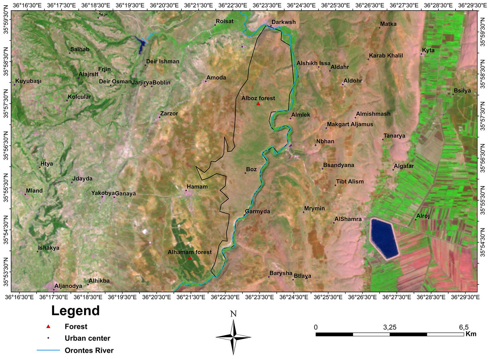
Two Syrian forests were selected to evaluate the effect of the Syrian conflict on forests. The first was Alhamam and the second was Alboz forest, both of which are located north-east of Jisr Al-Shughur city in Idlib province in Syria (Fig. 1). Topographic and climatic data for the year 2010 was obtained from a previous study looking at biodiversity and the ecological, phytosociological and demographic analyses in Northwest Syria ([1]), and these data were compared with climate data for the annual weather report to the western Idlib countryside (obtained from the local council of the city of Jisr Al-Shughour, Idlib 2019).
Fig. 1 - The map locations for Alhamam and Alboz forests sites in the Idlib region, Syria.
Estimating forest damage and loss
Aboveground biomass (AGB) estimation techniques are often used to assess forest loss and change over time. These approaches often use remotely sensed satellite image analysis to mitigate both the cost and the spatial limitations of field-based techniques. However, these methods have been demonstrated as inappropriate for forest structure characterization in high-biomass mature forests. To overcome these problems, airborne lidar data can be used in combination with forest inventory data to derive canopy height estimates, above ground biomass, canopy rugosity, mean diameter at breast height (DBH), canopy cover, terrain slope, and dominant species type ([10]).
To estimate forest damage in Syria, it was not possible to acquire airborne lidar data due to the conflict circumstances. To overcome this and to ensure an impartial and independent assessment, our research depended on four different tools to determine the forest damaged area and the drivers of this damage. The primary data collected on forest change was derived from inventory plots to identify the dominant species pre- and post-conflict in Alboz and Alhamam forests. In addition to the inventory, optical satellite image data was used to map the forest extent. The Normalised Difference Vegetation Index (NDVI) is used around the world to monitor drought, control and predict agricultural production, assist with fire prevention and map desertification. The NDVI is often used for global observation of vegetation because it compensates for changes in lighting conditions, surface slope, exposure and other exogenous factors ([27]). In this study, the NDVI was used to calculate the density of plants.
To determine drivers of the damage a questionnaire with local communities was conducted to identify the causes of the damage and to involve the local community as part of the solution to help the forests recover. To clarify some outcomes from the questionnaire and increase local engagement with forest management, more details about the damage of the forest were collected using focus group discussions with the local community, and students and university professors from Idlib Universities. Focus group discussions can be considered as an alternative technique that can help to overcome some of the limitations of individual interviews ([21]). Focus groups are invaluable for gaining access to the unique concerns and perspectives of the target audience; they are also helpful when designing experimental materials or questionnaires for more traditional laboratory or survey studies ([29]) because a group perspective can be agreed upon but also the researcher can record any discussions or disagreements between different members of the group which can be used to refine research questions and/or provide evidence that there is little consensus.
Remotely sensed satellite data analysis
Land use classifications of forest and non-forest were created for 2010 and 2017 using Landsat 5 thematic mapper image data acquired on 13 May 2010 and Landsat 8 Operational Land Imager (OLI) acquired on 16 May 2017 ([49], [50]). The resolution of satellite images was 30 m. Pre-processing of the images involved radiometric and geometric corrections ([49], [50]); the corrected imagery was further processed by creating an NDVI for each site as well as classifying the imagery into forest and non-forest classes. All remote sensing analysis was conducted using the software package ArcGIS® ver. 10.4 (ESRI Inc., Redlands, CA, USA).
The areas of Alhamam and Alboz forest sites were calculated as follows: (i) the values of NDVI values in 2010 and 2017 were calculated and classified into three categories: rock and bare soil <0.1; shrubs and meadows between 0.1 to 0.2; trees > 0.20; (ii) we converted NDVI raster data to polygons (vectors) using the “Raster to Polygons” tool; (iii) the “Merge” tool was used to merge polygons from each NDVI class together; (iv) the area of each category was calculated using the “Area calculation” tool.
Classification of the images
A supervised maximum likelihood classifier was used to create two classes, Forest and Non-Forest. Samples of forest were delineated within the images using polygons and were used to calibrate the classification model. The decision on what constituted a forest was made using expert knowledge of the region and expert interpretation of the satellite images. The samples were used in a maximum likelihood classification algorithm. The multivariate statistical approach used the reflectance values in Bands 1-5 and 7 in the Landsat 5 T M data and bands 2-7 in Landsat 8 OLI ([43]). The classification was performed in ArcGIS ver. 10.4 Image Classification toolbar which provides a user-friendly environment for creating learning samples and signature files for assisted classification purposes.
Normalized difference vegetation index (NDVI)
NDVI is used around the world to evaluate agricultural production and determine plant density ([27]). The NDVI default equation is as follows (eqn. 1):
where NIR is the pixel values of the near-infrared channel and R is the pixel values of the red channel.
The total range of the index is -1.0 to +1.0 with values between 0.1 and +1 often representing vegetation. When the value is near zero, it indicates rock and bare soil, values between 0.1 and 0.2 indicate areas of shrubs and meadows, and higher values (>0.2) indicate high-density trees. The NDVI values were scaled between 0 and 200 by adding 200 to the final NDVI values to allow for the data to be saved in an 8-bit structure which can be easily represented with a specific colour gradient or colour palette.
Forest inventory
The method of conducting the forest inventories was carried out according to Lacoste & Salanon ([24]). It is a method adopted by the International Station for Mediterranean and Alpine Plant Geography in Montpellier, France (SIGMA). We first identify the forest sites using maps and then identify plots within the forest. Forest sites were selected by considering topographic and plant homogeneity, where the phenotypic state of the plants is initially considered the best evidence in order to determine the number of inventories of the site. The basic terms for homogeneity of the plant survey were determined by the following points: (i) similarity of environmental conditions (temperature, humidity, slope, slope direction, rainfall, elevation) of the site; (ii) the dominance of one species or some plant species over others; (iii) regularity of appearance of plant species in the area of inventory that has same environmental conditions.
Within the homogenous site, the inventory or plot area was determined in a way that allows for the expression of studied site in terms of environmental specifications, geographical nature and plant diversity of the site. The area allows us to systematically carry out the inventory when we stop encountering new species, and this is called the sector or the minimum area. Often, an area of 100 m2 is used as a minimum area for the stability of the curve of increasing the species ([6], [3]).
According to Chalabi ([6], [7]) and Nahal ([36]), forest inventory is not only concerned with vegetation, but also exceeds the characteristics of the medium occupied by this cover, and therefore must determine the characteristics of the surrounding environment. The following points were all considered for the plots: (i) height above the sea level (m); (ii) topographic slope of the site, in percentage of slope angle (%); (iii) slope direction which is based on the four main directions and their derivatives (North N, South S, West W, East E), and in the case of a subdivision such as NW and so on; (iv) type of the parent rock and the properties of the soil arising on it (when possible); (v) date of the inventory; (vi) description of the forest structure by measuring heights and diameters of the middle trees, and soil coverage for the different groups of plants (grasses, shrubs and trees) expressed as a percentage ([5]); (vii) recording of the different group of plants (trees, shrubs, grasses) in tables from the forest inventories. Each species was classified by two factors, one indicating the abundance and dominance and the other indicating its sociological affinity ([6]).
Abundance and dominance factor
It was estimated from a set of five numbers ranging from 1 to 5, as follows: 5 = a large number of unspecified individuals covering more than 3/4 of inventory surface; 4 = Individuals are present in abundance covering 1/2 to 3/4 of inventory surface; 3 = species is represented by an unspecified number of individuals covering 1/4 to 1/2 of inventory surface; 2 = limited abundance of individuals covering < 1/4 of inventory surface; 1 = Individuals are somewhat abundant but their degree of coverage is weak (< 1/20) of inventory surface; + = indicates a very small number of individuals (individuals with limited presence and coverage).
Sociological affinity factor
This factor indicates the possibility of individuals of the same species to grow scattered in space or aggregated in colonies. Scattering and aggregation relate to the pattern of spreading and propagation of species as well as to local environmental conditions. Sociability was estimated by using a numerical series of five numbers ranging from 1 to 5 as follows: 5 = the plant group is almost pure; 4 = large-scale plant colonies; 3 = plant spots of the species concerned; 2 = individuals combined as bouquets; 1 = scattered individuals.
The results of the site analyses were arranged in forest inventory tables by convergence among inventory detection lists having similar species. The data were compared with the results of a similar previous study conducted in Syria pre-conflict. Furthermore, the data were compared with forest inventories tables proposed by Ellenberg in 1956 ([51]).
Questionnaires
Questionnaire data were collected from both Alhamam and Alboz sites using both paper and electronic questionnaires. The questionnaire was designed for all segments of society (male and female, different educational backgrounds, forestry specialists and non-specialists, university and secondary school students). The sample size was calculated using the Raosoft Sample Calculator ([41]). The current local populations of both sites were estimated as 5000 and the sampling framework was designed based on that recommended in Singh ([45]) and Lee et al. ([26]). The survey was conducted only once, and during this single questionnaire people were asked about their opinions on 2011 and 2018 separately. The questionnaire focused on the following: (i) the general situation of both forests (Alhamam and Alboz) before 2011 and in 2018; (ii) the damage percentage in both forests before 2011 and in 2018; (iii) the main reasons for the deterioration of forests at both sites before 2011 and in 2018; (iv) the ranking of impact factors causing the deforestation and forest damage in the region.
Statistical analysis of the response to questionnaire was carried out using descriptive data analysis tools, and data were analysed using MS Excel® (Microsoft Inc., Redmond, WA, USA). To fill the information gaps semi-quantitative data was generated by coding some of the collected responses. Furthermore, SPSS® ver. 23 (IBM, Armonk, NY, USA) was used to conduct chi-square tests to determine the main reasons for the deterioration of forests, and the Wilcoxon signed ranks test to determine the ranking of impact factors on the forests pre-2011 and in 2018.
Focus group discussions
Four focus groups were conducted to determine the current situation of the studied forests and compare it to the situation before 2011. Participants were diverse in terms of age and gender in each group. The first group consisted of the local community living next to the Alboz Forest, and the second group the community adjacent to the Alhamam forest. Both focus groups were conducted to discuss general information about forests from the local community in both sites. While the third and fourth groups were conducted to deeper discuss some of the findings of the study with forest workers in the Idlib province (third group), and the students and university professors from Idlib Universities working in related fields (fourth group).
Results
Topograph and climat
Alhamam forest is an artificial plantation forest that includes several species of trees such as Pinus pinea and Pinus brutia, as well as a few Cypress and Eucalyptus trees. It is located at an altitude of between 300 and 365 m a.s.l. ([1]) and is characterised by dense canopies. The Alboz forest is a natural forest, located in the north-east of Idlib and in the west of the Orante River valley on calcareous soil, at an average altitude of 230 m a.s.l. The forest is dominated by Oak trees and wild olives and as such has a lower density of tree canopies and a higher number of understory species (grasses and shrubs).
According to Emberger’s climatogram, the Jisr Al-Shughour station area belongs to the lower semi-humid bioclimatic zone and the moderate thermal variable. According to Bagnouls-Gaussen bioclimatic diagram (P ≤ 2T), the number of dry days is 150. The study area is different compared with the rest of the Idlib Governorate, with a clear difference in the amount of annual rain between the west and east of the study area. Rainfall is distributed irregularly during the rainy season (winter > spring > autumn > summer), as it usually begins in September and ends in May, with January as the rainiest month (Tab. 1). When comparing the climate data of 2010 and 2017 (Tab. 1), we observed no clear differences, indicating a negligible effect of climate conditions on the vegetation cover between 2010 and 2017.
Tab. 1 - Climate characteristics of Alhamam and Alboz forests in 2010 and 2017. Source: Jisr Al-Shughour city local council, annual weather report to western Idlib countryside, Idlib 2019. (P mm): amount of monthly rainfall in millimeters; (HR%): percentage of humidity; (Tc): Average monthly temperature; (mc): minimum temperature; (Mc): maximum temperature.
| Month | 2010 | 2017 | ||||||||
|---|---|---|---|---|---|---|---|---|---|---|
| Mc | mc | Tc | HR% | P mm | Mc | mc | Tc | HR% | P mm | |
| Jan | 11.3 | 4.1 | 7.5 | 80.6 | 142.9 | 12.5 | 4.5 | 8.5 | 78.9 | 120.2 |
| Feb | 13.9 | 4.1 | 8.6 | 74.6 | 104.4 | 15.3 | 6.2 | 10.75 | 69.2 | 89 |
| Mar | 17.9 | 7.1 | 12.2 | 69.9 | 95.5 | 20.4 | 12.5 | 16.45 | 49.2 | 49 |
| Apr | 23.1 | 10.3 | 16.4 | 66.9 | 50 | 26.4 | 16.9 | 21.65 | 55 | 56 |
| May | 28.3 | 14.6 | 21.3 | 55.4 | 29.7 | 29.5 | 19.1 | 24.3 | 49 | 24 |
| Jun | 31.7 | 19.8 | 25.9 | 47.9 | 7.5 | 34.1 | 22.5 | 28.3 | 47 | 9 |
Satellite image analysis
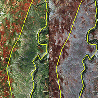
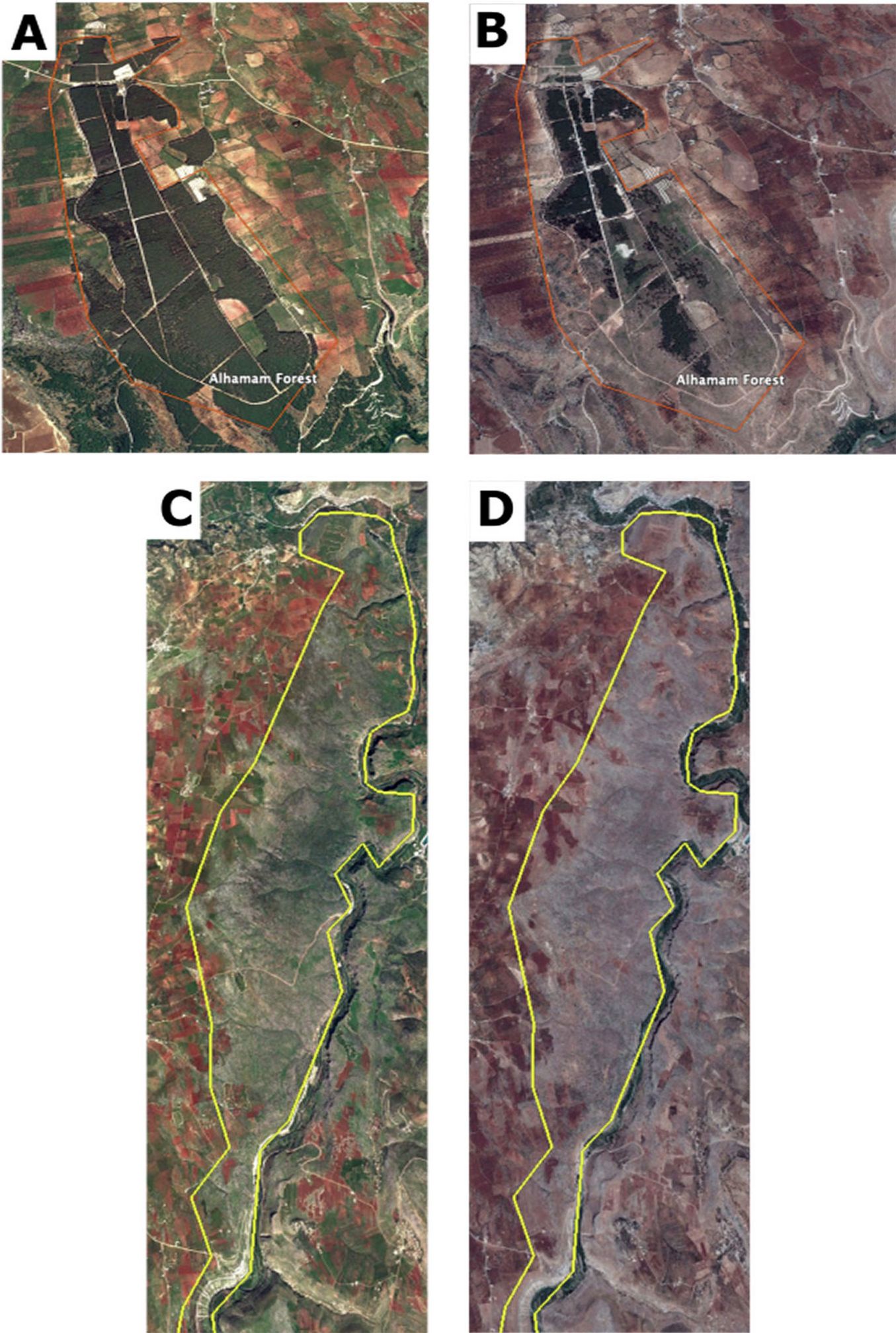
Satellite image analysis (Fig. 2) in 2017 showed that there had been significant damage to the area and density of both forests (Alhamam and Alboz) during the current Syrian conflict in comparison with maps prior to 2010.
Fig. 2 - Satellite images for (A) Alhamam in June 2010, (B) Alhamam in June 2017, (C) Alboz in June 2010, and (D) Alboz in June 2017. The 2010 images (left) show the forest conditions at both sites before the conflict and those of June 2017 (right) the forest cover after the conflict. Source: Google Earth® using MAXAR data.
Alhamam forest
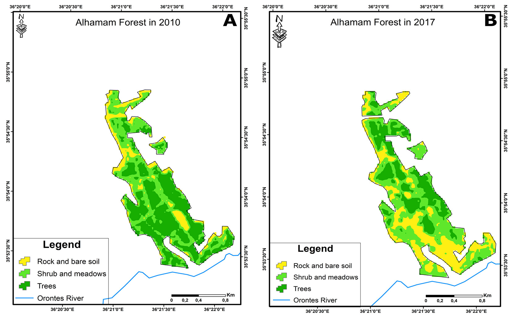
Satellite image analysis show that there had been no overall change in the total forest area in Alhamam between 2010 and 2017; in both years the forested land surface area was 179.37 ha. However, the area covered by high-density stands decreased from 87.5 ha in 2010 to 45.63 ha by 2017. The damaged area of high-density woodland was about 41.87 ha, corresponding approximately to a loss of 47.85% in seven years (Tab. 2). Satellite image analysis indicated that forest cover changed from 2010 to 2017 (Tab. 2), where the Rock and bare soil and Shrub and meadows increased from 29.24 ha to 57.78 ha, and from 62.63 to 75.96 ha, respectively (Fig. 3).
Tab. 2 - Area of Alboz and Alhamam forest sites in 2010 and 2017 (ha) according to vegetation cover classes.
| Vegetation cover class |
Alboz forest | Alhamam forest | ||||||
|---|---|---|---|---|---|---|---|---|
| Area (ha) | Change area | Area (ha) | Change area | |||||
| 2010 | 2017 | ha | % | 2010 | 2017 | ha | % | |
| Rock and bare soil | 765.09 | 812.43 | 47.34 | 6.19 | 29.24 | 57.78 | 28.54 | 97.61 |
| Shrub and meadows (understorey) | 622.98 | 745.83 | 122.85 | 19.72 | 62.63 | 75.96 | 13.33 | 21.28 |
| Trees (main storey) | 209.16 | 38.97 | -170.19 | -81.37 | -87.50 | 45.63 | -41.87 | -47.85 |
| Total | 1597.23 | 1597.23 | - | - | 179.37 | 179.37 | - | - |
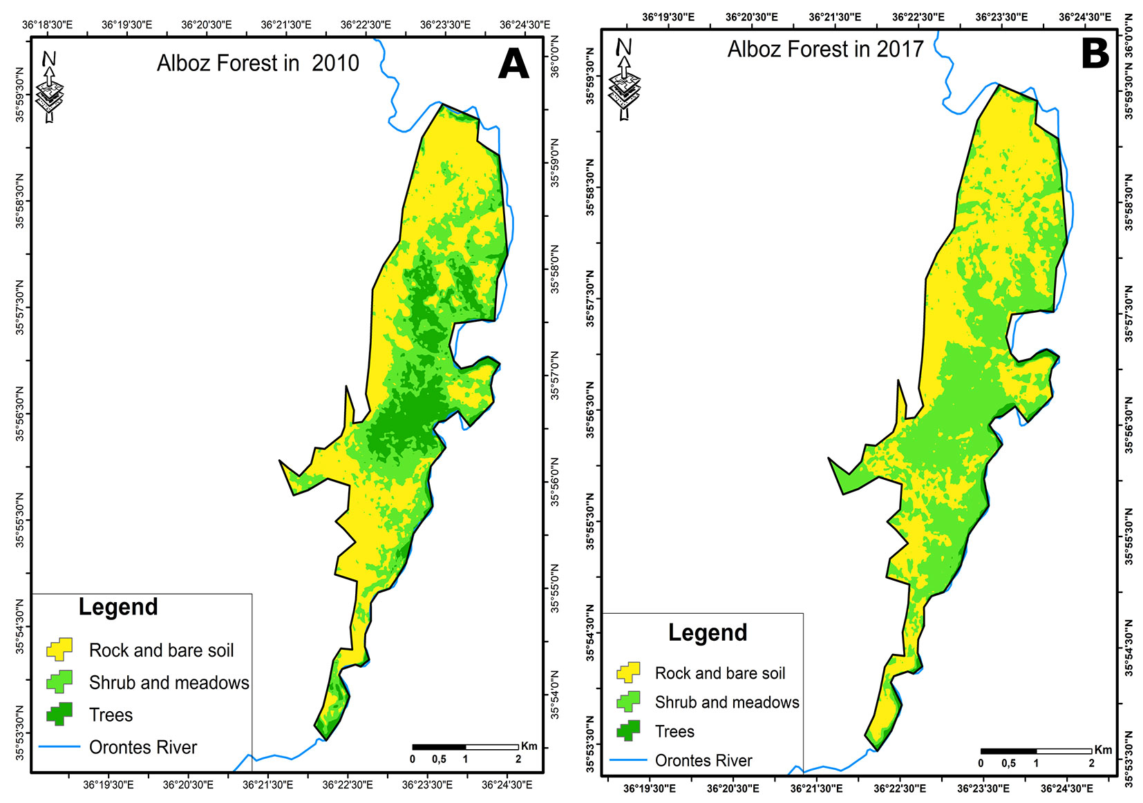
Fig. 3 - (A) Vegetation cover classes at Alhamam forest in 2010 estimated using Landsat 5 TM data and a maximum likelihood classification; (B) Vegetation cover classes at Alhamam forest in 2017 estimated using Landsat 8 OLCI data and a maximum likelihood classification.
Alboz forest
The results of the satellite image analysis indicated that there had been no change in total forest area at the Alboz site between 2010 and 2017, being 1597.23 ha in both years. However, the area actually covered by trees decreased from 209.16 ha in 2010 to 38.97 ha in 2017, corresponding to a loss of forest cover of 170.19 ha (-81.37% - Tab. 2). In contrast, the Rock and bare soil and Shrub and meadows area has increased from 765.09 ha to 812.43 ha and from 622.98 ha to 745.83 ha, respectively (Fig. 4).
Fig. 4 - (A) Vegetation cover classes at Alboz forest in 2010 estimated using Landsat 5 TM data and a maximum likelihood classification; (B) vegetation cover classes at Alboz Forest in 2017 estimated using Landsat 8 OLCI data and a maximum likelihood classification.
Forest inventory
Forest inventory results indicated that dramatic changes occurred in both study sites between 2012 and 2018. These results are described in detail below for each site separately.
Alhamam forest
This is a forest site subject to afforestation in 1990 with species such as Pinus brutia Ten., P. pinea L., P. halepensis Mill., Cupressus sempervirens L. and Eucalyptus camaldulensis Dehnh. The inventory in 2012 showed a high tree density and the rare presence of accompanying herbs and shrub species, such as Dorycnium hirsutum, Poterium spinosum, Thymbra spicata, Origanum syriacum, Cistus villosus, Cistus salviifolius. Some species of Orchidaceae and Araceae were observed in winter and spring, and Quercus calliprinos L. (a native species expected to be prevalent in the region) was also observed on the site edges, especially in the south and east.
The results of the inventory carried out in 2018 revealed two distinct areas covered by different forest types. In the first area large trees had been completely cut down; natural regeneration and seedlings of a large numbers of species were observed, especially Pinus brutia and Cupressus sempervirens along with natural herbaceous and shrub species in strong competition for light, such as Poterium spinosum, Calicotome villosa, Capperis spinosia, Micromeria myrtifolia, Avena barbata. The second area had no felling of trees, and the main tree species used for afforestation were dominant. Here, natural regeneration and understory species were very rare due to the dense canopy. Some accompanying species grow at the forest edges, e.g., Quercus calliprinos, Pistacia palaestina, Phillyrea media, Rhaminus palaestina, along with some seedlings of P. brutia, C. sempervirens and P. pinea.
Alboz forest
The results of the inventories carried out in 2012 showed the dominance of Quercus calliprinos, which was estimated to be present in both its shrubby and adult forms. The site was mainly characterized by a Mediterranean vegetation understory, though several trees of Quercus infectoria and some other species belonging to the upper Mediterranean vegetative zone were observed in the northern part and in the most protected places. The presence of species of the upper zone and the richness in biodiversity can be explained by the Orontes River and its tributary springs, which ensure water abundance and atmospheric humidity in the area, although it is located close to Darkosh, which belongs to the temperate semi-arid bioclimatic zone.
The 2018 inventory indicated that the vegetation coverage decreased from 10-80% in 2012 to 0-10% and it did not exceed 5% over the whole site. Tree heights of Quercus calliprinos and Laurus nobilis did not exceed 1.5-2 m in height and 5-10 cm in diameter. There were no trees, but very small bushes scattered on the ground. Also, results of the 2018 inventory showed a reduced species diversity and a decrease in plant coverage ratio, abundance dominance and sociological affinity factors, as compared with that inventoried in 2012.
Questionnaires
The vast majority of respondents to the questionnaire reported about a great disparity in the situation of the two forests analyzed (Alhamam and Alboz) before the conflict (2011) and the situation in 2018. All of the participants considered the situation of both forests was “good” and “very good” before 2011, while the current situation (2018) was “bad” and “very bad” (Fig. 5). In addition, the perception of damage was estimated at 0-20% in both forests before the conflict, while after seven years of conflict it increased to 80-100% in Alboz and 60-80% in Alhamam forest (Fig. 6).
Fig. 5 - The status of both studied forests (Alboz and Alhamam) before and after 2011, according to the respondents to the questionnaire.
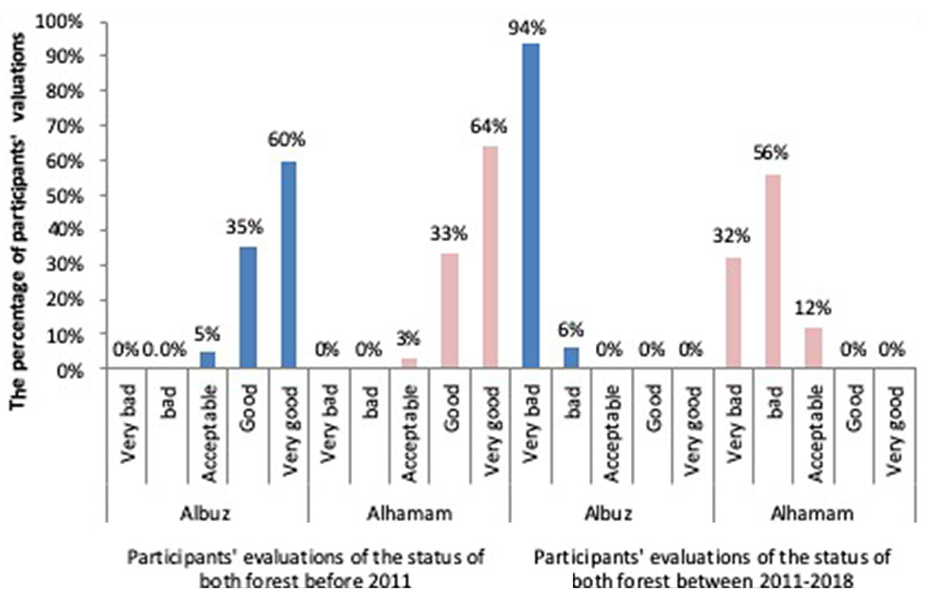
Fig. 6 - The percentage of damage to both studied forests (Alboz and Alhamam) before and after 2011, according to the respondents to the questionnaire.
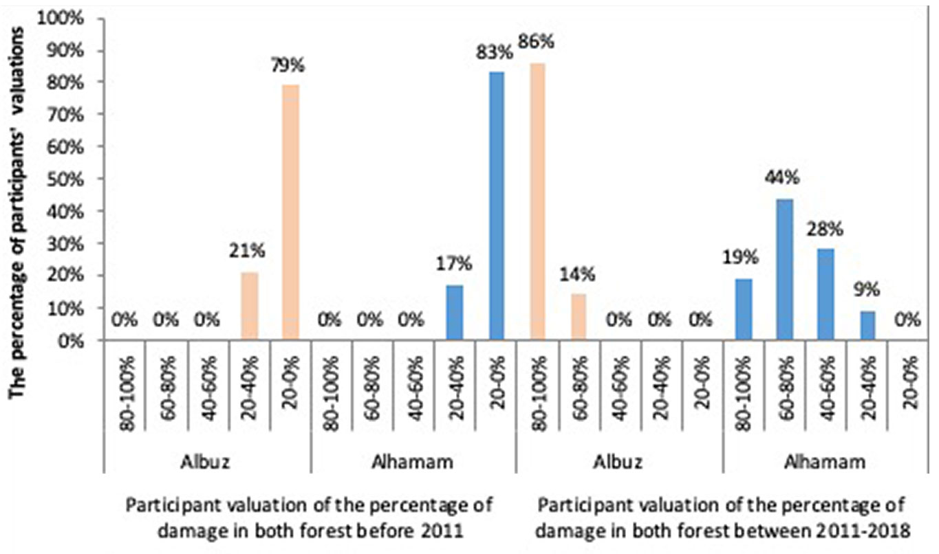
Likewise, the responses indicated that the damage rate at Alboz was greater than that at the Alhamam site. Chi-square tests showed that the cutting down of trees is perceived to significantly affect the damage dimensions in both forests in 2018. Fires resulting from acts of fighting was thought to be significant only in the Alboz site. Overgrazing was also thought to have had a significant effect on size of the damage for Alboz before the conflict in 2011 (Tab. 3).
Tab. 3 - Responses to the questionnaire about the main reasons (and their impact) of deterioration of Alhamam and Alboz forests in 2018 and before 2011. Legend: 1, Absolutely disagree; 2, Disagree; 3, Neutral; 4, Agree; 5, Absolutely agree.
| Site | Practice | In 2018 | Before 2011 | ||||||||||
|---|---|---|---|---|---|---|---|---|---|---|---|---|---|
| 1 | 2 | 3 | 4 | 5 | χ2 test | 1 | 2 | 3 | 4 | 5 | χ2 test | ||
| Alhamam | Cutting trees | 0 | 0 | 0 | 20 | 80 | 0.03 | 0 | 4 | 81 | 14 | 1 | - |
| Overgrazing | 0 | 2 | 55 | 37 | 6 | 0.144 | 0 | 9 | 72 | 19 | 0 | 0.346 | |
| Natural fire | 55 | 45 | 0 | 0 | 0 | 0.052 | 63 | 36 | 1 | 0 | 0 | 0.541 | |
| Intended fire | 10 | 77 | 11 | 2 | 0 | 0.52 | 3 | 79 | 18 | 0 | 0 | 0.275 | |
| Fires from acts of fighting | 0 | 3 | 46 | 39 | 12 | <0.01 | - | - | - | - | - | - | |
| Alboz | Cutting trees | 16.19 | 24.76 | 59.05 | 0 | 0 | <0.01 | 11.43 | 4.76 | 74.29 | 8.57 | 0.95 | 0.675 |
| Overgrazing | 0 | 6.67 | 62.86 | 30.48 | 0 | 0.457 | 0 | 2.86 | 79.05 | 17.14 | 0.95 | <0.01 | |
| Natural fire | 44.76 | 51.43 | 0.95 | 0.95 | 1.9 | 0.8 | 68.57 | 29.52 | 1.9 | 0 | 0 | 0.238 | |
| Intended fire | 0.95 | 63.81 | 13.33 | 0.95 | 20.95 | 0.229 | 24.76 | 58.1 | 17.4 | 0 | 0 | 0.56 | |
| Fires from acts of fighting | 31.42 | 35.24 | 31.43 | 1.9 | 0 | 0.1 | - | - | - | - | - | - | |
Wilcoxon signed ranks test (Tab. 4) showed that there were several drivers of damage that were significantly different from 2011 to 2018, as derived from the local community engagement through the focus groups and questionnaire. A yes/no question asked respondents to state if military action had a significant impact on deforestation. The majority of respondents answered “No”. A multiple-choice question asked respondents to select from a pre-formed list of possible drivers of deforestation, which was prepared by reviewing the literature. The list of drivers was further investigated by focus groups composed by people not involved throught the questionnaire. The drivers identified were: (i) deficiency in fuel for heating; (ii) lack of strict laws about cutting the forest trees; (iii) lack of law compliance by the local community; (iv) lack of research studies about the importance of forest; (v) some local investors and local leaders cutting trees for building; (vii) lack of staff in forest management and human activities related to agriculture. The only factor that was not significantly changed since 2011 was the lack of awareness about the importance of forests, indicating that awareness had not changed throughout the period.
Tab. 4 - The ranking of impact factors on the forests sector at the studied sites.
| Impact factors | Respondents (%) | Wilcoxon Signed Ranks Test |
|
|---|---|---|---|
| 2018 | Pre-conflict (2011) |
||
| Deficiency in fuel for heating | 96 | 9 | <0.01 |
| The unemployment | 93 | 45 | <0.01 |
| Lack of strict laws about cutting the forest trees | 87 | 8 | <0.01 |
| Lack of compliance by the local community by the laws | 68 | 31 | <0.01 |
| Lack of awareness about the importance of forests | 50 | 43 | 0.08 |
| Lack of research studies about the importance of forest | 48 | 9 | <0.01 |
| Some local investors and local leaders cut trees of the forest for building | 47 | 31 | <0.01 |
| Lack of staff in forest management | 24 | 4 | <0.01 |
| Human activities related to agriculture | 16 | 6 | 0.02 |
Focus groups
According to focus groups discussions, participants agreed that the forest damage was more than 50% in the Alhamam forest, while it was approximately 90% in the Alboz forest.
Alhamam forest
The participants to the focus groups agreed that at the beginning of the Syrian conflict, the Alhamam forest became highly unstable. This site was exposed to several violations since 2012, such as cutting of trees, conversion to agricultural land, grazing and wildfire. Furthermore, the site was bombed by two rockets in 2012 which led to considerable areas of destruction. Furthermore, in October 2018 the site was exposed to a large fire because of the training of one of the army groups inside the site with live ammunition.
Alboz forest
The participants agreed that the growing conditions of the forest in 2018 were also very poor. The site had been exposed to similar damage, cutting the trees, conversion to agricultural land and overgrazing by goats. These factors led to a sharp decrease in plant coverage, with the presence of bushes in the form of small scattered bouquets remaining in 2018.
Discussion
The Syrian conflict was the biggest war in modern history with a massive death count and an unprecedented amount of destruction. However, little attention has been paid to how the war affected the environment and ecology. The main aim of this study was to evaluate the damage since 2011 in Alhamam and Alboz forest sites in Idlib province of Syria. The study developed an approach to damage assessment by combining different data sources to provide a rich understanding of the situation, changes over time and drivers of these changes. Forest inventories were used to determine deterioration and decline in the plant biodiversity, remotely sensed satellite image analysis to determine the damage size and plant cover density, while questionnaires and focus groups were conducted to determine the direct and indirect causes for the deterioration of forests. Our method combining satellite image analysis, plot inventories, questionnaires and focus groups was able to identify these regions and the actual reasons for the forest loss.
In a previous study, Gorsevski et al. ([17]) used satellite imagery in South Sudan to evaluate changes on the landscape during and after the war; they also conducted key informant interviews from local communities to explain the underlying drivers of these observed changes in land use and land cover. Conflicts in many countries such as, Papua New Guinea, Indonesia, Indochina, Myanmar, Sri Lanka, Central Africa, the Amazon, Colombia, Central America, and New Caledonia, have caused negative impacts on biodiversity ([30]). In the present study, forest inventories showed deterioration and decline in plant biodiversity, with the loss of important native species which were replaced by others with lower pastoral or economic value.
In the present study, the analysis of forest inventory tables indicates a regressive succession of the plant community in both Alhamam and Alboz sites, as reflected by the degradation of the tree layer (main storey) at both sites, which in turn provoked a decline or imbalance in biological diversity. Nonetheless, the forest at both sites showed the typical secondary succession occurring after the former community collapses due to fires, unregulated felling and overgrazing. The secondary succession at both sites is mainly composed by xerophytic and light-demanding species which colonize the bare soil, but also by natural regeneration (seedlings) of the dominant tree species. This is confirmed by the analysis of the aerial photographs at both sites (Fig. 3, Fig. 4, Tab. 2), which show a marked increase in the shrub and meadows and bare soil cover classes between 2010 and 2017.
Comparison to other conflict zones
Our study revealed that tree cover loss in in the AlBoz forest was approximately 81% of the total forested area, corresponding to 170.19 ha. Similarly, the area of high-density forest in Al-Hamam forest decreased from 87.5 ha in 2010 to 45.6 ha in 2017. The estimated damaged area, i.e., where significant reductions in tree density occurred, was about 41.9 ha, corresponding to a loss of about 48% of the high-density woodland existing prior to the conflict. These results suggest that the main driver of the damage and deforestation was the increase in the demand for fire-wood due to a lack of fuel oil. The reduced availability of fuel in local markets led to a subsequent increase in prices, making fuel unaffordable to many households as a consequence of increased unemployment and reduced household incomes. Our results (Tab. 4) showed that there were several drivers of damage that were significant: (i) the absence of strict laws on tree logging and harvesting; (ii) the lack of compliance to rules by the local community; and (iii) the lack of staff in forest management and patrolling. This broadly supports the work of other studies in this area which link the economic hardship and weak institutions as major drivers for deforestation at the local level during the conflict.
Most deforestation was determined by heavy logging as a result of the increasing demand by the local population or the surrounding urban area for firewood and charcoal. Indeed, similar reasons for deforestation were identified in other regions of Syria ([32]). The results of the Focus group from Idleb show that the local community knowledge on the importance of the forests is not diminished and laws are not changed during the conflict. Evidence indicates that once other sources of fire wood had been exhausted (internal doors, furniture, plastic waste), the community had to use the woodland resources.
Deforestation is an ongoing concern in many countries both during an active conflict as well as post-conflict, with many of the drivers linked either directly or indirectly to the conflict ([9]). Forest cover in the Andes-Amazon region of Colombia during the conflict between 1988 and 2019 decreased by 19% due to illicit land uses such as coca cultivation and illegal cattle ranching ([35]). In Myanmar there was a proliferation of logging for export, apparently as a revenue stream for the military junta ([2]). In the Democratic Republic of Congo, there has been an 8% increase in forest loss since 2019 due to weak governance and a lack of a national plan to combat deforestation as a result of the long running conflict ([9]). In South Sudan forest loss was primarily driven through illegal charcoal burning by displaced populations, but also via the illegal trade in timber by foreign firms ([9]). In Senegal the Illegal logging of rosewood for exports resulted in the estimated removal of 1.6 million trees between 2012 and 2020 ([11]). These results corroborate our findings and the evidence from focus groups.
Comparison with previous studies in Syria
Two previous studies carried out in Syria were focused on: (i) studying the effects of the armed conflict on the changes in land use and land cover since 2011 ([31]); and (ii) studying the dynamics of forest cover and its relationship with the physical, social and demographic changes in the Syrian coastal region of Hama and Latakia Governorates ([32]). Both studies relied on the analysis of multi-temporal Landsat images, combined with population statistics, and topographical and climatic factors.
Deforestation and tree density loss in Hama and Latakia governorates of Syria were determined as a result of socio-economic factors linked to the conflict ([32]), such as agricultural expansion, forest fires, illegal logging, charcoal production, and increased built land partly from population expansion from migration.
In our study, we used the combination of results from multiple methods (forestry surveys, household questionnaires, focus groups and statistical analyses) to understand the drivers of forest changes in Idleb. Compared to the study mentioned above, our results provide more details on the reasons underlying the exploitation of forest resources by local communities.
Relying solely on remotely sensed data or land cover classifications does not allow for accurate estimations of forest damage and loss in Syria. The study by Mohamed ([32]) using remotely sensed imagery over the entire Syria reported an increase in the forest area of 2576 km2 by 2018. This is in contrast with our findings, which revealed a decrease in the forested area. The difference in the results can be explained by the fact that the author classified new plantations of fruit trees as low-density forests. The study confirmed that the local population and the newly arrived immigrants cultivated the lands near the forests but typically planted fruit trees here for commercial use. The above misclassification confirms that relying only on remotely sensed products such as the GFW or land cover classification from Landsat is inappropriate, especially in places like Syria with low-density natural forests. This could lead to underestimation of the total forest loss or damage in these regions. Therefore, field surveys are recommended to determine the actual changes in the forest cover.
Mohamed et al. ([31]) indicated that the main drivers of deforestation were human activities and the demographic changes that occurred in Syria after 2011. These findings are consistent with our results in that one of the main and direct drivers of deforestation was the need of local people for firewood, combined with the reduced forest protection due to the weakening of local institutions.
Comparison to global forest change products
The Global Forest Watch estimations, which are derived from the Hansen Global Tree Cover loss data product, indicates that there has been a 48% loss in tree cover in Idlib between 2000 and 2018. Furthermore, the loss in the same area was near 23% from 2010 to 2018 ([16]). Our results indicate a much larger loss of tree cover in the same period (2011-2018). The Hansen Tree Cover loss data product uses a threshold of 30% cover to identify an area as forest woodland. This means that the Alboz forest area in Idlib has not been classified as a forest. On the contrary, the inventory data and local stakeholder engagement revealed this to be an important natural oak forest with low density cover. Given that the Alboz forest is not included in the Hansen Forest Cover and Loss product, the estimated deforestation in Idlib (48%) is underestimated. This has important consequences for forest monitoring as extensive regions of oak forests with low tree cover density can be found across Syria. Thus, it is likely that the forest loss estimations across the country are underestimates.
The satellite image analysis carried out in this study indicated that there was a much larger loss of tree cover, especially in high-density forest area (i.e., 99% in Alboz and 48% in Alhamam forest). Furthermore, maps, questionnaire and focus group discussions indicated that the damage size in Alboz was higher than that in Alhamam, probably because army groups are established at the latter site, which partly contributed to the protection of the Alhamam forest. However, it is clear that the overall situation of the studied sites is very poor, especially where the sites had been subjected to all forms of infringement.
Focus group discussions revealed that the need for fuel for heating led to excessive cutting of trees and shrubs and was followed by removal of root systems from the ground when the amount of above ground biomass was depleted. Moreover, other forest damages are caused by goat overgrazing and conversion of forest land to agricultural activities. As expected, the decrease in tree density was higher on the roadsides and in more accessible places. In addition, questionnaires and focus group discussion indicated that these forests are close to many villages, and this contributed to increase the access and the forest damage.
Our study suggests that the overgrazing was the main reasons for the deterioration of Alboz forests before 2011. This finding is consistent with that of Radford et al. ([40]) who evaluated the challenges that the Syrian forest faced before the conflict.
The results of maps analysis were confirmed by the results of forest inventories, questionnaires and focus groups discussion, which pointed out the serious damage occurred to Alboz and Alhamam forests during the conflict in Syria between 2011 and 2018. Among the causes of the loss of tree cover at the former site, fires resulting from acts of fighting have been also reported. Further, forest inventory was of great importance in determining the kind of damage to biodiversity which cannot be performed using satellite image analysis.
Overall, the reduction in tree cover at both sites is alarming and the deforestation will likely continue until fuel oil and jobs become more readily available in the area. Given the definition of forests in the GFW products it is clear from these results that local studies will be required across Syria to estimate the damage to forests before any reforestation can be planned.
Conclusion
This study estimated the change in forested areas for two sites in Idlib, Syria between 2010 and 2017 by using a triangulation approach. Satellite image analysis revealed that the Global Forest Watch underestimated forest loss in this region, due to the large area of low-density oak forests in Idlib region which were not classified as woodland in the GFW product.
Deforestation in the studied area markedly increased due to the need of local population for firewood, in the absence of other sources of fuel. Local knowledge of importance of forests and their protection status did not change during the conflict, and this indicate that governance and institutions weakened by the conflict were unable to prevent the damage and deforestation.
Acknowledgements
This project was funded by CARA, the Council for Academics at Risk, through the grant “A Primary Evaluation of Syrian Forest Damage since 2011”. We would like to thank the field team in Syria to support our study by data collection and inventory.
References
Gscholar
Gscholar
Gscholar
Online | Gscholar
Gscholar
CrossRef | Gscholar
Gscholar
Gscholar
Gscholar
Gscholar
Gscholar
Gscholar
Gscholar
Online | Gscholar
Gscholar
Authors’ Info
Authors’ Affiliation
Idleb University, Idleb (Syria)
School of Geosciences, University of Edinburgh, Edinburgh, Scotland (UK)
Corresponding author
Paper Info
Citation
Aldakhil M, Abdullateef S, Mahmoud F, Alhasan A, Lakmes A, Al Abdullah M, Watmough GR (2023). A primary evaluation of Syrian forest damage since 2011: a case study of Alhamam and Alboz forest sites. iForest 16: 144-154. - doi: 10.3832/ifor4032-016
Academic Editor
Paola Mairota
Paper history
Received: Dec 02, 2021
Accepted: Feb 28, 2023
First online: May 30, 2023
Publication Date: Jun 30, 2023
Publication Time: 3.03 months
Copyright Information
© SISEF - The Italian Society of Silviculture and Forest Ecology 2023
Open Access
This article is distributed under the terms of the Creative Commons Attribution-Non Commercial 4.0 International (https://creativecommons.org/licenses/by-nc/4.0/), which permits unrestricted use, distribution, and reproduction in any medium, provided you give appropriate credit to the original author(s) and the source, provide a link to the Creative Commons license, and indicate if changes were made.

Web Metrics
Breakdown by View Type
Article Usage
Total Article Views: 32312
(from publication date up to now)
Breakdown by View Type
HTML Page Views: 25812
Abstract Page Views: 3281
PDF Downloads: 2778
Citation/Reference Downloads: 4
XML Downloads: 437
Web Metrics
Days since publication: 1150
Overall contacts: 32312
Avg. contacts per week: 196.68
Article Citations
Article citations are based on data periodically collected from the Clarivate Web of Science web site
(last update: Mar 2025)
Total number of cites (since 2023): 1
Average cites per year: 0.33
Publication Metrics
by Dimensions ©
Articles citing this article
List of the papers citing this article based on CrossRef Cited-by.
Related Contents
iForest Similar Articles
Review Papers
Remote sensing-supported vegetation parameters for regional climate models: a brief review
vol. 3, pp. 98-101 (online: 15 July 2010)
Review Papers
Accuracy of determining specific parameters of the urban forest using remote sensing
vol. 12, pp. 498-510 (online: 02 December 2019)
Review Papers
Remote sensing of selective logging in tropical forests: current state and future directions
vol. 13, pp. 286-300 (online: 10 July 2020)
Technical Reports
Detecting tree water deficit by very low altitude remote sensing
vol. 10, pp. 215-219 (online: 11 February 2017)
Research Articles
Assessing the environmental factors affecting the natural regeneration of Cedrus libani A. Rich. in Jawbat Burghal, Syria
vol. 19, pp. 237-243 (online: 14 June 2026)
Research Articles
Geostatistical techniques for estimating aboveground biomass in eastern Amazonia
vol. 19, pp. 85-93 (online: 13 March 2026)
Research Articles
Assessing water quality by remote sensing in small lakes: the case study of Monticchio lakes in southern Italy
vol. 2, pp. 154-161 (online: 30 July 2009)
Research Articles
Afforestation monitoring through automatic analysis of 36-years Landsat Best Available Composites
vol. 15, pp. 220-228 (online: 12 July 2022)
Review Papers
Remote sensing support for post fire forest management
vol. 1, pp. 6-12 (online: 28 February 2008)
Technical Reports
Remote sensing of american maple in alluvial forests: a case study in an island complex of the Loire valley (France)
vol. 13, pp. 409-416 (online: 16 September 2020)
iForest Database Search
Search By Author
Search By Keyword
Google Scholar Search
Citing Articles
Search By Author
Search By Keywords
PubMed Search
Search By Author
Search By Keyword


