Reforestation and land use change in a drainage basin of southern Italy
iForest - Biogeosciences and Forestry, Volume 6, Issue 4, Pages 175-182 (2013)
doi: https://doi.org/10.3832/ifor0741-006
Published: May 08, 2013 - Copyright © 2013 SISEF
Research Articles
Abstract
In this study, the land use change in a large basin of Calabria region (southern Italy) subjected to extensive reforestation at the end of the ’50 has been carefully reconstructed and compared with the current situation. The runoff capacity of the basin was estimated using data available for the temporal periods before and after the reforestation interventions. The results show that the surface of the basin interested by former reforestation activities did not affect the runoff, probably due to a trade-off between the effects of reforestation and a concurrent increase in urbanized and degraded areas. Indeed, the hydrological response is linked to structural complexity of reforested areas, currently at an early stage of development that can be further promoted through forest management activities.
Keywords
Introduction
Reforestation is the entire process of forest constitution or regeneration even if no trace of the old forest remains ([23]). The achievement of this objective is based on criteria related today to restoration ecology, which includes all those activities aiming at ecologically improving degraded, damaged or destroyed environments ([25]). It follows that reforestation should be treated as an input into the restoration of a natural system ([12]), given that human intervention is the starting point of the process of forest recovery. Soil preparation, sowing or planting and early post-implantation activities are the beginning of a process whose effects become progressively evident since the early years, provided the anthropogenic activities are controlled and natural disturbances (fire, grazing) do not occur ([17]). Over time, forest cover modifies the microenvironment leading to microclimate changes and contributions of organic matter to the soil.
These processes are the first functional relationships between vegetation and environmental factors of the site, becoming more evident when naturalization is triggered by the presence of species characteristic of the later stages of ecological succession ([4]).
Ecosystem recovery can be considered complete when an artificial system implanted in a degraded environment acquires a set of ecological characteristics, following an evolutionary trajectory leading to an increased structural and functional complexity ([25]). Consequences of reforestation are of ecological, landscape and economical types. In particular, several hydrological consequences can be identified among ecological effects: protection of the soil from water erosion, increase of soil storage capacity, increase of basin lag time and corresponding decrease of ordinary peak flows ([21]). In qualitative and quantitative terms, the role of reforestation on hydrological response is related to the percentage of reforested area, physiognomic types, chronological stage of the population (with reference to possible evolutionary dynamics), and dendro-auxometric characteristics of the population ([6], [24]).
The above considerations become very important in relation to past and current role that reforestation plays in land management ([22], [28]). Calabria is an area of particular interest for this type of investigation. In this region, after the catastrophic floods of the last century, also due to forest destruction, specific laws were adopted aiming at a comprehensive soil conservation plan, and extended hydrological and forestry activities, including the reforestation of river hills and mountains, were carried out. The above activities affected large areas characterized by soils derived from a variety of geological formations on very steep and heavily eroded slopes. The reforestation interventions implemented from 1958 to 1970 affected overall 120 000 ha, representing about 30% of the area reforested in Italy during the same period.
In this study the land use in the Coscile basin (southern Italy) has been carefully reconstructed and compared, in order to assess the aptitude of the basin to produce runoff before and after the extended reforestation started at the end of the fifties. The runoff capacity of the basin was evaluated based on the main historical sources available for land use ([7], [9], [13]).
Material and methods
Study area and data collection
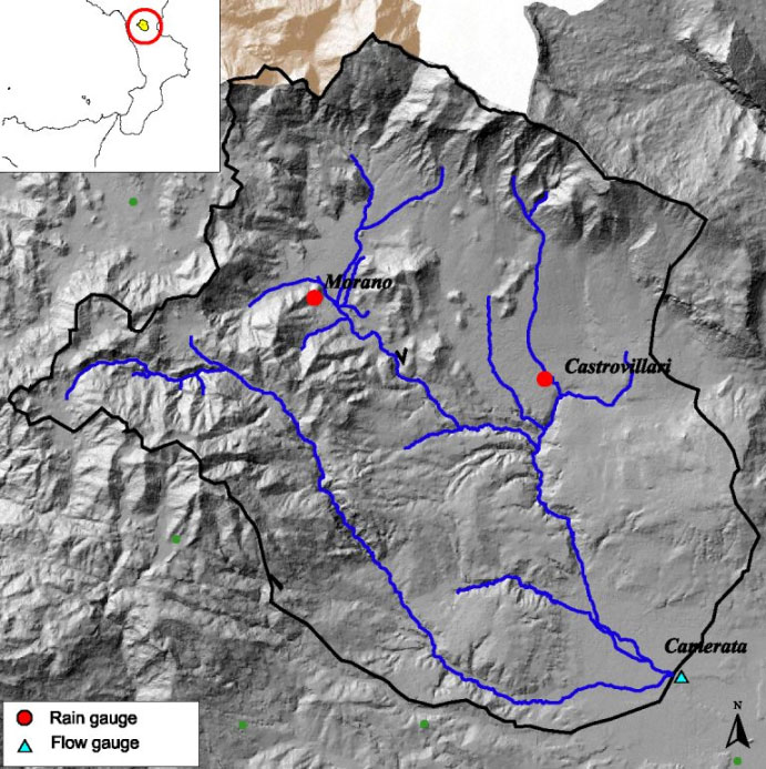
The Coscile River is the most important tributary of the Crati River in the northern part of Calabria (Fig. 1). Arising from the Pollino massif, the Coscile River drains most of the northern Calabrian Apennines, flowing for about 50 km east into the Crati River near its mouth, in the plain of Sybaris.
In this paper, the Coscile Basin refers to the section of Camerata, where a runoff gauge is located corresponding to an area of 277 km2 (at 39° 43’ 00” - 39° 55’ 20” N, 16° 16’ 09” - 16° 16’ 00” E). The Coscile River is 31 km long and its main tributary, the Garga, is about 25 km long. The basin includes most of the mountainous formations of northern Calabria. Its valley, initially, has a north-east direction, and originates from the intersection of the chains of the Apennines and Calabrian Pollino. Then the valley tends towards the east as the gradient levels into a flat plain at the confluence with the Crati River.
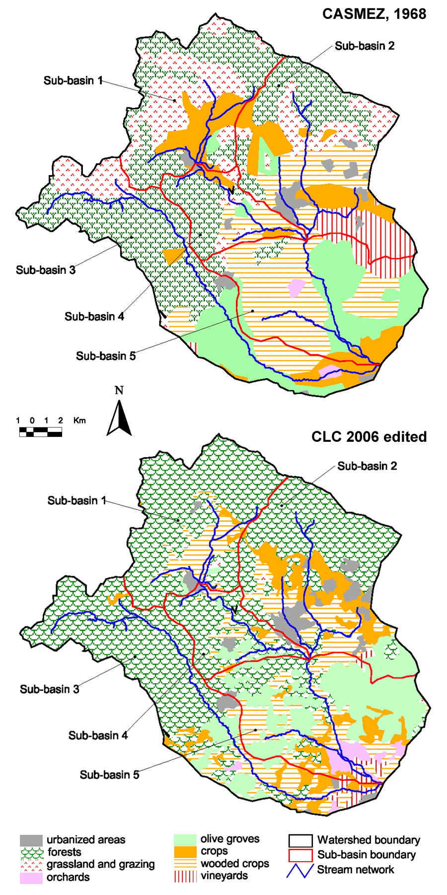
As regards the land use, historical data derived from the map implemented by Cassa per il Mezzogiorno for the Calabria region in the period 1955-67, following the special legislation n° 1177 ([9]), were used. CLC ([13]), further supplemented with interpretation of digital orthophotos (Fig. 2), has been used for assessing current land use ([2], [19], [20]). Other historical data of land use have been derived from the Piano Regolatore di Massima per la Calabria ([7]).
Archives ([8]) and literature ([11], [18]) have been used to obtain information concerning to reforestation techniques at specific sites. The Calabria soil map ([3]) provided the hydrological soil group and soil drainage condition.
Rainfall and flow data, measured at the outlet section in Camerata, were collected by the Centro Funzionale Multirischi for the Calabria region ([10] - ⇒ http://www.cfd.calabria.it). The dataset has been integrated with information obtained from other historical publications by the former Servizio Idrografico e Mareografico Nazionale, related to previous periods and/or to variables derived from the basic data. In detail, average areal annual rainfall and runoff data for the periods 1928-30, 1932-40 and 1960-69 were obtained from publication “Dati caratteristici dei corsi d’acqua italiani” ([26]). These historical data were integrated with information on daily rainfall and discharge obtained from the Annali Idrologici of SIMN for the period 1970-84.
Methods
A preliminary analysis of the historical and current land use patterns was performed to determine the percentage of reforested areas related to other land use types. The variation in the reforestation percentage was evaluated by the woodiness index (i.e., the ratio between the wooded area and the total area of the basin). Areas identified as reforested areas have been verified by field surveys, which allowed a more detailed classification of reforestation, as those with Mediterranean pines (Aleppo pine - Pinus halepensis Mill., Umbrella pine - Pinus pinea L., Maritime pine - Pinus pinaster Aiton), with Black pine - Pinus nigra Arnold (Austrian black pine - Pinus austriaca Höss Novak) and Calabrian pine - Pinus laricio Poiret. In this step, the current average density of stands has been also verified.
The highly degraded forested areas were analyzed separately, by merging areas where reforested zones and natural forests have been almost entirely destroyed by repeated and intense fires and/or grazing. To ensure comparability of analogous data from CASMEZ ([9]) and CLC ([13]), some CLC classes of land use related to agricultural areas, wooded lands and semi-natural environments were merged (Tab. 1). Nevertheless the detailed information derived from CLC ([19]), the analogous comparison for woodlands has been limited to their total surface due to the poor information obtained from the CASMEZ legend map.
Tab. 1 - Correspondence of land use types between the CASMEZ map ([9]), integrated by the Piano regolatore di massima per la Calabria ([7]), and Corine Land Cover ([13]).
| CASMEZ ([7], [9]) | CORINE LAND COVER ([13]) |
|---|---|
| Urbanized areas | Urbanized areas |
| Vineyards | Vineyards |
| Orchards | Orchards |
| Olive groves | Olive groves |
| Arable crops with trees | Heterogeneous agricultural areas (Annual crops associated with permanent crops + Complex cultivation patterns + Agro-forestry areas) |
| Arable crops | Arable crops |
| Pasture | Natural grassland |
| Forested degraded areas | Highly degraded forest areas |
| Forest | Forest areas |
| Reforestation | Reforestation |
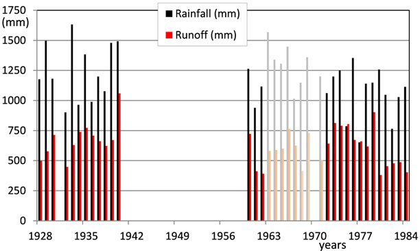
Concerning the hydrological data of Coscile River at Camerata station, the monthly and annual values of runoff and areal rainfall have been obtained directly from SIMN. Actually, the Annali Idrologici indicate some uncertainties related to the runoff data of the Coscile River at the Camerata flow gauge. In particular, from 1963 to 1971, the water balance was altered by occasional water diversion upstream of the flow gauging station for irrigation from April to September. From 1936 to 1940, to take into account the same type of water diversion, the balance was adjusted by SIMN with different discharge amounts for various periods of the year (0.45 m3 s-1 or 0.90 m3 s-1 in different months). In addition, Coscile River was used since 1967 for hydro-electrical power production, with flow restitution upstream of the flow gauge. Based on these various reports, by excluding any year in which the altered balance cannot be quantitatively taken into account, the time spans 1928-40, 1960-62, 1972-84 (28 years) have been considered for further data processing. In particular, 1928-40 has been considered as “before reforestation” period, and the remaining ones as “after reforestation” period.
Land use changes have also been studied in order to assess the attitude of an area to produce runoff, that can be quantified through the synthetic parameter Curve Number (CN - [29]). The procedure adopted to estimate the CN is the following:
- identification of the hydrologic soil group. The attribution of soil infiltration values in the four classes was performed by overlaying the soil map of Calabria ([3]) and linking each pedological class to different land uses and infiltration characteristics of the soil;
- land use attribution;
- identification of drainage conditions. The three classes (poor, fair, good) were derived from the soil map described above;
- attribution of initial conditions of soil saturation. Antecedent Moisture Condition II (AMC II) was used since it refers to normal conditions ([29]).
The value of the parameter CN for each category of land use was determined in both periods (“before” and “after” reforestation). To verify the possible weight of reforested areas compared to the total surface area, the average value of CN was also calculated as a weighted average for both the entire basin and five sub-basins.
Results
Dynamics of land use and reforestation
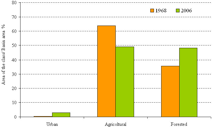
The surface of the Coscile basin in the period 1957-1968 ([7], [9]), was covered by forests (30% natural forest areas and 1% reforested areas) and severely degraded areas (5%); agricultural areas were about 64% of the surface of the basin, out of which approximately 21% were wooded arable lands, while meadows and pastures covered about 15% and urbanized areas represented only 0.5%.
The woodiness index, as derived from the CLC ([13]), is approximately 38%, including natural forests (26%) and reforested areas (12%); highly degraded forest areas concerned about 10%. The agricultural areas were 49% of the whole surface, including natural grassland (8%); urbanized areas represent only 3% of the total surface (Fig. 3).
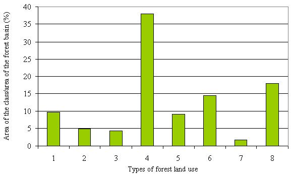
As from CLC ([13]), the physiognomic types are mainly beech forests, beech forest with reforestation of Black pine, and reforestation of Black and Mediterranean pine (class 4, 8, and 6 in Fig. 4, respectively). In the higher areas, reforestation of Black pine was sometimes replanted within beech forests, where extensive cut was done in the past.
Fig. 4 - Forest land use ([13]). The different physiognomic types are: (1) Forests dominated by Holm oak with scattered throughout groups of Cork oak; (2) Pure and mixed forests dominated by deciduous oaks; (3) Mesophilous hardwood forests; (4) Beech forests; (5) Forests with prevalence of hydrophytes; (6) Reforestation of Black pine and Mediterranean pine; (7) Mixed forests of conifers and broadleaves, with a prevalence of other native broadleaves; (8) Beech forests and reforestation of Black pine.
The comparison between the two periods shows a significant increase of urbanized areas (about 685 ha), a decrease of agricultural areas (15%) and an increase of the total forest area (12%), out of which 11% due to reforestation. On the other hand, very degraded forest areas were slightly increasing (5%).
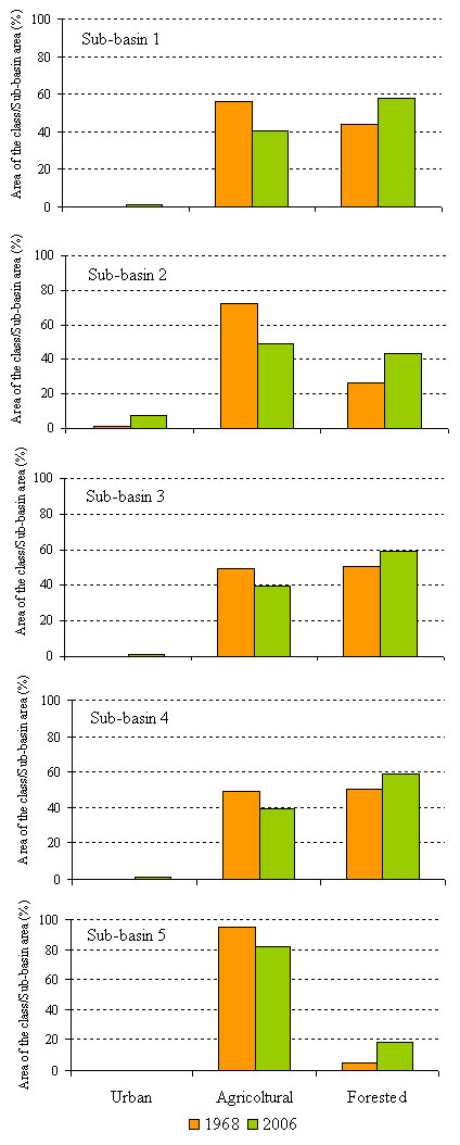
Land use dynamic is confirmed at sub-basin scale reproducing a similar trend as to the entire basin (Fig. 5).
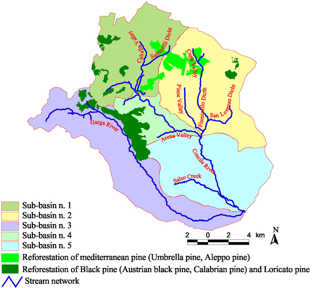
The increase of areas affected by reforestation was over 3 000 hectares. Indeed, the comparison of natural grassland and pasture areas and the analysis of technical documents relating to these projects in the two periods indicate that 65% of reforested areas includes lands that had previously supported these uses. The pine reforestation, particularly Austrian black pine, Calabrian pine and in part Loricate pine (Pinus leucodermis Antonie), was carried out since 1957 up to 1960, while Mediterranean pine reforestation - Umbrella and Aleppo pine - was carried out in 1959 and 1960. Most of the Umbrella and Aleppo pine reforestation cover the slopes of the Vallone Fiumicello, on the left side of the Coscile River. The area reforested with these species covers about 825 hectares and 80% of this area is concentrated in a single large area of the Valle Piane sub-basin.
The planting technique included soil preparation work on terraced hill slopes 4-5 meters apart (depending on the slope), each terrace 80 cm wide. As regards the direct seeding along the terraces, 10-15 and 90-100 kg ha-1 of seeds was used for Aleppo and Umbrella pine, respectively. Thus, the initial densities were particularly high: in the Umbrella pine stands 6 years after sowing about 12 000 up to more than 21 000 plants ha-1 were still surviving; while for the Aleppo pine stands 48 000 to 96 000 plants ha-1 were detected ([11]). Early on, density was reduced by thinning and, in later years, with moderate thinning. Also, self-thinning took place in several areas, so that in the early 1980s the above stands approached current density values, ranging from 1 400 to 1 900 trees ha-1, still quite high in relation to the stand age.
Austrian black pine had been used in reforestation in the range 800-900 m a.s.l. up to 1300-1500 m; Calabrian pine has been used where substrate conditions were suitable; on limited areas with well-preserved soils, Atlas cedar and Douglas fir were also used. These reforestation activities currently cover large areas of the middle and upper basin of the Garga River and other smaller streams, all right tributaries of the Coscile River, as well as the very steep slopes of the hydrographic left side of the Vallone Fiumicello basin. The total reforested area is 2125 ha and is mainly concentrated in one large area on the crest of the Coscile and Garga River, with areas of smaller size spread in the other sub-basins (Fig. 6).
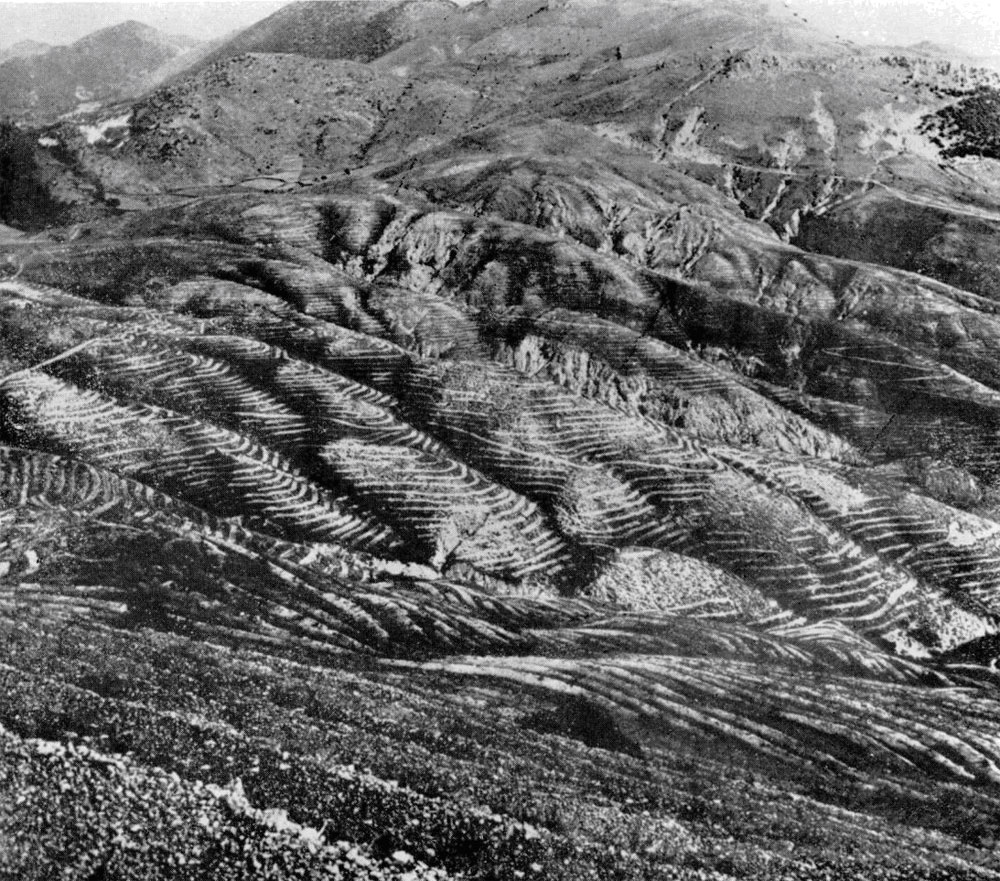
The most widely used soil preparation technique has been terraced hillslopes along the contour lines; following the slope, in some areas the distance between terraces was 4-5 m. Within two terraces, segments of terraces 2 m long and 3 m distant from each other were made. Each terrace was 40-80 cm wide with a 20% upstream counter slope. On average, each hectare was involved with about 2800-3300 m of terraces and segments of terraces; the plants along the terrace were spaced about 70-80 cm apart (Fig. 7).
Fig. 7 - Soil preparation work for terraced hillslopes of Coscile basin (by [8]).
On average, the initial density was 2500-3000 plants ha-1, decreased to about 2000 plants ha-1 in the early ’80s. Current density varies between 1000-1500 plants ha-1, up to 1700 plants ha-1 where thinning operations were ineffective and losses from self-thinning were negligible.
Hydrological analysis
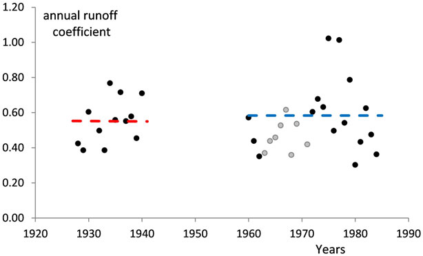
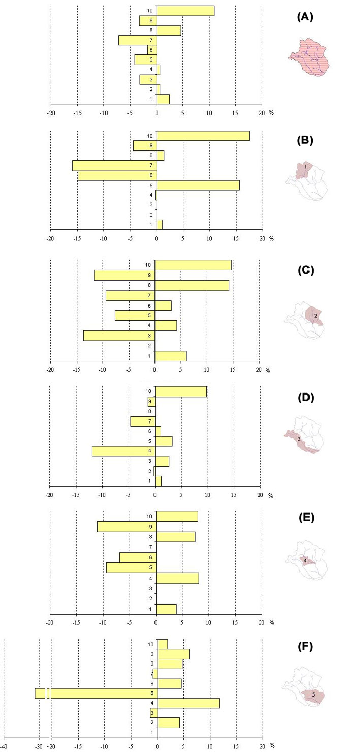
As regards the analysis of the hydrological data, the temporal distribution of the annual values of rainfall and runoff for the Coscile basin at Camerata gauge is shown in Fig. 8. The behavior of annual runoff coefficients (Fig. 9) reveals similar mean values for the periods considered (Tab. 2), both before and after reforestation. Analogously, CN parameter estimated for the whole basin in the two time spans considered did not show any substantial differences, being its value about 54 before and after land use changes (Tab. 3). These values can probably be due to the opposing effects caused by the substantial increase in reforested area (11%) which was counterbalanced by the increase of both degraded wooded areas and urbanized areas, as well as the decrease of extent of forestland (Fig. 10a). The disaggregated analysis of the CN value for each sub-basin (Tab. 3) shows an increase in the CN by an average of 4.8 units only in sub-basin 2 from 1968 to 2006. This situation stems from an increase in the surface area of highly degraded forests (+14.3%) and urbanized areas (+6%), although the reforestation account for 14.7% of the area within the sub-basin (1080 ha - Fig. 10c). The only sub-basin in which a marked negative variation of the CN value (5.9) occurs is the sub-basin 5, which is located in the valley, where 81% of the entire sub-basin is committed to agricultural uses. The decrease of 32% of heterogeneous agricultural areas (CN=72) is mitigated by increases in the surfaces of all other land uses, including forests and reforestation accounting for 8% (Fig. 10f).
Fig. 9 - Runoff coefficients for the Coscile basin at Camerata gauge. Dashed red line represents the mean value for period 1924-40, while the dashed blue line represents the mean value for period 1960-84, not considering grey points. For more details, see text.
Tab. 2 - Values of CN parameter related to the different land uses in the Coscile basin.
| Land use | CN | Area - 1968 (ha) |
Area - 2006 (ha) |
|---|---|---|---|
| Urbanized areas | 98 | 135 | 820 |
| Vineyards | 45 | 1283 | 406 |
| Orchards | 45 | 158 | 347 |
| Olive groves | 45 | 3281 | 3452 |
| Heterogeneous agricultural areas (Annual crops associated with permanent crops + Complex cultivation patterns + Agro-forestry areas) |
72 | 5789 | 4636 |
| Arable crops | 72 | 3085 | 2603 |
| Natural grasslands | 50 | 4155 | 2162 |
| Highly degraded forest areas | 77 | 1420 | 2731 |
| Forest | 38 | 8197 | 7295 |
| Reforestation | 35 | 290 | 3340 |
Tab. 3 - Mean values of CN for each sub-basin and the whole basin.
| Sub-basin | Area (ha) |
CN 1968 |
CN 2006 |
CN (1968-2006) |
|---|---|---|---|---|
| 1 | 5781 | 50.9 | 49.9 | -1 |
| 2 | 7361 | 57.1 | 61.9 | 4.8 |
| 3 | 7437 | 48.5 | 49.3 | 0.8 |
| 4 | 2318 | 53.2 | 53.3 | 0.1 |
| 5 | 4895 | 66.1 | 55.2 | -5.9 |
| Whole basin | 27794 | 54.1 | 54.1 | 0 |
Fig. 10 - Change of land use from 1968 to 2006 in Coscile basin and for the different sub-basins of Coscile watershed. (1): urbanized areas; (2): orchards; (3): vineyards; (4): olive groves; (5): heterogeneous agricultural areas; (6): Arable crops; (7): natural grassland; (8): highly degraded forest areas; (9): forest; (10): reforestation.
As for the other three sub-basins the variation of the CN are very small. In sub-basin 1 a slight decrease of the CN has been obtained, due to an substantial increase in reforested area (17.4%), little variation of the very degraded forest areas and urban areas (+1.4% and +1.1%, respectively) and a 16% increase in heterogeneous agricultural areas. Conversely, a strong decrease of both natural grasslands (16%) and arable crops (15%) was detected (Fig. 10b).
In sub-basins 3 and 4 (Fig. 10d, Fig. 10e) no substantial changes of the CN values were detected, although a conspicuous increase in reforested areas was found (10% and 8%, respectively). In sub-basin 3, an increase in surface reforested and a concurrent reduction of natural grasslands, olive groves and forests were observed.
In sub-basin 4, increased reforestation is balanced by both the reduction in the forested area and the heterogeneous agricultural areas, besides the increase in highly degraded forest areas and urbanized areas.
Discussion
The link between waters and forests are yet a subject of discussion ([1], [14]). Sun et al. ([27]), using small experimental reference basins, highlight how reforestation efforts result in a reduced runoff coefficient. This reduction may also depend on the type of species used. Farley et al. ([15]) compared the effect of both eucalyptus and pine reforestation, where a runoff reduction by 75% and 40% has been observed, respectively. In this case, the authors attributed the recorded differences to the different growth patterns of the species used. Analogous studies on larger basins (with areas of about 1000 km2) show how the degree of reduction strongly depends on reforestation characteristics and specific hydrological conditions ([30]). Buttle ([5]) suggests that reforestation reduces several metrics of peak streamflow at the Ganaraska River basin, Canada. By analyzing a 267 km2 basin with about 12% of the basin forested with pine and red oak, the author detected a decrease in annual runoff of about 100 mm, a decrease of peak daily flow and an increase in annual minimum flow.
In this study, the effects of reforestation on runoff reduction are not obvious, though they can be masked by various causes: the concurrently increased urbanized areas, the relatively large size of the basin, the limited extent of reforested area and the uncomplete development and evolution of the reforested stands. In fact, plantations have likely increased the soil infiltration rate and the evapo transpiration losses in Coscile basin, though the runoff decrease was partially counterbalanced by an increase in runoff from very degraded lands and urbanized areas. Moreover, the effects of reforestation can be considered as opposed to those due the forest destruction, but are more gradual and not immediately recognizable. In a first phase the techniques of preparation of the soil, including terracing, affect the water balance and soil erosion. Subsequently, plant growth provides soil protection as canopy cover approaches to full closure, and finally a gradual improvement of soil physical and chemical properties (including hydrological features) takes place, as organic matter accelerates the renaturation processes ([16]). Indeed, the reforestation carried out in the ’50 in the Coscile Basin are currently in a stage of soil improvement, with renaturalization processes occurring only in part, due to the high stand density.
Conclusions
A historical analysis on land use changes, with particular reference to reforestation following decades of abandonment and exploitation, has been performed in a large basin (277 km2) of southern Italy characterized by intense degradation on very steep slopes. In the scientific literature, studies on reforested basins are fewer than those devoted to deforested basins, since the effects of deforestation are more rapidly appreciable than those due to the reforestation.
The investigation carried out in the Coscile basin suffered the above difficulty in detecting the effects of reforestation on the hydrological behaviour of a large basin. In fact, a 11% spatial increase of reforested areas in a basin of 277 km2 has not modified runoff coefficient and CN parameter, the latter evaluated both at a sub-basin and basin scale. Our results could be the consequence of a trade-off between increases of reforested areas, degraded areas urbanized areas. It is worth to be noticed that these results depends on characteristics of the specific reforested area, in that the time periods analyzed refers to the monospecific pine reforestation experiencing only variations in density in relation to age. However, in future the hydrological response may change as a result of the increased structural complexity of reforestation, according to an evolutionary dynamics that can be supported through forest management.
Notes
The authors contributed to this paper in equal measure.
References
Gscholar
Gscholar
Gscholar
Gscholar
Gscholar
Gscholar
Gscholar
Gscholar
Gscholar
Gscholar
Gscholar
Gscholar
Gscholar
Gscholar
CrossRef | Gscholar
Gscholar
Gscholar
Gscholar
Authors’ Info
Authors’ Affiliation
E Ferrari
F Iovino
A Nicolaci
A Veltri
Department of Soil Protection, University of Calabria, Rende (CS - Italy)
Institute for Agricultural and Forest Systems in the Mediterranean, National Research Council, v. Cavour 4-6, I-87036 Rende (CS - Italy)
Corresponding author
Paper Info
Citation
D’Ippolito A, Ferrari E, Iovino F, Nicolaci A, Veltri A (2013). Reforestation and land use change in a drainage basin of southern Italy. iForest 6: 175-182. - doi: 10.3832/ifor0741-006
Academic Editor
Agostino Ferrara
Paper history
Received: Aug 18, 2012
Accepted: Jan 31, 2013
First online: May 08, 2013
Publication Date: Aug 01, 2013
Publication Time: 3.23 months
Copyright Information
© SISEF - The Italian Society of Silviculture and Forest Ecology 2013
Open Access
This article is distributed under the terms of the Creative Commons Attribution-Non Commercial 4.0 International (https://creativecommons.org/licenses/by-nc/4.0/), which permits unrestricted use, distribution, and reproduction in any medium, provided you give appropriate credit to the original author(s) and the source, provide a link to the Creative Commons license, and indicate if changes were made.
Web Metrics
Breakdown by View Type
Article Usage
Total Article Views: 57539
(from publication date up to now)
Breakdown by View Type
HTML Page Views: 47687
Abstract Page Views: 3648
PDF Downloads: 4426
Citation/Reference Downloads: 125
XML Downloads: 1653
Web Metrics
Days since publication: 4664
Overall contacts: 57539
Avg. contacts per week: 86.36
Article Citations
Article citations are based on data periodically collected from the Clarivate Web of Science web site
(last update: Mar 2025)
Total number of cites (since 2013): 19
Average cites per year: 1.46
Publication Metrics
by Dimensions ©
Articles citing this article
List of the papers citing this article based on CrossRef Cited-by.
Related Contents
iForest Similar Articles
Research Articles
Role of forest cover, land use change and climate change on water resources in Marmara basin of Turkey
vol. 8, pp. 480-486 (online: 31 October 2014)
Research Articles
Slope shape effect on runoff and soil erosion under natural rainfall conditions
vol. 7, pp. 110-114 (online: 18 December 2013)
Review Papers
Large-scale effects of forest management in Mediterranean landscapes of Europe
vol. 6, pp. 342-346 (online: 29 August 2013)
Research Articles
Web GIS-based simulation of water fluxes in the Miyun catchment area
vol. 7, pp. 363-371 (online: 19 May 2014)
Research Articles
Scale dependency of the effects of landscape structure and stand age on species richness and aboveground biomass of tropical dry forests
vol. 16, pp. 234-242 (online: 23 August 2023)
Technical Reports
The treatment of land use, land use change and forestry in the post-2012 climate agreement: a perspective from non-Annex I Parties
vol. 3, pp. 56-58 (online: 17 May 2010)
Short Communications
The Polish landscape changing due to forest policy and forest management
vol. 2, pp. 140-142 (online: 30 July 2009)
Review Papers
Soil fungal communities across land use types
vol. 13, pp. 548-558 (online: 23 November 2020)
Research Articles
An overview of Italian participation in afforestation and reforestation projects under the Clean Development Mechanism
vol. 9, pp. 720-728 (online: 17 May 2016)
Research Articles
Quantitative assessment of past and future tropical forest transition and its dynamic to streamflow of the catchment, Malaysia
vol. 17, pp. 181-191 (online: 30 June 2024)
iForest Database Search
Search By Author
Search By Keyword
Google Scholar Search
Citing Articles
Search By Author
Search By Keywords
PubMed Search
Search By Author
Search By Keyword

