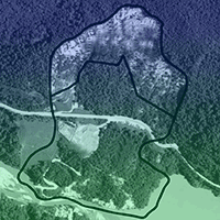
Forests are increasingly valued for services beyond timber and non-timber products including land protection with respect to events such as landslides, soil erosion, floods and avalanches. The most important properties of a protective forest are its ecological and mechanical stability. Planning and implementing multifunctional forest management in protective forests is challenging because of the trade-offs and synergies among the many functions of the forest. In this study, a multifactor empirical method is presented for assessing the protective role of forests on a stand scale with respect to landslide occurrence. Multifactor methodologies typically estimate landslide susceptibility exploiting the relationship between past landslide patterns and site characteristics. Two statistical approaches were here applied to assess the probability of landslide occurrence: the weight-of-evidence technique and the logistic regression technique. Statistical analysis was performed on the basis of landslide detachment zone only. The question of how to estimate protective forest function was answered through the comparison of models established with different sets of predicting factors. This study ultimately aims to provide a decision-support tool focused on mapping the potential role of forests in landslide-prone areas. A case study from the Italian Alps was considered. The density of landslide detachment outside forest areas proves to be more than twice than that within forest areas.
Keywords
, , , , ,
Citation
Cimini D, Portoghesi L, Madonna S, Grimaldi S, Corona P (2016). Multifactor empirical mapping of the protective function of forests against landslide occurrence: statistical approaches and a case study. iForest 9: 383-393. - doi: 10.3832/ifor1740-008
Academic Editor
Marco Borghetti
Paper history
Received: May 28, 2015
Accepted: Oct 20, 2015
First online: Jan 16, 2016
Publication Date: Jun 01, 2016
Publication Time: 2.93 months
© SISEF - The Italian Society of Silviculture and Forest Ecology 2016
Open Access
This article is distributed under the terms of the Creative Commons Attribution-Non Commercial 4.0 International (https://creativecommons.org/licenses/by-nc/4.0/), which permits unrestricted use, distribution, and reproduction in any medium, provided you give appropriate credit to the original author(s) and the source, provide a link to the Creative Commons license, and indicate if changes were made.

Breakdown by View Type
(Waiting for server response...)
Article Usage
Total Article Views: 51264
(from publication date up to now)
Breakdown by View Type
HTML Page Views: 42623
Abstract Page Views: 3416
PDF Downloads: 4053
Citation/Reference Downloads: 22
XML Downloads: 1150
Web Metrics
Days since publication: 3815
Overall contacts: 51264
Avg. contacts per week: 94.06
Article Citations
Article citations are based on data periodically collected from the Clarivate Web of Science web site
(last update: Mar 2025)
Total number of cites (since 2016): 10
Average cites per year: 1.00
Publication Metrics
by Dimensions ©
Articles citing this article
List of the papers citing this article based on CrossRef Cited-by.
(1)
Ammann M, Boll A, Rickli C, Speck T, Holdenrieder O (2009)Significance of tree root decomposition for shallow landslide. Forest, Snow and Landscape Research 82 (1): 79-94.
Online |
Gscholar
(2)
Anbalagan R, Sing B (1996)Landslide hazard and risk assessment mapping in mountainous terrains - cases study from Kumaun Hymalaya, India. Engineering Geology 43: 237-246.
CrossRef |
Gscholar
(3)
ARPAV (2005)Carta dei suoli del Veneto in scala 1:250.000 [Soil Map of Veneto 1:250.000]. Regional Agency for Environmental Protection and Prevention of the Veneto, Regional Observatory on Soil, Veneto Region, Padua, Italy.
Gscholar
(4)
Ayalew L, Yamagishi H (2005)The application of GIS-based logistic regression for landslide susceptibility mapping in the Kakuda-Yahiko Mountains, Central Japan. Geomorphology 65: 15-31.
CrossRef |
Gscholar
(5)
Ayalew L, Yamagishi H, Ugawa N (2004)Landslide susceptibility mapping using GIS-based weighted linear combination, the case in Tsugawa area of Agano River, Niigata Prefecture, Japan. Landslides 1 (1): 73 82.
CrossRef |
Gscholar
(6)
Barbieri G, Cambuli P (2009)The weight of evidence statistical method in landslide susceptibility mapping of the Rio Pardu Valley (Sardinia, Italy). In: Proceedings of the “18th World IMACS Congress and MODSIM09 International Congress on Modelling and Simulation” (Anderssen RS, Braddock RD, Newham LTH eds). The Modelling and Simulation Society of Australia and New Zealand Inc. and the International Association for Mathematics and Computers in Simulation. Nedlands, Western Australia, pp. 2659-2664.
Online |
Gscholar
(7)
Bebi P, Kienast F, Schönenberger W (2001)Assessing structures in mountain forests as a basis for investigating the forests’ dynamics and protective function. Forest Ecology and Management 145: 3-14.
CrossRef |
Gscholar
(8)
Beguería S (2006)Validation and evaluation of predictive models in hazard assessment and risk management. Natural Hazards 37 (3): 315-329.
CrossRef |
Gscholar
(9)
Berger F, Rey F (2004)Mountain protection forests against natural hazards and risks: new French developments by integrating forests in risk zoning. Natural Hazards 33: 395-404.
CrossRef |
Gscholar
(10)
Bijukchhen SM, Kayastha P, Dhita MR (2012)A comparative evaluation of heuristic and bivariate statistical modelling for landslide susceptibility mapping in Ghurmi-Dhad Khola, east Nepal. Arabian Journal of Geosciences 6 (8): 2727-2743.
CrossRef |
Gscholar
(11)
Brang P (2001)Resistance and elasticity: promising concepts for management of protection forests in the European Alps. Forest Ecology and Management 145: 107-119.
CrossRef |
Gscholar
(12)
Brang P, Schönenberger W, Ott E, Gardner B (2001)Forests as protection from natural hazards. In: “The Forests Handbook, vol. 2” (Evans J ed). Blackwell Science, Oxford, UK, pp. 53-81.
Online |
Gscholar
(13)
Bonham-Carter GF, Agterberg FP, Wright DF (1989)Weights of evidence modeling: a new approach to mapping mineral potential. In: “Statistical Applications in the Earth Sciences” (Agterberg, FP, Bonham-Carter GF eds). Paper 89-9, Geological Survey of Canada, Canadian Government Publishing Centre, Ottawa, Canada, pp. 171-183.
Online |
Gscholar
(14)
Brenning A (2005)Spatial prediction models for landslide hazards: review, comparison and evaluation. Natural Hazards and Earth System Science 5: 583-862.
CrossRef |
Gscholar
(15)
Burrough PA, McDonell RA (1998)Principles of geographical information systems. Oxford University Press, New York, USA, pp. 190.
Gscholar
(16)
Carrara A, Cardinali M, Detti R, Guzzetti F, Pasqui V, Reichenbach P (1991)GIS techniques and statistical models in evaluating landslide hazard. Earth Surface Processes and Landforms 16: 427-445.
CrossRef |
Gscholar
(17)
Cervi F, Berti M, Borgatti L, Ronchetti F, Manenti F, Corsini A (2010)Comparing predictive capability of statistical and deterministic methods for landslide susceptibility mapping: a case study in the northern Apennines (Reggio Emilia Province, Italy). Landslides 7 (4): 433-444.
CrossRef |
Gscholar
(18)
Chen H, Wang J (2007)Landslide hazard mapping using logistic regression model in Mackenzie Valley, Canada. Natural Hazards 42: 75-89.
CrossRef |
Gscholar
(19)
Chung CF, Fabbri AG (1999)Probabilistic prediction models for landslide hazard mapping. Photogrammetric Engineering and Remote Sensing 65 (12): 1389-1399.
Online |
Gscholar
(20)
Cimini D, Tomao A, Mattioli W, Barbati A, Corona P (2013)Assessing impact of forest cover change dynamics on high nature value farmland under Mediterranean mountain landscape. Annals of Silvicultural Research 37: 29-37.
Online |
Gscholar
(21)
Claessens L, Schoorl JM, Veldkamp A (2007)Modelling the location of shallow landslides and their effects on landscape dynamics in large watersheds: an application for Northern New Zealand. Geomorphology 87: 16-27.
CrossRef |
Gscholar
(22)
Clark WA, Hosking P (1986)Statistical methods for geographers. John Wiley and Sons, New York, USA, pp. 252.
Gscholar
(23)
Cruden DM, Varnes DJ (1996)Landslides types and processes. In: “Landslides: Investigation and Mitigation” (Turner AK, Schuster RL eds). Special Report 247, Transportation Research Board, National Academy Press, WA, USA, pp. 36-75.
Gscholar
(24)
Cruden DM (1991)A simple definition of a landslide. IAEG Bulletin 43: 27-29.
CrossRef |
Gscholar
(25)
Dal Piaz GV (1988)Carta Geologica del Veneto a scala 1:250.000 [Geological Map of Veneto in scale 1:250.000]. Regional Secretariat for the Territory of the Region of Veneto, Padua University, Institute of Geology, Selca Publishing, Florence, Italy.
Gscholar
(26)
Dai FC, Lee CF, Li J, Xu ZW (2001)Assessment of landslide susceptibility on the natural terrain of Lantau Island, Hong Kong. Environmental Geology 40: 381-391.
CrossRef |
Gscholar
(27)
Domínguez-Cuesta MJ, Jiménez-Sánchez M, Berrezueta E (2007)Landslides in the Central Coalfield (Cantabrian Mountains, NW Spain): geomorphological features, conditioning factors and methodological implications in susceptibility assessment. Geomorphology 89: 358-369.
CrossRef |
Gscholar
(28)
Dorren LKA, Berger F, Imeson AC, Maier B, Rey F (2004)Integrity, stability and management of protection forests in the European Alps. Forest Ecology and Management 195: 165-176.
CrossRef |
Gscholar
(29)
Duman TY, Can T, Gokceoglu C, Nefeslioglu HA, Sonmez H (2006)Application of logistic regression for landslide susceptibility zoning of Cekmece Area, Istanbul, Turkey. Environmental Geology 51: 241-256.
CrossRef |
Gscholar
(30)
ESRI (2009)ArcGIS. Environmental Systems Research Institute, Redlands, CA, USA.
Gscholar
(31)
Frattini P, Crosta G, Carrara A (2010)Techniques for evaluating the performance of landslide susceptibility models. Engineering Geology 111: 62-72.
CrossRef |
Gscholar
(32)
Forbes K, Broadhead J, Bischetti GB, Brardinoni F, Dykes A, Gray D, Imaizumi F, Kuriakose SL, Osman N, Petley D, Stokes A, Verbist B, Wu TH (2013)Forests and landslides: the role of trees and forests in the prevention of landslides and rehabilitation of landslide-affected areas in Asia. Food and Agriculture Organization of the United Nations, Regional Office for Asia and the Pacific, Bangkok, Thailand, pp. 42.
Online |
Gscholar
(33)
Glade T (2003)Landslide occurrence as a response to land use change: a review of evidence from New Zealand. Catena 51: 297-314.
CrossRef |
Gscholar
(34)
Graf F, Frei M, Böll A (2009)Effects of vegetation on the angle of internal friction of a moraine. Forest Snow Landscape Research 82 (1): 61-77.
Online |
Gscholar
(35)
Gorsevski PV, Gessler PE, Foltz RB, Elliot WJ (2006)Spatial prediction of landslide hazard using Logistic Regression and ROC analysis. Transactions in GIS 10 (3): 395-415.
CrossRef |
Gscholar
(36)
Grêt-Regamey A, Walz A, Bebi P (2008)Valuing ecosystem services for sustainable landscape planning in Alpine regions. Mountain Research and Development 28: 156-165.
CrossRef |
Gscholar
(37)
Guzzetti F, Carrara A, Cardinali M, Reichenbach P (1999)Landslide hazard evaluation: a review of current techniques and their application in a multi-scale study, Central Italy. Geomorphology 31: 181-216.
CrossRef |
Gscholar
(38)
Komac M (2006)A landslide susceptibility model using the Analytical Hierarchy Process method and multivariate statistics in perialpine Slovenia. Geomorphology 74: 17-28.
CrossRef |
Gscholar
(39)
Hosmer DW, Lemeshow S (1989)Applied logistic regression. John Wiley and Sons, New York, USA, pp. 307.
Gscholar
(40)
Hutchinson MF (1989)A new procedure for gridding elevation and stream line data with automatic removal of spurious pits. Journal of Hydrology 106: 211-232.
CrossRef |
Gscholar
(41)
ISPRA (2008)Landslides in Italy. Italian National Institute For Environmental Protection and Research, Special report 2008, 83/2008 (Trigila A, Iadanza C eds), CSR, Rome, Italy, pp. 38.
Gscholar
(42)
Lanni C, Borga M, Rigon R, Tarolli P (2012)Modelling shallow landslide susceptibility by means of a subsurface flow path connectivity index and estimates of soil depth spatial distribution. Hydrology and Earth System Sciences 16: 3959-3971.
CrossRef |
Gscholar
(43)
Lee S, Choi J, Min K (2004a)Probabilistic landslide hazard mapping using GIS and remote sensing data at Boun, Korea. International Journal of Remote Sensing 25 (11): 2037-2052.
CrossRef |
Gscholar
(44)
Lee S, Choi J, Woo I (2004b)The effect of spatial resolution on the accuracy of landslide susceptibility mapping: a case study in Boun, Korea. Geosciences Journal 8: 51-60.
CrossRef |
Gscholar
(45)
Lee S, Talib JA (2005)Probabilistic landslide susceptibility and factor effect analysis. Environmental Geology 47: 982-990.
CrossRef |
Gscholar
(46)
Lee S, Sambath T (2006)Landslide susceptibility mapping in the Damrei Romel area, Cambodia, using frequency ratio and logistic regression models. Environmental Geology 50: 847-855.
CrossRef |
Gscholar
(47)
Magliuolo P, Agliulo P, Lisio AD, Russo F, Zelano A (2008)Geomorphology and landslide susceptibility assessment using GIS and bivariate statistics: a case study in southern Italy. Natural Hazards 47: 411-435.
CrossRef |
Gscholar
(48)
Marston RA (2010)Geomorphology and vegetation on hillslopes: interactions, dependencies, and feedback loops. Geomorphology 116 (3-4): 206-217.
CrossRef |
Gscholar
(49)
Menard S (2000)Coefficients of determination for multiple logistic regression analysis. American Statistician 54: 17-24.
CrossRef |
Gscholar
(50)
Montgomery DR, Dietrich WE (1994)A physically based model for the topographic control on shallow landsliding. Water Resources Research 30: 1153-1171.
CrossRef |
Gscholar
(51)
Mossa S, Capolongo D, Pennetta L, Wasowski J (2005)A GIS-based assessment of landsliding in the Daunia Apennines, Southern Italy. Polish Geological Institute Special Papers 20: 86-91.
Online |
Gscholar
(52)
Moon V, Blackstock H (2004)Methodology for assesing landslide hazard using deterministic stability models. Natural Hazards 32 (1): 111-134.
CrossRef |
Gscholar
(53)
Motta R, Haudemand JC (2000)Protective forests and silvicultural stability: an example of planning in the Aosta Valley. Mountain Research and Development 20 (2): 180-187.
CrossRef |
Gscholar
(54)
Motta R, Lingua E (2005)Human impact on size, age, and spatial structure in a mixed European larch and Swiss stone pine forest in the Western Italian Alps. Canadian Journal of Research 35: 1809-1820.
CrossRef |
Gscholar
(55)
Nefeslioglu HA, Gokceoglu C, Sonmez H (2008)An assessment on the use of logistic regression and artificial neural networks with different sampling strategies for the preparation of landslide susceptibility maps. Engineering Geology 97: 171-191.
CrossRef |
Gscholar
(56)
Notaro S, Paletto A (2011)Links between mountain communities and environmental services in the Italian Alps. Sociologia Ruralis 5: 137-157.
CrossRef |
Gscholar
(57)
Ohlmacher CG, Davis CJ (2003)Using multiple regression and GIS technology to predict landslide hazard in northeast Kansas, USA. Engineering Geology 69: 331-343.
CrossRef |
Gscholar
(58)
Pereira S, Zêzere J, Bateira C (2012)Technical note: assessing predictive capacity and conditional independence of landslide predisposing factors for shallow landslides susceptibility models. Natural Hazards and Earth System Sciences 12: 979-988.
CrossRef |
Gscholar
(59)
Pradhan B, Oh JJ, Buchroithner MF (2010)Weight-of-evidence model applied to landslide susceptibility mapping in a tropical hilly area. Geomatics Natural Hazards and Risk 1 (3): 199-223.
CrossRef |
Gscholar
(60)
R Core Team (2012)R: a language and environment for statistical computing. R Foundation for Statistical Computing, Vienna, Austria.
Online |
Gscholar
(61)
Ramani SE, Pitchaimani K, Gnanamanickam VR (2011)GIS based landslide susceptibility mapping of Tevankarai Ar sub-watershed, Kodaikkanal, India using binary logistic regression analysis. Journal of Mountain Science 8 (4): 505-517.
CrossRef |
Gscholar
(62)
Regmi NR, Giardino JR, Vitek JD (2010)Modelling susceptibility to landslides using the weight of evidence approach: Western Colorado, USA. Geomorphology 115 (1-2): 172-187.
CrossRef |
Gscholar
(63)
Rezaei Moghaddam MH, Khayyam M, Ahmadi M, Farajzadeh M (2007)Mapping susceptibility landslide by using the weight-of-evidence model: a case study in Merek Valley, Iran. Journal of Applied Science 7 (22): 3342-335.
CrossRef |
Gscholar
(64)
Safaei M, Omar H, Huat BK (2011)Deterministic rainfall induced landslide approaches, advantage and limitation. Electronic Journal of Geotechnical Engineering 16: 1619-1650.
Online |
Gscholar
(65)
Sarkar S, Kanungo DP, Patra AK, Pushpendra K (2008)GIS based spatial data analysis for landslide susceptibility mapping. Journal of Mountain Science 5: 52-62.
CrossRef |
Gscholar
(66)
Sawatzky DL, Raines GL, Bonham-Carter GF, Looney CG (2008)Spatial Data Modeller (SDM): ArcMAP 9.2 geoprocessing tools for spatial data modeling using weights of evidence, logistic regression, fuzzy logic and neural networks. ESRI support, web site.
Online |
Gscholar
(67)
Schmidt KM, Roering JJ, Stock JD, Dietrich WE, Montgomery DR, Schaub T (2001)Root cohesion variability and shallow landslide susceptibility in the Oregon Coast Range. Canadian Geotechnical Journal 38: 995-1024.
CrossRef |
Gscholar
(68)
Sidle RC, Pearce AJ, O’Loughlin CL (1985)Hillslope stability and land use. Water Resources Monograph, vol. 11, American Geophysical Union, Washington, DC, USA, pp. 140.
Online |
Gscholar
(69)
Sidle RC, Ochiai H (2006)Landslides: processes, prediction, and land use. Water Resources Monograph, vol. 18. American Geophysical Union, Washington, DC, USA, pp. 312.
Gscholar
(70)
Soeters R, Van Westen CJ (1996)Slope stability: recognition, analysis and zonation. In: “Landslides: investigation and mitigation” (Turner AK, Schuster RL eds). Transportation Research Board - National Research Council, Special Report 247: 129-177.
Gscholar
(71)
Sterlacchini S, Ballabio C, Blahut J, Masetti M, Sorichetta A (2011)Spatial agreement of predicted patterns in landslide susceptibility maps. Geomorphology 125 (1): 51-61.
CrossRef |
Gscholar
(72)
Süzen ML, Doyuran V (2004)A comparison of the GIS based landslide susceptibility assessment methods: multivariate versus bivariate. Environmental Geology 45: 665-679.
CrossRef |
Gscholar
(73)
Tarolli P, Borga M, Chang KT, Chiang SH (2011)Modeling shallow landsliding susceptibility by incorporating heavy rainfall statistical properties. Geomorphology 133: 199-211.
CrossRef |
Gscholar
(74)
Van Den Eeckhaut M, Reichenbach P, Guzzetti F, Rossi M, Poesen J (2009)Combined landslide inventory and susceptibility assessment based on different mapping units: an example from the Flemish Ardennes, Belgium. Natural Hazards and Earth System Sciences 9 (2): 507-521.
CrossRef |
Gscholar
(75)
Varnes DJ (1984)Landslide hazard zonation: a review of principles and practice. Natural Hazard Series 3, UNESCO, Paris, France, pp. 63.
Gscholar
(76)
Vorpahl P, Elsenbeera H, Märkerb M, Schröder B (2012)How can statistical models help to determine driving factors of landslides? Ecological Modeling 239: 27-39.
CrossRef |
Gscholar
(77)
Wati SE, Hastuti T, Wijojo S, Pinem F (2010)Landslide susceptibility mapping with heuristic approach in mountainous area. A case study in Tawangmangu sub District, Central Java, Indonesia. International Achieves of the Photogrammetry, Remote Sensing and Spatial Information Science 38: 248-253.
Online |
Gscholar
(78)
Yesilnacar E, Topal T (2005)Landslide susceptibility mapping: a comparison of logistic regression and neural network methods in a medium scale study, Hendek region (Turkey). Engineering Geology 79: 251-266.
CrossRef |
Gscholar