Fire occurrence zoning from local to global scale in the European Mediterranean basin: implications for multi-scale fire management and policy
iForest - Biogeosciences and Forestry, Volume 9, Issue 2, Pages 195-204 (2015)
doi: https://doi.org/10.3832/ifor1513-008
Published: Nov 12, 2015 - Copyright © 2015 SISEF
Research Articles
Abstract
This study proposes and evaluates a relatively new concept for fire occurrence zoning based on documented historical fire records. The proposed method creates continuous kernel density surfaces based on wildland fire ignition observations. Kernels have the advantage of directly producing density estimates that are not influenced by grid size or localization effects. Within this scheme, kernel density surfaces have been created and reclassified to construct fire occurrence zones at local to global scales in the Mediterranean Basin. Specifically, fire occurrence zones were created for the European scale (European Mediterranean Basin), national scale (Greece), regional scale (Peloponnese, Greece) and local scale (Chalkidiki, Greece). To evaluate fire occurrence zones, we compared the observed with the expected distribution of the number of fires within these zones using a Monte Carlo randomization test, finding that these numbers were statistically different in all cases. The deviations observed from the expected distributions towards the high occurrence zone indicated their successful assessment and value. In this paper, we further discuss their potential role and use for multi-scale fire management and policy in a European context.
Keywords
Fire Occurrence Zones, Kernel Density Interpolation, Local Scale, Regional Scale, National Scale, European Scale, Greece
Introduction
Recent studies on forest fires in the Mediterranean Basin report a shift in fire frequency and area burned, an extension of the fire season, and indications of the association of increased fire activity with short-term climate oscillations ([24]) and/or climate change ([47], [46], [45], [53], [33], [71]), exposed in various sources of uncertainty though ([8]). Wildland fires can result in significant economic and environmental damages, degradation of ecosystem functions and services such as carbon storage, biodiversity preservation, water production and soil protection. In addition, modification of ecosystem succession due to fires can trigger land cover (land use) and landscape change ([67]). The magnitude of the problem of wildland fires, observed even in biomes like those characterizing the Mediterranean Basin, of which historically forest fires have been an integral part, raises the urgent need to develop and implement fire management strategies including effective fire prevention policies. Long-term fire danger evaluation based on robust methods is a critical component of fire prevention policies and strategies ([15], [50]).
The most common approach to model fire ignition patterns and designate high fire risk areas is based on the identification of environmental and socioeconomic geospatial variables that capture historical fire occurrence patterns and explain their underlying causal factors, which afterwards are assimilated into a spatially explicit “structural” or “static” index. Geospatial data layers such as fuel load, topography, road density, population, employment rates etc., are assembled in a database and integrated into a Geographic Information System (GIS) as potential factors explaining historical fire occurrence ([4], [61]).
Methodologies to identify proper parameters and models include qualitative rules for assigning risk values to different variables ([12]), generalized global linear models such as linear regression ([12], [67]) and logit probabilistic models ([27], [79]), machine-learning algorithms ([13], [7], [60]), Classification and Regression Trees (CART - [3]), fuzzy logic ([11]), as well as other advanced statistical methods such as Geographically Weighted Regression (GWR - [31], [38], [50], [61]), which allows the analysis of spatially varying relationships. Most of these approaches, however, are applied at local or regional scales, due to limitations and constraints found when gathering and updating the required geospatial data. In addition, since the relationships between these factors and fire occurrence can vary between different ecosystems and across different spatial and temporal scales ([13], [81]), different dominant fire risk drivers are identified depending on the local conditions of each study. Therefore, there are limitations to extrapolate the findings from one region to another or to generalize the results from local to global scales by combining the findings from different studies. Such efforts contain a certain degree of uncertainty due to the different methodologies and data used.
An alternative approach to overcome the limitations and problems arising from the positional inaccuracies or uncertainties of fire ignition points is to adopt administrative districts such as counties or municipalities ([36], [14], [39]) or map tiles ([72]) as the basic spatial processing unit. However, studies based on aggregated data are vulnerable to the Modifiable Areal Unit Problem (MAUP - [51], [5]), since the aggregation scheme used is to some extent arbitrary and modifiable ([25]). Additionally, aggregated statistics may lead to partial information loss ([55]).
Fire occurrence zones can be created by using kernel densities ([80], [5], [66]) in an attempt to overcome the loss of information from aggregation constraints and to address the inherent positional inaccuracies of fire ignition points. The kernel density concept was originally introduced within the framework of fire occurrence by Koutsias et al. ([28], [29]) to overcome the problems arising from the positional uncertainty of historical fire records. Kernel density interpolation has also been applied by Podur et al. ([57]) to analyze the spatial patterns of lightning-caused forest fires in Ontario. Finally, in other studies the approach of kernel density interpolation has been applied as a preliminary step preceding spatial analysis of the causal factors and subsequent fire risk modeling ([18], [3], [79]).
The goal of our study is to evaluate the kernel density estimation in multi-scale (i.e., local to global scale) fire occurrence zoning in the Mediterranean Basin. Specifically, fire occurrence zones are presented and evaluated for the local (Chalkidiki, Greece), regional (Peloponnese, Greece), national (Greece), and European scale (European Mediterranean Basin). The paper focuses on the statistical evaluation of fire occurrence zones at multiple spatial scales and the discussion of their value and use for multi-scale fire management and fire policy.
Materials and ethods
Study areas and wildland fire data
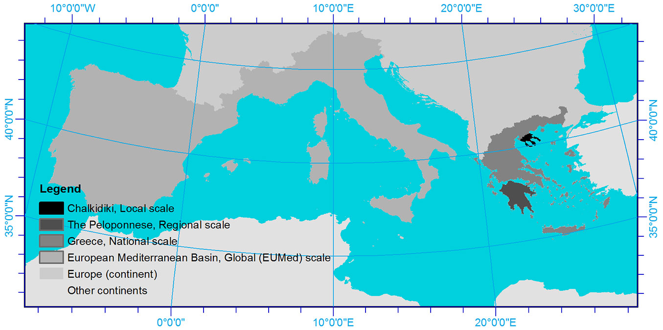
Several study areas were established within the European Mediterranean Basin (Fig. 1) to cover the requirements of the multi-scale approach followed in our study. For each study case different data where used to create and evaluate the kernel density surfaces summarized in Tab. 1. For all Greek study areas the fire database used to create the kernel density surfaces consists of the fire ignition points recorded between 1985 and 1995 in Greece, when a total of 15 206 fire events were registered by the forest authorities. To evaluate the kernel density surfaces on the national level in Greece, we used the fire ignition points of 1996 (one year later than those used to create the kernel density surfaces) when 1320 fire events were registered. For the regional level in the Peloponnese, the 2007 fire perimeters (12 years later than those used to create the kernel density surfaces) were used, provided by the European Forest Fire Information System (EFFIS) of the European Commission Joint Research Centre (JRC). At EUMed scale we used the kernel density surfaces that were created within the EU research project “SPREAD”, using fires that occurred within the period of 1992-2000 and made available using community centroids (number of fires per community), with the exception of Greece where the already mentioned x and y coordinates for 1985-1995 were available and used. To evaluate the kernel density surfaces at EUMed scale we used the fire perimeters of 2000-2010 provided by the JRC. For all cases the evaluation data were either point observations or fire perimeters that occurred in the subsequent years after those used to create the kernel density surfaces, in order to avoid over fitting during the evaluation phase, when the same data are used for both training and evaluation.
Fig. 1 - Several study areas of different magnitudes were established within the European Mediterranean Basin to capture the scale requirements of the multi-scale approach.
Tab. 1 - Data used to create the kernel density surfaces and data used to evaluate the fire occurrence zones for each study case.
| Study area | Source of data used |
Period covered by data |
Number of ignition points used |
Evaluation data |
|---|---|---|---|---|
| Local (Chalkidiki) |
Greek National Forest fire database | 1985 to 1995 | 218 | 1996 and 1997 fire events (29 events) |
| Regional (the Peloponnese) | Greek National Forest fire database | 1985 to 1995 | 2720 | EFFIS (JRC) fire perimeters (year 2007) |
| National (Greece) | Greek National Forest fire database | 1985 to 1995 | 15206 | 1996 fire events (1320 events) |
| Global (EUMed - European Mediterranean Basin) | “SPREAD” database and Greek National Forest Database | 1992-2000/ /1985-1995 |
28 001 community centroids (211 626 fire ignitions points) |
EFFIS (JRC) fire perimeters (years 2000-2010) |
At EUMed scale fire statistics as reported by the five Mediterranean countries (Portugal, Spain, France, Italy and Greece) present some incompatibilities due to different methodologies followed on fire reporting. These different applied methodologies result in a different total number of fires per year (and therefore different fire densities) within each country which cannot be justified from differences in country’s fire regime. A standardization of the density values within each country before merging them was considered to avoid over- or under-estimation within and between the countries, with the disadvantage of the unification of the density values. The main reason underlying such decision was the quite different number of ignition points available for each country that mainly reflects the different methodologies used to report fire ignitions, and not the actual events occurred based on the fire regime of each country.
Methodology
The kernel density approach
For all the study cases the kernel density interpolation was applied keeping the same concept whenever possible, but using different data and scales. The fixed mode approach was adopted when the original fire data were provided in x and y coordinates, in order to keep the smoothing parameter of the kernel constant over the entire study area. In this case the mean nearest distance of fire ignition points was considered to define the size of the bandwidth. When the fire data were aggregated to community centroids the adaptive kernel density interpolation approach was used, as this allows variation of the kernel size according to the concentration of the interpolated points. This enables us to deal with the spatial arrangement of community centroids that is not constant throughout the whole extent of the study area. In some areas the community density is high because the geographic extent of the communities is small, while in others the opposite holds. Therefore, over- or under-estimation of fire occurrence is likely.
The kernel density surfaces were rescaled with the criterion of “equal area” to create four equal area fire occurrence zones for Greece, and five for the EUMed scale.
Evaluation of fire occurrence zones of kernel density surfaces
The expected number of fires occurring under complete spatial randomness would be 25% or 20% in each zone, since each fire occurrence zone corresponds to 1/4 (all Greek study cases) or 1/5 (EUMed scale) of the total area, respectively. Deviations from this expected distribution towards the high occurrence zones indicate a successful assessment of fire occurrence zones. The estimated fire occurrence zones created based on the kernel density surfaces of both the fire ignition points and the control points, were evaluated using the fire perimeters of the year 2007 provided by the JRC, and the fire ignition points that occurred in 1996 in Greece. To statistically compare the results between the different approaches of kernel density interpolation, we applied a Monte Carlo randomization test ([44], [6], [17]), without considering any criteria different from complete randomness using a Microsoft Excel® macro ([56]). The wildfires were randomly reassigned to each class of the geographical layer so that the probability of assignment to each class is equal to the relative extent of that class over the entire area ([6]). Finally, we estimated the resource selection index defined as the ratio of the observed over available to burn ratio. A resource selection index > 1 suggests positive fire selectivity (preference), while an index < 1 suggests negative fire selectivity (avoidance - [37]).
Results
Applying the kernel density approach
Chalkidiki local scale
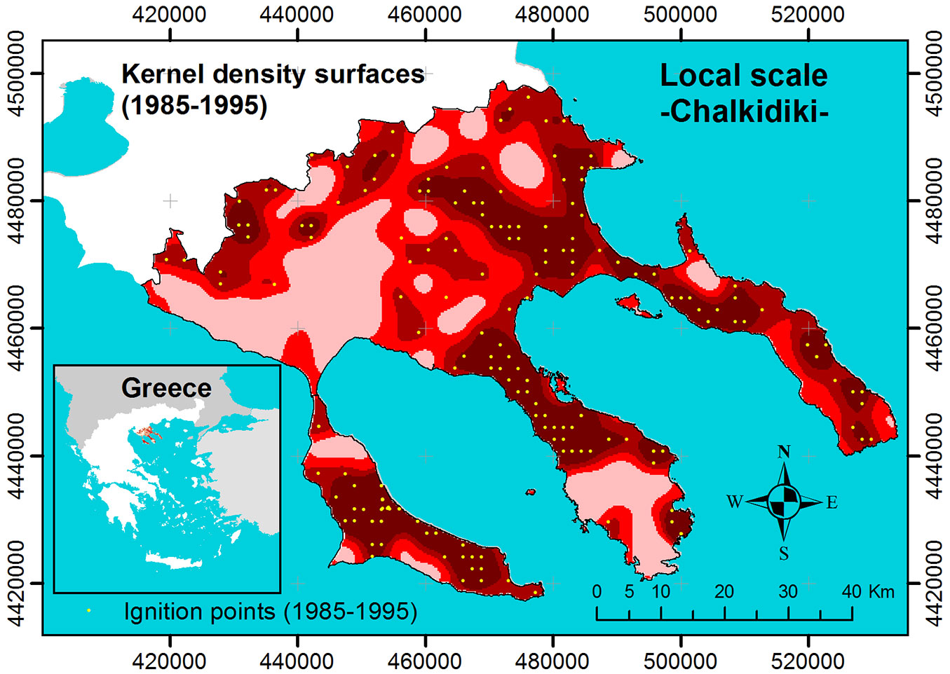
The fire occurrence zones at local scale in Chalkidiki, Greece (Fig. 2), based on the kernel density interpolation, were taken from the study by Koutsias et al. ([29]), where the authors introduced the kernel density concept in wildland fire occurrence and risk mapping. In this study, density surfaces were created and used to delineate zones of fire occurrence at landscape level by smoothing the influence of the individual fire ignition point.
Fig. 2 - Fire occurrence zones based on kernel density surfaces at local scale in Chakidiki, Greece. The yellow dots are the ignition points used in the analysis (see Tab. 1).
The Peloponnese regional scale
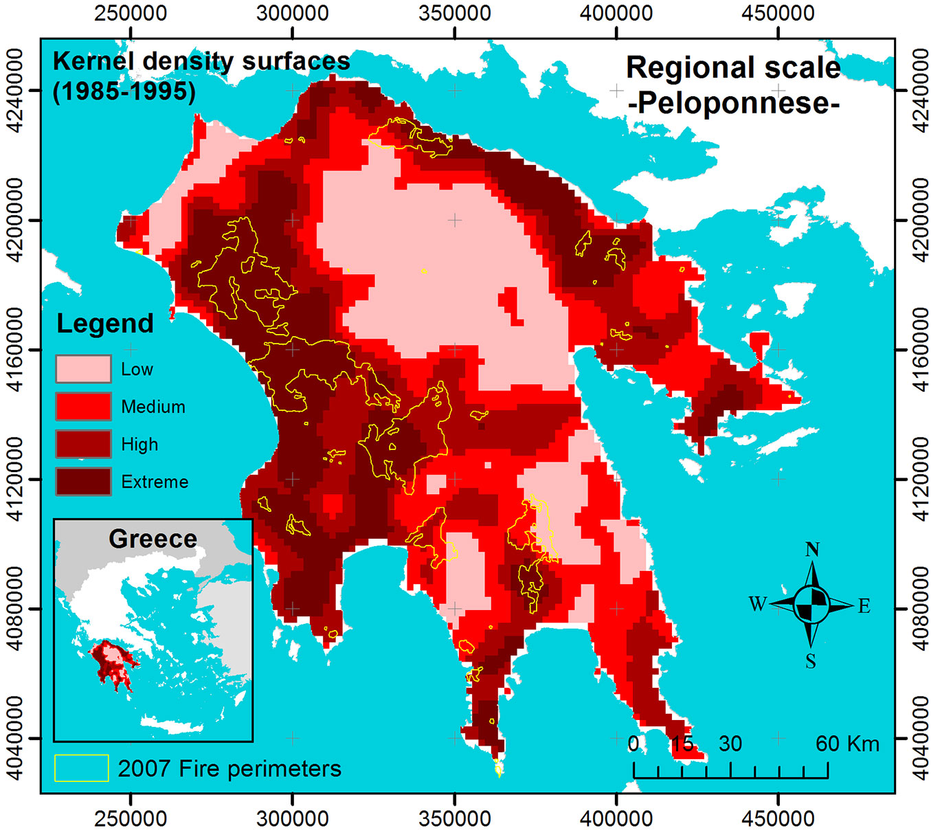
The fire occurrence zones at regional scale in the Peloponnese, Greece (Fig. 3), based on the kernel density interpolation, were taken from the kernel density map of Greece which is the result of the work by Koutsias et al. ([30]) and Koutsias et al. ([34]). The kernel density estimates were rescaled with the criterion of equal area to create four equal area fire occurrence zones within the Peloponnese.
Fig. 3 - Fire occurrence zones based on kernel density surfaces at regional scale in the Peloponnese, Greece.
Greece national scale
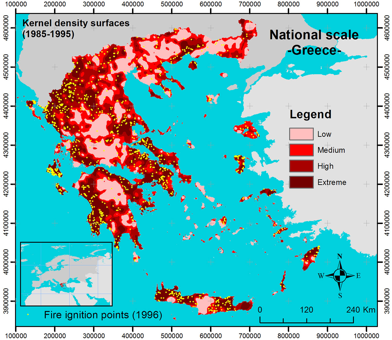
At national scale, the fire occurrence zones (Fig. 4) based on the kernel density interpolation, result from the work of Koutsias et al. ([30]) and Koutsias et al. ([34]). In this study, we applied the kernel density interpolation approach on wildland fire ignition points occurring in Greece from 1985 to 1995. We applied different kernel sizes using the fixed approach, while the kernel size was based on the nearest neighbor distance of the wildland fire ignition points. Apart from the kernel density of fire ignition points, we applied the method to control points created based on different buffer zones established around the fire ignition points. By applying a random sampling scheme excluding certain buffer zones around fire ignition points ([27]), we adopted a sampling scheme to avoid creating control points that would fall on the same or nearby fire ignition points. The buffer zones were chosen based on the mean nearest neighbor distance of fire ignition points.
Fig. 4 - Fire occurrence zones based on kernel density surfaces at national scale in Greece.
European Mediterranean Basin Global EUMed scale
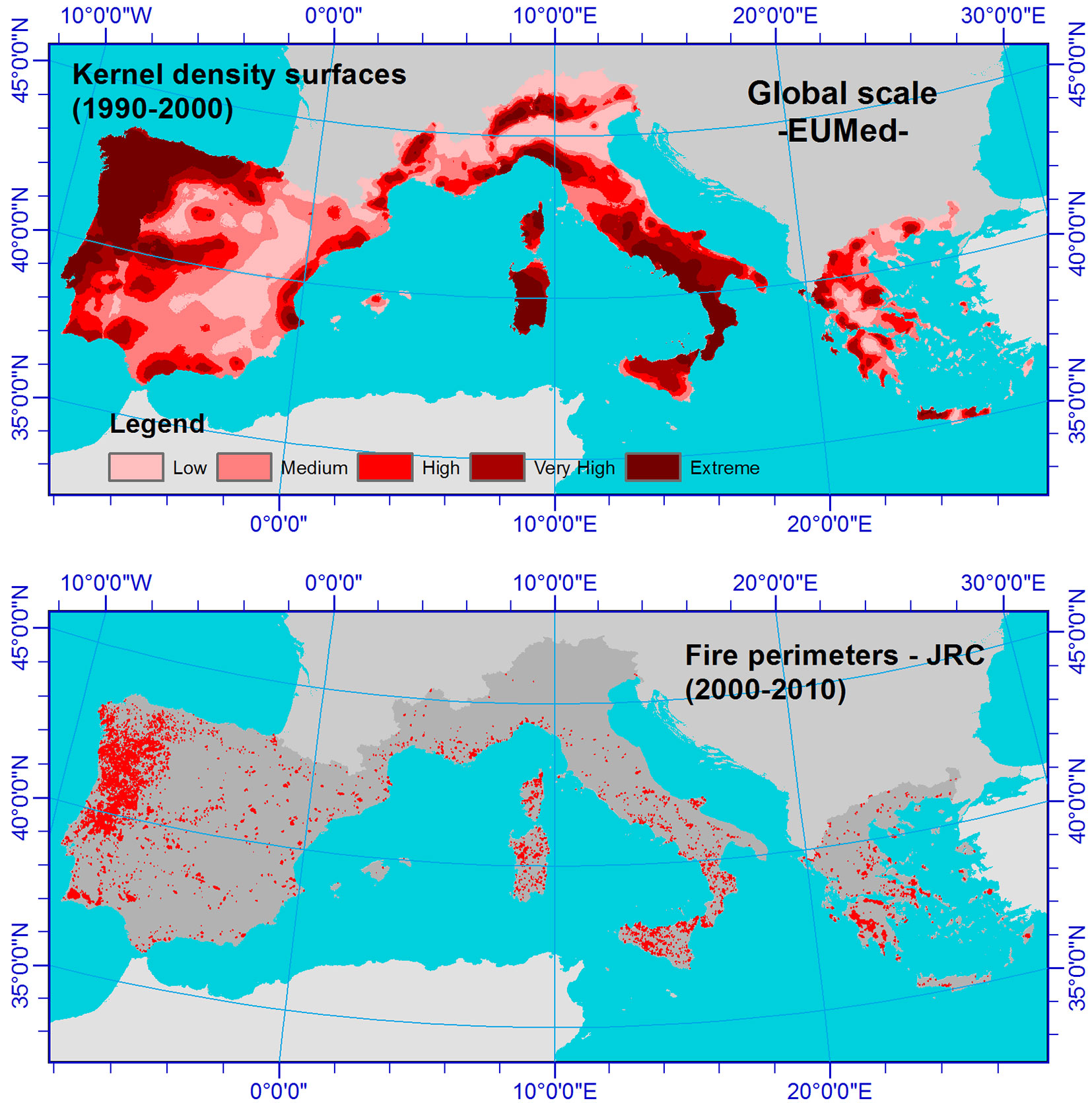
The fire occurrence zones at EUMed scale (Fig. 5), based on the kernel density interpolation, result from the EU research project SPREAD ([1]). The aim of this study was to define large-scale wildland fire occurrence patterns and to identify “fire hot-spot areas” in southern Europe by using fire ignition observations aggregated at community level. An adaptive kernel density interpolation approach was followed, in which the (geographically defined) community centroids represent the “spatial anchor points”, and where the number of fires per community was used as the intensity variable for the kernel density estimation calculations. After several experiments, locally varying bandwidth sizes proved to perform best, and the interpolation of 10 community centroids under the same kernel showed a reasonable variability in the resulting density surfaces.
Fig. 5 - Fire occurrence zones based on kernel density surfaces at European/global scale in the European Mediterranean Basin.
Evaluation of fire occurrence zones
The Peloponnese regional scale
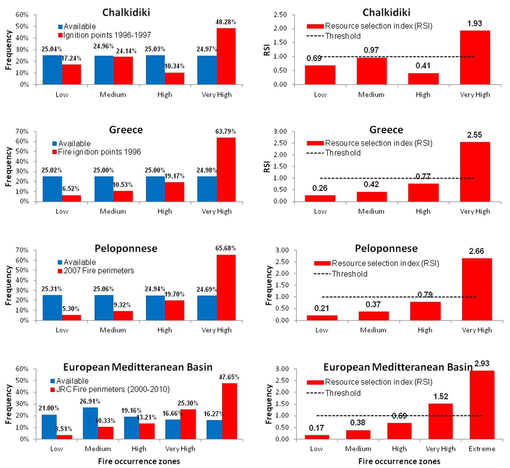
The fire scars of 2007, the year with the highest total of burned areas ever recorded in Greece ([32]), were overlaid onto the fire occurrence zones (Fig. 3), and the distribution observed was estimated and compared with its random expectation (Fig. 6). The observed distribution of fire occurrence zone values was statistically significantly different to the expected distribution under a complete spatially random process. For the occurrence zone value of 4 (very high) the percentage was 65.68% (Fig. 3), much higher than and statistically significantly different to the expected one of 24.69%. The resource selection index is higher than the threshold value of 1 only in the case of the highest risk zone (2.66), denoting positive selectivity (preference) of the fires, while all the others have values below 1, denoting negative selectivity (avoidance) of the fires.
Fig. 6 - (left panel) The observed distribution of fire parameters (ignition points, fire perimeters) was compared to the expected one at the different scales of analysis using a Monte Carlo randomization test. (right panel) A resource selection index, defined as the ratio of the observed over available to burn ratio, was estimated and used to show the fire selectivity in the different fire occurrence zones. For more details, see the text.
Greece national scale
The wildfire ignition points of 1996, one year after the period 1985-1995 used to run the kernel density interpolation, were overlaid onto the fire occurrence zones (Fig. 4) and the distribution observed was estimated and compared to the expected one (Fig. 6). The observed distribution of fire occurrence zone values was statistically significantly different to the expected one under a complete spatially random process. Again, for occurrence zone 4 (very high) the percentage was 63.79% (Fig. 4), much higher than and statistically significantly different to the expected one of 24.98%. The resource selection index was higher than the threshold value of 1 only in the case of the highest risk zone (2.55), denoting positive selectivity (preference) of the fires, while all the others presented values below 1, denoting negative selectivity (avoidance) of the fires.
European Mediterranean Basin Global EUMed scale
The fire perimeters of 2000-2010, one decade after the period used to run the kernel density interpolation, were overlaid onto the fire occurrence zones (Fig. 5). The observed distribution was estimated and compared with the random expectation (Fig. 6). The observed distribution of fire occurrence zone values was statistically significantly different to the expected distribution under a complete spatially random process, since especially for occurrence zone 5 (extreme) the percentage was 47.65% (Fig. 5), much higher than and statistically significantly different to the expected one of 20% (actually 16.27%). The resource selection index was higher than the threshold value of 1 only for the extreme (2.93) and very high zones (1.52), thus denoting positive selectivity (preference) of the fires. The other zones presented values below 1, thus denoting negative selectivity (avoidance) of the fires.
Discussion
As the recent observed changes in wildland fire regimes are increasingly affecting human and ecological resources, a need has arisen to develop quantitative strategies and approaches for fire risk management, including methods for risk assessment (exposure and effects) and mitigation of fire effects ([42], [63], [76]). The effects of fire on landscape may vary from region to region because of differences in regeneration patterns among main land cover types, topographic constraints and local fire histories ([74], [9]). Despite the fact that the majority of fires have human causes, fire ecology models often fail to integrate human land and fire use patterns as, for example, most savanna ecology models ([35]). Additionally, fire incidence depends not only on structural factors such as the type of vegetation or climate conditions, but also on spatial factors ([73]). In general, variables defining landscape composition or proximity to human influence ([48]), along with landscape structure ([75]) and human activities such as agriculture and construction related to development projects, are also important underlying factors of fire risk in the Mediterranean ([39]), while their spatial relationships may vary ([31]). Under this perspective fire-fighting organizations design and implement operational projects to successfully prevent, forecast and suppress forest fires. Many factors such as specialized requirements and personnel, labor, availability of necessary means and usually limited economic resources compete to optimize such efforts and actions. Wildland fire occurrence zoning helps to orient the managers a priori towards the proper civil protection actions, while it might be a strategic operational advantage for the proper development of a Decision Support System (DSS).
At the local/regional scale, the proposed method could be used to design prevention planning programs to reduce the risk of fire ignition. Fire occurrence zones could be used to guide and prioritize fuel treatments across fire-prone landscapes and resources. Fuel treatments such as prescribed burning and thinning may reduce the quantity, depth and vertical or horizontal continuity of fuels, changing surface fire spread rates and reducing the likelihood of crowning fire behavior ([16]). However, as stated by Fernandes et al. ([20]), the adoption of prescribed burning in the Mediterranean Basin has been slow, uneven and inconsistent. Its development is constrained by cultural and socioeconomic factors as well as by specific factors related to demography, land use, and landscape structure. Additionally, fire occurrence zones could be used to identify areas where fine-scale modeling of fire spread dynamics should be considered, and identify areas where mitigation strategies limit fire intensity and spread ([62]). Furthermore, fire occurrence zones could be efficiently used to simulate the effectiveness of the initial attack, to allocate available fire fighting resources and to coordinate fire dispatching levels, staff schedules and deployment, and line-building tactics ([21]). Kernel-based occurrence zones could be adopted in different landscapes to allocate fuel breaks, reduce resource costs and maximize their efficiency in controlling wildfire spread ([68]). Additionally, fire occurrence zones could be used to highlight areas where the development of ground fire surveillance and early-detection systems is crucial for forest protection and instant forest fire suppression ([70]).
Finally, at regional scale, fire occurrence zones may prove very helpful when approaching the wildland-urban interface problem which is very common in Mediterranean countries. Fire occurrence zones can be overlaid over urban and rural designated areas, thereby defining critical regions where the wildland-urban as well as the wildland-rural interface become a potential problem for society as far as forest fires are concerned ([61]). As stated by Koutsias et al. ([32]), forest fires in the wildland-urban interface have become very common in Europe as population and human infrastructure facilities are disseminated throughout forested zones, especially in the vicinity of large cities and tourist resorts ([78]), and also due to afforestation of abandoned agricultural lands located close to settlements ([22]). Major social and economic changes in land use have affected both the wildland-rural interface and the wildland-urban interface resulting in increased quantities of biomass (fuel), higher exposure to human-induced fire, and conflicts ([54], [40], [22], [45], [19]). At the national scale, kernel density surfaces could be used as a standard procedure for more reliable and site-specific early warning systems of fire danger estimation in countries that differ in physical and socioeconomic conditions ([77], [69]). In addition, fire occurrence zoning may offer a strategic operational advantage for the proper development of a DSS ([26]), since such efforts can be applied with spatial and temporal priorities within fire-prone regions. Thus, reduction of the necessary costs and maximization of the benefits and outcomes ([59]) can be addressed more adequately (cost/benefit analysis). Another asset of kernel-based occurrence zoning is that the distribution and mapping of fire risk and behavior ([52]) could be used for spatial allocation of human and economic resources throughout the year for fire program planning and regional development, as well as for implementing environmental policies, law enforcement, educational activities and advanced engineering of fire prevention at national levels ([58]). Based on fire occurrence zoning, hazard mitigation and monitoring programs may also be revised using alternative scenarios and focus on identified and educated objectives and impacts. Overall, wildland fire occurrence zoning has the potential to orient a priori national land-management authorities towards optimal actions for emergency risk management and civil protection.
European scale policies on forest fires require comprehension of the underlying mechanisms and relationships between biophysical factors, landscape characteristics, people, and wildland fires within and among the different countries. A pan-European approach also requires methods that ignore national boundaries to more clearly identify European patterns of similarities and differences. Lack of complete and comparable data, along with the complexity of factors influencing fire occurrence and risk, impose limitations to the systematic investigation of long-term fire occurrence and risk when using modeling approaches based on physical, socioeconomic and demographic explanatory variables ([49]). The kernel zoning approach can be used to create fire occurrence zones on a European level and used to help design prevention policies adapted to the socioeconomic, cultural and environmental conditions of each region and nation ([23]).
Establishment of robust fire occurrence and fire risk zones is a necessary basic step to develop and coordinate effective European response mechanisms. A transboundary spatially explicit risk estimate may enhance cooperation between the European member states and the implementation of best practices in forest fire prevention and fire fighting. Nowadays, there is a need for information on fire risk that could support integrated and long-term approaches for wildland fire management in Europe. Development of common European approaches and policies on fire management is required due to the transboundary effects of wildland fires, the existence of many diverse environmental causes and consequences related to this risk which require coordination at European Union scale ([43]). Currently, the European Forest Fire Information System (EFFIS) which is a modular DSS that monitors forest fires at a continental scale and delivers real-time, multi-dimensional data ([41]), justifies the need for coordinated common approaches to fire management in Europe. Since its establishment, EFFIS, whose objective is to provide accurate data to assess and mitigate the impacts of wildfire events on society and the environment ([41]), has influenced the further development of EU environmental policies on forest protection ([64]).
In summary, alternative and/or complementary to some of the classical fire occurrence and fire risk assessment methods, we propose a fire occurrence zoning approach at multiple spatio-temporal scales and extents in order to identify homogeneous areas of similar fire occurrence, based solely on documented historical fire observations. At national or global scales the proposed methodology could allow rapid identification and targeting of high-risk areas to develop and implement detailed fire risk models. Furthermore, these fire occurrence zones could be one of the basic inputs for generating mechanistic hypotheses and constructing large-scale fire risk maps aimed at more reliable spatial and temporal prediction of wildland fire occurrence. Fire occurrence zoning based solely on documented historical fire occurrence records is more straightforward and less demanding on statistical assumptions compared to model building approaches.
Finally, two important issues of kernel density are worth to be discussed: (i) the mode of the kernel, i.e., fixed versus adaptive mode; and (ii) the size of the smoothing parameter of the kernel.
To implement kernel density estimation in wildland fire occurrence, the fixed mode approach can be adopted to keep the smoothing parameter of the kernel constant over the entire study area for avoiding different treatments of the point observations over areas with different point density. On the other side, when fire data are aggregated to community centroids the adaptive kernel density interpolation approach may be more useful, as this allows variation of the kernel size according to the density of the interpolated points. This enables the different treatment of the point observations over areas with different point density according to the spatial arrangement of community centroids that is not constant throughout the whole study area. Indeed, in some areas the community density is high because the geographic extent of the communities is small, while in others the opposite holds. Therefore, over- or under-estimation of fire occurrence is likely.
In addition to the choice of the kernel type, the choice of the smoothing parameter is crucial, since it controls the amount of variation of estimates ([80]). To define the size of the bandwidth, the mean nearest distance of fire ignition points may be considered. The association of the size of the smoothing parameter of the kernel to the mean nearest distance is reasonable, since the amount of point observations that has to be interpolated is related to the information content. If the sample size is large, which corresponds to more informative datasets, then a finer interval resolution would be more suitable to avoid over-smoothing and loss of the variability in the estimates. For small size samples, which correspond to less informative datasets, a large bandwidth would be more appropriate, since a fine interval would lead to density estimations that may be perceived as nothing more than a random variation. The size of the smoothing parameter also defines the level of scale of the estimates; large intervals diminish local variability and their estimates are associated with global patterns, while narrow intervals preserve data variability and are associated to local patterns ([29]).
Conclusions and future prospects
This study proposes and evaluates a relatively new concept for creating forest fire occurrence zones at multiple scales based on documented historical fire records. An attractive feature of the proposed concept is the consistency it provides among different scales in terms of both methods and data ([10]). The present study demonstrates that application of the kernel density technique may improve the simple visualization-oriented use ([18], [29], [2]), thus becoming a useful analytical tool for fire risk management. One drawback of our approach, however, is that it considers only documented fire history data to create fire occurrence zones, and therefore does not capture any changes that might occur in fire drivers and underlying causal factors, such as those that might be induced either by future climate change or other land cover changes due to human activity, which is very common in the Euro-Mediterranean region ([65]).
Future work should explore the assessment of fire occurrence zones considering alternative scenarios such as fire size (e.g., only large recorded wildfires), fire causal factors (e.g., lightning), and other parameters of the fire event (e.g., time of ignition). This information could help fire-managers to identify areas where ad hoc, effective fire prevention measures should be introduced or, alternatively, more detailed, large-scale fire risk analysis and modeling should be applied.
Acknowledgements
The kernel density zones of the European Mediterranean Basin were created within the EC project “Forest Fire Spread and Mitigation (SPREAD)”, EC-Contract Nr. EVG1-CT-2001-00027, and the Federal Office for Education and Science of Switzerland (BBW), BBW-Contract Nr. 01.0138. We acknowledge the European Forest Fire Information System (EFFIS) of the European Commission Joint Research Centre, the Hellenic Fire Brigade and the Hellenic Forest Service for providing wildland fire data used in our study.
References
Gscholar
Gscholar
CrossRef | Gscholar
Gscholar
Gscholar
CrossRef | Gscholar
CrossRef | Gscholar
Online | Gscholar
Gscholar
Gscholar
Online | Gscholar
Authors’ Info
Authors’ Affiliation
Department of Environmental and Natural Resources Management, University of Patras, G. Seferi 2, GR-30100 Agrinio (Greece)
Museum of Natural History, Canton of Lucerne, Kasernenplatz 6, CH-6003 Lucerne (Switzerland)
Department of Geography, University of the Aegean, University Hill, GR-81100 Mytilene (Greece)
Department of Forestry & Management of the Environment and Natural Resources, Democritus University of Thrace, Pantazidou 193, GR-68200 Orestiada (Greece)
Ministry of Environment, Energy, and Climatic Change, Directorate General for Development and Protection of Forests and Natural Environment, Halkokondili 31, GR-10164, Athens (Greece)
Global Fire Monitoring Center (GFMC), Max Planck Institute for Chemistry, c/o Freiburg University/ United Nations University, Georges-Koehler-Allee 75, D-79110 Freiburg (Germany)
Corresponding author
Paper Info
Citation
Koutsias N, Allgöwer B, Kalabokidis K, Mallinis G, Balatsos P, Goldammer JG (2015). Fire occurrence zoning from local to global scale in the European Mediterranean basin: implications for multi-scale fire management and policy. iForest 9: 195-204. - doi: 10.3832/ifor1513-008
Academic Editor
Davide Ascoli
Paper history
Received: Nov 24, 2014
Accepted: Sep 11, 2015
First online: Nov 12, 2015
Publication Date: Apr 26, 2016
Publication Time: 2.07 months
Copyright Information
© SISEF - The Italian Society of Silviculture and Forest Ecology 2015
Open Access
This article is distributed under the terms of the Creative Commons Attribution-Non Commercial 4.0 International (https://creativecommons.org/licenses/by-nc/4.0/), which permits unrestricted use, distribution, and reproduction in any medium, provided you give appropriate credit to the original author(s) and the source, provide a link to the Creative Commons license, and indicate if changes were made.

Web Metrics
Breakdown by View Type
Article Usage
Total Article Views: 58156
(from publication date up to now)
Breakdown by View Type
HTML Page Views: 46970
Abstract Page Views: 4715
PDF Downloads: 4993
Citation/Reference Downloads: 44
XML Downloads: 1434
Web Metrics
Days since publication: 3877
Overall contacts: 58156
Avg. contacts per week: 105.00
Article Citations
Article citations are based on data periodically collected from the Clarivate Web of Science web site
(last update: Mar 2025)
Total number of cites (since 2016): 26
Average cites per year: 2.60
Publication Metrics
by Dimensions ©
Articles citing this article
List of the papers citing this article based on CrossRef Cited-by.
Related Contents
iForest Similar Articles
Research Articles
Distribution factors of the epiphytic lichen Lobaria pulmonaria (L.) Hoffm. at local and regional spatial scales in the Caucasus: combining species distribution modelling and ecological niche theory
vol. 17, pp. 120-131 (online: 30 April 2024)
Research Articles
Scale dependency of the effects of landscape structure and stand age on species richness and aboveground biomass of tropical dry forests
vol. 16, pp. 234-242 (online: 23 August 2023)
Research Articles
Predicting the effect of climate change on tree species abundance and distribution at a regional scale
vol. 1, pp. 132-139 (online: 27 August 2008)
Research Articles
Probabilistic prediction of daily fire occurrence in the Mediterranean with readily available spatio-temporal data
vol. 10, pp. 32-40 (online: 06 October 2016)
Research Articles
Forest fire occurrence modeling in Southwest Turkey using MaxEnt machine learning technique
vol. 17, pp. 10-18 (online: 02 February 2024)
Research Articles
Evaluation of hydrological and erosive effects at the basin scale in relation to the severity of forest fires
vol. 12, pp. 427-434 (online: 01 September 2019)
Research Articles
Differences of fire activity and their underlying factors among vegetation formations in Greece
vol. 6, pp. 132-140 (online: 08 April 2013)
Research Articles
Post-fire recovery of Abies cephalonica forest communities: the case of Mt Parnitha National Park, Attica, Greece
vol. 11, pp. 757-764 (online: 15 November 2018)
Research Articles
Assessment of sanitary conditions in stands of Norway spruce (Picea abies Karst.) damaged by spruce bud scale (Physokermes piceae Schrnk.)
vol. 6, pp. 73-78 (online: 07 February 2013)
Short Communications
Upscaling the estimation of surface-fire rate of spread in maritime pine (Pinus pinaster Ait.) forest
vol. 7, pp. 123-125 (online: 13 January 2014)
iForest Database Search
Search By Author
Search By Keyword
Google Scholar Search
Citing Articles
Search By Author
Search By Keywords
PubMed Search
Search By Author
Search By Keyword


