Calibration assessment of forest flammability potential in Italy
iForest - Biogeosciences and Forestry, Volume 7, Issue 5, Pages 300-305 (2014)
doi: https://doi.org/10.3832/ifor1123-007
Published: May 07, 2014 - Copyright © 2014 SISEF
Research Articles
Abstract
Fuel flammability is defined as the relative ease with which a fuel will ignite and burn with a flame; different forest types have different intrinsic “baseline” flammabilities, depending on the susceptibility to burn of the main tree species that build up the forest cover. In this perspective, we apply a forest-type based approach to classify and map the flammability level of the forests in Italy. Baseline forest type-based flammability values provided at European level have been assigned to a national forest types map, derived from Corine Land Cover 2006; flammability values have been then further calibrated against the Burned Area Selection Ratio, a measure of the actual incidence of wildfires among different forest types. Accordingly, a calibrated flammability index was derived by simple linear regression, so that predicted flammability more accurately reflects observed fire incidence among different forest types in Italy. Findings show that the flammability of forest types ranges from low to high: on average, the 17% of the forest cover has medium to high flammability, with wide regional variability; notably, in four Regions (Sardegna, Sicilia, Puglia, Calabria) over one third of total forest area has medium to high flammability. Large scale mapping of forest flammability is crucial to define long-term priorities among forest areas as to how to distribute fire management effort: areas falling into medium to high flammability classes should be given priority for implementing fuel management treatments in order to mitigate fire hazard from the stand to the landscape scale.
Keywords
Fuel Flammability, Fire Hazard, European Forest Types, Burned Area Selection Ratio, Fire Management
Introduction
Fuel flammability is defined as the relative ease with which a fuel will ignite and burn with a flame ([30]). It plays a paramount role in the reaction of wildland fuels to heat exposure, thus influencing the spatial pattern of fire ignition risk. Accordingly, flammability is a key determinant of fire hazard, i.e., the degree of both ease of ignition and fire suppression difficulty of the fuels ([15]).
According to Anderson ([2]) and Trabaud ([31]), flammability can be defined through three variables that describe how well the fuel ignites (ignitibility), how well it burns (combustibility) and how long it burns (sustainability). Notably, in Mediterranean trees (e.g., Pinaceae and Cupressaceae) the abundance of organic oils and organic volatile compounds and terpenes, whose flash points are low, largely contributes to the ignition and spread of fire ([1]); at the same time, the susceptibility to burn of any given fuel is manifested only under particular weather conditions, as it is largely dependent on fuel moisture content.
The general sense of the flammability concept can be easily grasped, but it is harder to define it more closely for scientific purposes ([20]). Although flammability components can be measured by laboratory and field experiments (e.g., [27]), translation of laboratory results to field conditions is highly problematic ([17]). Moreover, field experiments are usually expensive ([32]).
As a matter of fact, many variables do affect fuel flammability at leaf, plant and forest stand level, including structural characteristics of the fuels, moisture content, chemical composition and fuel spatial arrangement ([33]). The interplay of forest composition and stand structure is crucial to influence forest fuel flammability at stand scale. On one hand, the “baseline” flammability level of a forest type is primarily driven by the fuels produced by the main tree species that build up the forest cover. On the other hand, fire hazard might be widely variable even in stands composed of flammable forest species, depending on forest stand structure and fuel accumulation ([16]).
Considering that fire management resources are limited, it is crucial to provide fire managers with operational methodologies to assess fire hazard over large forest areas (a country or a region). A landmark approach to fire hazard mapping is fire behavior modeling. Fuel models are mathematical representations of fuel properties within a specified location ([30]), used to predict and plot likely fire spread and intensity by means of fire behavior models, packaged into decision support systems (e.g., FARSITE - [18], BehavePlus - [21]). However, the implementation of fire modeling on a large scale is inherently limited by the difficulty and high cost of yielding accurate geospatial data on fuels ([25]). In this perspective, a large scale map of forest flammability potential can be a valuable decision support tool to assess need and priorities in fire management, e.g., to support the effectiveness of fire prevention, detection and allocation of fire fighting resources ([7]). Following this line, the paper presents a methodological framework to classify and map the flammability level of main Italian forest types by processing spatial data on forest cover composition and recent fire history. Baseline forest type-based flammability values provided at European level by Xanthopoulos et al. ([33]) have been calibrated against the Burned Area Selection Ratio (BASR), a measure of the actual incidence of wildfires among different forest types ([8]).
Study area
Land covered by forests in Italy (sensu [14]) amounts to 8.8 millions of hectares, nearly 30% of the country’s territory ([22]). The most widespread forest types are dominated by oaks, beech and chestnut, each exceeding one million hectares; spruce-dominated woodlands are the most extensive coniferous forests (0.6 millions of hectares).
The total amount of aboveground biomass and deadwood shows significant differences between broadleaved and coniferous dominated forest types ([23]): on average, it is lower (60-130 Mg ha-1) in oak forests, chestnut and Turkey oak forests, due to coppice forest management, than in forest formations dominated by coniferous species (80-240 Mg ha-1). Deadwood accumulation mainly depends on the level of silvicultural abandonment and/or on the age of forest stands, ranging from 3% (beech forest, alti-mediterranean pine forest, Turkey oak forest, Italian oak forest, Macedonian and Valonian oak forest, cork oak forest) to 12% (chestnut and Turkey oak forests) of the total aboveground biomass and deadwood amount.
The combination of such a great diversity of forest physiognomies and stand structures makes Italian forests an interesting case study to test methods in large scale mapping of forest flammability.
Materials and methods
Geospatial datasets
The most updated geospatial dataset to map forest cover types is the Corine Land Cover 2006 ([12], [13]). Corine Land Cover is a European-wide land cover database in vector format available for the reference years 1990, 2000 and 2006; main CLC technical features are: (i) a standard nomenclature including 44 land cover classes, grouped in a three-level hierarchy; (ii) scale (1:100 000) and the minimum mapping unit (25 ha) optimized for nation-wide applications; (iii) mapping methodology based on computer assisted visual interpretation of satellite images (Landsat series). CLC standard nomenclature maps forest cover in three classes (broadleaves, coniferous and mixed forest). However, as part of the national implementation activities of the CLC project, a fourth hierarchical level has been introduced in Italy since CLC 2000 to map forest and semi-natural areas with a higher thematic detail ([24]). Accordingly, the three third-level forest classes can be further classified into nine main forest types based on the dominant forest species (see Tab. 1).
Tab. 1 - Baseline flammability of main forest types in Italy according to the assessment scheme by Xanthopoulos et al. ([33]).
| Corine Land Cover (2006) forest types | European Forest Type Classification | Flammability index |
|---|---|---|
| Broad-leaved evergreen forest |
9.1 Mediterranean evergreen oak forest | 3.4 |
| Deciduous oak forest |
8.1 Downy oak forest | 2.05 |
| 8.2 Turkey oak forest | ||
| Other broad-leaved forest | 8.8 Other thermophilous deciduous forests | 2.5 |
| Chestnut forest | 8.7 Chestnut forest | 2.7 |
| Beech forest | 7.3 Apennine-Corsican mountainous beech forest | 2 |
| Mediterranean pine forest | 10.1 Mediterranean pine forest | 4.1 |
| High oro-Mediterranean pine forest | 10.2 Mediterranean and Anatolian black pine forest | 2.95 |
| 10.4 Mediterranean and Anatolian black pine forest | ||
| 10.5 Alti-Mediterranean Pine forest | ||
| Spruce/fir forest | 10.6 Mediterranean and Anatolian fir forest | 2 |
| Larch and arolla pine forest |
3.1 Subalpine larch-arolla pine and dwarf pine forest | 1.5 |
In order to quantify the actual incidence of wildfires amongst forest types (see BASR index below) we used the vector geodataset of areas affected by wildfires (forest and rural areas) recorded through GPS survey by the Italian National Forest Service (Corpo Forestale dello Stato, CFS). A full time series is currently available for the years 2006-2011 for 15 out of 20 NUTS2 level administrative units of Italy (the geodataset does not cover the five autonomous regions with special statute). The minimum mapping unit of burned areas is 2000 m2, with a number of fire events per year ranging from 1370 (year 2010) to nearly 5000 (year 2007).
Methodology
The assessment framework proposed by Xanthopoulos et al. ([33]) allows to assign a baseline flammability index (FI), reflecting typical fire hazard for 60 vegetation types of Europe and north Africa and their corresponding classes in the European Forest Types (EFTs) classification ([6]). The whole range of variation of the FI is ranked into five classes ([33]):
- very low (1<
FI<1.8) - low flammability even under extreme conditions (e.g., temperature > 38 °C, relative humidity < 15%, windspeed > 30 km h-1); - low (1.8<
FI<2.6) - flammable under extreme conditions when the number of fire starts can be considerable and the fires quite active; - medium (2.6<
FI<3.4) - fires can be numerous under hot summer conditions and they are likely to present significant control problems requiring efforts and resources; - high (3.4<
FI<4.2) - fires are very likely under hot summer conditions; they can escape initial attack if not attacked effectively and then will defy direct frontal attack; - very high (4.2<
FI<5.0) - fires can be plentiful even under relatively mild fire season conditions; they are likely to escape all but the best initial attack efforts under high fire danger conditions, in which case they will defy direct control efforts at their front until conditions change; under extreme fire weather conditions they can result in mega-fires.
In order to assign the FI to main Italian forest types, a correspondence between the national forest types map derived from the [12] and the European Forest Types classification has been established (Tab. 1).
EU level flammability values have been further calibrated against the Burned Area Selection Ratio (BASR). BASR is a measure of actual fire incidence by forest type classes, defined as the ratio between percentage of burned area of a given forest type compared to the total burned forest area and the percentage of the area of the forest type compared to the total forest area ([8] - eqn. 1):
where AB is the burned area of the considered forest type, TB is the total burned forest area, Ar is the area of the considered forest type, and Tr is the total forest area.
A BASR value higher than 1 indicates that the considered forest type burns more often than would be the case if fires occur randomly. Therefore, the BASR index can be regarded as a robust measure to validate and calibrate baseline flammability values at national scale.
The BASR was calculated by a GIS operation of geometric intersection of the inputs geodatasets [12] and 2006-2011 fire perimeters. As repeated burning of forest types dominated by oaks, chestnut or Mediterranean pines has been occurring in Italy in the period 2006-2011 ([5]), the AB term was calculated as the sum of the areas of single fire events, occurred in the period 2006-2011, within Ar as mapped by [12] in the 15 NUTS2 level administrative units.
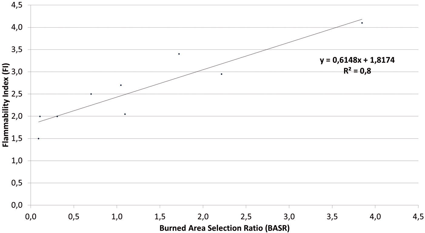
Regression analysis was then performed to quantify the relationship between FI and BASR values for the nine forest types classes of the [12] dataset (Fig. 1). The high value of the coefficient of determination (R2=0.80) indicates a good fitting of baseline flammability values (FI) to the observed fire incidence (BASR). Moreover, the regression line values fall within the range of variability of the flammability index (1-5). Accordingly, a calibrated flammability index (Tab. 2) was derived as a linear function of BASR (see Fig. 1 equation).
Fig. 1 - Correlation between the flammability index (FI) and the burned area selection ratio (BASR) for the forest types reported in Tab. 1.
Tab. 2 - Calibrated flammability index for the forest types reported in Tab. 1.
| Corine Land Cover (2006) forest types | Calibrated flammability index |
|---|---|
| Larch and arolla pine forest | 1.87 |
| Spruce/fir forest | 1.88 |
| Beech forest | 2.01 |
| Other broad-leaved forest | 2.25 |
| Chestnut forest | 2.46 |
| Deciduous oak forest | 2.49 |
| Broad-leaved evergreen forest | 2.88 |
| High oro-Mediterranean pine forest | 3.18 |
| Mediterranean pine forest | 4.18 |
Results and discussion
All the nine forest types considered in this study were affected by forest fires in the 2006-2011 period, but the total size of area affected by fire and BASR varies considerably between forest types (Fig. 2). In absolute terms, deciduous oaks and chestnut forests have the highest values of total burned area (over 30 000 and 10 000 hectares, respectively, in the considered time period). However, the rate of incidence of fire in these forest types is in balance with their relative coverage, with a BASR value close to 1 (see Fig. 2).
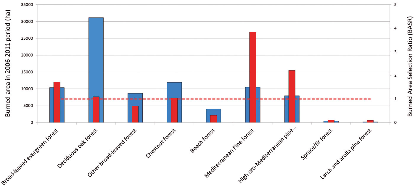
On the whole, BASR ranges from 0.09 to 3.85. Mediterranean Pine forests have a disproportionately high fire occurrence (BASR = 3.85), followed by High oro-Mediterranean pine forests (BASR = 2.21) and broad-leaved evergreen forests (BASR = 1.72). Although BASR values of forest types show regional variations, the absolute difference of BASR national value and average of BASR regional values is small relative to the range of the index: it ranges from 0.1 (beech forest) to 0.9 (broadleaved evergreen forest). Therefore, BASR national values can be regarded as good predictors of wildfire susceptibility even at regional level.
Tab. 2 reports the calibrated values of the flammability index for each forest type. The calibrated flammability index, building on information on observed fire incidence, represents a more reliable forest type-based rating of forest flammability potential in Italy. The calibration approach adopted here is founded on the principle of resource selection function (sensu [28] - for relevant applications to forest fires, see [4] and [29]), thus providing the baseline flammability values with a likelihood based on recent fire history. This puts forward a significant improvement in the quantification of flammability proposed by Xanthopoulos et al. ([33]), which is based on expert assessment and consequently has a component of subjectivity. On the other hand, it is worth noting that the absolute value of the differences between the calibrated values and the baseline proposed by Xanthopoulos et al. ([33]) are not higher than 0.5, and that such small a deviation does not change the ranking of forest types flammability values into the five classes, except for chestnut forest (baseline: medium; calibrated: low flammability).
The approach proposed here has not been conceived to replace fire behavior modeling, which objectively quantify the potential for burning, but it is not still operational for fire hazard mapping over large forest areas, although the cost of mapping fuel models could be considerably reduced in the future by more widespread availability of Airborne Laser Scanning data (e.g., [19], [11]).
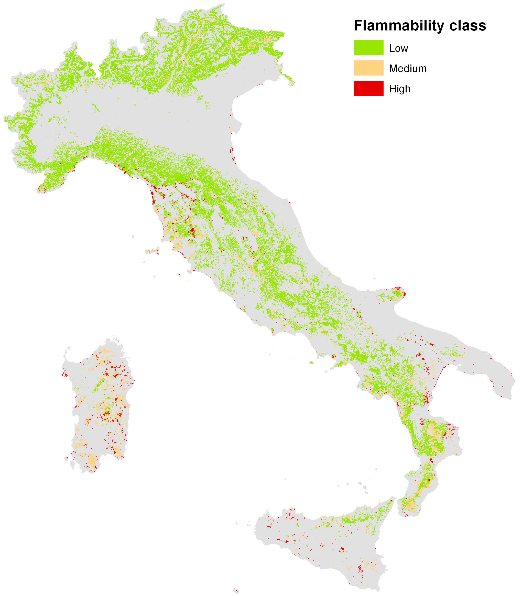
The operational outcome of the proposed methodology is rather the stratification of fire hazard in terms of forest flammability potential assessed from forest type maps, which are usually available over large areas, as shown in Fig. 3. Based on this approach, fire hazard can be quantified for any given territorial units, e.g., NUTS2 administrative Regions (Tab. 3). The flammability of the forests proves to be extremely variable across the country: on average, 17% of the forest cover has medium to high flammability, with wide regional variability. Notably, in four regions (Sardegna, Sicilia, Puglia, Calabria) over one third of total forest area has medium to high flammability.
Fig. 3 - Map of the forest flammability potential in Italy.
Tab. 3 - Relative share of forest area by flammability levels and administrative Regions in Italy.
| Administrative Region |
Share of forest area by flammability level (%) | |||
|---|---|---|---|---|
| low | medium | high | medium to high |
|
| Sardegna | 7 | 75 | 18 | 93 |
| Sicilia | 51 | 30 | 19 | 49 |
| Puglia | 57 | 20 | 24 | 43 |
| Calabria | 63 | 33 | 4 | 37 |
| Valle d’Aosta | 75 | 25 | 0 | 25 |
| Toscana | 81 | 16 | 3 | 19 |
| Campania | 83 | 16 | 1 | 17 |
| Basilicata | 85 | 12 | 3 | 15 |
| Umbria | 86 | 12 | 2 | 14 |
| Lazio | 87 | 12 | 1 | 13 |
| Liguria | 91 | 6 | 4 | 9 |
| Trentino Alto Adige | 91 | 8 | 0 | 9 |
| Abruzzo | 94 | 6 | 0 | 6 |
| Friuli Venezia Giulia | 95 | 5 | 0 | 5 |
| Marche | 95 | 4 | 1 | 5 |
| Molise | 97 | 2 | 1 | 3 |
| Veneto | 97 | 3 | 0 | 3 |
| Lombardia | 98 | 2 | 0 | 2 |
| Emilia Romagna | 98 | 2 | 0 | 2 |
| Piemonte | 99 | 1 | 0 | 1 |
| Italy | 83 | 14 | 3 | 17 |
Conclusions
Fire ignition risk and fire hazard over large forest areas are primarily determined by flammability of forest fuels. It is impossible to modify these characteristics at a reasonable cost, but it is possible to provide fire managers with information on priority areas, i.e., those with high fire hazard. In these areas, optimizing fuel treatment techniques, like prescribed burning, may be very effective to achieve fire hazard reduction goals ([3]). These practices are even more strategic in landscape settings and forest types affected by short-term fire wildfire recurrence ([5]).
In this perspective, the methodological approach proposed by this study offers a significant contribution. Calibration of forest type-based baseline values of forest flammability against the Burned Area Selection Ratio can be regarded a robust procedure to evaluate and compare the fire hazard potential between different forest types and to map their flammability levels over large forest areas accordingly. Furthermore, the proposed methodological approach can be easily applied also in other Mediterranean countries, like e.g., Spain, Portugal and Greece, where forest types maps and geospatial information on forest fire perimeters are available ([10]).
Large scale mapping of forest flammability can result in significant improvements in fire management: it provides information about the (static) spatial pattern of fire hazard over a country or a region. Such information is essential to define long-term priorities among forest areas as to fire management effort. For instance, areas falling into medium to high flammability classes at regional level should be given priority for fire prevention, i.e., for planning and implementing fuel management treatments to mitigate fire hazard from the stand to landscape scale ([26]). At the same time, knowledge of spatial pattern of fire hazard can be integrated with daily fire danger maps, based on meteorological conditions affecting fuel moisture content and related flammability. As an example, EFFIS (⇒ http://forest.jrc.ec.eu ropa.eu/effis/applications/current-situation/) daily maps of 1 to 6 days projected fire danger level, based on the Fire Weather Index can be used to further stratify forest type-based flammability maps, in order to improve the effectiveness of fire detection and allocation of fighting resources during critical days of the fire season.
Acknowledgments
The work was financed by the project PRIN 2009 “in_FLAMING: Developing innovative models and techniques for integrated fuel management for fire prevention in Mediterranean and temperate forests” (coordinator: P. Corona) funded by the Italian Ministry for Education, University and Research.
References
Gscholar
Gscholar
Gscholar
CrossRef | Gscholar
Online | Gscholar
Online | Gscholar
Gscholar
Gscholar
Gscholar
Gscholar
Authors’ Info
Authors’ Affiliation
Consiglio per la Ricerca e la sperimentazione in Agricoltura, Forestry Research Centre (CRA-SEL), v.le S. Margherita 80, Arezzo (Italy)
Rosaria Cartisano
Anna Barbati
Department for Innovation in Biological Agro-food and Forest systems (DIBAF), University of Tuscia, via San Camillo de Lellis snc, I-01100 Viterbo (Italy)
Corresponding author
Paper Info
Citation
Corona P, Ferrari B, Cartisano R, Barbati A (2014). Calibration assessment of forest flammability potential in Italy. iForest 7: 300-305. - doi: 10.3832/ifor1123-007
Academic Editor
Raffaele Lafortezza
Paper history
Received: Sep 10, 2013
Accepted: Mar 06, 2014
First online: May 07, 2014
Publication Date: Oct 01, 2014
Publication Time: 2.07 months
Copyright Information
© SISEF - The Italian Society of Silviculture and Forest Ecology 2014
Open Access
This article is distributed under the terms of the Creative Commons Attribution-Non Commercial 4.0 International (https://creativecommons.org/licenses/by-nc/4.0/), which permits unrestricted use, distribution, and reproduction in any medium, provided you give appropriate credit to the original author(s) and the source, provide a link to the Creative Commons license, and indicate if changes were made.

Web Metrics
Breakdown by View Type
Article Usage
Total Article Views: 57139
(from publication date up to now)
Breakdown by View Type
HTML Page Views: 47447
Abstract Page Views: 3365
PDF Downloads: 4792
Citation/Reference Downloads: 60
XML Downloads: 1475
Web Metrics
Days since publication: 4416
Overall contacts: 57139
Avg. contacts per week: 90.57
Article Citations
Article citations are based on data periodically collected from the Clarivate Web of Science web site
(last update: Mar 2025)
Total number of cites (since 2014): 18
Average cites per year: 1.50
Publication Metrics
by Dimensions ©
Articles citing this article
List of the papers citing this article based on CrossRef Cited-by.
Related Contents
iForest Similar Articles
Review Papers
Remote sensing support for post fire forest management
vol. 1, pp. 6-12 (online: 28 February 2008)
Research Articles
Assessing the performance of MODIS and VIIRS active fire products in the monitoring of wildfires: a case study in Turkey
vol. 15, pp. 85-94 (online: 19 March 2022)
Research Articles
Harmonized dataset of surface fuels under Alpine, temperate and Mediterranean conditions in Italy. A synthesis supporting fire management
vol. 13, pp. 513-522 (online: 13 November 2020)
Research Articles
Fuel type characterization based on coarse resolution MODIS satellite data
vol. 1, pp. 60-64 (online: 28 February 2008)
Research Articles
Evaluation of hydrological and erosive effects at the basin scale in relation to the severity of forest fires
vol. 12, pp. 427-434 (online: 01 September 2019)
Research Articles
Multiple ways for enhancing flammability in Mediterranean woody species: a trait-based approach
vol. 18, pp. 301-308 (online: 20 October 2025)
Research Articles
Differences of fire activity and their underlying factors among vegetation formations in Greece
vol. 6, pp. 132-140 (online: 08 April 2013)
Short Communications
Upscaling the estimation of surface-fire rate of spread in maritime pine (Pinus pinaster Ait.) forest
vol. 7, pp. 123-125 (online: 13 January 2014)
Research Articles
Modeling human-caused forest fire ignition for assessing forest fire danger in Austria
vol. 6, pp. 315-325 (online: 16 July 2013)
Review Papers
Remote sensing-supported vegetation parameters for regional climate models: a brief review
vol. 3, pp. 98-101 (online: 15 July 2010)
iForest Database Search
Search By Author
Search By Keyword
Google Scholar Search
Citing Articles
Search By Author
Search By Keywords
PubMed Search
Search By Author
Search By Keyword


