Distribution of the major forest tree species in Turkey within spatially interpolated plant heat and hardiness zone maps
iForest - Biogeosciences and Forestry, Volume 5, Issue 2, Pages 83-92 (2012)
doi: https://doi.org/10.3832/ifor0611-005
Published: Apr 30, 2012 - Copyright © 2012 SISEF
Research Articles
Abstract
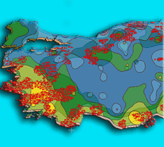
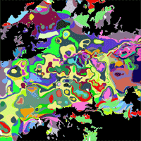
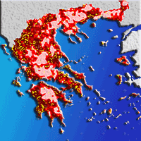
In disciplines such as agriculture, forestry and horticulture, it is customary to make use of various hardiness zone maps intended for the selection of the plant species to be cultivated within specific regions. The most widely used of these maps is the USDA Plant Hardiness Zone (PHZ) map. Recently, the American Horticultural Society also created the Plant Heat Zone (AHZ) Map. PHZ and AHZ maps have not yet been produced for Turkey. To overcome deficiencies of these maps and compare the distribution of major forest tree species over these zones, data from 260 meteorological stations recorded during the period from 1975-2008 and 458 144 forest stand-type polygon centroid data were used. PHZ and AHZ maps were created through the interpolation of meteorological data using the regularized spline with tension (RST) method. According to the interpolation results, there are 7 PHZs (4-10) and 8 AHZs (2-9) in Turkey. Finally, the distribution of 15 major forest tree species over these zones was investigated. The most commonly detected species were distributed among PHZs 5 and 10 coincided with Juniperus spp., Quercus spp. and Abies spp., and the species found between PHZs 5 and 10 were those exhibiting the most extensive distributions. Pinus brutia and Quercus spp. were found to be the most widely distributed species among the AHZs.
Keywords
Forest trees, Plant hardiness zones, Plant heat zones, Regularized spline with tension method, Turkey
Authors’ Info
Authors’ address
Corresponding author
Paper Info
Citation
Yilmaz OY, Tolunay D (2012). Distribution of the major forest tree species in Turkey within spatially interpolated plant heat and hardiness zone maps. iForest 5: 83-92. - doi: 10.3832/ifor0611-005
Academic Editor
Marco Borghetti
Paper history
Received: Nov 25, 2011
Accepted: Mar 27, 2012
First online: Apr 30, 2012
Publication Date: Apr 30, 2012
Publication Time: 1.13 months
Copyright Information
© SISEF - The Italian Society of Silviculture and Forest Ecology 2012
Open Access
This article is distributed under the terms of the Creative Commons Attribution-Non Commercial 4.0 International (https://creativecommons.org/licenses/by-nc/4.0/), which permits unrestricted use, distribution, and reproduction in any medium, provided you give appropriate credit to the original author(s) and the source, provide a link to the Creative Commons license, and indicate if changes were made.

Web Metrics
Breakdown by View Type
Article Usage
Total Article Views: 81012
(from publication date up to now)
Breakdown by View Type
HTML Page Views: 68277
Abstract Page Views: 5595
PDF Downloads: 5403
Citation/Reference Downloads: 42
XML Downloads: 1695
Web Metrics
Days since publication: 5174
Overall contacts: 81012
Avg. contacts per week: 109.60
Citation Metrics
Article Citations
Article citations are based on data periodically collected from the Clarivate Web of Science web site
(last update: Mar 2025)
Total number of cites (since 2012): 5
Average cites per year: 0.36
Publication Metrics
by Dimensions ©
Articles citing this article
List of the papers citing this article based on CrossRef Cited-by.
References
Turkiye’de Çam Turlerinde Tohum Transfer Rejyonlamasi. Orman Agaclari ve Tohumlari Islah Enstitusu Mudurlugu Yayinlari, Yayin No. 1, Ankara, Turkey.
Gscholar
Dogu Ladini (Picea orientalis L.) Tohum Transfer Rejiyonlamasi. Orman Agaclari ve Tohumlari Islah Arastirma Mudurlugu Yayinlari, Yayin No. 2, Ankara, Turkey.
Gscholar
Sedir (Cedrus libani A. Rich) Ormanlarinin Yayilis Gösterdigi Alanlar ve Yakin Cevresinin Genel Ekolojik Özellikleri ile Sedir Tohum Transfer Rejiyonlamasi. Orman Genel Mudurlugu Yayinlari, Yayin No. 663/61, Ankara, Turkey.
Gscholar
Kayin (Fagus orientalis Lipsky.) Ormanlarinin Ekolojisi ve Tohum Transferi Yonunden Bolgelere Ayrilmasi. Orman Agaclari ve Tohumlari Islah Arastirma Mudurlugu Yayinlari, Yayin No. 5, Ankara, Turkey.
Gscholar
Botanica: the illustrated A-Z of over 10.000 garden plants and how to cultivate them. Könemann, Hong Kong, pp. 1020.
Gscholar
Klimatoloji ve Metotlari. Istanbul Universitesi, Cografya Enstitusu Yayinlari, Istanbul, Turkey.
Gscholar
Alansal dagilim ozelligi gosteren iklim parametrelerinin cografi bilgi sistemleri ile belirlenmesi ve kullanim alanlari; genel bir bakis. Anadolu Journal of Agricultural Sciences 22: 322-328.
Gscholar
Eine neue Kartierung der Winterhärtezonen für Gehölze in Mitteleuropa. Mitteilungen der Deutschen Dendrologischen Gesellschaft 75: 11-56.
Gscholar
Provenance variation and provenance-site interaction in Pinus brutia Ten.: consequences of defining breeding zones. Silvae Genetica 49: 213-223.
Gscholar
Das geographische System der Klimate. In: “Handbuch der Klimatologie” (Koppen W, Geiger R eds). IC, Berlin, Germany.
Gscholar
Manual of cultivated broad-leaved trees and shrubs. Volume 1, Timber press, Beaverton, Oregon, USA.
Gscholar
Manual of cultivated broad-leaved trees and shrubs. Volume 2, B.T. Timber press, Portland, Oregon, USA.
Gscholar
Manual of cultivated broad-leaved trees and shrubs. Volume 3, B.T. Timber press, Portland, Oregon, USA.
Gscholar
Spatial interpolation. In: “GIS: principles, techniques, management and applications” (Longley P, Goodchild MF, Maguire, DJ Rhind DW eds). Wiley, USA, pp. 481-492.
Gscholar
Open Source GIS: a GRASS GIS approach (1st edn). Kluwer Academic Publishers, Boston, Dordrecht, London, pp. 464. [ISBN: 1-4020-7088-8]
Gscholar
Clasificacion bioclimatica de la tierra. Folia Botanica Matritensis 16: 1-32.
Gscholar
Southern pine seed sources. Gen. Tech. Rep. SRS-XX, Southern Research Station, USDA Forest Service, Asheville, NC, USA, pp. 25.
Gscholar
Ekoloji-Ekolojik Faktörler- Ekolojik Sorunlar. “Cevre Seminerleri 1998. CEKUL Cevre Dizisi 2” .Globus Dunya Basimevi, Istanbul, Turkey, pp. 77-90.
Gscholar
Related Content
Destan S, Yilmaz O, Sahin A
Vol. 6, pp. 268-277 (online: Oct 2013)
Hofmann M, Jager M, Bruelheide H
Vol. 7, pp. 282-288 (online: Oct 2014)
De Dato G, Teani A, Mattioni C, Marchi M, Monteverdi MC, Ducci F
Vol. 11, pp. 651-659 (online: Oct 2018)
Koutsias N, Allgöwer B, Kalabokidis K, Mallinis G, Balatsos P, Goldammer JG
Vol. 9, pp. 195-204 (online: Apr 2016)

Nunes A, Tápia S, Pinho P, Correia O, Branquinho C
Vol. 8, pp. 471-479 (online: Aug 2015)
Zhang R, Ma E
Vol. 14, pp. 313-319 (online: Aug 2021)
Nadezhdina N
Vol. 11, pp. 118-130 (online: Feb 2018)
Marcon B, Viguier J, Candelier K, Thevenon MF, Butaud JC, Pignolet L, Gartili A, Denaud L, Collet R
Vol. 16, pp. 1-9 (online: Feb 2023)

Goli G, Cremonini C, Negro F, Zanuttini R, Fioravanti M
Vol. 8, pp. 687-692 (online: Oct 2015)
Turfan N, Alay M, Sariyildiz T
Vol. 11, pp. 406-410 (online: Jun 2018)


