Hearing nature’s heartbeat: towards large-scale real-time forest monitoring network in Italy
iForest - Biogeosciences and Forestry, Volume 18, Issue 4, Pages 202-211 (2025)
doi: https://doi.org/10.3832/ifor4830-018
Published: Aug 09, 2025 - Copyright © 2025 SISEF
Research Articles
Abstract
Climate change undermines forests’ health, vitality, and, as a consequence, tree functionality, productivity, and resilience to biotic disturbances. Mountain and sub-alpine forests are particularly susceptible to climate extremes and are showing signs of degradation in Europe. Warmer temperatures, drought, higher frequency and intensity of natural disturbances increasingly alter species distribution and survival, their growing capacity, reproduction, establishment, as well as their potential adaptation to climate change. Real-time monitoring of trees’ and stands’ responses to such events provides an effective way to better understand and even foresee the adverse side effects of climate change. The use of advanced and innovative monitoring tools and devices is required for ensuring long-term, large-scale, and real-time monitoring of forest dynamics. Here, we present the TreeTalker Italia Network (TTIN), i.e., the first large-scale network of tree-proximal sensors (TreeTalkers©) at a national scale in Italy. We describe the recent advances, innovations, and potential of such devices for continuous monitoring and research. As a primer, we argue that TTIN will provide effective support to ongoing science and policy efforts for monitoring natural resources’ dynamics on a large scale (e.g., forest inventory, climate impacts), including their effects on human well-being.
Keywords
Climate-smart Forestry, Global Change, Internet of Things (IoT), Tree Monitoring, Ecophysiology
Introduction
Forests support human well-being in uncounted ways, i.e., they contribute to more than 45% of the total supply of goods and services from natural and semi-natural ecosystems in the EU ([15]), expressed as the contribution of the “forest and woodland” ecosystem category to the total monetary value of ecosystem services (year 2012). However, the combined effects of climate change and rewilding phenomena, due to the depopulation of rural areas ([41]), are increasingly undermining the capacity of forests to sustain our daily lives. Natural disturbances and environmental stressors, such as anomalies in temperature and precipitation, are among the most significant threats to forest ecosystems, triggering abrupt changes in forests’ health, productivity, and resilience. Climate change leads to modifications in the severity and frequency of natural disturbances, such as wildfires and windthrow ([47]), with cascading effects on stand structures and tree species composition, and an increase in susceptibility to external perturbations ([46]). Stands affected by natural disturbances then become vulnerable to insect outbreaks ([37]) and fungi infestations, thus further slowing the capacity of trees to recover ([23]) and contributing to CO2 removal from the atmosphere ([43]).
The way forests respond to climate change effects is variable in terms of type and magnitude, depending on regional climate, current forest stand characteristics, and habitat conditions ([29]). Mountains experience accelerated warming relative to other regions ([36], [40]), making forests particularly susceptible to climate change effects. Place-based processes of tree growth and water-dependent dynamics that are associated, for example, with carbon balance, cannot be accurately assessed by using stand-scale data from existing monitoring processes such as National Forest Inventories (NFIs), or other environmental monitoring infrastructures (e.g., ICOS, ICP). On the contrary, individual tree traits are necessary to better understand the dynamics between tree health, vitality, and growth with stand structure and climate variables ([30]). Assessing tree functional traits is therefore needed to evaluate drivers of tree growth and support adaptation strategies.
The individual tree responses to climate change require continuous monitoring of processes related to mortality and recruitment, as well as of major eco-physiological variables, i.e., aspects that cannot be captured with traditional forest monitoring ([51]). Long-term monitoring of the dynamics and magnitude of tree responses to changing climate and environmental conditions, and their effects, has so far focused on structure, functionality, damage and diversity (review of monitoring networks in [50]). Based on these premises, a new paradigm that is rooted on scaled, continuous, long-term monitoring of tree-stand-environment functional relationships ([2], [51]) is therefore needed. Moreover, it is even more evident that real-time data (nowcasting) is required to timely observe forest conditions to enable researchers, decision makers, and forest users to adapt their activities and decisions to current and predicted conditions from climate change, and to build climate-smart forests ([56]).
Such a new approach is among the key priorities of the EU policy agenda. For instance, the recent European Commission’s proposal for an EU Forest Monitoring Law ([14]) aims to ensure high-quality monitoring of progress towards achieving policy objectives and targets, including climate mitigation and adaptation ([6]), improving the assessment of climate-related risks, and supporting science-based decision making. Despite the numerous and rapid improvements of the monitoring systems over time, the ongoing pressures and threats on forest ecosystems highlight that current monitoring tools do not fully fit the purpose. For example, services such as the Copernicus-driven European Forest Fire Information System (EFFIS) and the Forest High Resolution Layer of the Copernicus Land Monitoring Service have brought about some degree of standardised remote sensing-based monitoring and data in the EU. Nevertheless, work to harmonise ground-based data, collected mainly through national forest inventories, has been focusing on a few core forest-related variables, such as aboveground biomass, growing stock, and increment. Even in these cases, there are gaps in terms of timeliness and wider data availability, leading to uncertainty about its reliability and limitations to its use.
The Internet of Things (IoT) has recently gained more attention because of its potential to support monitoring in industrial fields, including agriculture and energy ([25]). In forestry, it might help tackle some challenges, such as tracking wildfire spreading, monitoring ecosystem health, assessing vegetation development, and tracking forest logging (comprehensive overview of IoT in [48]). Low-cost, newly designed IoT devices (namely, Tree Talkers©; TTs) measure water transport, tree radial growth, spectral characteristics below the crown, and microclimatic parameters, thus enabling real-time data transmission ([55]). The implementation of a network based on the IoT instruments, such as the TTs, represents a comprehensive, high-quality monitoring system that covers several conditions of forests and other wooded land. The outcomes of the network can contribute to enrich the existing reporting processes such as European Forest Accounts (EUROSTAT), the State of Europe’s Forests (ForestEurope), or the Global Forest Resources Assessments (FAO). In Italy, TTs have been recently used to assess responses and vulnerability of trees to climatic stress in beech-dominated forests ([5], [4]), including the effect of natural disturbances on tree physiology ([38]). Other studies focused on the combination of on-ground information from TTs and remote-sensing data to further understand forest-climate interactions ([13]), and on developing smart applications for data management, harmonisation, and remote checking ([57], [24], [52]). Outside Italy, TTs helped understand the functionality of green infrastructures in urban areas (e.g., Moscow, Russia - [35]) and detect early warning signals of water stress (e.g., poplar plantations in Spain - [20]). Despite being relevant and timely, these studies are only representative of small portions of the territory.
Based on the above-mentioned challenges, we present the TreeTalker Italia Network (TTIN) as the first nationwide implementation of a large-scale and long-term monitoring network of the forest status and functionality. The network is entirely based on real-time, tree-based data collected by advanced IoT devices, i.e., TTs. TTIN mainly aims to advance research applications in forest ecology by filling data gaps in tree physiology, integrating multiscale data sources (e.g., from individual tree to stand level), and representing various environmental conditions and potential climate change impacts across the country. We first describe in detail the technological innovations concerning the TTs. We then provide information on how sites that compose TTIN have been selected, as well as how ancillary information is collected at the stand level, such as parameters related to stand structure, soil, and biodiversity. Finally, we provide insights on how to develop TTIN further and describe its long-term implications for forest adaptation strategies at the national scale in Italy, hence including trade-offs with other forest management and planning goals (e.g., biodiversity conservation).
Tree Talkers: main characteristics and recent advances
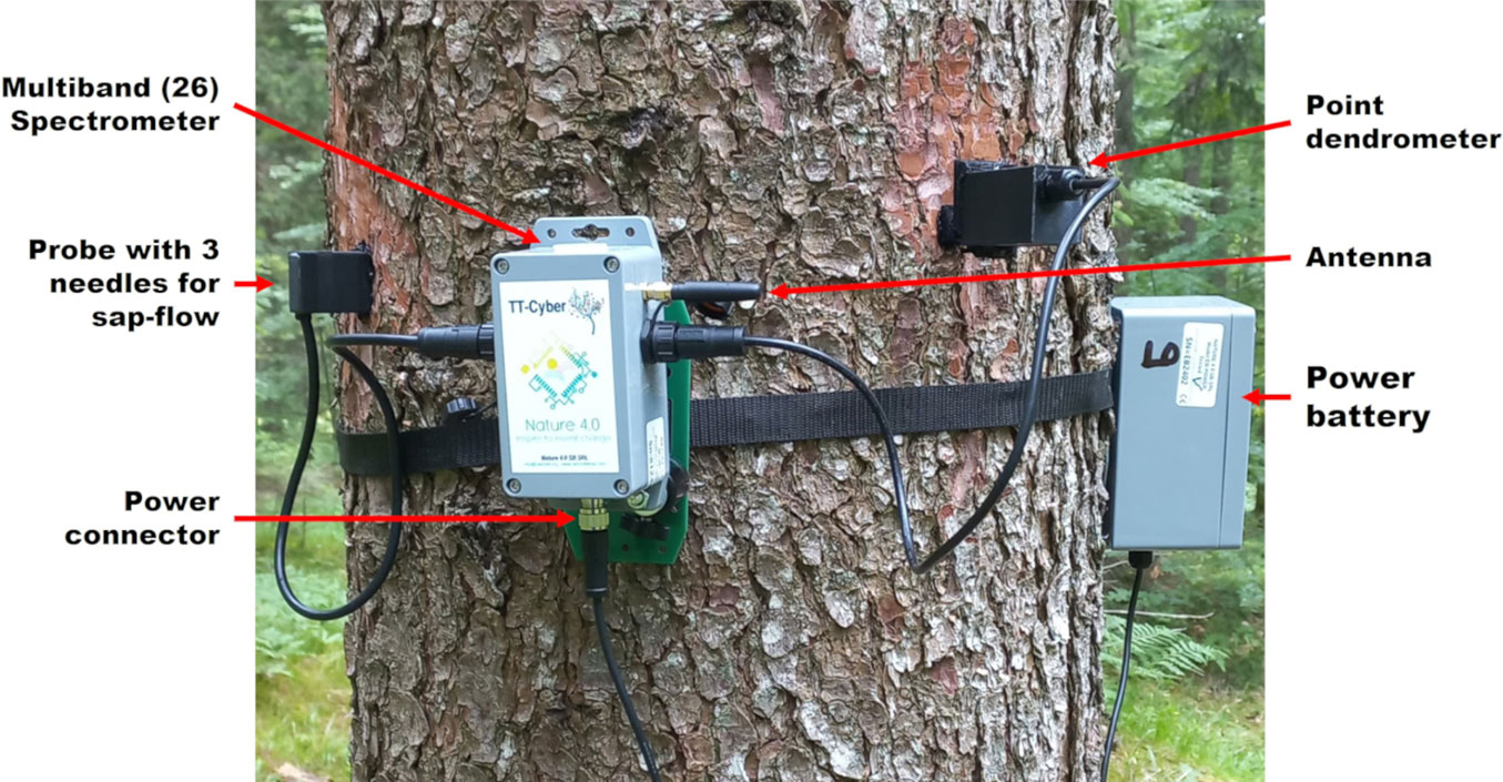
TT is a multi-sensor device integrating IoT capabilities with individual tree-scale sensing digital technologies focused on capturing tree ecophysiological parameters in quasi-real time. The device, developed in early 2018, has undergone several upgrades with a total of four versions released before the latest model named TT-Cyber. The devices rely upon IoT technologies for data transmission including the physical LoRa (long range - low frequency - low power physical layer) and communication protocols such as LoRaWan (Network protocol - Unlicensed spectrum) and NB-IOT (Licensed spectrum), allowing the collection of variables related to trees’ biological processes, such as tree health, stem radial growth, sap flow, canopy transmitted radiation spectrum, tree stem movements, air temperature and relative humidity.
Both older and more recent versions measure parameters at hourly intervals by default, though it can be customised depending on the season or monitoring objectives. The TT versions 3.0-3.4 stored data in a 3-phase configuration and operate on LoRa, with data stored in each device’s 16MB memory in the gateway (TTCloud) and in the Cloud on a third-party server. LoRa was originally selected because of its efficient technology, i.e., sub-gigahertz (868Hz) frequency, making it more resilient to changes in signal strength. In addition, it offers free unlicensed access to cellular networks, optimizing its communication parameters. As such, it is advantageous when the cell signal is lost or patchy. However, a disadvantage of the technology is the distance limitations between the gateway and the devices, which significantly impact research location and design. An upgrade to the TT-Cyber system regarding communication protocol is licensed NB-IOT capability. It essentially eliminates the requirement of a gateway to receive and send data from devices, yet maintains the local and server-based data storage options. Raw data can be downloaded from personal computers, without specific skills, even if there is a user-friendly interface to monitor pre-elaborated charts of observed variables and the level of the battery power, allowing for prompt battery replacement and avoiding gaps in the data collection. Furthermore, it allows remote interface options between individual devices and is not limited by the distance between a device and the gateway. A trade-off, however, is the requirement for moderate to strong cellular network coverage. The selection of either configuration, LoRaWan or NB-IOT, is ultimately a practical consideration dependent primarily on the location of the site.
Each sensor (Fig. 1) underwent extensive testing under laboratory and field conditions and calibration, when not provided by commercial sensors manufacturers, to translate the output digital signals into physical units.
Fig. 1 - TreeTalker’s components. Credits: Antonio Tomao. Modified by the authors.
Tab. 1reports the main characteristics of TT+ and TT-Cyber versions, as well as the most recent updates. Additional information on the TTs and preliminary results can be found in the Supplementary material.
Tab. 1 - Comparison between TT+ and TT Cyber versions.
| Parameter | TT+ versions 3.0-3.4 (LoRa) | TT Cyber (LoRaWan/NB-IOT) | ||
|---|---|---|---|---|
| Sensor | Description | Upgrades | Description | |
| Canopy transmitted radiation | Multi-band Spectrometer | Digital spectral sensor featuring 12 bands in the VIS-NIR range (450-860 nm) | Integration of 4 optical sensor chipsets | 26 bands (400-960 nm) multispectral digital sensor |
| Sap flow density |
Two-needle NTC thermistors: (heated and reference probes) | Application of the transient thermal dissipation (TTD) technique with heating and cooling phases set by default to 10 and 50 minutes | Probe with 3 needles with NTC thermistors for heat pulse velocity (HPV) technique | Probe allowing the use of both the Heat Pulse Velocity (HPV) family methods and the Thermal Dissipation-based methods. By default, the system is set to HPV. |
| Stem water content | Capacitance-based probe | Detection of relative stem water content variations | Impedance Analyzer (10 to 500 MHz) under development | |
| Stem radial growth | Infrared LED-based digital distance sensor | Radial stem growth is inferred from sensor-stem distance measured by the triangulation method | Infrared LED proximity sensor replaced by a linear magnetic encoder (LME) | Tree Stem growth measured by point dendrometer with piston movements detected by LME technology |
| Temperature and humidity |
Digital Thermohygrometer | Temperature and relative humidity | Unchanged | |
| Tree stem movements | Digital Accelerometer | Measurement of gravity components along three orthogonal axes | Unchanged | |
| Communication protocol | LoRa | Device-Gateway-Server capability | LoRaWan and NB-IOT |
Device-Gateway-Server/ Device-Server capabilities |
Building TTIN: methods and approaches
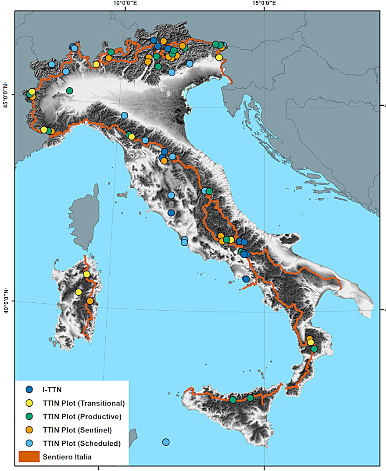
The TTIN was implemented from Northern to Southern Italy across the Alps and Apennines mountains, according to six general criteria: (i) proximity to the Grand Italian Route (Italian Alpine Club Sentiero Italia - GIR); (ii) overlapping with Italian Land Use Inventory (IUTI) grid; (iii) interconnection with existing Infrastructure and Research networks; (iv) full geographical representativeness, all Regions and Autonomous Provinces of Italy, i.e., NUTS 2 level; (v) relevance for representing interactions between climate and forest dynamics; (vi) presence of a public authority responsible for ensuring long-term management and monitoring activities (at least 10 years).
We provide below a more detailed description of the approaches adopted for selecting TTIN sites.
Proximity to Grand Italian Route
GIR is a hiking route (⇒ https://sentieroitalia.cai.it/) crossing the whole Italian peninsula and main islands, mostly winding along their mountain ranges (Alps, Apennines, and Supramonte), which metaphorically represent the spine of the country. Considering that forests cover about 37.8% of the Italian territory, and that 66% and 28% of them are located above 500 and 1.000 m a.s.l. ([18]), respectively, GIR is representative of a wide range of forest conditions in Italy. GIR was initiated in 1995 by the Club Alpino Italiano through individuating, marking, and concatenating different trail sections, an endeavour almost completed to date. GIR is 7.960 km long and it unfolds from sea level to 3.102 m at its highest point, crossing all 20 administrative regions of Italy, 16 UNESCO World Heritage sites, and numerous national and regional parks ([7]). The proximity to GIR ensures accessibility for: (i) facilitating continuous management, maintenance, and check of TTIN sites and associated devices; (ii) improving the communication and demonstration role of the network by allowing citizens to engage with scientific monitoring activities in places far from more densely populated areas ([10]). Moreover, such proximity potentially strengthens the connection and interaction among different scientific fields as GIR (and so the TTIN sites) moves across plenty of natural, cultural, and traditional landscapes in Italy (see integration of GIR within the Path of the Parks - [11]).
Overlapping with the Italian Land Use Inventory (IUTI)
The Italian land use inventory network (IUTI) is considered as a key instrument of the National Registry for forest carbon sinks and provides a statistically sound methodology for tracking changes in the land use assets in Italy since 1990 ([12], [22]). IUTI estimates the coverage of six land use categories over the national territory by visual interpretation, supports the stratified sampling design of the Italian National Forest Inventory (INFC) for carbon pools ([32]), and allows the assessment of rewilding phenomena, such as e.g., forest (and shrubs) expansion over abandoned croplands or pastures, orchards’ planting and development of built-up areas ([12]).
In this study, a buffer of 400 m (200 m per side) from GIR was created and used to select a subsample of IUTI points through a geoprocessing method. Approximately 10.500 IUTI points from the historical database were extracted and used to implement the TTIN.
Based on the combination of IUTI points and a network of forest sites already instrumented with TTs in recent years (since 2019) under various research initiatives (i.e., ITT-Net - [8]), we identified portions of the Italian territory (including not covered administrative units, i.e., Regions and Autonomous Provinces) as potential areas for ensuring full geographical representativeness of TTIN.
Clustering of forest dynamics
To ensure the continuity in monitoring activities, in each administrative unit, we reduced the total number of TTIN sites (see previous steps) limiting potential constraints that could represent hindering factors such as: the accessibility to the sites, ownership regime, management responsibility, availability of management and planning tools, potential conflicts about land use among stakeholders, commitment for mid to long term surveillance of sensors and other installations in the monitoring sites by responsible authority.
The sites were clustered into: (i) productive, (ii) transitional, and (iii) sentinel forests (Fig. 2).
Fig. 2 - A combined picture depicting real forest stands by cluster. From left to right: Ligonchio, Reggio Emilia (Sophia Djacenko); Civitella Alfedena, L’Aquila (Giovanni Santopuoli); Rasura, Sondrio (Luca Malanchini).
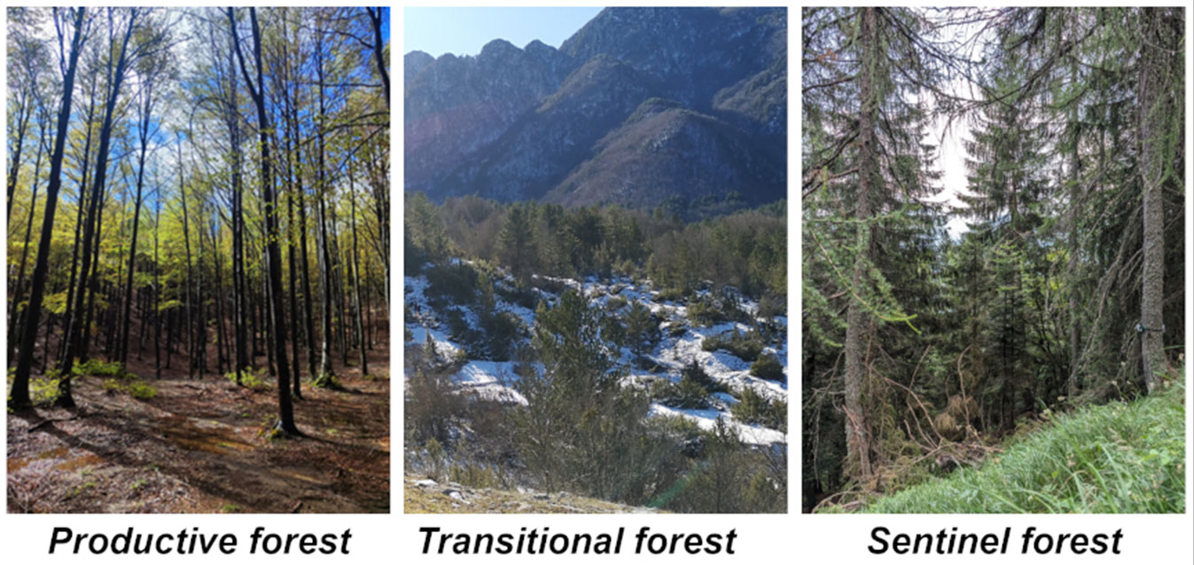
(i) Productive forests refer to mature (intermediate successional stages), ordinarily managed stands, very often located at intermediate elevation ranges (e.g., Apennine beech forests). We consider such stands as less susceptible/vulnerable to short-term to mid-term climate effects. However, their structure, components and temporal and spatial developments are strongly influenced by human activities (i.e., forestry) within a relatively short period (i.e., rotation cycle).
(ii) Transitional forests include stands undergoing successional dynamics and they are typically found in areas subject to recent rewilding processes (secondary forests; stands at early successional stages), e.g., mesophytic and thermophilous ash forests. “Transitional” is therefore explanatory of a recent or an ongoing change in land use (i.e., from other land to forest), thus excluding potential transformation of use and management within the forest land itself (e.g., conversion from coppice to high-forest). The short-term to mid-term impact of climate change on forest structure and processes of these stands might be pronounced.
(iii) Sentinel forests stands are typically located at higher elevations (in some cases, approaching the treeline). They are often representative of mature forests with a limited or cessed harvesting activity. They are highly susceptible to climatic stressors as they increasingly face drier, warmer climate conditions and longer growing seasons ([42]) or rapidly modify their composition and functionality because of climate change effects.
Tab. 2summarizes the main differences among the three clusters by considering: current successional stage; frequency and intensity of human interactions; susceptibility to climate change effects (short to mid-term changes in temperature and precipitations, drought, natural disturbances severity and frequency); ecological dynamism, i.e., speed of natural variability and change over space and time as driven by internal processes (competition, nutrient cycling) and external factors (change in land use or climate).
Tab. 2 - Summary of main characteristics of the forest clusters composing the TTIN sites.
| Cluster of forest dynamics |
Current successional stage | Human interactions | Susceptibility to climate change effects |
Ecological dynamism |
|---|---|---|---|---|
| Productive forests | Early to intermediate | High | Low to mid | Low to mid |
| Transitional forests | Early (new-growth stands) or late (over-mature stands) | Low | Mid | Low (late stages) and high (early stages) |
| Sentinel forests | Early, intermediate, or late, depending on recent development | Low | High | High |
Infrastructure and research networks involved in TTIN
The sites identified for the TTIN were chosen taking into account pre-existing networks or Research Infrastructures (RI) aimed at evaluating the impact of global changes on forest ecosystem dynamics (Tab. 3).
Tab. 3 - Research infrastructures and networks used as additional means to anchor the TTIN sites.
| Name and acronym | Brief description | Website |
|---|---|---|
| Integrated European Long-Term Ecosystem, Critical Zone, and Socio-Ecological Research (eLTER) | European research infrastructure focused on long-term, ecosystem-level observations. It integrates ecosystem, nature, and socio-ecological sciences to monitor the interactions between natural and human-driven processes across ecosystems. The network supports sustainable management and conservation by providing data and insights on biodiversity conservation, ecosystem functions and processes, and associated climate change impacts. | ⇒ https://elter-ri.eu/ |
| Integrated Carbon Observation System (ICOS) | Pan-European research infrastructure providing high-quality and standardized data on GHG concentrations and fluxes across ecosystems. It also supports climate policy by enabling detailed carbon cycle assessments and tracking the effectiveness of mitigation strategies. |
⇒ https://www.icos-ri.eu/ |
| Analysis and Experimentation on Ecosystems (AnaEE) | European research infrastructure composed of experimental platforms aimed at analysing the effects of environmental changes on ecosystems. It provides in situ modelling facilities to assess the ecosystem responses to environmental changes and develop solutions for sustainable management under future environmental scenarios. |
⇒ https://www.anaee.eu/ |
| International Co-operative Programme on Assessment and Monitoring of Air Pollution Effects on Forests (ICP Forests) | Global monitoring network focused on assessing the impacts of air pollution and other stressors on forest ecosystems. It enables the collection of long-term data on forest conditions, biodiversity conservation, and ecosystem services to inform sustainable management policies. | ⇒ https://icp-forests.net/ |
| LifeWatch | European research infrastructure targeting biodiversity and ecosystem research. It provides advanced e-tools, data, and other resources for studying biodiversity patterns, ecosystem dynamics, and ecosystem response to environmental changes, thus supporting research and decision-making for biodiversity and nature conservation. | ⇒ https://www.lifewatch.eu/ |
The availability of tree eco-physiological data in RIs sites that already provide continuous monitoring of environmental parameters could allow correlation studies useful to understand, for example, the ecosystem’s responses to changes in climate, land use, and ecosystem services. In addition, the interaction with other pre-existing RIs will allow optimizing the service maintenance and management of the equipment. TT data management will meet the FAIR principles, and data will flow in a central hub to support the advancing cross-disciplinary research through environmental domains.
Main characteristics of TTIN sites
TTIN is composed of 82 sites (for details, see Tab. S3 in Supplementary material), of which 59 are newly established and 32 come from previously existing monitoring sites already equipped with TTs ([8]). TTIN sites are distributed as follows: 32.2% of sites categorized as productive forests; 25.3% of sites categorized as sentinel forests; 10.3% of sites categorized as transitional forests; 32.2% of sites falling in more than one of the previous categories. The three most represented forest categories are: European beech (30% of sites, mostly productive forests); oaks (cork oak, Turkey oak and holm oak - 18% of sites, mostly not falling in any of the identified categories); Norway spruce (9% of sites, equally distributed between productive and sentinel forests).
Once fully operational, TTIN will implement the monitoring of about 800 trees (Fig. 3).
Fig. 3 - TTIN sites by cluster of forest dynamics, including integration with pre-existing monitoring network.
Configuration of TTIN sites and TTs installation
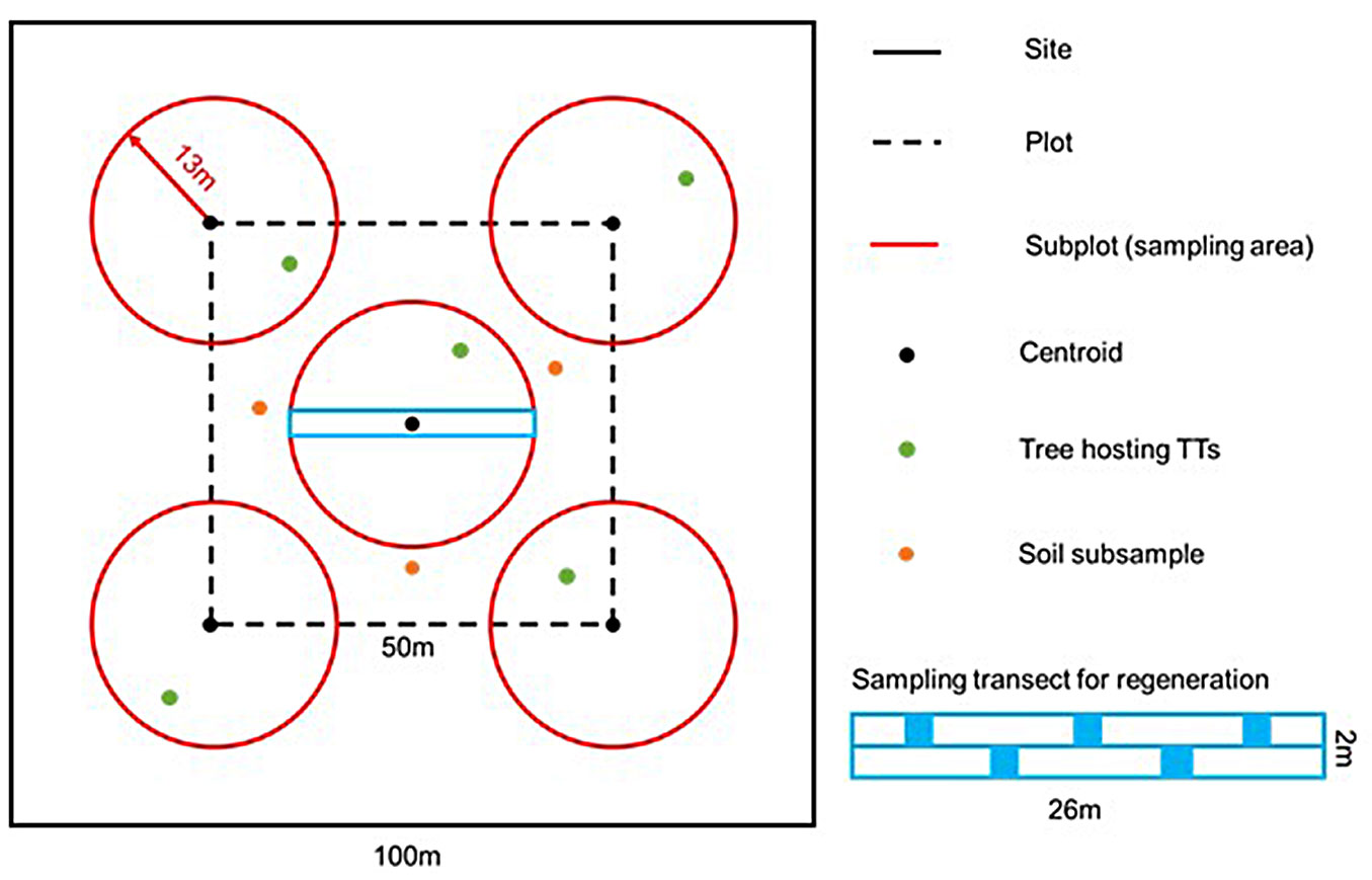
In each TTIN site, a reference area (100 × 100 m) with homogeneous forest characteristics (e.g., forest type, management system) and continuous canopy cover (absence of large canopy gaps and/or human infrastructures and manufactures) was identified, and the centre was georeferenced. Subsequently, a squared plot (50 × 50 m) was established around the georeferenced centroid and five subplots (radius = 13 m), anchored to centroid (one subplot) and vertices (four subplot), including a transect, and three subplots for topsoil measurements were identified (Fig. 4). Five trees to host TTs were identified (one per subplot). In productive and sentinel forests (see section on “forest dynamics”), such trees are selected based on dominant individuals (i.e., occupying the top canopy layer and/or representing the largest diameter class within the surveyed stand) of the target species (i.e., representing the most occurring tree species within the surveyed stand). In transitional forests, trees to host TTs were selected based on the relative share of tree species within the surveyed stand.
Fig. 4 - Schematic representation of the plots’ settings at each TTIN site.
Complementary surveys at the stand level
In each TTIN site, a series of stand-level surveys was envisaged to complement the information collected by TTs at the individual tree level. Such surveys mainly focus on key stand parameters (horizontal and vertical structure, canopy cover, etc.), forest stand’s biodiversity proxies and indicators, and soil. The aim is to enlarge the monitoring to the broader environmental context (i.e., the stand) where trees hosting TTs are located. This activity would allow a future upscaling of the correlation between individual trees’ physiology and forest stands’ development, including competition, regeneration capacity, nutrient cycling, soil fertility, structural diversity, canopy cover, etc.
Forest stand characteristics
To characterize the structure of forest stands, field data will be collected in five circular plots (i.e., inventory plots) embedded into one square hectare of forest area (i.e., TTIN sites). In each plot, four biometric variables, namely the diameter at breast height (DBH, cm), tree height (H, m), crown length (CL, m) and crown projection area (CPA, m2), for all the living trees with DBH > 7.5 cm (i.e., size threshold), will be collected. Recording the geographic position of trees should be recommended to allow spatial analysis of forest stand variables. Moreover, indications on the vitality of trees will be reported, classifying them as living, living with 1/3 of crown damaged (defoliation), living with crown damage between 1/3 and 2/3, living with crown damage >2/3, dead trees (snag in the case of trunk broken at a height > 1.30 m). NFI models ([19]) will be used to quantify the forest-growing stock and assess carbon stored in the trees. Additional data will focus on tree regeneration within a transect (26 × 2 m) north-south oriented for each plot, with the same centre as the plots. More in detail, the number of individuals, diameter, and height will be collected along the transect. Moreover, the number and height of seedlings will be recorded within five 1 m2 subplots within the transect.
Proxies for stand’s biodiversity
Within each plot, deadwood components, namely logs, stumps and dead trees ([31]) will be assessed, using 7.5 cm as diameter threshold. Besides dead trees, for which the DBH and height will be recorded, two diameters and length will be measured for each deadwood element. The decay stage will be categorized for all components into five classes ([21]).
Tree-related microhabitats (TreMs) have gained significant attention in monitoring forest biodiversity ([27], [3]). Considered as old-growth features, TreMs have been investigated to assess the naturalness of forest stands ([34], [49]) and the impact of forest management on the conservation of biodiversity ([33], [45]). More in detail, the occurrence, abundance, and richness of TreMs are indicators of potential biodiversity, representing vital habitats for several living organisms ([28]). The occurrence (presence/absence) and richness (TreMs of different types) of TreMs on each standing tree of five subplots will be observed according to the recent classification systems ([26], [28]) to determine the interactions between tree growth and vitality with biodiversity features. As suggested by Larrieu et al. ([28]), observations should be done in autumn, starting from the base of the trunk and then moving up to the crown top.
Soil sampling
The sample collected at each location comprises five topsoil (0-20 cm) subsamples that are mixed to form a single composite sample ([39]). The first subsample is taken at the precise geographical information system (GIS) coordinates of the pre-established central point. In contrast, the remaining four are taken 2 m from the central one, following the cardinal directions (North, East, South, and West). Vegetation residues, grass, and litter, when present, are removed from the surface before sampling and from the composite sample. Approximately 500 g of soil is air-dried before being transported to the laboratory for subsequent analyses. An additional 500 g of soil will be stored on ice and transported to a molecular biology laboratory for DNA analysis as part of the soil microbiome assessment. For bulk density measurements, undisturbed soil samples will be taken. Land-cover and land-use data are recorded at the same time as soil sampling; they include types of vegetation cover (e.g., coniferous trees, shrubs, lichens, and mosses) and land management (e.g., signs of grazing, ploughing, irrigation, and presence of crop residues). These data may be used to assess and monitor the effects of land cover and use on soil properties.
Discussion and conclusions
Potential for forest monitoring
TTIN settings demonstrate the potential for large-scale monitoring of forest health and functionality from individual trees to country scale in Italy. TTIN will contribute to: (i) individual tree-based, hourly monitoring of eco-physiological activities in a variety of sites representing a range of environmental settings ([51]); (ii) correlating individual tree responses with daily environmental changes (temperature, precipitation, humidity, etc.), also using external monitoring systems (e.g., Eddy Covariance towers) where available; (iii) collecting/providing scalable measures from tree to stand scale and across different stand dynamics (i.e., sentinel vs. production vs. new-growth); (iv) gathering information of combined tree growth and land use change. Real-time sensing technologies are increasingly important for forest monitoring since they provide essential environmental data for predicting vegetation and forest cover changes ([48]). Data and information collected by TTs, especially when correlated with structural attributes such as tree biomass and carbon stocks, offer an advanced step in view of obtaining a more comprehensive analysis of traditional dendrometric data and improvement of forest monitoring throughout the national or local forest inventories ([55]). Furthermore, the potential of TTs extends to real-time monitoring of forest health indicators, such as physiological stress levels, pest infestations, and overall ecosystem dynamics. Such a capillary network of IoT sensors - spread across the whole country and representative of multiple ecological dynamics - might also contribute to an integrated monitoring of spectral signals from above and below the canopy, at high temporal frequency and high spatial resolution to assess phenological phases ([44], [17], [54]). A deeper understanding of the impacts of land use transitions and individual trees and stand dynamics is ensured by the TTIN design and subsequent position of sites, anchored (or proximal) to the IUTI grid. Even out of urban areas, especially in places particularly vulnerable to natural disturbances (e.g., windthrow), real-time and individual tree-based data and information can support existing early warning systems by signalling trees’ responses to extreme climatic events and forest health issues (e.g., Wireless Sensors Network, WSN - [53]).
Potential for research and outreach
TTIN makes a step forward in forest ecology, in particular concerning the understanding of tree-based mechanisms of physiological feedback to environmental changes. Real-time data and information on forest health, vitality, and resilience from TTs will be integrated within the currently existing monitoring networks (e.g., NFI, other research infrastructures - Tab. 3). This comprehensive array of information will enable researchers to examine the immediate effects of combined environmental factors on tree growth and productivity. These advancements allow the upscaling of tree-based surveys, providing insights into broader-scale forest dynamics and resilience to changing climatic conditions and management practices. Moreover, complementary field surveys will provide several parameters on stand structure, soil, and biodiversity features to correlate with tree-based physiological data. This will facilitate a full-scope representation of environmental features at the stand scale. These characteristics can then be used to assess the impact of combined management and climate on tree growth, competition, establishment, and regeneration. The use of real-time, large-scale data within TTIN has indeed significant outcomes and implications, such as the possibility of data-driven model development, the inference of forest attributes, as well as performing advanced studies in macro-ecology ([52]).
Despite several examples exist on the integration of field data with remote sensing information ([44], [9], [16], [1]), a remaining challenge lies in how to scale up local systems, such as TTs, and integrate them into a broader monitoring framework. Indeed, some research and implementation gaps still remain about: (i) applying IoT devices (TTs) in different environmental settings, including tree species and stand structures to scale up measurements of tree-environment interactions, thus reflecting the dynamics and geography of physiological mechanisms and processes; (ii) creating local (e.g., landscape) and/or land use-specific (e.g., urban areas) databases on annual and seasonal indicators on tree responses to climate stressors; (iii) improving current monitoring systems towards a better understanding of early signs of alteration of forest ecosystems’ development (i.e., far enough from tipping points), including the effects of warmer and drier climate on mortality and growing capacity; (iv) integrating new technologies (e.g., IoT) for collecting modular and scalable site-specific data sources, allowing long-term predictions and improving environmental stratification within currently available monitoring frameworks and forest management and planning schemes.
TTIN is also a powerful means for communicating science. Sites are distributed over GIR, they are positioned in accessible stands, and can therefore be visited by a potentially large number of people. For this reason, the TTIN network also lends itself to citizen science activities. Moreover, TTIN sites are equipped with billboards, labels, and other communication material describing inter alia the overall network (e.g., main parameters collected, list of partners, and responsible bodies), main implications, and relevance at various geographical scales. Each tree hosting TTs also has a small label describing the species, its ecology and physiology, and the main reasons behind its selection as a candidate for analysis. A QR code, or a URL for a direct link to the website, is also provided to facilitate communication with the general public. Such communication and information assets might reach a broader target audience of interested people and a greater understanding of the research activities being carried out, including a raised public awareness of positive implications for local communities or tourists.
Potential limitations and challenges
Despite the TTIN represents a high-quality monitoring system, and numerous efforts have been made to improve the efficiency in data collection and elaborations, some challenges and limitations are still evident. For example, in some remote forest areas, the signal for connection is lacking or extremely weak, thus hindering the data uploading capacity. This requires an accurate selection of the site before installing the instruments. Nevertheless, it is always possible to download the data collected by the sensors directly in the field. One challenging aspect concerns the risk of damages due to environmental hazards and wildlife; in these cases, the replacement of sensors is necessary to avoid gaps in the data collection. An automatic alert of a malfunctioning sensor is recommended for preventing or limiting the gaps in collecting data. Moreover, periodic site inspections and maintenance are necessary for battery replacement. Further efforts are required to improve the pre-elaboration as well as the harmonization of information collected in a database with common forest attributes and/or indicators. These actions are also important for making communication with the general public more effective.
Acknowledgements
The present work has received funding by: GEOSCIENCES IR - A Research Infrastructure for the Italian Geological Surveys Network, funded by European Union - NextGenerationEU - Mission 4 “Education and Research” - Component 2 “From Research to Business” - Investment 3.1 “Fund for the realization of an integrated system of research and innovation infrastructures” - Project IR0000037 - GeoSciences IR - CUP I53C22000800006; National Biodiversity Future Center (NBFC), project funded under the National Recovery and Resilience Plan (NRRP), Mission 4 Component 2 Investment 1.4 - Call for tender No. 3138 of 16 December 2021, rectified by Decree n.3175 of 18 December 2021 of the Italian Ministry of University and Research funded by the European Union - NextGenerationEU, Award Number Project code CN_00000 033, Concession Decree No. 1034 of 17 June 2022 adopted by the Italian Ministry of University and Research, CUP H73C220003 00001, Project title “National Biodiversity Future Center - NBFC”; ITINERIS, Italian Integrated Environmental Research Infrastructures System (D.D. n. 130/2022 - CUP B53C22002150006) Funded by EU - Next Generation EU PNRR- Mission 4 “Education and Research” - Component 2: “From research to business” - Investment 3.1: “Fund for the realisation of an integrated system of research and innovation infrastructures”; AGRITECH - National research centre for agricultural technologies, Carbon and water cycles interactions during drought and their impact on WAter and ForEst Resources in the Mediterranean region (WAFER) technologies (CN00000022 - SP. 4 T, CUP C93C22002790001SAC.AD002. 173.021, CUP C93C22002790001); AGRITECH - National research centre for agricultural technologies, Multifunctional and resilient agriculture and forestry systems for the mitigation of climate change risks (CN000 00022 - SP. 4 T; CUP: C93C220027 90001; Task 4.1.3); MIUR Project (PRIN 2020) “Unravelling interactions between WATER and carbon cycles during drought and their impact on water resources and forest and grassland ecosySTEMs in the Mediterranean climate” - WATERSTEM DCN_0000 0033D.D. n. 130/2022 - CUP B53C2200215 0006 protocol code: 20202WF53Z and “WAFER” @CNR (Consiglio Nazionale delle Ricerche); the Open-Earth-Monitor Cyberinfrastructure project funded from the European Union’s Horizon Europe research and innovation programme under grant agreement No. 101059548.
The authors wish to thank people contributing to the field work such as: Silvio Oggioni, Lorenzo Rossi, Luca Malanchini, Alberica Orsa Maria Mion, Michel Saini (Università degli Studi di Milano); Luca Cadez, Lorenzo Maria Sabbadini, Mauro Lo Cascio; Raffaella Dibona (University of Padua); Concetta Lisella, Diana Alfieri, Pierdomenico Spina (Università degli Studi del Molise); site managers and other public bodies supporting the TTIN establishment: ERSAF Lombardia, Azienda Speciale Silvo Pastorale di Troina, Parco Nazionale dell’Appennino Tosco-Emiliano, Parco Nazionale d’Abruzzo, Lazio e Molise, Parchi delle Madonie e dei Nebrodi, Parco Nazionale dei Monti Sibillini, Regione Autonoma Friuli Venezia Giulia, Carabinieri Forestali di Tarvisio, Reparto Carabinieri Biodiversità di Vallombrosa, Reparto Carabinieri Biodiversità di Isernia, Unione Comuni Valdarno e Valdisieve, Parco Nazionale del Vesuvio e Ufficio Territoriale Carabinieri per la Biodiversità di Caserta.
The authors also acknowledge the partners of the PRIN ITT-Net for making previous TTs’ sites available for integration into TTIN.
References
CrossRef | Gscholar
CrossRef | Gscholar
CrossRef | Gscholar
Gscholar
CrossRef | Gscholar
CrossRef | Gscholar
Online | Gscholar
Gscholar
Gscholar
CrossRef | Gscholar
Gscholar
Gscholar
Gscholar
CrossRef | Gscholar
CrossRef | Gscholar
CrossRef | Gscholar
CrossRef | Gscholar
CrossRef | Gscholar
CrossRef | Gscholar
CrossRef | Gscholar
CrossRef | Gscholar
Authors’ Info
Authors’ Affiliation
Sophia Djacenko
Giorgio Vacchiano 0000-0001-8100-0659
Università degli Studi di Milano (Italy)
Claudio Donati 0000-0001-8688-1651
Damiano Gianelle 0000-0001-7697-5793
Stefano Larsen 0000-0002-6774-1407
Massimo Pindo 0000-0002-8516-9010
Erika Stefani 0000-0002-5114-5387
Research and Innovation Centre, Fondazione Edmund Mach (Italy)
Davide Ascoli 0000-0002-2671-5122
Michele Freppaz 0000-0002-4290-6850
Fabio Meloni 0000-0002-4643-8679
Renzo Motta 0000-0002-1631-3840
Università degli Studi di Torino (Italy)
Claudio Donati 0000-0001-8688-1651
Tommaso La Mantia 0000-0002-7494-742X
Stefano Larsen 0000-0002-6774-1407
NBFC - National Biodiversity Future Center (Italy)
Shahla Asgharinia 0000-0002-6210-1232
Francesco Renzi 0000-0001-8460-1935
Riccardo Valentini 0000-0002-6756-5634
Università degli Studi della Tuscia (Italy)
Antonio Tomao 0000-0001-6656-400X
Università degli Studi di Udine (Italy)
Simona Castaldi 0000-0003-3937-8169
Jerzy Piotr Kabala 0009-0007-7713-484X
Francesco Niccoli 0000-0001-5761-2604
Università degli Studi della Campania Luigi Vanvitelli (Italy)
Claudia Cocozza 0000-0002-0167-8863
Università degli Studi di Firenze (Italy)
Samuele Pellizzari 0009-0005-8095-1432
Università degli Studi di Padova (Italy)
Giovanna Sala 0000-0002-4813-7052
Università degli Studi di Palermo (Italy)
Costantino Battista Sirca 0000-0001-7605-5700
Donatella Spano 0000-0002-5661-0241
Università degli Studi di Sassari (Italy)
Donatella Spano 0000-0002-5661-0241
CMCC Foundation - Euro-Mediterranean Centre on Climate Change (Italy)
Enrico Tomelleri 0000-0001-6546-6459
Libera Università di Bolzano (Italy)
Corresponding author
Paper Info
Citation
Vizzarri M, Marchesini Belelli L, Piermattei A, Santopuoli G, Ottaviano M, Parisi F, Yates J, Asgharinia S, Alberti G, Antonucci S, Ascoli D, Battipaglia G, Bizzarri A, Castagneri D, Castaldi S, Cocozza C, Dionigi M, Djacenko S, Donati C, Freppaz M, Garfì V, Gentile C, Gianelle D, Giusti R, Iannuccilli M, Kabala JP, La Mantia T, Larsen S, Lasserre B, Lombardi F, Magnani F, Massari C, Matteucci G, Mazzenga F, Meloni F, Messeri A, Montella M, Niccoli F, Pellizzari S, Pindo M, Renzi F, Sala G, Salbitano F, Sammarone L, Sirca CB, Spano D, Stefani E, Tomao A, Motta R, Tognetti R, Tomelleri E, Vacchiano G, Valentini R, Marchetti M (2025). Hearing nature’s heartbeat: towards large-scale real-time forest monitoring network in Italy. iForest 18: 202-211. - doi: 10.3832/ifor4830-018
Academic Editor
Marco Borghetti
Paper history
Received: Feb 13, 2025
Accepted: Jun 05, 2025
First online: Aug 09, 2025
Publication Date: Aug 31, 2025
Publication Time: 2.17 months
Copyright Information
© SISEF - The Italian Society of Silviculture and Forest Ecology 2025
Open Access
This article is distributed under the terms of the Creative Commons Attribution-Non Commercial 4.0 International (https://creativecommons.org/licenses/by-nc/4.0/), which permits unrestricted use, distribution, and reproduction in any medium, provided you give appropriate credit to the original author(s) and the source, provide a link to the Creative Commons license, and indicate if changes were made.

Web Metrics
Breakdown by View Type
Article Usage
Total Article Views: 12044
(from publication date up to now)
Breakdown by View Type
HTML Page Views: 6029
Abstract Page Views: 3227
PDF Downloads: 2636
Citation/Reference Downloads: 6
XML Downloads: 146
Web Metrics
Days since publication: 335
Overall contacts: 12044
Avg. contacts per week: 251.67
Article Citations
Article citations are based on data periodically collected from the Clarivate Web of Science web site
(last update: Mar 2025)
(No citations were found up to date. Please come back later)
Publication Metrics
by Dimensions ©
Articles citing this article
List of the papers citing this article based on CrossRef Cited-by.
Related Contents
iForest Similar Articles
Research Articles
Links between phenology and ecophysiology in a European beech forest
vol. 8, pp. 438-447 (online: 15 December 2014)
Editorials
Adaptation of forest ecosystems to air pollution and climate change: a global assessment on research priorities
vol. 4, pp. 44-48 (online: 05 April 2011)
Commentaries & Perspectives
Availability, accessibility, quality and comparability of monitoring data for European forests for use in air pollution and climate change science
vol. 4, pp. 162-166 (online: 11 August 2011)
Editorials
COST Action FP0903: “Research, monitoring and modelling in the study of climate change and air pollution impacts on forest ecosystems”
vol. 4, pp. 160-161 (online: 11 August 2011)
Review Papers
Impacts of climate change on the establishment, distribution, growth and mortality of Swiss stone pine (Pinus cembra L.)
vol. 3, pp. 82-85 (online: 15 July 2010)
Research Articles
Predicting the effect of climate change on tree species abundance and distribution at a regional scale
vol. 1, pp. 132-139 (online: 27 August 2008)
Research Articles
Extreme climatic events, biotic interactions and species-specific responses drive tree crown defoliation and mortality in Italian forests
vol. 17, pp. 300-308 (online: 30 September 2024)
Research Articles
Response of juvenile progeny of seven forest tree species and their populations to simulated climate change-related stressors, heat, elevated humidity and drought
vol. 11, pp. 374-388 (online: 15 May 2018)
Editorials
Future monitoring and research needs for forest ecosystems in a changing environment: an introduction
vol. 2, pp. 54-55 (online: 21 January 2009)
Research Articles
Climate impacts on tree growth in a Neotropical high mountain forest of the Peruvian Andes
vol. 13, pp. 194-201 (online: 19 May 2020)
iForest Database Search
Search By Author
- M Vizzarri
- L Marchesini Belelli
- A Piermattei
- G Santopuoli
- M Ottaviano
- F Parisi
- J Yates
- S Asgharinia
- G Alberti
- S Antonucci
- D Ascoli
- G Battipaglia
- A Bizzarri
- D Castagneri
- S Castaldi
- C Cocozza
- M Dionigi
- S Djacenko
- C Donati
- M Freppaz
- V Garfì
- C Gentile
- D Gianelle
- R Giusti
- M Iannuccilli
- JP Kabala
- T La Mantia
- S Larsen
- B Lasserre
- F Lombardi
- F Magnani
- C Massari
- G Matteucci
- F Mazzenga
- F Meloni
- A Messeri
- M Montella
- F Niccoli
- S Pellizzari
- M Pindo
- F Renzi
- G Sala
- F Salbitano
- L Sammarone
- CB Sirca
- D Spano
- E Stefani
- A Tomao
- R Motta
- R Tognetti
- E Tomelleri
- G Vacchiano
- R Valentini
- M Marchetti
Search By Keyword
Google Scholar Search
Citing Articles
Search By Author
- M Vizzarri
- L Marchesini Belelli
- A Piermattei
- G Santopuoli
- M Ottaviano
- F Parisi
- J Yates
- S Asgharinia
- G Alberti
- S Antonucci
- D Ascoli
- G Battipaglia
- A Bizzarri
- D Castagneri
- S Castaldi
- C Cocozza
- M Dionigi
- S Djacenko
- C Donati
- M Freppaz
- V Garfì
- C Gentile
- D Gianelle
- R Giusti
- M Iannuccilli
- JP Kabala
- T La Mantia
- S Larsen
- B Lasserre
- F Lombardi
- F Magnani
- C Massari
- G Matteucci
- F Mazzenga
- F Meloni
- A Messeri
- M Montella
- F Niccoli
- S Pellizzari
- M Pindo
- F Renzi
- G Sala
- F Salbitano
- L Sammarone
- CB Sirca
- D Spano
- E Stefani
- A Tomao
- R Motta
- R Tognetti
- E Tomelleri
- G Vacchiano
- R Valentini
- M Marchetti
Search By Keywords
PubMed Search
Search By Author
- M Vizzarri
- L Marchesini Belelli
- A Piermattei
- G Santopuoli
- M Ottaviano
- F Parisi
- J Yates
- S Asgharinia
- G Alberti
- S Antonucci
- D Ascoli
- G Battipaglia
- A Bizzarri
- D Castagneri
- S Castaldi
- C Cocozza
- M Dionigi
- S Djacenko
- C Donati
- M Freppaz
- V Garfì
- C Gentile
- D Gianelle
- R Giusti
- M Iannuccilli
- JP Kabala
- T La Mantia
- S Larsen
- B Lasserre
- F Lombardi
- F Magnani
- C Massari
- G Matteucci
- F Mazzenga
- F Meloni
- A Messeri
- M Montella
- F Niccoli
- S Pellizzari
- M Pindo
- F Renzi
- G Sala
- F Salbitano
- L Sammarone
- CB Sirca
- D Spano
- E Stefani
- A Tomao
- R Motta
- R Tognetti
- E Tomelleri
- G Vacchiano
- R Valentini
- M Marchetti
Search By Keyword


