Fire influence on forest cover in the Caparaó microregion, state of Espírito Santo, Brazil
iForest - Biogeosciences and Forestry, Volume 18, Issue 5, Pages 267-272 (2025)
doi: https://doi.org/10.3832/ifor4608-018
Published: Oct 14, 2025 - Copyright © 2025 SISEF
Research Articles
Abstract
Forests play a crucial role in biodiversity conservation, climate regulation, and the provision of essential ecosystem services. However, their resilience has been compromised by disturbances such as wildfires, which cause vegetation loss, habitat fragmentation, and disruptions of ecological cycles. Understanding the relationship between fire and forest cover is crucial for guiding conservation strategies, especially in biodiversity-rich regions like the Caparaó microregion in the state of Espírito Santo (Brazil). This study examined the impact of wildfires on forest cover between 2012 and 2021, integrating remote sensing data, meteorological information, and geoprocessing tools. The results indicated that approximately 43.92 km2 were affected by fire, with 1.78% (0.78 km2) of the impacted areas covered by forests. A strong positive correlation (r = 0.837) was found between fire occurrence and forest cover loss, indicating that increased fire activity is associated with a reduction in forest area. A moderate positive correlation (r = 0.422) was observed between maximum temperature and burned area, which may indicate a trend of increasing fire risk as temperatures rise. It is important to note that the increase in forest cover observed during the study period primarily occurred in areas distinct from those affected by fire, suggesting natural regeneration or reforestation processes in other parts of the landscape. This scenario highlights the importance of public policies that prioritize continuous monitoring and fire prevention, especially given the projected increase in extreme climatic events, such as severe droughts, expected over the coming decades. The results of this study provide useful insights for land-use planning and the development of restoration and conservation strategies for the Atlantic Forest and similar ecosystems.
Keywords
Burn Analysis, Ecosystem Dynamics, Conservation Strategies, Remote Sensing, Atlantic Forest, Wildfire, Forest Degradation, Reforestation
Introduction
The degradation and fragmentation of Brazilian forest ecosystems, driven by increasing population demands and economic pressures, have led to a scarcity of primary forests over time ([18]), with the Atlantic Forest being the most affected biome. The Atlantic Forest biome is a global biodiversity hotspot, spanning 17 states and currently housing 72% of Brazil’s population ([39], [46]).
The expected fire regime in the Atlantic Forest is minimal or nonexistent, as fire is neither a natural nor adaptive factor within this biome. Fire occurrences are generally linked to human activities, such as land clearing for agriculture, and act as external disturbances that degrade the ecosystem rather than promoting evolutionary adaptations of species to fire ([4]).
Between 2019 and 2020, ten states within the Atlantic Forest region experienced a decline in forest cover, attributed to factors such as natural resource exploitation, urbanization, and wildfires ([46]). Despite these challenges, some well-preserved forest remnants remain, such as the Caparaó National Park (PARNA Caparaó), which contains highly preserved areas and a notable number of endemic species from representative families of the Brazilian flora ([6]).
The Caparaó region is an area of great environmental relevance, rich in biodiversity and extensive forest cover. The occurrence of wildfires can significantly impact both vegetation cover and biodiversity in this region, directly affecting the integrity of ecosystems. Understanding these impacts is essential for evaluating the current and future responses of tropical forests to fire ([9]).
The intense fragmentation of the Atlantic Forest has increased the biome’s vulnerability to wildfires ([45]). The reduction in vegetation cover, the increase in fragment edges, and the proximity to anthropic areas favor fire spread, intensifying the frequency and severity of wildfires ([19]). These processes, driven by human activities, compromise natural regeneration and may accelerate the transition of the forest into more open systems, such as savanna-like formations ([41]).
In this context, wildfires have become a major driver of forest fragment degradation, causing direct destruction and disrupting the ecological dynamics of affected areas ([17]). Although the use of fire is associated with traditional anthropogenic practices, previous studies indicate that climate change has also contributed to the increasing frequency and intensity of wildfires through the extension of dry periods and rising temperatures ([2], [25]). Therefore, both anthropogenic pressures and climatic conditions must be considered when assessing fire regimes and their effects on the Atlantic Forest.
Recent extreme climatic events, such as intense heatwaves, prolonged droughts, and record-breaking temperatures, have contributed to increasing the vulnerability of forest ecosystems ([27], [35], [32]). Such events, associated with unpredictable rainfall patterns, are creating conditions that foster increasingly severe wildfires ([14]). This underscores the relevance of the climate crisis for decision-makers, as some climate impacts are now considered irreversible ([23]).
Forests in the state of Espírito Santo are particularly susceptible to these extreme events, as evidenced by the high percentage of areas classified as high to extreme fire risk (over 78%) due to climatic factors ([10]). Rising temperatures and altered precipitation patterns increase the risk of wildfires, requiring proactive conservation efforts to maintain ecosystem balance ([13]).
In this scenario, analyzing temperature trends and burned areas becomes essential to understand how climate variations have influenced the severity and extent of fires in the region. Furthermore, recognizing these climatic pressure factors helps in understanding and anticipating future risks in climate change scenarios ([24]), and contributes to assessing the vulnerability of local forests, thereby supporting the development of more effective management strategies in the face of climate change.
This study aims to analyze the relationship between fire occurrence and forest cover in the South Caparaó region of Espírito Santo by mapping and quantifying burned areas from 2012 to 2021, along with their overlap with forest cover. To this end, Pearson’s correlation was applied to evaluate the relationships between wildfires and forest cover loss, as well as between maximum temperature and burned area. This coefficient helps in identifying the positive or negative relationship between two linear variables. In addition, this study aims to investigate how climatic variables, particularly temperature, affect fire patterns in the region and assess their impact on wildfire patterns.
Materials and methods
Given the significant increase in extreme weather events and the intensification of the climate crisis over the past decade ([26], [49]), the period from 2012 to 2021 was selected for analysis. This timeframe represents a critical period during which climate change has had a direct and escalating impact on wildfires ([3]), underscoring the need for a detailed study of this period.
Study area
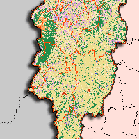
The state of Espírito Santo (ES), located in southeastern Brazil, spans an area of 46,074,448 km2 and has a population of 4,108,508 inhabitants ([20]). The Espírito Santo State is divided into ten microregions ([16]); in this study, we focus on the Caparaó microregion, located in the southern portion of Espírito Santo. This area is characterized by mountainous terrain and includes the Caparaó Mountain Range, a critical zone for preserving the Atlantic Forest in Espírito Santo ([21]).
The Caparaó microregion comprises the municipalities of Alegre, Bom Jesus do Norte, Dores do Rio Preto, Divino de São Lourenço, Guaçuí, Ibatiba, Ibitirama, Irupi, Iúna, Muniz Freire, and São José do Calçado (Fig. 1). The microregion covers an area of approximately 3,987.88 km2, which corresponds to 8.31% of the state’s territory, and about 50% of the population lives in rural areas ([28]).
Fig. 1 - The study area, Caparaó microregion, state of Espírito Santo (Brazil).
The average annual temperature in this region ranges from 16 °C to 22 °C, with peak temperatures between 24 °C and 29 °C during the hottest seasons. The area features a varied altitude, ranging from 300 to 2900 m a.s.l., and receives an average annual precipitation of 1200 to 1500 mm ([28]). Vegetation in the region is part of the Atlantic Tropical Domain, characterized by semideciduous seasonal forests ([15]).
Acquisition data
Territorial limits data
Data for national, state, and municipal borders were obtained from the database provided by the Brazilian Institute of Geography and Statistics ([20]). The delimitation of the Caparaó region followed the classification from the State Institute of Environment and Water Resources (IEMA), specifically Class 6 in Geobases ([16]). The municipalities within the Caparaó microregion were extracted from the IBGE vector file. Data processing was conducted using QGIS v. 3.28.4, a free and open-source software ([36]).
Burned coverage data
Data on burned areas were acquired from the MapBiomas Fire product, Collection 2.0 ([29]), which maps fire scars across Brazil. The area corresponding to Espírito Santo was selected, using Annual Burned Coverage data. Images from 2012 to 2021 were downloaded for subsequent data processing.
Land use and occupation data
Land Use and Land Cover data were sourced from Collection 7.1 of Mapbiomas ([30]). The state of Espírito Santo was selected, and images with “coverage” data for the years 2012 to 2021 were downloaded for further processing.
Meteorological data
Meteorological data were obtained from the Brazilian Daily Weather Gridded Data collection ([48]) via Google Earth Engine™, and processed in QGIS v. 3.28.4. Average values were extracted for precipitation, maximum and minimum temperatures, solar radiation, and relative humidity in the study area. Values for 2021 were estimated by averaging data from 2012 to 2020 to compensate for limitations in the data series.
Data processing
Burned coverage data
The previously downloaded raster scenes were imported into QGIS and clipped to the Caparaó microregion study area shapefile. Layers were then vectorized, converting them from raster to vector format, and classes were dissolved. An attribute named “year” was assigned to all vector layers, which were subsequently merged based on this attribute, creating a single shapefile containing burned coverage (BC) data for each year.
Land use and occupation data
Raster scenes representing land use and land cover (LUC) were imported into QGIS and clipped to the study area shapefile, generating raster images for the Caparaó microregion. Layers were vectorized, and polygons with the same LUC class were merged. Forest classes were then isolated for the specified years. A symmetric difference operation compared the forest area between 2012 and 2021 to assess changes (losses and gains) in forest cover over the period ([37]). This method identifies and quantifies areas of change in forest cover, excluding areas that remained constant.
Land use vs. burned coverage
Following the identification of changes in forest cover and the mapping of burned areas, an “intersection” operation was performed in QGIS. This step aimed to evaluate areas of forest gain or loss that overlapped with burned areas, comparing data on forest cover loss or gain with burned coverage.
The “intersection” tool extracts overlapping features from the input and overlay layers ([38]). The input layer utilized was the burned area data for a period of 10 years. As the overlay layer, data on forest losses during the specified period were used. The output layer at this stage allows for the identification of areas where forest losses or gains overlap with fire-affected areas, facilitating the identification of forested areas impacted by fire.
Statistical analysis
A Pearson’s correlation analysis was conducted to assess the relationships between wildfires and forest cover loss, as well as between maximum temperature and burned area. Pearson’s correlation coefficient measures the linear relationship between two variables. A value close to +1 indicates a strong positive correlation, meaning that a one-unit change in variable X results in a similar change in variable Y ([33], [11]). In this study, the correlation between the wildfire-affected area and forest cover loss was examined to identify potential associations between the extent of burned areas and the reduction in forest cover. Similarly, the correlation between maximum temperature and burned area allowed for the examination of the influence of extreme temperatures on the extent of areas affected by fire.
In addition to the correlation analysis, a scatter plot was generated to illustrate the relationships between wildfires and forest cover loss, as well as between maximum temperature and burned area, providing a clear visualization of observed patterns and trends. This analysis was conducted using the R language within the RStudio software ([40]).
Results and discussion
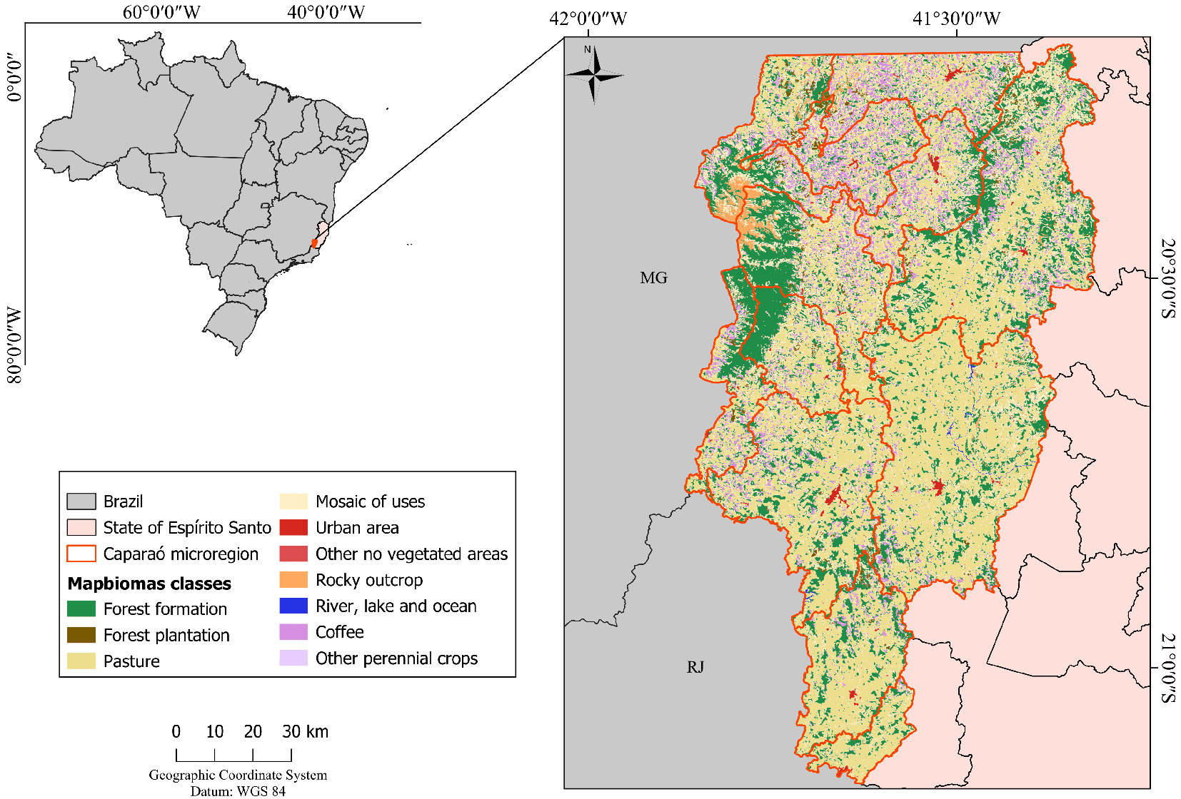
The Caparaó microregion encompasses a total area of 3,987.89 km2, of which approximately 43.92 km2 (1.10%) was affected by fire between 2012 and 2021. Of the burned areas, only 0.78 km2 (1.78%) overlapped with regions classified as forest cover (Fig. 2A), indicating that most fire events occurred in non-forested landscapes, such as pastures or agricultural lands. Although the proportion of forested areas affected by fire was relatively low, this value becomes significant when analyzed in the context of land-use and land-cover dynamics. During this period, forest cover in the microregion increased substantially from 894,659 km2 in 2012 to 983.328 km2 in 2021, according to Mapbiomas data ([29]). Therefore, even small-scale disturbances in forested areas may compromise the progress achieved in ecological restoration and native vegetation conservation efforts in the region.
Fig. 2 - (A) Spatial distribution of burned areas and areas of forest formation (FF) increment and loss between 2012 and 2021 across the entire Caparaó microregion, state of Espírito Santo, Brazil; (B) temporal evolution of burned areas (km2); and (C) changes in forest formation (FF) occurring only within the boundaries of burned areas. Note: (B) and (C) refer exclusively to the area affected by fire, as outlined in Fig. 2A.
This suggests that even small burned areas can represent a significant portion of the remaining forest fragments. Notably, the year 2015 recorded the largest burned area per km2 in Espírito Santo (Fig. 2B), coinciding with the largest forest loss observed during the study period (Fig. 2C). Despite these localized losses, an overall increase in forest cover was observed in areas unaffected by fire, possibly due to natural regeneration or changes in land use elsewhere in the landscape.
It is worth noting that the areas affected by fires and those showing forest cover expansion do not necessarily overlap. Through the intersection analysis between burned area data and changes in forest cover, it was possible to identify that, while some regions in the Caparaó microregion experienced vegetation loss due to fire, forest cover gains predominantly occurred in other areas that were not affected by fires, likely driven by natural regeneration processes and restoration programs such as Reflorestar ([42]). This result highlights the spatially distinct dynamics of forest loss and gain, indicating that the observed forest increase was not a direct response to fire events, but rather the outcome of other initiatives and favorable local conditions for recovery.
According to data from the National Institute for Space Research (INPE), 940 active fire detections were recorded in Espírito Santo in 2015, the highest number in the 2014-2019 period. These detections refer to satellite-identified thermal anomalies associated with active fires (Queimadas Program - INPE). This peak coincided with a period of significantly reduced precipitation in the state ([22]), particularly affecting the dry season months. This correlation suggests that prolonged drought conditions may have contributed to the increased fire activity observed that year. Fire risk is closely linked to rainfall patterns ([12]). Drought was further intensified by the 2015 El Niño phenomenon, which raised temperatures in Brazil, thereby increasing thermal stress and amplifying fire severity in certain regions. This event also heightened concerns and discussions on deforestation and tropical forest protection ([1], [31]).
Restoration efforts have helped to counterbalance some of these adverse effects. The increase in forest areas (Fig. 2C) is primarily due to the Reflorestar Program, which has played a crucial role in restoring forest cover in the Caparaó microregion, where 2879.13 ha have been included in recovery initiatives ([42]). Beyond financial support, the program provides technical assistance and promotes sustainable practices, benefitting rural producers and encouraging responsible land use ([43], [47], [42]).
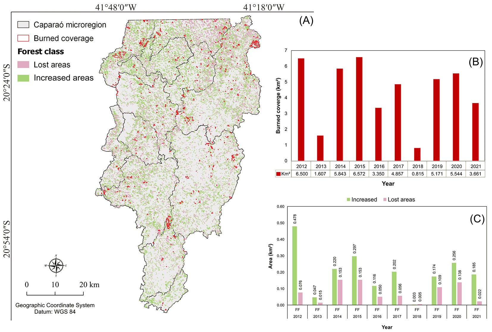
The Pearson’s correlation (r) between wildfires and forest cover loss was 0.837 (p-value = 0.0025), indicating a strong positive relationship as commonly interpreted for correlation coefficients above 0.7, where variables increase together in a consistent linear pattern ([8], [5]), with forest cover loss increasing in tandem with the extent of wildfire-affected area (Fig. 3A). This significant correlation highlights the considerable impact of wildfires on forest cover loss in the Caparaó microregion. Furthermore, the correlation between maximum temperature and burned area yielded an r-value of 0.422 (p-value = 0.2249 - Fig. 3B). This suggests a moderate positive relationship, typically applied to coefficients between 0.3 and 0.49 ([8]), indicating that while temperature may influence forest cover loss, other factors might be more directly associated with the forest loss observed in the region.
Fig. 3 - Correlation between forest loss (km2) and (A) forest fires (km2) and (B) maximum temperature (°C) in the Caparaó microregion, state of Espírito Santo, Brazil.
The strong correlation between wildfires and forest cover loss (r = 0.837) underscores the importance of integrating fire prevention into conservation strategies. Educational campaigns and community-based initiatives, particularly in schools and communities near Caparaó National Park, can be highly effective in mitigating fire impacts ([17], [34]).
While the correlation between maximum temperature and forest cover loss was moderate and not statistically significant (r = 0.422, p = 0.2249), the results suggest that drier and warmer conditions increase fire risk, particularly during events such as the 2015 El Niño, which heightened fire susceptibility in southeastern Brazil ([44], [7]). Overall, proactive prevention and robust forest monitoring are crucial for mitigating wildfires and conserving forest cover in the Caparaó microregion.
The historical data from 2012 to 2021 shows that maximum temperatures remained relatively stable through time, averaging around 40 °C and showing a peak in 2015 (Fig. 4). Annual precipitation, however, fluctuated more significantly, with the lowest rainfall recorded in 2015, the same year that experienced the highest maximum temperature. This combination of high temperature and low rainfall in 2015 led to extremely arid conditions, increasing the fire risk in the region.
Fig. 4 - Trends in precipitation (ppt) and maximum (Tmax) and minimum (Tmin) temperature in the Caparaó microregion, state of Espírito Santo, Brazil, during the study period.
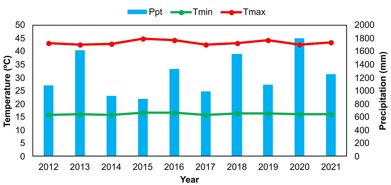
High maximum temperatures, particularly in combination with low rainfall, amplify fire risk by reducing relative humidity and drying vegetation, making it more combustible ([44]). Analysis of precipitation from 2012 to 2021 reveals that 2015 was an unusually arid year, with only 876.66 mm of rainfall, exacerbated by high temperatures associated with a strong El Niño event. These conditions intensified fire risks in southeastern Brazil, stressing the importance of climate monitoring in fire prevention efforts ([7]).
In response to recurring fire risks, national policies, such as the Brazilian Forest Code, mandate responsible fire management and wildfire prevention, which are crucial to protecting forest ecosystems. Local programs, such as PRAVALER and the Municipal Atlantic Forest Plans, focus on restoring native forest cover and enforcing the Atlantic Forest Law at the municipal level ([41]).
These strategies, supported by environmental laws and proactive restoration efforts, are crucial for enhancing forest resilience and mitigating fire impacts, which will be increasingly vital as climate change intensifies.
Conclusion
Despite the area affected by fires, an overall increase in forest cover was observed over the study period. These findings indicate that, despite the damage caused by fires, recovery and reforestation efforts have positively impacted forest ecosystems, highlighting the vital role of conservation and restoration initiatives in enhancing the resilience of forest ecosystems. This reinforces the value of projects aimed at restoring the Atlantic Forest in Espírito Santo, such as the Reflorestar Program. However, it is essential to maintain consistent monitoring and implement measures to prevent and combat wildfires, thereby protecting forest areas and reducing future risks. As climate conditions become increasingly extreme, ecosystems become more vulnerable and fragile, stressing the need for proactive management and protection strategies.
Acknowledgments
DS conceived the idea, drafted, and revised the manuscript; GB processed the data and helped draft the manuscript; NM processed the data and helped draft the manuscript; ES helped process the data; CV helped draft the manuscript; JM helped draft the manuscript; TF helped draft the manuscript.
The authors thank the Federal University of Espírito Santo for its support.
This research did not receive any specific subsidies from funding agencies in the public, commercial, or non-profit sectors.
References
Gscholar
Gscholar
Gscholar
Gscholar
Online | Gscholar
CrossRef | Gscholar
CrossRef | Gscholar
CrossRef | Gscholar
CrossRef | Gscholar
CrossRef | Gscholar
Gscholar
CrossRef | Gscholar
Gscholar
CrossRef | Gscholar
Online | Gscholar
Online | Gscholar
Authors’ Info
Authors’ Affiliation
Gabrielli Machado Bindeli 0000-0002-3159-4046
Nívea Maria Mafra Rodrigues 0000-0002-3750-0813
Elaine Cordeiro dos Santos 0000-0003-4502-6055
Carem Cristina Araujo Valente 0000-0002-1718-1720
Joana Scheidegger Marinato
Thaís Arão Feletti 0000-0001-7637-1586
Department of Forestry and Wood Sciences, Universidade Federal do Espírito Santo, rua Conceição Augusta de Souza 13, Jerônimo Monteiro (Brazil)
Corresponding author
Paper Info
Citation
Sales DCM, Bindeli GM, Rodrigues NMM, dos Santos EC, Valente CCA, Marinato JS, Feletti TA (2025). Fire influence on forest cover in the Caparaó microregion, state of Espírito Santo, Brazil. iForest 18: 267-272. - doi: 10.3832/ifor4608-018
Academic Editor
Davide Ascoli
Paper history
Received: Mar 22, 2024
Accepted: May 04, 2025
First online: Oct 14, 2025
Publication Date: Oct 31, 2025
Publication Time: 5.43 months
Copyright Information
© SISEF - The Italian Society of Silviculture and Forest Ecology 2025
Open Access
This article is distributed under the terms of the Creative Commons Attribution-Non Commercial 4.0 International (https://creativecommons.org/licenses/by-nc/4.0/), which permits unrestricted use, distribution, and reproduction in any medium, provided you give appropriate credit to the original author(s) and the source, provide a link to the Creative Commons license, and indicate if changes were made.

Web Metrics
Breakdown by View Type
Article Usage
Total Article Views: 5070
(from publication date up to now)
Breakdown by View Type
HTML Page Views: 2425
Abstract Page Views: 1375
PDF Downloads: 1096
Citation/Reference Downloads: 0
XML Downloads: 174
Web Metrics
Days since publication: 285
Overall contacts: 5070
Avg. contacts per week: 124.53
Article Citations
Article citations are based on data periodically collected from the Clarivate Web of Science web site
(last update: Mar 2025)
(No citations were found up to date. Please come back later)
Publication Metrics
by Dimensions ©
Articles citing this article
List of the papers citing this article based on CrossRef Cited-by.
Related Contents
iForest Similar Articles
Research Articles
Near zero mortality in juvenile Pinus hartwegii Lindl. after a prescribed burn and comparison with mortality after a wildfire
vol. 12, pp. 397-402 (online: 31 July 2019)
Review Papers
Remote sensing of selective logging in tropical forests: current state and future directions
vol. 13, pp. 286-300 (online: 10 July 2020)
Technical Reports
Detecting tree water deficit by very low altitude remote sensing
vol. 10, pp. 215-219 (online: 11 February 2017)
Review Papers
Remote sensing-supported vegetation parameters for regional climate models: a brief review
vol. 3, pp. 98-101 (online: 15 July 2010)
Review Papers
Accuracy of determining specific parameters of the urban forest using remote sensing
vol. 12, pp. 498-510 (online: 02 December 2019)
Research Articles
Does degradation from selective logging and illegal activities differently impact forest resources? A case study in Ghana
vol. 9, pp. 354-362 (online: 29 January 2016)
Research Articles
Mapping the vegetation and spatial dynamics of Sinharaja tropical rain forest incorporating NASA’s GEDI spaceborne LiDAR data and multispectral satellite images
vol. 18, pp. 45-53 (online: 01 April 2025)
Research Articles
Assessment of land sensitivity to degradation using MEDALUS model - a case study of Grdelica Gorge and Vranjska Valley (southeastern Serbia)
vol. 15, pp. 163-170 (online: 07 May 2022)
Research Articles
Geostatistical techniques for estimating aboveground biomass in eastern Amazonia
vol. 19, pp. 85-93 (online: 13 March 2026)
Review Papers
Monitoring the effects of air pollution on forest condition in Europe: is crown defoliation an adequate indicator?
vol. 3, pp. 86-88 (online: 15 July 2010)
iForest Database Search
Google Scholar Search
Citing Articles
Search By Author
Search By Keywords


