Status and socio-economic significance of wetland in the tropics: a study from Bangladesh
iForest - Biogeosciences and Forestry, Volume 2, Issue 5, Pages 172-177 (2009)
doi: https://doi.org/10.3832/ifor0512-002
Published: Oct 15, 2009 - Copyright © 2009 SISEF
Research Articles
Abstract
This study was carried out in the adjacent communities of the Hakaluki haor, the largest inland freshwater wetland of Bangladesh to explore their socio-economic status and haor-based livelihood dependency. Hakaluki haor is a poverty stricken region with 37% households falling into extreme poor group having monthly income of Tk 2 000.00 only. More than half of the community view Hakaluki haor as the vital source of livelihoods. The surrounding community is dependent on the haor in varying degree (15% totally dependent, 32% moderately and 53% less) with a variety of livelihood activities like fishing and related profession (32%), duck rearing (29%), cattle rearing (28%), fuel wood collection (6%), sand extraction (3%) and reed collection (2%). The average annual household incomes from fishing of naturally available fish, pisciculture and NTFPs collection are Tk 21 701.35, Tk 31 524.83 and Tk 2 704.80, respectively. The haor serves as the source of fuel for cooking to a majority of the community (48%). The respondents identified over-exploitation of fish resources, use of excessive pesticides and gradual increase of human settlement in and around the haor as the most threatened events. With the designation as Ecologically Critical Area (ECA) by the government, immediate attempts should be taken to ensure sustainable utilization of the haor resources. Development of integrated management plan with a provision of the participation of local stakeholders may become the possible way of conserving this wetland.This study was carried out in the adjacent communities of the Hakaluki haor, the largest inland freshwater wetland of Bangladesh to explore their socio-economic status and haor-based livelihood dependency. Hakaluki haor is a poverty stricken region with 37% households falling into extreme poor group having monthly income of Tk 2 000.00 only. More than half of the community view Hakaluki haor as the vital source of livelihoods. The surrounding community is dependent on the haor in varying degree (15% totally dependent, 32% moderately and 53% less) with a variety of livelihood activities like fishing and related profession (32%), duck rearing (29%), cattle rearing (28%), fuel wood collection (6%), sand extraction (3%) and reed collection (2%). The average annual household incomes from fishing of naturally available fish, pisciculture and NTFPs collection are Tk 21 701.35, Tk 31 524.83 and Tk 2 704.80, respectively. The haor serves as the source of fuel for cooking to a majority of the community (48%). The respondents identified over-exploitation of fish resources, use of excessive pesticides and gradual increase of human settlement in and around the haor as the most threatened events. With the designation as Ecologically Critical Area (ECA) by the government, immediate attempts should be taken to ensure sustainable utilization of the haor resources. Development of integrated management plan with a provision of the participation of local stakeholders may become the possible way of conserving this wetland.
Keywords
Introduction
The term “haor” denotes the bowl-shaped large tectonic depression that receives surface runoff water by rivers and canals, and consequently, becomes very extensive water body in the monsoon and dries up mostly in the post-monsoon periods ([2]). In Bangladesh haors are found mainly in the north/eastern region covering the parts of greater Sylhet and Mymensingh. Hakaluki haor is the largest inland freshwater wetland ecosystem in Bangladesh and one of the largest in south Asia ([4], [1]). It is composed of 6 000 beels (small freshwater lakes) and covers up to 18 000 ha of area during rainy season in the periods of mid-May to mid-July ([10]). While the beels have several inlets, such as the rivers - the Juri, the Kantinala, and the Kuiachari - there is only one outlet, the Kushiyara River ([1]). Hakaluki haor is located in the north-eastern part of Bangladesh, between the districts of Sylhet and Moulvibazar. It supports a wide variety of agricultural and horticultural crops and fast growing introduced timber species ([28]). A significant number of medicinal plants are also found in the haor. This haor ecosystem supports at least 73 species of wetland vegetation, which is nearly half of the national total of 158 species of vegetation ([7]). It is a critical habitat and breeding ground for fish and other aquatic species and considered one of the four major “mother fisheries” in Bangladesh ([25]). More than 100 fish species are available in the haor, one third of which are listed as endangered ([1], [7]). The haor is also the home for globally significant waterfowl especially large number of’ migratory duck species that pass the winter season there. There was an estimation of wintering population of ducks in 1960s at between 40 000 to 60 000 ([6]). There are a number of varieties of mammals and reptiles including snakes, frogs, turtles, toads, tortoises, squirrel, and the gangetic dolphin inhabiting in and around the haor.
About 200 000 people live around Hakaluki haor; all of them, more or less, are dependent on its resources for their livelihoods ([7]). As the haor floods annually, settlements are clustered along its slightly raised fringes. Fisheries and agriculture are the two major livelihoods for local people living in and around Hakaluki haor ([5]). The haor once was with plenty of wildlife and aquatic resources and covered with swamp forest, which in the recent time has become a fast-degraded landscape facing increased pressure and threats ([1]). The forest resources (swamp and reed land plants) in the haor area have no proper conservation and management technique, for which those are declining gradually. Such rapid degradation of the wetland ecology is causing devastating consequences on the community people living in, around and downstream of the haor who for generations were dependent for their livelihoods upon vital functions, services and benefits provided by this wetland. On ground of such threats and rapid degradation of the resources and in recognition of the urgent need to protect its unique ecology and biodiversity, the Government of Bangladesh has declared Hakaluki haor as an “Ecologically Critical Area” (ECA) in 1999 under the provision of the Bangladesh Environment Conservation Act ([4]). The fact that Hakaluki haor has been designated as an Ecologically Critical Area (ECA) signifies its importance as a reservoir of disappearing natural resources ([1]).
Bangladesh is an excellent representative of tropical regions rich with huge biological diversity. The wetlands of Bangladesh’s north-eastern region have great ecological, commercial and socio-economic importance. The dynamic interaction of terrestrial and aquatic systems makes these wetlands highly valuable environmentally. The wetlands are recognized as containing very rich components of biodiversity of local, regional and national significance ([31]). The forest resources (swamp and reed land plants) in the haor area have no proper conservation and management technique, for which those are declining gradually. Despite a growing awareness of the need for protecting the environment, degradation has occurred rapidly during the last three decades. As a result, country’s ecology has been damaged, forests depleted, wetlands destroyed, and biodiversity considerably degraded. Due to the excess pressure from overpopulation, the wetlands are also under serious threat with most of it being encroached upon by the local people. In recent years, as a direct consequence of agricultural expansion, many wetlands have been shrunk or disappeared. Such degradation has brought about a loss of biodiversity, reduction in fish habitat and loss of wetland-based flora that are a valuable source of a wide range of non-timber forest products (NTFPs). Despite of this widespread values and use of such freshwater wetland as Hakaluki haor, most of the studies on wetland in the country concentrated mainly on the Sundarban mangrove wetlands (e.g., [8], [21], [9], [18], [22], [23], [12], [14], [15], [13], [19]). A very little study was conducted on Hakaluki haor, particularly economic significance of Hakaluki haor in terms of the dependency of local people on it remains largely unexplored. The present study is an initial attempt to realize the interactions among the people, wetland resources and economic activities and to assess inter-linkages between economic and ecological function of the haor system that is directly linked with local livelihoods. The study will serve as a source of baseline information for future researchers interested on similar wetlands in the country.
Methodology
Study Site
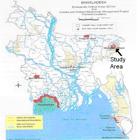
Hakaluki haor lies between latitudes 24° 35’ N to 24° 45’ N and longitudes 92° 00’ E to 92° 08’ E. It is administrated under five upazilas (sub-district: administrative entity) of two districts: Fenchuganj and Golapganj upazilas of Sylhet district and Kulaura, Borolekha and Juri upazilas of Maulvibazar district ([4]). There are 11 unions (a rural administrative unit consisting of a number of villages) under these five upazilas. The study was conducted at Chatla beel and Jolla beel regions of Hakaluki haor situated under Jaifarnagor union of Kulaura upazila and Talimpur union of Borolekha Upazila, respectively (Fig. 1). Total area of Chatla beel is 302.9630 ha and adjacent villages are Sonapur, Velagaon, Bachirpur, Kandigaon, and Chalbon. The physical status of Chatla beel is moderately degraded. On the other hand, total area of Jolla beel is 181.3670 ha and adjacent villages are Sreerampur, Ranginagar, Mulajuri, Dasghori. The physical status of Jolla beel is moderately rich ([6]).
Fig. 1 - Major wetlands of Bangladesh showing the study area.
Methods
The study was conducted in Borolekha and Kulaura upazilas of Moulvibazar district. A multi-stage random sampling technique was applied for the study. From a total of 11 unions under the two upazilas, two unions (Jaifarnagar and Talimpur) were selected randomly. Two villages (Sonapur and Velagaon) from Jaifarnagar union, and two villages (Sreerampur and Mulajuri) from Talimpur union were selected using the same procedure. From these four villages 84 households with a sampling intensity of 12%, were selected randomly for the survey. A semi-structured questionnaire was used for the interview which includes on various socio-economic parameters such as literacy, occupation, farm size, land ownership, knowledge sharing, organizational participation, involvement in farm activities, participation in decision making, access and rights on haor resources, livelihood patterns. Before preparing the final questionnaire, a preliminary one was developed in conformity with the objectives of the study. This draft schedule was pre-tested with a few selected farmers. Some parts of the draft questionnaire were improved, rearranged, and modified in the light of the practical experience gained from the pre-test. It was then finalized and questions were listed in logical sequence, so that the respondents could answer easily. The selected respondents were personally interviewed for collecting reliable data and other information. The respondents were free to express their views on each of the topics. New avenues of questioning were pursued as the interview developed.
For the calculation of average annual household incomes from haor-based livelihoods (including NTFP’s and medicinal plants), following formula was used: Net Income = (revenue from sales of labour and goods, i.e., haor resources + the value of non purchased goods consumed, i.e., haor resources) - (material cash costs + opportunity costs of labour) ([3]). The interview schedule was designed to collect information in local units. However, these were converted into national/international standard units later. To analysis the data obtained from the field level, we used the commercial software MS Excel.
Results
Habitat category and land use pattern in Hakaluki haor
Five categories of habitat were found to exist in the region of Hakaluki haor: beels, rivers or canals, fallow lands, lands for boro crops and lands for rabi crops. Beels were reported to be used for fishing, hunting birds, collection of aquatic plants for food, fodder, and fuel while the rivers or canals for fishing, boating, and transportation. Fallow lands were used for grazing, infrequent vegetation culture, collection of grass and fuel wood. Lands for boro crops, seen at the edges of the haor and within beels becoming dry in the winter, were reported to be used for rice cultivation. On the other hand, lands for rabi crops, found as elevated along the edges of the haor, were used for the cultivation of oil seeds and pulses of various species.
Basic socio-economic and demographic features of the respondents
The total number of the population of studied households was 517 with an average family size of six. Fifty one percent of them were male. All the respondents were male with an average age of 43 years. The primary occupation of the respondent households was dominated by agriculture (38%), followed by fishing (22%), day labour (15%), boatmanship (10%), small business (9%) and remittance from abroad (6%). Based on the average annual income information of the households, we categorized them into three different classes: extremely poor (annual income 24 000); medium (annual income of Tk 24 000-90 000) and rich (annual income of >Tk 90 000). It was found that 37% of the households occupied in the extremely poor group, while 32% in medium and 31% in rich category.
Haor-based livelihoods and income generation
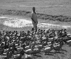
It was revealed that the local people had traditionally been using the haor for various livelihood purposes for centuries (Fig. 2, Fig. 3, Fig. 4). During the study when specific question was asked regarding household dependency on the haor, 15% of them reported the total dependence on Hakaluki haor for livelihoods, while the others were moderately (32%) or less dependent (53%). Among them the people in extreme poor category were found to be entirely dependent on the haor. On an average, the respondents were reported to be involved in a variety of haor-based livelihoods: fishing and related activities (32%), duck rearing (29%), cattle rearing (28%), fuel wood collection (6%), sand extraction (3%), and reed collection (2%). We evaluated the incomes of the households from haor-based livelihoods in three different aspects: aquatic resources mainly fishing related activities that involve naturally available fish in haor, pisciculture involving in fish rearing in beels and/or parts of haor, and non-timber forest products (NTFPs) that include both the aquatic and non-aquatic resources (Tab. 1). The annual average incomes from those three categories of livelihoods were found Tk 21 701.35, Tk 31 524.83 and Tk 2 704.80, respectively. Among the NTFPs, average annual income from medicinal plants was the highest (Tk 3 551.28). All the respondents were reported to use plant parts and cow-dung as fuel for cooking purposes: a majority (48%) reported the haor and its surroundings as the source; others collected it from homesteads (25%), homestead and market (18%) and market only (9%). They mainly collected parts from hijol (Barringtonia acutangula L.), koroch (Pongamia pinnata (L.) Merr.), barun (Crataeva nurvala Buch-Ham.) and gagra (Xanthium indicum Koenig.) as fuel for cooking. The fruits of two aquatic plant bhat (Calamus tenuis Roxb.) and shingra (Cynometra ramiflora L.) were reported to be collected by the children. List of NTFP’s and medicinal plants available in Hakaluki haor is shown in Tab. 2.
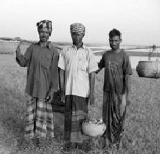
Fig. 2 - Fishermen in Hakaluki haor area.
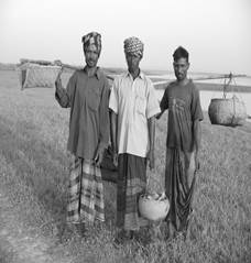
Fig. 3 - Fuel wood collection in Hakaluki haor area.
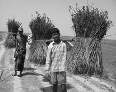
Fig. 4 - Duck rearing in Hakaluki haor area.
Tab. 1 - Average annual household incomes from haor-based livelihoods.
| Resources | Livelihood activities |
No. of respondents |
Frequency (%) | Average annual income (±Standard deviation) |
Total annual income |
Overall average annual income |
|---|---|---|---|---|---|---|
| Capturing naturally available fish |
Full time fishing | 25 | 29.76 | 36 911.76 (± 4178.4) |
922 794 | 21 701.35 |
| Part time fishing | 30 | 35.71 | 25 066.67 (± 3338.8) |
752 000.1 | ||
| Fishing for self consumption | 13 | 15.48 | 2 807.73 (± 909.3) |
36 500.49 | ||
| Fish drying | 8 | 9.52 | 666.67 (± 249.8) |
5 333.36 | ||
| Weaving fishing net | 5 | 5.95 | - | - | ||
| Others | 3 | 3.57 | 35 428.57 (± 4398.2) |
106 285.7 | ||
| Total | 84 | 100 | - | 1 822 914 | ||
| Pisciculture in beels and parts of haor | Supply of fries | 2 | 2.38 | 2 250 (± 537) |
4 500 | 31 524.83 |
| Supply of fish feeds | 1 | 1.19 | 5 000 | 5 000 | ||
| Fish trading | 27 | 32.14 | 26 868.26 (± 3222.1) |
725 443.05 | ||
| All the three categories above | 54 | 64.29 | 35 428.57 (± 4710.2) |
1 913 142.78 | ||
| Total | 84 | 100 | - | 2 648 085.8 | ||
| NTFPs | Food for human | 14 | 16.67 | 3 480 (± 1180) |
48 720 | 2 704.80 |
| Feed for cattle | 35 | 41.67 | 3 430.78 (± 1110.7) |
120 077.30 | ||
| Roofing materials | 2 | 2.38 | 1 085.71 (± 339.5) |
2 171.42 | ||
| Fencing materials | 6 | 7.14 | 888 (± 310) |
5 328 | ||
| Fuel | 17 | 20.24 | 2 620.89 (± 889.5) |
44 555.13 | ||
| Medicinal plants | 1 | 1.19 | 3 551.28 (± 1000.5) |
3 551.28 | ||
| Snail & shell for poultry farms | 2 | 2.38 | 1 400 (± 350) |
2 800 | ||
| Nothing | 7 | 8.33 | - | - | ||
| Total | 84 | 100 | - | 227 203.13 |
Tab. 2 - List of NTFP’s and medicinal plants available in Hakaluki haor.
| Haor products | Local name | Scientific name |
|---|---|---|
| NTFP’s | Alughas | Glinus lotoides |
| Bansupari | Caryola urens | |
| Bishkatali | Polygonum barbatum | |
| Bot | Ficus benghalensis | |
| Brahmishak | Herpestis manniera | |
| Bulkokra | Chaetocarpus casianocarpus | |
| Chapali ghash | Chenopodium ambrosoides | |
| Fulkuri | Ageratum conyzoidcs | |
| Gab | Diospyros perigrina | |
| Haicha | A Iternanthera sessilis | |
| Hatisur | Heliotropium indicum | |
| Helancha | Enhydra fluctuam | |
| Hijol | Barringtonia aculangula | |
| Jalibet | Calamus tennis | |
| Jalibet | Calamus tennis | |
| Jarul | Lagerstroemia speciosa | |
| Kalojam | Syzygium cumini | |
| Karanch | Pongamia pinnata | |
| Khagra | Phragmites karka | |
| Khudijam | Syzygium fruticosa | |
| Kukra | Polygonum glabrum | |
| Mander, Piltamander | Erythrina variegate | |
| Minjiri | Cassia siamea | |
| Monchata | Randia dwnclorum | |
| Narical | Cocos nucifera | |
| Panidumur | Trewia nudiflora | |
| Panihijal | Salix teirasperma | |
| Rendi, Rain tree | Samanea saman | |
| Shapla | Nymphaea nouchali | |
| Singra | Trapa maximowiczii | |
| Sitalpati | Clynogyne dicholoma | |
| Tilamander | Erythrina ovatifolia | |
| Medicinal plants | Am | Mangifera indica |
| Assamlata | Eupaiorium odoratum | |
| Dhol kalmi | Ipomoeae ftstulosa | |
| Durba | Cynodon dactylon | |
| Dutura | Datura metel | |
| Gab | Diospyros perigrina | |
| Hijol | Barringtonia acutangula | |
| Jambura | Citrus grandis | |
| Jarul | Lagerstroemia speciosa | |
| Kochuripana | Vichhornia pseudoraphis | |
| Monkochu | Alocacia indica | |
| Nishinda | Vitex negundo | |
| Swarnalata | Cuscuta auslralis | |
| Thankuni | Centella asiatica | |
| Tulshi | Ocimum amcricanum |
Respondents’ perception about the importance of haor conservation
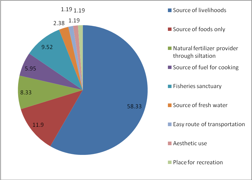
When the respondents were invited to express their perceptions about the importance of haor conservation, all of them gave their opinion. For the majority of them (59.33%) Hakaluki haor was the vital source of livelihoods, while to others it appeared as the source of food only (11.90%), fisheries sanctuary (9.52%), natural fertilizer provider through siltation (8.33%) and so on (Fig. 5). Opinion on the threatened phenomena for Hakaluki haor was also sought from the respondents, in response to which they identified over-exploitation of fish resources (21.5%) and gradual increase of human settlement in and around the haor (18.6%) as the most threatened events. Some other incidences were reported by the respondents as detrimental for the existence of Hakaluki haor (Tab. 3).
Fig. 5 - People’s perception about the importance of conserving Hakaluki haor.
Tab. 3 - Threatened phenomena of and their impacts on Hakaluki haor.
| Destructive activities | Level of invasion (%) |
|---|---|
| Over-exploitation of fish from the haor | 21.5 |
| Use of pesticides in and around the haor | 8.86 |
| Dumping of chemical waste from the nearby industries | 4.89 |
| Use of current nets/cloth nets for catching fish/ fingerlings | 9.98 |
| Loss of habitat/food/shelter for animals | 5.1 |
| Catching birds for bush meat | 1.5 |
| Gradual increase in human settlement in adjacent areas | 18.6 |
| Over-exploitation of tree species | 3.6 |
| Conversion of wetland into agricultural land | 13.98 |
| Pollution of water by throwing garbage and sweepings | 5.6 |
| Unsustainable collection of fuel wood | 4.56 |
| Use of firearms for hunting | 1.6 |
Discussion
Wetlands provide a wide range of economic, social and ecological benefits ([11], [17], [29]). Wetlands are one of the most productive and resourceful areas, which provide food, non-food aquatic resources and retain the ecological balance for the local residents as well as for the nation ([11], [17]). From the perspective of a developing country, wetlands are an important source of commercial fishing, agriculture, seasonal livestock grazing, wood collection, and ecotourism. In Bangladesh, where inland water bodies constitute nearly 50% of total land area ([27]), wetlands are critical to economic development and environmental improvement. The major role of wetland are nutrient retention/removal, support for food chains, fisheries production, habitat for wildlife, recreation, natural heritage values, biomass production, water transport, biodiversity presentation and micro-climate stabilization ([11], [17], [29]). The wetland environment unites the inhabitants into a society, which has a definite shape, culture and livelihood pattern. Due to the availability of wide variety of harvestable products, the people in and around the wetlands are traditionally self-reliant and have subsistence-oriented economy and livelihoods. Bangladesh has traditionally been rich in fish stocks. The inland fisheries system is estimated to contribute almost 73% of total production and supplies 80% of the country’s animal protein requirements ([29]). [26] found that an annual economic output value estimated for Hail haor, another large wetland of Moulvibazar district is US$ 8 Million, the net present value of which over 15 years is US$ 83 million. CWBMP Project Document ([30]) found that average income of the people living around the Hakaluki haor from capture fisheries is over Tk 16 000 per household, and that nearly half of the households are engaged in this profession. Moreover, pisciculture is also a growing industry in the area, providing an average income of Tk 31 524.83 for participating households. IUCN ([16]) revealed, 23.54 % people’s monthly income in Hakaluki haor area is more than Tk 7 000.00. The present study explored an interesting scenario of the role of wetlands on local livelihoods and its impacts on wetland ecology in Bangladesh. Ahmed et al. ([1]) reported that fisheries and agriculture are the two major livelihoods for local people living in and around the wetlands while other livelihood supports are provided by cattle grazing, NTFPs collection, duck rearing, and sand mining from there. All these livelihoods are available in Hakaluki haor region also. Despite all these support to human livelihoods, many parts of the world have experienced loss or degradation of wetlands on a huge scale because of agricultural use, urbanization, excessive exploitation by local population ([24]). Hakaluki haor is also facing similar kind of threats (Tab. 3) mainly due to over exploitation, which ultimately deteriorates the haor ecology. Due to continuous degradation of the haor ecology, the respondents of the haor give emphasis about the importance of conserving the Hakaloki haor (Fig. 5). So there is a clear inter-linkage between economic and ecological function of Hakaluki haor. Development of integrated management plan with a provision of the participation of local stakeholders may become the possible way of conserving this wetland ecology.
Conclusion
This study underscores the reality that Hakaluki haor also constitutes an important source of natural capital, which yields high economic and livelihood values to surrounding populations and the country as a whole. In Bangladesh the population is increasing day by day at higher rates but the natural resources are not increasing at the same time ([20]). Poverty greatly affects the environment and poverty is at a critical stage on the study area, which will influence the local people for continuous destruction of haor resources. Prevention of further decline of the wetland will require adoption of multiple-use land management based on principles of sustainable development. An integrated management plan is needed that includes utilization of wood and non-wood products, agriculture, fisheries and conservation of biodiversity. A core area and a buffer zone would need to be demarcated when allocating land use in wetland areas. Moreover, public awareness has to be developed for wetland resource management. It will also be necessary in some areas to relocate the encroachers and place restrictions on the entry of new settlers. Above all, sustainable management will only be possible if the government undertakes participatory management of wetland involving the stakeholders in and around the wetland areas.
Acknowledgements
Our sincere appreciation to all the respondents of the study area for sharing their information as well as for the heartiest cooperation during our field surveys. The authors deem their heartfelt gratitude to Mr. Md. Sharif Ahmed Mukul, Department of Forestry and Environmental Sciences, Shahjalal University of Sciences and Technology, Sylhet, Bangladesh for providing necessary literatures during manuscript preparation.
References
Gscholar
Gscholar
Gscholar
Gscholar
Gscholar
Gscholar
Gscholar
Gscholar
Gscholar
Gscholar
Gscholar
Gscholar
Gscholar
Gscholar
Gscholar
Gscholar
Gscholar
Authors’ Info
Authors’ Affiliation
S Sohel MSI Akhter
Department of Forestry and Environmental Science, Shahjalal University of Science and Technology, Sylhet-3114 (Bangladesh)
M Koike
Forest Policy Laboratory, Department of Forest Science, Faculty of Agriculture, Shinshu University, 8304 Minamiminow-Mura, Nagano-Ken 399-4598 (Japan)
Corresponding author
Paper Info
Citation
Rana MP, Chowdhury MSH, Sohel MSI Akhter S, Koike M (2009). Status and socio-economic significance of wetland in the tropics: a study from Bangladesh. iForest 2: 172-177. - doi: 10.3832/ifor0512-002
Academic Editor
Marco Borghetti
Paper history
Received: May 07, 2009
Accepted: Jul 21, 2009
First online: Oct 15, 2009
Publication Date: Oct 15, 2009
Publication Time: 2.87 months
Copyright Information
© SISEF - The Italian Society of Silviculture and Forest Ecology 2009
Open Access
This article is distributed under the terms of the Creative Commons Attribution-Non Commercial 4.0 International (https://creativecommons.org/licenses/by-nc/4.0/), which permits unrestricted use, distribution, and reproduction in any medium, provided you give appropriate credit to the original author(s) and the source, provide a link to the Creative Commons license, and indicate if changes were made.

Web Metrics
Breakdown by View Type
Article Usage
Total Article Views: 61637
(from publication date up to now)
Breakdown by View Type
HTML Page Views: 51251
Abstract Page Views: 2861
PDF Downloads: 6545
Citation/Reference Downloads: 32
XML Downloads: 948
Web Metrics
Days since publication: 5756
Overall contacts: 61637
Avg. contacts per week: 74.96
Article Citations
Article citations are based on data periodically collected from the Clarivate Web of Science web site
(last update: Mar 2025)
Total number of cites (since 2009): 9
Average cites per year: 0.53
Publication Metrics
by Dimensions ©
Articles citing this article
List of the papers citing this article based on CrossRef Cited-by.
Related Contents
iForest Similar Articles
Research Articles
Implications of ecotourism development in protected areas: a study from Rema-Kalenga Wildlife Sanctuary, Bangladesh
vol. 3, pp. 23-29 (online: 22 January 2010)
Research Articles
The role of palm husbandry in the rural economy of the south-eastern region of Bangladesh
vol. 3, pp. 39-43 (online: 02 March 2010)
Review Papers
A review of the environmental Kuznets curve hypothesis for deforestation policy in Bangladesh
vol. 4, pp. 16-24 (online: 27 January 2011)
Technical Reports
Deforestation, land conversion and illegal logging in Bangladesh: the case of the Sal (Shorea robusta) forests
vol. 5, pp. 171-178 (online: 25 June 2012)
Research Articles
Domestic use of biomass fuel in the rural Meghna floodplain areas of Bangladesh
vol. 3, pp. 144-149 (online: 27 September 2010)
Research Articles
Predicting impacts of climate change on forest tree species of Bangladesh: evidence from threatened Dysoxylum binectariferum (Roxb.) Hook.f. ex Bedd. (Meliaceae)
vol. 10, pp. 154-160 (online: 25 May 2016)
Research Articles
Allometric models for estimating biomass, carbon and nutrient stock in the Sal zone of Bangladesh
vol. 12, pp. 69-75 (online: 24 January 2019)
Research Articles
Allometric relationships for predicting the stem volume in a Dalbergia sissoo Roxb. plantation in Bangladesh
vol. 3, pp. 153-158 (online: 15 November 2010)
Short Communications
QA/QC activities and ecological monitoring in the Acid Deposition Monitoring Network in East Asia (EANET)
vol. 2, pp. 26-29 (online: 21 January 2009)
Research Articles
Nutrients (N, P and K) dynamics associated with the leaf litter of two agroforestry tree species of Bangladesh
vol. 2, pp. 183-186 (online: 15 October 2009)
iForest Database Search
Search By Author
Search By Keyword
Google Scholar Search
Citing Articles
Search By Author
Search By Keywords
PubMed Search
Search By Author
Search By Keyword


