Web GIS-based simulation of water fluxes in the Miyun catchment area
Micha Gebel (1) , Ralph Meissner (2), Stefan Halbfass (1), Jens Hagenau (2), Shuhuai Duan (3)
iForest - Biogeosciences and Forestry, Volume 7, Issue 6, Pages 363-371 (2014)
doi: https://doi.org/10.3832/ifor1169-007
Published: May 19, 2014 - Copyright © 2014 SISEF
Research Articles
Collection/Special Issue: RegioResources21
Spatial information and participation of socio-ecological systems: experiences, tools and lessons learned for land-use planning
Guest Editors: Daniele La Rosa, Carsten Lorz, Hannes Jochen König, Christine Fürst
Abstract
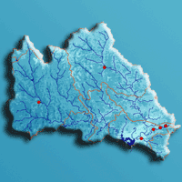
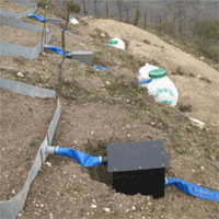
Change of land use and agricultural management, combined with severe droughts during the last two decades, are the main reasons for a strong decrease of water quality and quantity in the Miyun reservoir (China). Due to semi-arid monsoon climate, episodic water fluxes have to be considered adequately in an integrated water resources management in the total catchment area. To get insight into runoff generation processes, sediment and nutrient source areas and transfer dynamics, a monitoring approach was established in the Miyun catchment area spanning from plot measurements with weighable gravitation lysimeters and in situ measurements to a subcatchment scale of approx. 10 km2. One of these subcatchments (Sheyuchuan) was selected to adapt the methodologies to the regional runoff pattern using the web GIS-based modeling tool STOFFBILANZ. Calibration of the daily runoff modeling is based on the lysimeter observations from Shixia station and runoff observations in Sheyuchuan subcatchment for the reference year 2011. Despite the fact that the climatic water balance in the region is negative, the precipitation event on 24 July 2011 with a rainfall of 107 mm caused a significant leachate at the lysimeter. The daily modeling for the lysimeter core by the FAO-ETc-adj approach showed a similar deep percolation and a similar distribution of evapotranspiration for the year considered. In the next step, the calibrated model was applied to the subcatchment Sheyuchuan to compare the results of direct runoff and groundwater runoff (deep percolation) with the runoff observations at the weir. Deep percolation was extremely small (1.7 mm yr-1), and direct runoff was 26.9 mm yr-1 in 2011. In comparison to the monitoring results at the weir, a disagreement in the quantity of runoff was found between the observation on the one hand and the simulation on the other hand, which can be explained by water storage in reservoirs for irrigation purposes. Additionally, the water fluxes in the total catchment area were simulated at meso-scale, obtaining a good correlation with observed values.
Keywords
Bottom-up, Direct Runoff, Lysimeter, Meso Scale, Miyun, Model, Percolation
Authors’ Info
Authors’ address
Stefan Halbfass
Gesellschaft für Angewandte Landschaftsforschung (GALF) bR, Am Ende 14, D-01277 Dresden (Germany)
Jens Hagenau
Helmholtz-Centre for Environmental Research - UFZ, Department Soil Physics, Lysimeter station, Dorfstr. 55, D-39615 Falkenberg (Germany)
Beijing Soil and Water Conservation Center, No.5 Yunuantan South Road, Haidian District, 100038 Beijing (China)
Corresponding author
Paper Info
Citation
Gebel M, Meissner R, Halbfass S, Hagenau J, Duan S (2014). Web GIS-based simulation of water fluxes in the Miyun catchment area. iForest 7: 363-371. - doi: 10.3832/ifor1169-007
Academic Editor
Marco Borghetti
Paper history
Received: Oct 31, 2013
Accepted: Nov 20, 2013
First online: May 19, 2014
Publication Date: Dec 01, 2014
Publication Time: 6.00 months
Copyright Information
© SISEF - The Italian Society of Silviculture and Forest Ecology 2014
Open Access
This article is distributed under the terms of the Creative Commons Attribution-Non Commercial 4.0 International (https://creativecommons.org/licenses/by-nc/4.0/), which permits unrestricted use, distribution, and reproduction in any medium, provided you give appropriate credit to the original author(s) and the source, provide a link to the Creative Commons license, and indicate if changes were made.

Web Metrics
Breakdown by View Type
Article Usage
Total Article Views: 58581
(from publication date up to now)
Breakdown by View Type
HTML Page Views: 48458
Abstract Page Views: 3898
PDF Downloads: 4689
Citation/Reference Downloads: 19
XML Downloads: 1517
Web Metrics
Days since publication: 4451
Overall contacts: 58581
Avg. contacts per week: 92.13
Citation Metrics
Article Citations
Article citations are based on data periodically collected from the Clarivate Web of Science web site
(last update: Mar 2025)
Total number of cites (since 2014): 5
Average cites per year: 0.42
Publication Metrics
by Dimensions ©
Articles citing this article
List of the papers citing this article based on CrossRef Cited-by.
References
Crop Evapotranspiration - guidelines for computing crop water requirements. FAO Irrigation and Drainage Paper No. 56, FAO, Rome, Italy, pp. 300.
Gscholar
Curve number hydrology: state of the practice. American Society of Civil Engineers, Reston, VA, USA, pp. 106.
Gscholar
The USLE-M and modeling erosion within catchments. In: Proceedings of “10th International Soil Conservation Organization Meeting: Sustaining the Global Farm” (Stott DE, Mohtar RH, Steinhardt GC eds). Purdue University (Indiana, USA) 24-29 May 1999. USDA-ARS National Soil Erosion Research Laboratory, West Lafayette, IN, USA, pp. 924-928.
Gscholar
Use of lysimeters for sustainable management of the Chinese Miyun drinking water reservoir. 15.Gumpensteiner Lysimetertagung, 16-17.04.2013: Lysimeterforschung als Bestandteil der Entscheidungsfindung, HBFLA Raumberg-Gumpenstein, pp. 35-40. [in German with English abstract]
Online | Gscholar
Development and implementation of a scientifically based management system for non-point source pollution control in the Miyun Basin near Beijing. In: “Integrated Water Resources Management: from Research to Implementation” (Ibisch R, Kirschke S, Stärz C, Borchardt D eds). BMBF, Leipzig, Germany, pp. 27-29.
Online | Gscholar
Catchment-based water management in the Miyun Reservoir - a contribution to safeguarding the drinking water supply of Beijing. KW Korrespondenz Wasserwirtschaft 4 (12/11): 674-679.
Gscholar
Quenching Beijing’s thirst: the need for integrated management for the endangered Miyun reservoir. China Environment Series 7: 33-45.
Gscholar
Factors affecting farmers’ decision on fertilizer use: a case study for the Chaobai watershed in Northern China. The Journal of Sustainable Development 3 (1): 80-102.
Gscholar
Related Content
Sensoy H, Kara O
Vol. 7, pp. 110-114 (online: Apr 2014)
Pshegusov R, Khanov Z, Chadaeva V
Vol. 17, pp. 120-131 (online: Apr 2024)

Stephan J, Bercachy C, Bechara J, Charbel E, López-Tirado J
Vol. 13, pp. 230-237 (online: Jun 2020)
Koutsias N, Allgöwer B, Kalabokidis K, Mallinis G, Balatsos P, Goldammer JG
Vol. 9, pp. 195-204 (online: Apr 2016)
Jochheim H, Puhlmann M, Beese F, Berthold D, Einert P, Kallweit R, Konopatzky A, Meesenburg H, Meiwes K-J, Raspe S, Schulte-Bisping H, Schulz C
Vol. 2, pp. 7-10 (online: Jan 2009)
Eickenscheidt N, Augustin Nicole H, Wellbrock N
Vol. 12, pp. 338-348 (online: Aug 2019)
Leopardi M, Scorzini AR
Vol. 8, pp. 302-307 (online: Jun 2015)

D’Ippolito A, Ferrari E, Iovino F, Nicolaci A, Veltri A
Vol. 6, pp. 175-182 (online: Aug 2013)
Eastaugh CS, Hasenauer H
Vol. 4, pp. 212-217 (online: Nov 2011)
Staelens J, Neirynck J, Genouw G, Roskams P
Vol. 2, pp. 30-33 (online: Jan 2009)


