
Post-fire assessment of soil physicochemical properties in Tamgout Forest, Northern Algeria
iForest - Biogeosciences and Forestry, Volume 19, Issue 6, Pages 403-410 (2026)
doi: https://doi.org/10.3832/ifor4956-019
Published: Nov 09, 2026 - Copyright © 2026 SISEF
Research Articles
Abstract
Understanding how fires affect forest ecosystem components is crucial for predicting vegetation recovery and guiding forest management. Yet information on wildfire consequences for soil properties remains limited in Algeria. This study investigated the impact of wildfire on the physicochemical and structural properties of forest soil in the Tamgout area, northern Algeria. Soil samples were collected along a post-fire chronosequence (2, 10, and 18 years) and compared to an unburned soil (control). ANOVA analysis revealed significant fire-induced changes in key soil properties, including moisture content (M), texture, electrical conductivity (EC), total Nitrogen (TN), organic carbon (OC), organic matter (OM), and mineral content (K+, Ca2+, Na+, Fe, and Mn). In contrast, no significant differences were observed in pH, CaCO3, and Mg2+ contents. The Fourier transform infrared spectroscopy (FTIR) showed marked spectral shifts in mineral bands, particularly in the mid-infrared region, distinguishing burned from unburned soils. X-ray diffraction (XRD) analysis further demonstrated progressive crystallographic alterations, including peak broadening, reduced intensity, and microstructural degradation in fire-affected soils, indicating mineral disorder and reduced crystallinity. These findings highlight the long-term effects of fire on soil composition, structure, and other parameters that play a critical role in forest resilience, ecosystem recovery, and biodiversity conservation in Mediterranean woodland environments.
Keywords
Introduction
Forest fires (FF) play a crucial role in altering soil properties and landscapes, influencing forest ecosystem dynamics and regeneration potential ([46]). Fire-induced soil property alteration depends on both the temperatures reached at different soil depths and the tolerance of soil nutrients to heat ([1]). FF-related disturbances in the Mediterranean region are receiving more attention due to frequent prolonged dry seasons and high temperatures, which trigger wildfires at short intervals, devastating large areas. In addition to FF, soils are exposed to clearing, overgrazing, trampling by herds, and human activities ([43]). Consequently, these factors significantly degrade soil quality and accelerate erosion. Other abiotic factors such as topography and climate change also significantly affect soil properties ([5]). However, FF impacts vary across ecosystems in space and time, considering pre-fire vegetation conditions and post-fire vegetation recovery ([47]). Moreover, Santorufo et al. ([42]) claimed that soil properties such as pH, water content, organic matter, organic carbon, and total nitrogen concentrations are significantly influenced by FF. These authors reported that total and available concentrations of Ca2+, K+, Mg2+, Na+, P, and trace elements such as Fe and Mn are also affected after a fire. These findings showed that temporal changes in soil element concentrations occurred at different rates, suggesting a comprehensive alteration of soil conditions.
In this context, Doblas-Miranda et al. ([16]), Hrelja et al. ([25]), and Kastridis et al. ([28]) highlighted the immediate and short-term impacts of FF on soil, noting that FF effects on soil properties return as a function of time since FF. These insights support adapting management of burned areas, particularly under climate change scenarios that make recurrence more frequent ([21]). Although extensive research worldwide has investigated FF impacts on soil characteristics, findings cannot be readily generalized because they usually focus on specific contexts based on emphasis, environment, and methodology ([35]).
In the Mediterranean region, numerous studies have examined the positive and negative impacts of FF on soil properties ([20], [40], [18]). Algeria is one of the main hotbeds of FF in the southern Mediterranean region because of high FF activity along its northern coastal fringe ([14], [23]). However, only a few studies in Algeria have reported mineralogical changes in forest soils after fires ([6], [3], [35]). Sustainable management of Algerian forest services requires a thorough assessment of the physicochemical properties of burned soils and ecosystems’ vulnerability to soil disturbances. Any rehabilitation or regeneration program for burned forest ecosystems must account for FF impacts on soils ([9]).
This study investigated the effects of fires on the physicochemical characteristics and nutrient dynamics of soils in the Tamgout forest area, considered fairly representative of forest formations in the sub-humid climate zone challenged by increasingly frequent forest fires. The main objective was to compare the short- and long-term recovery dynamics of burnt and unburnt (control) sites, focusing on both macro- and micronutrients, soil texture, and mineralogy.
Materials and methods
Study area
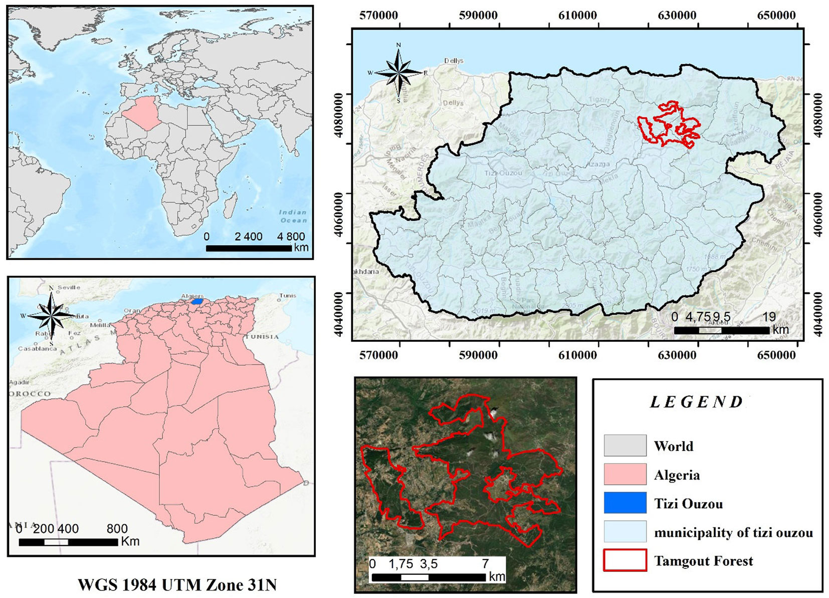
The Tamgout forest is located in the Tizi Ouzou department, part of the Kabylia coastal chain. It is located on a ridge 5 km from the sea (Azeffoun) to the north, between 04° 19′ 15″ and 04° 27′ 40″ East longitude and 36° 45′ 30″ and 36° 50′ 40″ North latitude (Fig. 1). With a surface area of 3.800 ha, it overlaps four municipalities, namely Akerrou (East) and Aghrib (West). Tamgout forest is divided into 18 forest provinces managed by the Forest Management Directorate of Tizi Ouzou. The region’s climate is typically Mediterranean, with mild, wet winters and hot, dry summers, with average annual rainfall of 1.053 mm and average annual temperatures of 15.59 °C. The vegetation is mainly composed of cork oak (Quercus suber), with 33% pure stands and mixed patches of cork oak, zeen oak (Q. canariensis), and afares oak (Q. afares). We chose the site because it contains two areas: the first was burnt in different years, while the second area has not burned. This allows us to observe the effect of FF on the physicochemical properties of burnt and unburnt forest soil. Fig. 1 shows the geographical location of the study site.
Fig. 1 - Geographic location of the study site in the Tamgout Forest, Algeria.
Data collection
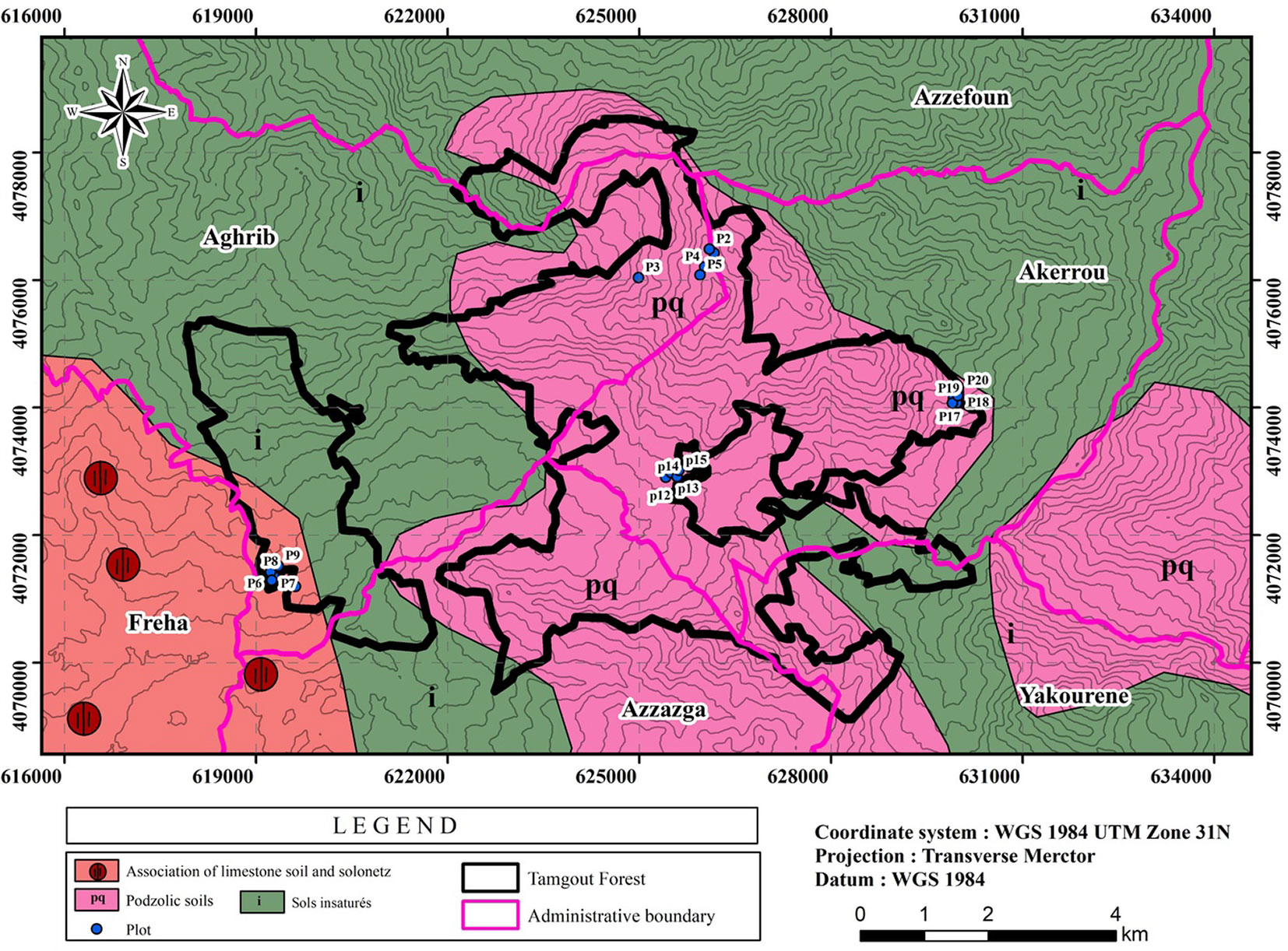
The sampling was performed in summer. Fig. 2 shows the sample locations on a map of soil types in the Tamgout forest.
Fig. 2 - Localization of sampling sites on Tamgout forest soil type map.
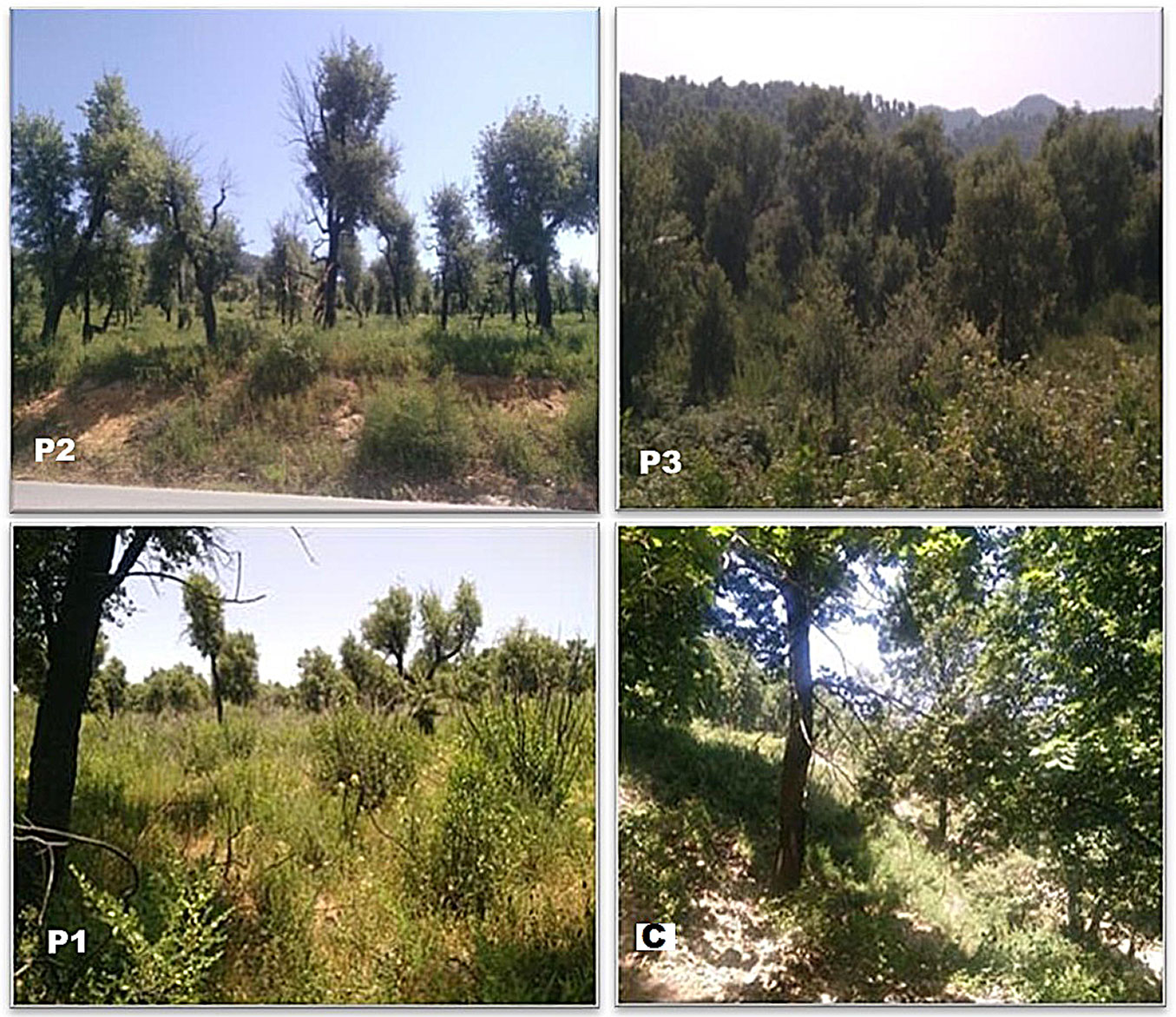
The undergrowth is dense, and the tree formation is dominated by cork oak in the three fire strata, and is clear and dominated by zeen oak in the control fire stratum (C). Tab. 1 provides additional information on the four strata.
Tab. 1 - Characteristics of the sampled strata of the Tamgout forest.
| Samples | P1 | P2 | P3 | C |
|---|---|---|---|---|
| Canton name | Ihmamouchene | Ait Lader | Tala Ghanim | Tamgout |
| Sampling date | June 23, 2019 | June 20.2019 | June 23, 2019 | June 13, 2019 |
| Last fire (yrs) | 2 | 10 | 18 | Control |
| Climate | Temperate subhumid | Temperate subhumid | Temperate subhumid | Temperate subhumid |
| Elevation (m) | 680 | 401 | 530 | 1100 |
| Slope (%) | 12.5-25 | 12.5-25 | 12.5-25 | 3-12.5 |
| Aspect | South-West | North-East | North-East | North-East |
| Vegetation cover (%) | Dense | clear | Very dense | Very dense |
| Dominant tree species | Cork oak | Cork oak | Cork oak | Cork oak and Oak zeen |
| Understory dominant species | Rubus ulmifolius, Erica arborea, Cistus salviifolius, Calicotome spinosa, Genista tricuspidata | Rubus ulmifolius, Erica arborea, Cistus salviifolius, Calicotome spinosa, Genista tricuspidata | Rubus ulmifolius, Erica arborea, Cistus salviifolius, Calicotome spinosa, Genista tricuspidata | Cytisus villosus, Erica arborea |
We determined sampling locations within the plot as randomly as possible by walking through the entire plot in a zigzag pattern. We took samples using an auger at depths of 0-10 cm, corresponding to the organo-mineral surface horizon A, because this layer is the first and most intensely impacted by fire ([32], [14]). Twenty study plots of 400 m2 (5 plots/fire strata) were selected from four fire strata. Each plot was randomly sampled at 6 points after total litter removal ([50]). Fire strata were named according to fire recurrence period: 2 years (P1), 10 years (P2), 18 years after the fire (P3), and control (C).
The samples were mixed to obtain a composite sample of 1 kg per plot. Each composite sample was placed in a hermetically sealed bag and identified by origin, sample, plot, and fire strata.
In the laboratory, part of each sample was sieved after air-drying. The remaining part was kept in a refrigerator, awaiting further analyses carried out a few days after sampling. Fig. 3 shows photos of the different fire layers taken during sampling.
Fig. 3 - Fire strata identified in Tamgout forest: P1, P2, P3, and C.
Physical and chemical analysis
Soil analysis enables the monitoring of soil fertility. Prior to analysis, soil samples were spread out and air-dried for 72 hours, then crushed and passed through a 2 mm sieve. After homogenization, the fine soil samples were kept in airtight boxes. Physicochemical analyses, pH, and soil EC were measured separately in deionized water at soil/water ratios of 1:5 and 1:2.5, according to McLean ([33]). Soil MC was determined by taking 5 g of wet soil samples.
The samples were weighed before and after oven drying at 105 °C for 24 h. Total limestone was determined by the calcimeter Bernard method ([4]). This method measures the CO2 volume released by the soil samples in the presence of hydrochloric acid (HCl). TN was measured by the Kjeldahl method ([31]). The OC was determined using a wet oxidation technique ([53]). We obtained the OM rate by multiplying the OC value by 1.724. Available P in soil was measured using the Olsen method ([38]). The quantity of P in the form of orthophosphates (mg kg-1 of dry soil) in the extracts was measured using spectrocolorimetry.
The exchangeable cations K+, Ca2+, Mg2+, and Na+ were determined by the Knudsen et al. ([27]) method, by extraction with ammonium acetate (1 N NH4OAc) at pH 7.0. These operations were followed by atomic absorption spectrometry for Ca2+ and Mg2+, and by atomic emission spectrometry (flame or ICP-OES) for K+ and Na+.
Trace element content of sampled soils was determined via ICP-MS analysis, which allows for the detection and quantification of trace elements. Measurements were performed following the analytical methodology described by Bennour et al. ([7]). Extraction of mineral elements was carried out via hot nitric o-perchloric acid HNO3/HClO4 with V/V 4/1 attack. The trace-element fraction was measured directly after mineralization or after dilution using a Perkin Elmer atomic absorption spectrophotometer in flame mode.
Fourier transform infrared spectroscopy
We used this analytical method in soil assessment, aiming to identify functional groups in soil materials via characteristic absorption bands of chemical bonds linked to soil chemical and physical properties ([19]). FTIR analyses were performed using a Shimadzu IRAffinity-1S® (Shimadzu Scientific Instruments, Columbia, MD, USA). Soils were dried and then deposited on an attenuated total reflection (ATR) cell equipped with a diamond crystal. Raw data were processed with Origin® 2015 software (OriginLab Corp., Northampton, MA, USA).
Soil mineralogy measurement by XRD
X-ray spectra were recorded using a D2 Phaser X-ray diffractometer (Bruker Corp., Billerica, MA, USA), with Co-Kα radiation (λ = 1.78) on all samples. A scan step of 0.02 and a 2θ range varying from 5° to 90° were used.
Statistical analysis
We analyzed the collected data using MiniTab v.17 (Minitab, LLC, PA, USA). Before performing ANOVA, we verified normality and homogeneity using the Shapiro and Levene tests. For variables for which we did not verify normality and homogeneity, we used the Kruskal-Wallis test. An ANOVA test was performed to determine significant differences between the fire strata studied, using a 5% threshold to compare averages.
We also used a multivariate statistical technique based on principal component analysis (PCA) to examine relationships among variables that showed significant differences and the explanatory variables (age, elevation, slope, aspect, and vegetation cover density) between four strata. Data processing was carried out in Rstudio® (Posit PBC, MA, USA), enabling both statistical computation and graphical visualization.
Results
Physical characteristics and macro/microelements content
Tab. 2 shows the results for the physicochemical parameters of the soil analyzed. The results revealed statistically significant differences in 11 parameters: M, EC, TN, OC, sand, Ca2+, K+, Na+, P, Fe, and Mn. However, no statistically significant effects were found for 6 remaining parameters: pH, total limestone CaCO3, clay, silt, Mg2+, and K+.
Tab. 2 - Means ± standard deviation of all soil parameters from fire strata. Different letters indicate significant (p<0.05) differences after ANOVA test (n = 5). (ns): non-significant.
| Group | Parameters | P1 | P2 | P3 | C | Prob |
|---|---|---|---|---|---|---|
| Chemicals parameters | pH | 5.48 ± 1.50 | 5.81 ± 0.23 | 5.98 ± 0.24 | 5.88 ± 0.78 | ns |
| CaCO3 (%) | 0.90 ± 0.32 | 0.63 ± 0.24 | 1.08 ± 0.24 | 0.90 ± 0.55 | ns | |
| EC (dS m-1) | 0.09 ± 0.01 bc | 0.06 ± 0.01 c | 0.12 ± 0.01 b | 0.17 ± 0.03 a | <0.001 | |
| TN(%) | 1.68 ± 0.29 ab | 0.87 ± 0.43 b | 1.81 ± 0.85 ab | 2.38 ± 0.46 a | <0.01 | |
| OC(%) | 3.44 ± 0.66 c | 2.41 ± 0.18 c | 5.75 ± 0.85 b | 6.95 ± 1.38 a | <0.001 | |
| OM (%) | 5.92 ± 1.15 c | 4.15 ± 0.32 c | 9.89 ± 1.46 b | 11.95 ± 2.34 a | <0.001 | |
| P2O5 (ppm) | 13.16 ± 1.88 b | 17.02 ± 2.69 b | 18.02 ± 2.51 b | 22.46 ± 5.16 a | <0.01 | |
| Physical parameters (%) | M | 2.77 ± 0.60 a | 0.80 ± 0.13 b | 2.34 ± 0.30 a | 2.81 ± 0.63 a | <0.001 |
| Granulometry | Silty | Sandy-silty | Silty | Silty | - | |
| Clay | 22.11 ± 9.45 | 16.48 ± 3.90 | 20.07 ± 4.87 | 22.90 ± 11.01 | ns | |
| Silt | 46.50 ± 10.16 | 34.09 ± 3.27 | 44.11 ± 6.86 | 43.01 ± 8.27 | ns | |
| Sand | 32.39 ± 4.59 b | 49.35 ± 2.69 a | 35.82 ± 6.61 b | 34.04 ± 5.23 b | <0.001 | |
| Exchangeable cations (ppm) | Ca2+ | 14.12 ± 0.23 c | 13.60 ± 0.72 c | 16.14 ± 1.07 b | 17.56 ± 0.88 a | <0.001 |
| Mg2+ | 7.37 ± 0.15 | 7.55 ± 0.84 | 7.58 ± 0.25 | 7.56 ± 0.64 | ns | |
| Na+ | 14.07 ± 1.51 a | 13.59 ± 0.52 ab | 14.46 ± 0.42 a | 11.76 ± 2.52 b | <0.05 | |
| K+ | 5.54 ± 0.34 c | 3.17 ± 0.31 d | 9, 64 ± 0.63 a | 8.12 ± 1.15 b | <0.001 | |
| Trace elements (ppm) | Fe | 3.10 ± 0.75 a | 2.11 ± 0.35 b | 1.68 ± 0.4 b | 1.16 ± 0.04 c | <0.001 |
| Mn | 0.50 ± 0.06 b | 0.03 ± 0.02 c | 0.66 ± 0.03 a | 0.55 ± 0.06 b | <0.001 |
All soils analyzed had very similar pH values, ranging from 5.48 (P1) to 5.98 (P3); this pH is generally favorable for Quercus suber, as it prefers acidic to neutral soils. According to international standards, the soils studied do not contain limestone, given their CaCO3 content. The general trend showed that variability in TN content between the burned strata was similar to that of OC content and, therefore, OM, with a decrease in P2 and an upturn in P3. The highest values were recorded in C content (2.38 ± 0.45%, 6.95 ± 1.38% and 11.95 ± 2.34%, respectively). Regarding available P, the four strata showed significant differences after the fire, with P levels increasing over time; however, the values were lower than those recorded in C. Fluctuations were observed, with EC showing highly significant differences among the four fire strata. EC decreased in P2, then increased in P3, and the highest value was recorded in C. Ca2+, Na+, and K+ levels decreased significantly in plot P2, then increased in P3, indicating higher K+ levels versus lower Ca2+ and Na+ contents. For trace elements, Mn follows the same trend as Ca2+ and Na+, while Fe shows a different trend and decreases over time. The highest value was recorded in P1 (3.10 ± 0.75 ppm), and the lowest in C (1.16 ± 0.04 ppm).
Regarding soil particle size, clay and silt did not differ greatly among the soils studied. Slight fluctuations were recorded between the four plots, but the sites did not differ significantly. However, sand differed significantly, with a high value of 49.35 ± 2.69% in P2. Therefore, the soil texture is silty for P1, P2, and C, and silty-sandy for P2.
PCA performed on edaphic, topographic, and biophysical variables revealed a clear data structure (Fig. 4). The two axes explain 78% of the total inertia, with a dominant contribution from axis F1 (59%) and a secondary contribution from axis F2 (19%). This high cumulative inertia reflects a strong representation of the initial information on the F1-F2 factor plane.
Fig. 4 - PCA graphs of individuals (fire strata) and variables (analytical data) providing an overview of correlations between physicochemical parameters measured in soils from Tamgout forest. Individuals: 11, 12, 13, 14, 15 (P1); 6, 7, 8, 9, 10 (P2); 16, 17, 18, 19, 20 (P3) ; 1, 2, 3, 4, 5 (C)
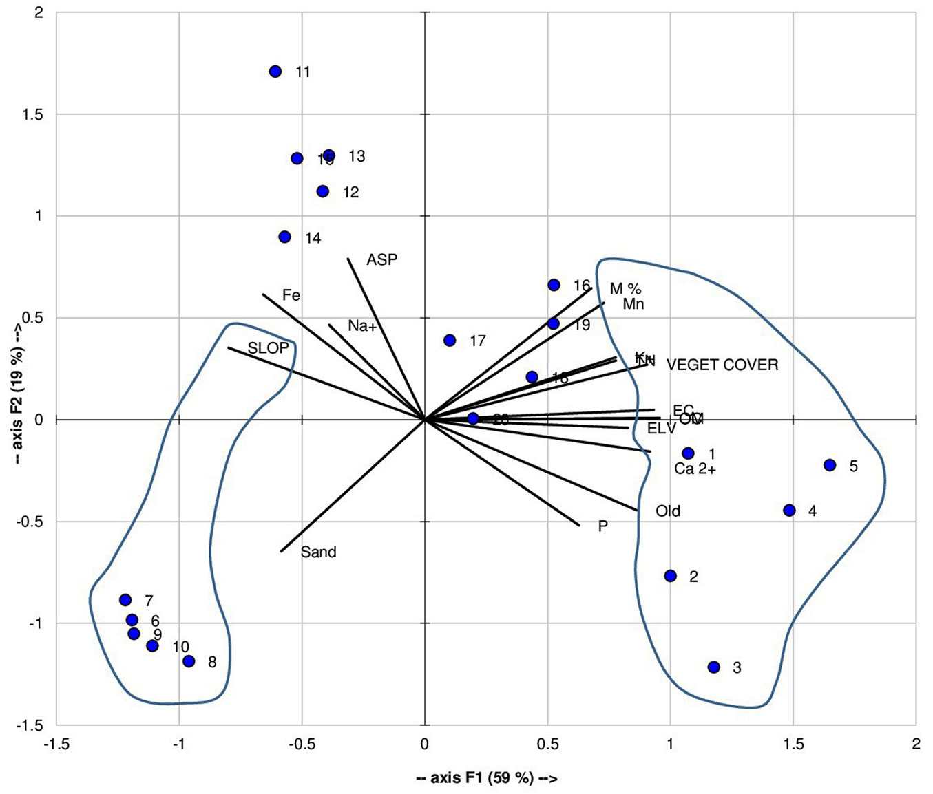
Axis F1 is strongly positively correlated with variables related to soil fertility and quality, in particular M, OC, OM, EC, TN, exchangeable Ca2+, K+, Mn, and vegetation cover (VEGET COVER). Topographic variables such as elevation (ELV) and the number of years since the last fire (Old) also contribute significantly to this axis. Conversely, sandy texture (Sand) and slope (SLOPE) showed marked negative correlations with F1. Axis F2 is mainly structured by the explanatory variable exposure (ASP), which does not show significant correlations with any variables; therefore, it is useful to exclude this axis from the interpretation.
FTIR spectroscopy results
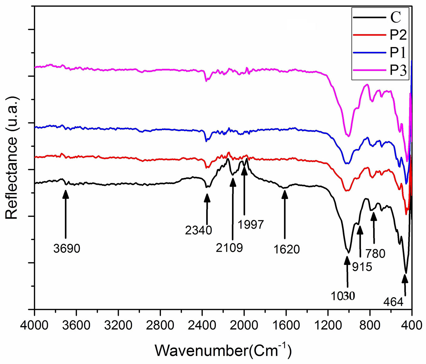
The FTIR spectra of the analyzed soil samples exhibit several absorption bands associated with both mineral and organic components. All samples showed a weak but persistent band at 464 cm-1, indicating the presence of silicate minerals (Fig. 5). The band at 780 cm-1, characteristic of quartz, showed variable intensity among samples and was more pronounced in P3, suggesting a higher relative quartz contribution. Absorption bands between 905 and 915 cm-1 displayed variable intensities across samples, with strong signals in the control (C) and P3 soils and moderate to low intensities in P1 and P2. A pronounced band at 1030 cm-1 was also detected, being particularly intense in the control and P3 samples and less marked in P1 and P2. The spectral region between 1600 and 1650 cm-1 showed a moderately intense band related to organic matter and/or adsorbed water; in the control sample, a distinct band appeared at 1620 cm-1. A weak, very low-intensity band at 1997 cm-1 was observed in all spectra and strata, except P2. In contrast, an intense absorption band at 2109 cm-1, mainly observed in the control soil, and the band around 2340 cm-1 were identified as non-soil-related signals. Finally, bands in the 3650-3700 cm-1 range, corresponding to hydroxyl stretching vibrations, demonstrated variable intensities among samples, with a general decrease in burned soils. Fig. 5shows the FTIR transmittance spectra of four soil samples (P1, P2, P3, and C) as a function of wavenumber (cm-1).
Fig. 5 - FT-IR spectral signature of soil samples.
Soil mineralogy
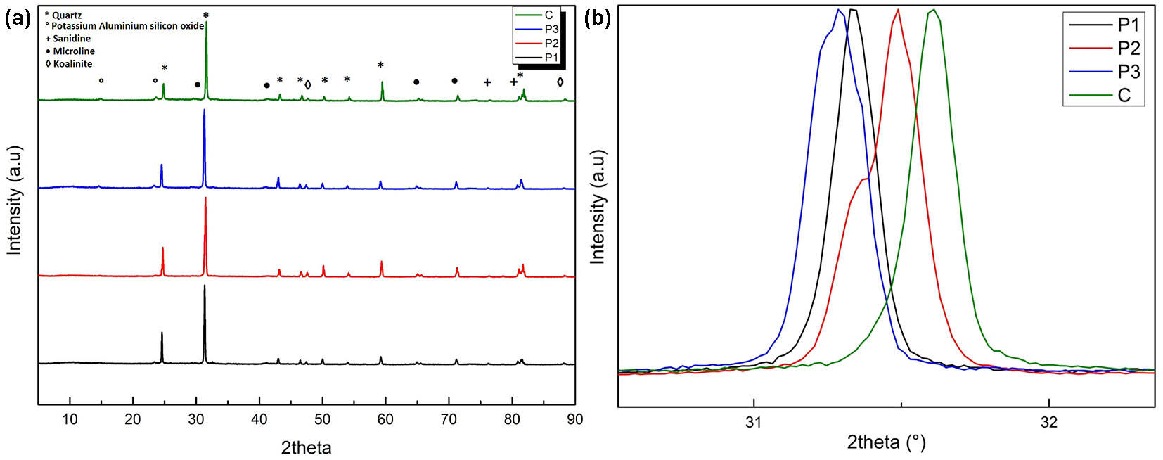
The XRD analysis was conducted on four soil samples collected at different intervals following a wildfire: P1, P2, P3, and C. We performed phase identification using the “diffraction material analysis software” X’Pert HighScore Plus with the PDF4/2022 database. Fig. 6a shows the XRD spectra of the control sample C compared with samples P1, P2, and P3. Tab. 3 presents the corresponding microstructural and crystallographic parameters for the representative intense peaks. The XRD results showed clear, measurable differences in the mineralogical structure of the soils depending on exposure to FF and the time elapsed since the event. These differences were observed in changes in peak width (FWHM), interplanar spacing (Fig. 6b), crystallite size, and microstrain.
Fig. 6 - XRD spectra of the control sample C compared with samples P1, P2, P3 (a). Magnified views and comparison of the main diffraction peaks (b).
Tab. 3 - XRD-derived microstructural parameters of soil samples with and without forest fire exposure.
| Samples | Position | FWHM | D-spacing | Crystallite size |
Microstrain % |
|---|---|---|---|---|---|
| P1 | 24.567 | 0.127 | 4.204 | 722.39 | 0.288 |
| 31.317 | 0.145 | 3.314 | 891.64 | 0.184 | |
| P2 | 24.75 | 0.122 | 4.181 | 930.88 | 0.224 |
| 31.505 | 0.242 | 3.302 | 484.39 | 0.340 | |
| P3 | 24.509 | 0.172 | 4.214 | 667.70 | 0.135 |
| 31.257 | 0.187 | 3.320 | 658.21 | 0.252 | |
| C | 24.810 | 0.161 | 4.163 | 1231.32 | 0.170 |
| 31.580 | 0.149 | 3.287 | 962.31 | 0.172 |
Discussion
The effect of FF on OC and, therefore, on OM may depend on fire duration, soil type, topography, soil M, vegetation type, and vegetation cover ([17]). OC stocks increase with the number of years after the fire (P1, P2, and C). High OC and OM levels in C samples are attributed to greater living above-ground biomass than in burned soils ([34], [2]). However, the low OM content at site P2 may be explained by high nutrient exports and by relatively light textures that cannot accumulate a significant stock of organic matter ([45]). Opinions differ on changes in soil TN content after a forest fire. Some authors estimated that total nitrogen decreases after a forest fire due to volatilization ([29], [34]). Others reported that soil TN levels increase ([36]). Our observations are consistent with those reported by Jacquet & Cheylan ([26]) and Caon et al. ([13]) in the Mediterranean forest, who stated that the amount of TN volatilized during a FF is proportional to the amount of OM lost. Indeed, long-term TN recovery or loss in plots P1, P2, P3, and C was proportional to that of OM and, therefore, OC. P availability in soils increased over time, with the highest value in C, likely due to improved vegetation and soil quality ([2]) and increased OM mineralization. In contrast, other authors ([8], [39]) have reported decreased P content due to vegetation uptake and the difficulty of replenishing it. However, Scharenbroch et al. ([44]) and Valkó et al. ([48]) found no change in P level over time. It has been reported that EC tends to increase immediately after forest fires, due to the release of soluble ions during the combustion of soil and OM, and the incorporation of ash into the soil ([2]). This nutrient availability, which was observed shortly after the fire, can persist long after the ash has settled ([26]). In addition, EC is positively correlated with soil nutrients such as OM, TN, Ca2+, K+, and Na+. Indeed, the increase in nutrients and exchangeable cations, and therefore in EC, in P1 is due not only to enrichment of the soil by deposited ash residues ([20], [23]), but also to vegetation growth and emergence, which increases soil nutrient content. The decrease in EC at site P2 was driven by reduced nutrient content, likely lost through export and drainage into deeper layers ([49], [11]). The dominance of the sandy fraction at site P2 explains the poor quality of these soils, as shown by nutrient leaching ([10]). Sandy material has a low water-retention capacity; however, sandy material behavior could be influenced by the intensity and severity of the fire ([2]), resulting in the collapse of the crystalline structure of clay lattices (e.g., through the loss of hydroxyl ions or dehydration), resulting in the cementation of clay particles and the formation of either silt- or sand-sized new particles ([26], [24]). We could not test this property in our case because we lack information on the history of local fires. Different cations undergo different changes. According to Verma & Jayakumar ([51]), Mg2+ is relatively less sensitive to FF, which can be explained by its high threshold temperatures. The slight decrease in K+, Na+, and Mn stocks observed at site C is probably due to emergent plants using these nutrients ([35]). The high concentrations of trace elements in recently burned sites are attributed to suspended ash ([39]). This shows how forest fires affect Fe forms in forest soils ([12]). Consequently, plants use them over time, reducing their mineral fraction in the soil ([39]).
PCA highlighted soil maturity and stability, showing a major soil gradient and contrasting mature soils. This indicated enhanced organic matter, greater chemical fertility, and developed vegetation cover, while sandy soils on steeper slopes were exposed to erosion and had low nutrient-retention capacity. Discrimination was evident between topographically more active areas, exposed to erosion and remobilization processes, and older, relatively stable areas.
Correlations showed a strong association between edaphic and abiotic ecological factors associated with soil fertility. Overall, soil maturity and vegetation cover were the main factors modulating the spatial dynamics of edaphic properties.
The persistent band at 464 cm-1 in the FTIR results confirmed the dominance of silicate minerals, particularly clay minerals, within the soil matrix, while the band at 780 cm-1 indicated the presence of quartz. The enhanced intensity of this quartz-related band in sample P3 suggested relative quartz enrichment, commonly attributed to post-fire concentration effects driven by OM loss and thermal alteration of fine soil fractions ([30], [52]). High absorptions between 905 and 915 cm-1, together with the pronounced band at 1030 cm-1 in the control and P3 samples, indicated a greater contribution from organic compounds, notably polysaccharides. However, this spectral region overlaps with silicate stretching vibrations, making mineral interference likely in soils with significant clay content. The reduced intensity of these bands in P1 and P2 suggested fire-induced degradation or transformation of labile OM ([30], [37], [41]). The absorption features in the 1600-1650 cm-1 region are commonly associated with aromatic C=C structures of soil OM and/or the bending vibration of adsorbed water. The moderate intensity of the 1620 cm-1 band in the control soil reflects higher moisture content or a greater proportion of aromatic organic compounds. Such bands typically decrease after fire due to dehydration and thermal decomposition of OM ([41]). The very weak band at 1997 cm-1 corresponds to a minor overtone of quartz and has limited interpretative significance compared with the more pronounced fundamental Si-O vibrations at ~1100 or 460 cm-1 ([52]). Finally, the decrease in intensity of hydroxyl stretching bands between 3650 and 3700 cm-1 in burned soils revealed the loss of structural and adsorbed water, as well as the degradation of hydroxyl-bearing organic compounds. This behavior is consistent with fire effects on soil moisture and OM pools, as reported in previous studies ([41], [15]). Thus, the FTIR analysis indicated that FF hinders the short-term recovery of OM quality ([22]).
The C sample, used as the unburned reference, showed relatively sharp diffraction peaks with low FWHM values (0.149°-0.161°), large crystallite sizes (about 962-1231 Å), and moderate microstrain (0.17%). Together, these parameters indicate a well-preserved crystalline structure, typical of soil minerals unaffected by significant thermal stress. In contrast, the P1 sample, collected two years after the forest fire, showed noticeable peak broadening, accompanied by reduced crystallite size and increased microstrain. FWHM values reached up to 0.145°, while crystallite sizes decreased to approximately 722-892 Å. These changes indicate fire-induced microstructural damage, reflected in internal lattice distortion and increased residual stress within the mineral framework. The P2 sample exhibits intermediate but more variable behavior. Some diffraction peaks remain relatively narrow, whereas others are strongly broadened (FWHM up to 0.242°), with a marked decrease in crystallite size (down to ~484 Å) and the highest microstrain values observed (up to 0.340%). This variability suggested that, although partial structural relaxation may occur with time, significant residual strain and disorder persist in certain crystallographic domains. By comparison, the P3 sample, collected from a site that has not been exposed to forest fire for approximately 18 years, showed stable diffraction peaks with moderate FWHM values (0.172-0.187°), relatively uniform crystallite sizes (~658-668 Å), and lower microstrain than those measured in P1 and P2. These characteristics are close to those of reference sample C, indicating that natural aging without fire allows soil minerals to retain a more stable and coherent crystalline structure. Overall, the quantitative XRD parameters demonstrated that forest fire exposure produced long-lasting microstructural changes in soil minerals. While some recovery is observed over time, the data indicate that crystallographic restoration remains incomplete even at the decadal scale.
Conclusion
Comparison between burned and control soils in the Tamgout forest demonstrated that fires hinder the short-term recovery of soil quality, with trajectories strongly controlled by time after fire, soil texture, and vegetation regeneration. Furthermore, results indicated that soil carbon and organic matter stocks generally increase with post-fire age, but their recovery remains limited in sandy soils due to reduced stabilization capacity and enhanced nutrient leaching. Post-fire nutrient availability showed element-specific responses: electrical conductivity and exchangeable cations increase shortly after fire due to ash inputs, then decline due to leaching, while phosphorus availability tends to improve as the ecosystem recovers. Mineralogy in both aged burned soils and controls showed persistent mineral signatures dominated by silicates and quartz, alongside marked alterations in organic functional groups in burned soils, indicating degradation of labile organic matter and loss of hydroxyl-associated water.
This study provided the first data allowing insight into how FF impacts local forest soils. The information provided is necessary to improve forest fire prevention strategies, especially on rough terrain. Therefore, we recommend increasing the number of replicates across strata in future work to better confirm our observations.
Acknowledgments
KS: methodology, data collection, data analysis, statistical analysis, data interpretation, and writing the original draft; ZC: data analysis and visualization; BM: data analysis and visualization; AA: visualization, statistical analysis, literature review, and data interpretation; OZ: visualization, methodology, and literature review. BM: statistical analysis and data interpretation; RM: conceived the methodology, literature review, visualization, supervision, review, and editing.
We thank Sonatrach staff and Azeffoun forest services for their help during the research. Thanks to Prof. Ahmed Latigui and Prof. Tahar Amrouche for their writing assistance.
References
Gscholar
Gscholar
Gscholar
Online | Gscholar
Online | Gscholar
CrossRef | Gscholar
Gscholar
Gscholar
Gscholar
CrossRef | Gscholar
Online | Gscholar
Gscholar
Authors’ Info
Authors’ Affiliation
Boussad Metna 0009-0003-4907-9557
Rachid Meddour 0000-0003-2936-2470
Department of Biology, Faculty of Biology and Agronomy, Mouloud Mammeri University, Tizi Ouzou, 15000 (Algeria)
Ouahid Zanndouche 0009-0002-6768-1368
Soil Science Laboratory, National Forest Research Institute, Bainem, Algiers (Algeria)
Materials Physics Laboratory, Faculty of Physics, University of Science and Technology, University of Houari Boumediene - USTHB, Bab-Ezzouar, B.P. 32.16111 Algiers (Algeria)
Department of Biology, Faculty of Sciences and Technology, University of Relizane, Relizane (Algeria)
Corresponding author
Paper Info
Citation
Sebki K, Chekired ZE, Mehdi B, Allam A, Zanndouche O, Metna B, Meddour R (2026). Post-fire assessment of soil physicochemical properties in Tamgout Forest, Northern Algeria. iForest 19: 403-410. - doi: 10.3832/ifor4956-019
Academic Editor
Davide Ascoli
Paper history
Received: Aug 05, 2025
Accepted: Apr 18, 2026
First online: Nov 09, 2026
Publication Date: Dec 31, 2026
Publication Time: 6.83 months
Copyright Information
© SISEF - The Italian Society of Silviculture and Forest Ecology 2026
Open Access
This article is distributed under the terms of the Creative Commons Attribution-Non Commercial 4.0 International (https://creativecommons.org/licenses/by-nc/4.0/), which permits unrestricted use, distribution, and reproduction in any medium, provided you give appropriate credit to the original author(s) and the source, provide a link to the Creative Commons license, and indicate if changes were made.

Web Metrics
Breakdown by View Type
Article Usage
Total Article Views: 89
(from publication date up to now)
Breakdown by View Type
HTML Page Views: 16
Abstract Page Views: 26
PDF Downloads: 41
Citation/Reference Downloads: 0
XML Downloads: 6
Web Metrics
Days since publication: 1
Overall contacts: 89
Avg. contacts per week: 623.00
Article Citations
Article citations are based on data periodically collected from the Clarivate Web of Science web site
(last update: Jul 2026)
(No citations were found up to date. Please come back later)
Publication Metrics
by Dimensions ©
Articles citing this article
List of the papers citing this article based on CrossRef Cited-by.
Related Contents
iForest Similar Articles
Research Articles
Post-fire effects and short-term regeneration dynamics following high-severity crown fires in a Mediterranean forest
vol. 5, pp. 93-100 (online: 30 May 2012)
Research Articles
Assessing the performance of fire danger indexes in a Mediterranean area
vol. 11, pp. 563-571 (online: 01 September 2018)
Short Communications
Upscaling the estimation of surface-fire rate of spread in maritime pine (Pinus pinaster Ait.) forest
vol. 7, pp. 123-125 (online: 13 January 2014)
Research Articles
The economic value of fire damages in Tuscan agroforestry areas
vol. 14, pp. 41-47 (online: 14 January 2021)
Research Articles
Differences of fire activity and their underlying factors among vegetation formations in Greece
vol. 6, pp. 132-140 (online: 08 April 2013)
Review Papers
Post-fire soil hydrology, water erosion and restoration strategies in Andosols: a review of evidence from the Canary Islands (Spain)
vol. 9, pp. 583-592 (online: 17 March 2016)
Research Articles
Historical fire ecology and its effect on vegetation dynamics of the Lagunas de Montebello National Park, Chiapas, México
vol. 14, pp. 548-559 (online: 01 December 2021)
Research Articles
Wildland fire typologies and extreme temperatures in NE Spain
vol. 10, pp. 9-14 (online: 01 November 2016)
Research Articles
Post-fire recovery of Abies cephalonica forest communities: the case of Mt Parnitha National Park, Attica, Greece
vol. 11, pp. 757-764 (online: 15 November 2018)
Research Articles
Modeling human-caused forest fire ignition for assessing forest fire danger in Austria
vol. 6, pp. 315-325 (online: 16 July 2013)
iForest Database Search
Search By Author
Search By Keyword
Google Scholar Search
Citing Articles
Search By Author
Search By Keywords
PubMed Search
Search By Author
Search By Keyword