Predicted occurrence of ancient coppice woodlands in the Czech Republic
iForest - Biogeosciences and Forestry, Volume 10, Issue 5, Pages 788-795 (2017)
doi: https://doi.org/10.3832/ifor2295-010
Published: Sep 16, 2017 - Copyright © 2017 SISEF
Research Articles
Abstract
Coppicing started in the Neolithic period and has been practiced throughout European history. This traditional silvicultural system was abandoned in many European countries during the 20th century. The Czech Republic now has a very low proportion of coppice woods (CW), as more than 1000 km2 CW were converted into high forests after World War II. Nevertheless, many CW were maintained as stored coppices, which could be the last remainders of ancient coppice woods (ACW) in the Czech Republic. Knowledge of area and distribution of stored coppices is currently missing in the Czech Republic, because they are recorded as high forests in forest management plans. Many stored forests are currently approaching the maturity age, with a high risk that these last ACW remainders will be lost; therefore, an inventory of ancient coppice woods is necessary. In our study, we develop an index of likelihood of coppice occurrence (COP) based on the distribution of habitats favourable for coppices, as well as on past and current occurrence of CW in the Czech Republic from historical maps. COP index values were then used to generate a map showing the relative likelihoods of occurrence of ACW, which can serve as a baseline to support the compilation of an ACW inventory and their mapping in the field. Our results can help prioritize forest areas to be inventoried based on their higher probabilities of ACW occurrence.
Keywords
Ancient Coppice Woodlands, Inventory, Coppice Occurrence, Cultural heritage
Introduction
In Europe, forests and other woodlands occupy 215.422.000 ha, equalling 38.1 % of the land; of this, 27.495.100 ha are coppiced forests ([42]). Thus, the coppice woodlands cover 12.7 % of the wooded area in Europe. However, the distribution of coppice woodlands among European countries is very variable. For example, less than 1 % of the woodlands are coppices in Cyprus, UK, Denmark, Sweden, Poland, Germany, Ireland, Finland, Malta, Estonia, Latvia and Lithuania. On the other hand, coppices represent more than 10 % of the woodlands in Greece, Italy, France, Bulgaria, Hungary, Spain, Portugal, Luxembourg, Belgium and Slovenia ([15]).
Much of the existing coppice woodlands are characterized as ancient woodlands ([30]). Coppicing ([26], [41]) and pollarding ([22]) were in widespread use as silvicultural systems until the beginning of the 20th century, as shown by their frequent depiction in visual arts from this period ([18]). The first evidence of coppicing from the territory of the Czech Republic dates back to the year 1384 ([26]). However, coppices had been in use much earlier, with dendroarchaeological research revealing that coppicing started in the Neolithic and has been practiced throughout the European history ([37]). Brown & Oosterhuis ([7]) used the term “ancient coppice woods” to describe woodlands that had been continuously coppiced since at least the year 1800 AD. Similarly, the appearance of coppices with standards ([43]) was documented as first occurring in Germany in 600 AD and in France in the Middle Ages, and there are records from the 12th century from England ([24]). In Eastern European countries, the system was also well known since the Middle Ages ([19]).
In ancient woodlands, natural processes interact with human activities in complex and subtle ways for centuries or millennia ([27]). Glaves et al. ([12]) listed a wide range of ancient woodland values, including biodiversity, rarity, history and irreplaceability. There are three broad types of feature to look for in ancient woodland according to Glaves et al. ([12]): (i) vascular plant indicators; (ii) tree shape and form; and (iii) surface and buried archaeology.
Many ancient woods hold amazingly rich resources of archaeology and local history ([32]) that are only little altered by modern cultivation or disturbance ([2]). For example, Szabó ([38]) mentioned that in Western and Central Europe, many ancient woods are clearly separated from the surrounding countryside by permanent physical boundaries. While such boundaries (woodbanks, walls, stone rows and lynchets) are now out of use, they were widespread and important landscape features in the past.
The main component of ancient coppice woodlands is the presence of ancient coppice stools, which can reach 1000 years in age and demonstrate the long-term continuity of coppicing ([29], [28], [46]). In addition to the ancient coppice stools, the presence of tree microhabitats ([47]), especially water filled cavities (dendrotelms - [16]) are among the important natural features increasing biodiversity. The ancient coppice woodlands are often species-rich and host many globally threatened plant and animal species ([31]). Stand-scale survival of light-demanding species and their coexistence with shade-tolerant species is ensured by the shifting mosaic of different-aged patches created by coppicing ([10]). Over-aged coppice stands provide important habitat conditions for saproxylic species and unique herbaceous layers ([23]). Coppicing and wood-pasture have resulted in woodland habitats that are nowadays highly valued for nature conservation due to their rich biodiversity ([25]). Most forest habitats listed in the Habitats Directive of the European Union (Council Directive 92/43/ EEC) for their nature conservation importance result from centuries of human intervention. Mairota et al. ([20]) proposed a list of 53 forest habitat types (68% of the 78 Annex I forest habitat types) capable of being managed as coppices. The majority (55%) fall into “9100 Forests of Temperate Europe”.
The demise of traditional forest management, in particular its most widespread form - coppicing, is considered to be a driver of forest biodiversity decrease ([14]), resulting in changes in both plant communities ([14], [17], [25]) and invertebrate populations ([3]). Indeed, the occurrence of red-list species diminishes considerably after coppice abandonment ([25]).
Coppicing was abandoned in many European countries during the 20th century ([26]). Most coppice woods were converted into high forests. To stop the process of diminishing biodiversity and support the goals of nature conservation, Müllerová et al. ([25]) proposed the re-establishment of coppice management. This is not possible without an inventory of existing ancient coppice woodlands ([33]).
In the Czech Republic, Kadavy et al. ([15]) described only 7000 ha of coppice forests in 1990 (0.3 % of the forest area); however, most of them are not ancient, for example Robinia pseudoacacia (Black locust) coppice woods. On the other hand, many coppice woods were converted into stored coppices (i.e., overaged coppices) and if there are any well-preserved coppice stools, we can regard them as ancient coppice woods and suppose the presence of other natural and historical elements. The conversion and abandonment of coppice woods culminated in the Czech Republic after World War II, meaning that many of their remainders and stored coppice are currently approaching maturity. There is a great risk that these last remainders of the ancient coppice woods will be lost.
No historical maps from before 1941 are available for the whole area of the Czech Republic to document coppice woodland distribution and continuity, and thus to prove the existence of ancient coppice woodlands. The present paper aims at creating a set of maps of historical, present and potential occurrences (based on favourable habitat) of coppice woodlands in order to infer the likely distribution of remaining ancient coppice woodlands in the Czech Republic. This distribution would help prioritise areas to be included in the field inventory and subsequent conservation of ancient coppices.
Material and methods
Study area
We focused on the whole area of the Czech Republic (centroid coordinates: 49.78° N, 15.67° E), which covers 78.866 km2. Of this area, 34% is covered by forests. The altitude varies from 115 to 1603 m a.s.l., mean annual temperature from 2 to 10 °C and mean annual sum of precipitation from 450 to 1200 mm. Within the geobiocoenological classification of forests ([8]), nine altitudinal vegetation zones are distinguished according to prevailing tree species. From lowlands to mountains, the prevailing species are: Quercus spp. (oak), Fagus sylvatica (European beech), Abies alba (silver fir) and Picea abies (Norway spruce). The territory of the Czech Republic is divided into more than 13.000 cadastral areas. The cadastral areas are grouped into 206 administrative districts known as “Municipalities with Extended Competence” (hereinafter MECs) within two geographically different regions: Bohemia (western part) and Moravia (eastern part of the Czech Republic).
Input data
We collected data for all the cadastral areas of the Czech Republic, although several data were not available at the cadastral area level and were collected directly at the MEC level. All input data were finally summarised and analysed at the MEC level. In addition, appropriate maps were created based on the MEC layer (Source: ARC CR 500).
For each MEC, we estimated both its total area of forest land and its absolute area of ACW by combining different data sources with the methodology described below. This enabled to compare MECs based on the proportions of their forested land occupied by ACW, thus eliminating the influence of MEC size. We also assigned the woodlands in each MEC to suitability classes for ACW establishment (based on natural conditions) and calculated, across MECs, the mean percentage MEC woodlands in each suitability class.
Natural conditions
We used altitudinal vegetation zones (AVZs) as the main information source on natural conditions influencing the occurrence of coppice woodlands for three main reasons. First, they carried information about the main tree species in forest species composition, which is a crucial prerequisite for coppicing, as tree species differ in sprouting ability ([5]). Second, there is a long history of AVZ mapping in the Czech Republic, resulting in detailed information available on AVZs for the whole country (e.g., stored in the biogeography register, which is a database where information about AVZ distribution is stored at the cadastral areas level - [45]). Third, the characterization of AVZs contains information about climatic conditions, which are the main driver influencing coppices distribution ([41]). The gradient in tree species composition ranges from good resprouters at lower altitudes and low AVZs (e.g., oaks and hornbeam - Carpinus betulus) to a worse resprouter (beech) and finally to non-resprouters (the conifers silver fir and Norway spruce) at higher altitudes in mountains.
To obtain information about AVZs for the whole Czech Republic, we used the biogeography register ([45]). In particular, this register contains information about the representation of AVZs for each cadastral area, using 26 codes of which seven include only one AVZ and 19 are heterogeneous, combining more than one AVZ.
To evaluate natural conditions favourable for the establishment of coppice woodlands, we classified the AVZ codes into five categories (A-E) according to prevailing tree species and assigned them relative weights based on their relative suitability for coppice woodlands. Very favourable natural conditions for the establishment of coppice woodlands (category A) were expected in AVZs with oak as a prevailing species, i.e., in AVZ 1 (“Oak”) and AVZ 2 (“Beech-Oak”, mainly oak with an admixture of beech), and favourable natural conditions (category B) where oak has a considerable representation (AVZ 3, “Oak-Beech”, mainly beech with an admixture of oak). In these two categories, natural forest biocoenoses enable coppice establishment not only because of the abundance of oak, which is a good resprouter, but also because they contain significant amounts of hornbeam, which resprouts even better than oak ([21]). The less-favourable (category C, AVZ 4) and unfavourable (category D, AVZ 5) both feature AVZs in which beech is dominant. Beech is a tree species with lower resprouting ability than oak ([11]), and the AVZs falling in this category are not accompanied by large representations of oak or hornbeam. Very unfavourable conditions (category E) comprise AVZs (AVZ 6 and higher) with a significant share or dominance of the conifer species Norway spruce or silver fir.
For each MEC, we extracted the percentage of total area in each AVZ category, multiplied it by the weight of the category and summed those values to obtain one number for the MEC, which we called its NC (Natural Conditions) index. Weights were assigned based on the assumption that the probability of establishing coppice woodlands in unfavourable conditions would be ten times less likely than in very favourable conditions; this was based on our observations gathered while field mapping ACW in different altitudinal vegetation zones (manuscript in preparation). The weights are shown in the following equation used to calculate the NC index values (eqn. 1):
where A, B, C, D, E are percentage shares of areas of the individual categories of natural conditions in MECs. NC index values range from 0-10. The whole gradient of NC index values was finally divided into intervals used to characterize the potential for establishment of coppice woodlands in each MEC: (i) very unfavourable: 0.0-0.8; (ii) unfavourable: 0.9-2.6; (iii) less favourable: 2.7-5.3; (iv) favourable: 5.4-8.0; (v) very favourable: 8.1-10.0.
Historical occurrence of coppice woodlands
Coppice woodlands area in 1845
To obtain information about occurrence of coppice woodlands in the mid-19th century, we used land use registry records from 1845 which are available for each cadastral area. These records are based on results of the mapping of stable cadastres (over the period 1826-1843) at the scale 1:2880 ([4]). For forests, they list areas of high forests (divided into broadleaved, coniferous and mixed), coppice woods, glades, shrublands, landscape parks and burnt-over areas. Thus, they constitute a unique source of information about the condition of forest stands for this period. They are now publicly available on the web (⇒ http://archivnimapy.cuzk.cz), from which we manually gathered the information on the area of coppice woods for all of the over 13.000 cadastres and stored this information in our database.
Area of coppice and oak woodlands in 1941 and 1947
We next gathered information about coppice woodlands and oak woodlands distribution about 100 years later, as provided in two maps - one from 1941 ([36]), and one from 1947 ([35]). On both maps, the main tree species composition (e.g., oak forest) and designation as coppice vs. high forest are indicated. We were interested both in areas designated as coppices and those indicated to be oak woodlands. The map from 1941 covers about 92% of the area of the Czech Republic, and that from 1947 encompasses its whole area. Both maps are available as just a few original copies and with rather uncertain purpose and methodology of their creation. The map from 1947 is probably derived from first one.
Both maps were digitized on a high-resolution large-format scanner and georeferenced, and then all polygons containing coppice and oak woodlands were manually vectorized. We used information about coppice and oak woodlands occurrence from the map from 1941, and then used the map from 1947 just for the area not covered by the map from 1941. The results were two maps, one with coppices in 1941/1947 and one with oak woodlands in 1941/1947.
Current occurrence of coppice woodlands
We used two sources for current occurrence of coppice woodlands: the Natura 2000 list of habitats and comprehensive forest management plans. Both sources were useful but limited. Indeed, Natura 2000 was not designed to collect information about forest management practices, neither present nor past (high forest/coppice). Forest management plans, on the other hand, often listed stored coppices as high forests because they were the preferable management practice from the mid-20th century.
Natura 2000 habitats
Mapping of habitat types for Natura 2000 ([9]) was carried out in the whole Czech Republic in 2001-2004 and has been continually updated since 2006. As a result, Natura 2000 maps contain relatively accurate and up-to-date information about the habitat types included in the habitat type catalogue of the Czech Republic ([9]), although coppices (or stored coppices) and high forest are not distinguished in these maps. Nevertheless, we were able to deduce the likelihood of each habitat type consisting of coppices (including stored coppices). First, we chose all habitat types for which coppice occurrence is possible by the representation of tree species able to resprout mentioned in the habitat types description (22 such habitat types in total). Although some of these habitat types often consist of (primarily stored) coppices (e.g., oak-hornbeam forests), some of them contain actual or stored coppices in only very few cases (e.g., limestone beech forest). Therefore, in the second step we estimated the probability each of these habitats to include (actual or stored) coppices (Tab. 1). These probabilities were determined by repeated assessment by experts with long-term experience in habitat mapping, and they were multiplied by the area of each particular habitat type in MEC, weighting them accordingly.
Tab. 1 - Types of habitats listed in Natura 2000 ([9]) with estimated probabilities (%) of occurrence of coppice woods (Prob.).
| Code | Habitat type | Prob. (%) |
|---|---|---|
| K3 | Tall mesic and xeric scrub | 5 |
| L1 | Alder carrs | 10 |
| L2.2 | Ash-alder alluvial forests | 15 |
| L2.3 | Hardwood forests of lowland rivers | 10 |
| L2.4 | Willow-poplar forests of lowland river | 20 |
| L3.1 | Hercynian oak-hornbeam forests | 50 |
| L3.2 | Polonian oak-hornbeam forests | 60 |
| L3.3 | Carpathian oak-hornbeam forests | 50 |
| L3.4 | Pannonian oak-hornbeam forests | 75 |
| L4 | Ravine forests | 10 |
| L5.1 | Herb-rich beech forests | 0.5 |
| L5.3 | Limestone beech forests | 1 |
| L5.4 | Acidophilous beech forests | 0.5 |
| L6.1 | Peri-alpidic thermophilous oak forests | 90 |
| L6.2 | Pannonian thermophilous oak forests on loess | 70 |
| L6.3 | Pannonian thermophilous oak forests on sand | 50 |
| L6.4 | Central European basiphilous thermophilous oak forests | 50 |
| L6.5 | Acidophilous thermophilous oak forests | 80 |
| L7.1 | Dry acidophilous oak forests | 50 |
| L7.2 | Wet acidophilous oak forests | 50 |
| L7.3 | Subcontinental pine-oak forests | 1 |
| L7.4 | Acidophilous oak forests on sand | 50 |
For each MEC, the current areas of selected Natura 2000 habitat types were obtained from the Nature and Landscape Conservation Agency of the Czech Republic, multiplied by their weighting factors (from Tab. 1) and summed to obtain the estimated current occurrence of coppice woods within it.
Comprehensive forest management plans
We next obtained information on locations and areas of forests listed as coppice woods and coppices with standards from the database of comprehensive forest management plans administered by the Forest Management Institute in Brandýs nad Labem. We used these data to calculate the area of coppices and coppices with standards in each MEC. Although comprehensive forest management plans contained directly information about coppicing, they lacked many stored coppices ([15]).
Data synthesis
Tab. 2 - Summary of criteria used to calculate COP index reflecting the potential for AWC occurrence in MECs. (Range): range of values in MECs; (Total points): total points in all MECs.
| Criteria | Label | Source | Value | Range | Total points |
|---|---|---|---|---|---|
| Natural conditions for coppice woodland establishment | NC index | Biogeography register ([45]) |
NC Index | 0-10 | 717.1 |
| Area of coppice woods in 1845 | C_area1845 | Land use registry records from stable cadastre |
Area (km2) | 0-76.87 | 1457.27 |
| Area of coppice woods in 1941/1947 | C_area1941 | Maps from 1941 and 1947 ([36], [35]) |
Area (km2) | 0-59.29 | 1031.79 |
| Area of oak woods in 1941/1947 | Oak_area1941 | Maps from 1941 and 1947 ([36], [35]) |
Area (km2) | 0-25.7 | 226.72 |
| Current area of coppice woods and coppice with standards according to forestry records |
C_forestry | Comprehensive forest management plans | Area (km2) | 0-16.86 | 109.88 |
| Area of Natura 2000 biotopes with inferred occurrence of coppice woodlands |
C_Natura | Natura 2000 habitats distribution database | Area (km2) | 0.21-56.18 | 1390.68 |
We synthesized all the above-mentioned input data (overviewed in Tab. 2), constructing an index that we called the COP index. The COP index was calculated for each MEC simply by summing the value of the NC index, the areas of coppice woods from each period/source and half the area of oak woods in 1941/1947, as follows (eqn. 2):
(for abbreviations see Tab. 2). The area of oak woods (and thus its weight in the calculation) was divided by two in the index formula to reflect the uncertainty regarding to what extent the oak forests in 1941/ 1947 were in fact coppices.
Finally, the range of COP values was divided into classes reflecting the inferred likelihood of occurrence of ancient coppice woodlands (ACW) in a given MEC. These likelihoods were inferred based upon several MECs where we mapped the actual distribution of ACWs in the field (data not shown). The classes of predicted occurrence of ACW were as follows: (i) very low: COP index values 0.43-10.00; (ii) low: 10.01-25.00; (iii) moderate: 25.01-50.00; (iv) high: 50.01-100.00; (v) very high: 100.01-175.00.
Results
Natural conditions for the establishment of coppice woodlands
The best natural conditions for the establishment of coppice woodlands (Fig. 1) are in MECs with NC index values reaching the maximum (10.00) because they are located entirely in the altitudinal vegetation zones 1 (Oak) and 2 (Beech-Oak). These include three MECs in Bohemia, and six MECs in Moravia.
Fig. 1 - Map of natural conditions for the potential establishment of coppice woodlands in the Czech Republic.
More than a quarter of the Czech territory (27.4 %) exhibits very favourable or favourable natural conditions for the establishment of coppice woodlands. However, these areas also feature a very low percentage of forest land, considerably below the national average. Specifically, the regions with very favourable or favourable conditions for the establishment of coppice woodlands show percentages of forest land only 18.0 % and 25.0 %, respectively, and their total present-day forest area amounts to 4733.4 km2 (17.7 % of the area of Czech forests - Tab. 3).
Tab. 3 - Number of MECs, areas of MECs and forest areas in MECs by individual NC index classes, i.e., according to natural condition for establishment of coppice woodlands (in %).
| Natural conditions for coppice establishment |
NC Index |
MECs Number (%) |
MECs Area (%) |
Forest area in MECs (%) |
|---|---|---|---|---|
| Very unfavourable | 0.00-0.83 | 24.7 | 27.1 | 44.8 |
| Unfavourable | 0.84-2.59 | 30.6 | 31.1 | 35.0 |
| Less favourable | 2.60-5.30 | 15.0 | 14.4 | 33.2 |
| Favourable | 5.31-8.06 | 15.5 | 15.1 | 25.0 |
| Very favourable | 8.07-10.00 | 14.1 | 12.3 | 18.0 |
Area of coppice woods in 1845
The total detected area of coppice woods in 1845 amounted to 1457.4 km2. It is rather surprising that only two MECs did not show any occurrence of coppice woods in that period. More than 1000 ha of coppice woods occurred in 44 MECs (over 25 %). Thus, the coppice woods were recorded at least as small parcels across nearly the whole territory of the Czech Republic (Fig. 2).
Fig. 2 - Map of the area of coppice woods in the Czech Republic in 1845.
Area of coppice and oak woods in 1941 and 1947
The total area of coppice woods in 1941 and 1947 (Fig. 3) amounted to 1031.791 km2. In this period, 111 MECs (i.e., more than 50 %) already reported no areas of coppice woods, and only 10 % of MECs had areas of coppice over 1000 ha.
Fig. 3 - Map of coppice woods in 1947 (a) and map of oak woods in 1947 (b) in the Czech Republic.
The area of oak woodlands reached 453.4 km 2 in this period (Fig. 3). Although the oak woods are not specified as coppice woods in the maps from 1941 and 1947, many of them were probably of coppice origin, and some still likely managed by coppicing.
Estimated occurrence of coppice woods based on Natura 2000 habitats
We estimate the current occurrence of coppice woods (Fig. 4) based on Natura 2000 habitats to total 1390.7 km 2 in the territory of the Czech Republic. All MECs feature at least a small area of habitat types that could harbour coppice woods. More than 1000 ha of such habitat occurs in each of 46 MECs (i.e., more than 25 % of all MECs). The values are very close to those indicating the historical occurrence of coppice woods.
Fig. 4 - Map of estimated occurrence of coppice woods based on NATURA 2000 habitats (a) and map of current occurrence of coppice woods and coppice with standards based on comprehensive forest management plans (b).
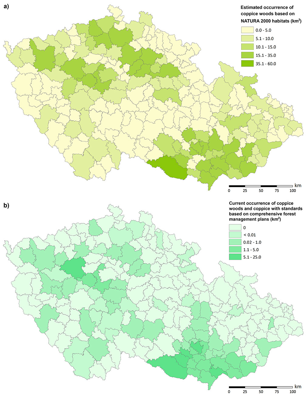
Current area of coppice woods and coppices with standards according to comprehensive forest management plans
Data from forest management plans indicate the area of coppice woods and coppice with standards (i.e., the forest area in which the coppice system of management is actively used - Fig. 4) is 109.9 km2 (92.28 km2 and 17.60 km2, respectively). Forests of these two types are missing in 137 MECs (more than 60 %). In the majority of the MECs in which they do occur, they occupy areas smaller than 1 km2, and only 18 MECs (less than 10 %) currently feature areas of coppice woods and coppice with standards larger than 1 km2. Most coppice woods and coppices with standards recorded in the Forest Management Institute database are concentrated in traditional coppicing regions, i.e., the hilly areas of central Bohemia and the lowlands and hilly areas of southern Moravia.
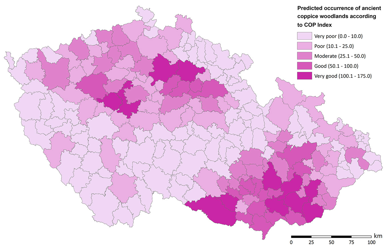
Predicted occurrence of ancient coppice woodlands
The final map created according to the COP index shows the predicted occurrence of ancient coppice woodlands (Fig. 5); where higher COP index values in MECs indicate larger areas of ancient coppice woodlands. Very high COP values were found for 12 MECs (total area 6850.3 km2) with a total of 1939.4 km2 of forests. High COP values apply to 17 MECs (total area 6492.0 km2) with 1574.1 km2 of forests, and moderate COP values were obtained for 28 MECs (total area 9963.8 km2) with 2840.9 km2 of forests. On the other hand, very low COP values were found for 99 MECs (total area 34911.8 km2) with 13.216.0 km2 of forests, and low COP values were found for 50 MECs (total area: 20.648.8 km2) with 7093.4 km2 of forests. These values are expressed as percentages in Tab. 4.
Fig. 5 - Map of predicted occurrence of ancient coppice woodlands in the Czech Republic, according to the COP Index.
Tab. 4 - Number of MECs, area of MECs and forest area in MECs by individual COP index classes, i.e. according to predicted occurrence of ancient coppice woodlands (in %).
| Predicted ACW occurrence |
COP Index class |
MECs Number (%) |
MECs Area (%) |
Forest area in MECs (%) |
|---|---|---|---|---|
| Very low | 0-10.0 | 48.1 | 44.3 | 49.6 |
| Low | 10.1-25.0 | 24.3 | 26.2 | 26.6 |
| Moderate | 25.1-50.0 | 13.6 | 12.6 | 10.7 |
| High | 50.1-100.0 | 8.3 | 8.2 | 5.9 |
| Very high | 100.1-175.0 | 5.8 | 8.7 | 7.3 |
Dscussion
Coppicing and pollarding were the most widespread historical silvicultural systems in broadleaved forests of the European part of the deciduous temperate forest zone from Neolithic times until the early 20th century ([22], [34], [37], [26], [41]), when they were abandoned in many European countries ([39], [40], [25]). The decrease in coppicing is well documented by our source data, as coppice woodlands occurred on an area of 1457.4 km2 in 1845 and only 109.9 km2 in 2013. In most Central and North-Western European countries (where coppice woodlands were dramatically transformed into high forests), coppice woodlands and especially stored coppices and coppices with standards are now considered from a biodiversity conservation perspective as valuable forest habitat, providing important conditions for saproxylic species and a unique herbaceous layer ([23]). However, scientifically-trained foresters in the 19th and 20th century apparently associated traditional management forms (including coppicing) with degradation and depletion, and also with poor timber quality ([44]).
Nowadays, a similar preference for non-coppice woodlands is fairly common in those European countries that still have high proportions of coppice forests. For example, in the Umbria region (Central Italy) a number of conservation plans recommend the conversion to high forest for Natura 2000 specific forest habitat types ([20]). Thus, it appears that the biodiversity benefits of coppices that are now recognized in countries which suffered from their loss are not yet appreciated in countries where coppices are still relatively abundant.
The situation in the Czech Republic is more complicated. Although the benefits of ACW are appreciated by conservationists, most foresters still consider coppices as poor quality and undesirable woodlands, and are thus not involved in efforts to re-establish coppicing. This outlook is likely due to the fact that 100% of forests were in state ownership until as recently as 1989. In contrast, coppice structures have persisted in the Osnabrück region (NW Germany) until today, which Mölder ([23]) mainly attributed to the low economic importance of small private forest parcels, as well as the individualism of the forest owners.
Based on a careful study of archival sources, Szabó et al. ([41]) argued that coppicing was not only widespread in the lowland regions of Moravia in the Late Middle Ages but also rather predominant or even exclusive. Practically every lowland wood was intensively managed by coppicing. Szabó et al. ([41]) calculated the area of woodlands needed to obtain firewood to be 4500 km 2 in Moravia in the Late Middle Ages (15/16th century). Most of that area probably consisted of coppices. Our results show that in 1845 there were only 1457.4 km2 of coppice woodlands in the current territory of the Czech Republic, suggesting that the decrease in coppices started before 1845. The area of coppice woodlands in 1845 estimated in this study is in good agreement with the historical data on the distribution of coppice woodlands in the Czech Republic; according to the revised cadastre from 1900 it was 1550 km 2 ([15]) of which 950 km2 were coppice woodlands and 600 km2 coppices with standards. These data suggest that the conversion of coppice woodlands into high forests began before the 19th century. Already in the 17th century, the practice of selecting coppice stools for conversion to stored coppices was recorded in management instructions ([26]).
In countries where the conversion of most coppice woods into high forests has been completed, there is a danger of losing biodiversity ([6]). For the Czech Republic, we estimated 1390.7 km2 of coppice woodlands (mostly stored coppices), found within 22 Natura 2000 habitat types (as listed by [9]), i.e., 58 % of the forest habitat types in the country. Mairota et al. ([20]) found that there were 53 EUNIS Database habitat types with potential for coppice within the 28 EU member countries, of which 11 types were found to potentially be coppiced in the Czech Republic. The characterization of EUNIS habitat types is generally broader than that of habitat types published for the Czech Republic by Chytry et al. ([9]). This largely explains the greater number of Natura 2000 habitat types that we found to likely contain coppices. According to our estimation, on average, 38 % of area of the 22 mentioned Natura 2000 habitat types (Tab. 2) could be covered by coppice (mostly stored coppice).
Similarly, the cultural and historical heritage relating to ancient coppice woodlands could be threatened ([32], [38]). The failure to identify ancient coppice woodlands may result in accidental damage to the sites by management activities, which could otherwise be avoided ([32]). Thus, especially in stored coppices, the small archaeological features such as boundary stones, boundary trees, old paths, woodbanks, walls, stone rows, lynchets ([38]) could be destroyed by harvesting.
To conserve the natural and cultural heritages associated with ancient woodlands, the Nature Conservation Council of Great Britain created an ancient woodlands inventory in the 1980s. Ascertaining and maintaining the condition of ancient woodland in Great Britain will be a major challenge for the future ([13]) . The inventory forms the basis for more detailed follow-up surveys and contributes to the development of woodland conservation policies. It provides a baseline against which the success of these policies can be monitored ([33]). In the Czech Republic, there is a similar need for an inventory of ancient coppice woodlands because their remainders will reach maturity soon, thus they will be harvested in the near future and replaced by high forests.
Our approach combines both historical and environmental data. Our predictions of the occurrence of ancient coppice woodlands is based on the evaluation of historical, current and potential coppice woodland distributions within MECs. We combined all these sources to generate information about possible occurrence of ancient coppice woodlands that was as accurate as possible. Each of these sources has some weakness when considered individually. Current records of coppice woodland occurrence are very sparse and many stored coppices have been likely reported as high forests by forest managers ([15]). Although historical records go back to the 14th century ([26]) they are dispersed in archives and do not cover all area of the Czech Republic. In fact, the only available map of historical distribution of coppices comes from 1941 ([36]).
Szabó et al. ([41]) published their predictive model of potential Late Middle Ages coppice distribution in Moravia based on studies of archival data. For the period between their map (only for the Moravian part of the Czech Republic) and Svoboda´s map from 1941, we have no comprehensive information about coppice distribution from the territory of the Czech Republic. Our map of coppice distribution in 1845 is therefore very valuable and extends our knowledge 100 years deeper into the past. To fill the gap in our knowledge in historical distribution of coppice woodlands before 1845 we constructed the map of natural conditions for the establishment of coppice woodlands based on the developed NC index. Because ancient forests are defined as forest sites continuously wooded since at least 200 years, we developed another way to predict where ancient coppice woodlands are likely to be found among the current forest area. The resulting map constructed using the COP index clearly shows regions with a higher inferred probability of occurrence of ancient coppice woodlands. It is these areas where the inventory should be of the highest priority.
Human influence through forest management is likely to have contributed to the long-term presence of oak in European woodlands ([1]), especially in ancient coppice woodlands. Sustainable management of coppice woodlands resources could be achieved by both considering the traditional management concepts and introducing new ecologically, economically and socially sound management practices ([34]), as well as by a close cooperation of various state authorities and non-governmental organizations at all levels (local, regional and national).
Conclusions
The Czech Republic is among the countries in which only very small proportions of woodlands are coppiced. In fact, more than 1000 km2 coppice woods were converted into high forest and stored coppices after World War II. These stored coppices could be the last remainders of ancient coppice woods. The area and distribution of stored coppices is not known in the Czech Republic, because they are often recorded as high forests in forest management plans. Therefore, an inventory of ancient coppice woods is necessary.
The map of predicted occurrence of ancient coppice woodlands based on the COP index could serve as a baseline to support planning of their effective inventory and mapping in the field. The map can help prioritize areas to inventory based on their high probabilities of containing ancient coppice woodlands.
Acknowledgements
This work has been financed by the Ministry of Culture of the Czech Republic through the project “Ancient coppice woodlands and their significance and sustainability in the cultural landscape” (DF13P01OVV015). The authors would like to express their gratitude to Jonathan Rosenthal for his thorough English revision of the original manuscript.
References
Gscholar
Gscholar
Gscholar
Online | Gscholar
Gscholar
Gscholar
Gscholar
Gscholar
Gscholar
Gscholar
Gscholar
Gscholar
Gscholar
Authors’ Info
Authors’ Affiliation
Martin Machala
Tomáš Slach
Michal Friedl
Linda Cernušáková
Daniel Volarík
Antonín Buček
Department of Forest Botany, Dendrology and Geobiocoenology, Faculty of Forestry and Wood Technology, Mendel University in Brno, Zemedelská 3, 613 00 Brno (Czech Republic)
Corresponding author
Paper Info
Citation
Madera P, Machala M, Slach T, Friedl M, Cernušáková L, Volarík D, Buček A (2017). Predicted occurrence of ancient coppice woodlands in the Czech Republic. iForest 10: 788-795. - doi: 10.3832/ifor2295-010
Academic Editor
Tomás Vrska
Paper history
Received: Nov 25, 2016
Accepted: Jun 16, 2017
First online: Sep 16, 2017
Publication Date: Oct 31, 2017
Publication Time: 3.07 months
Copyright Information
© SISEF - The Italian Society of Silviculture and Forest Ecology 2017
Open Access
This article is distributed under the terms of the Creative Commons Attribution-Non Commercial 4.0 International (https://creativecommons.org/licenses/by-nc/4.0/), which permits unrestricted use, distribution, and reproduction in any medium, provided you give appropriate credit to the original author(s) and the source, provide a link to the Creative Commons license, and indicate if changes were made.

Web Metrics
Breakdown by View Type
Article Usage
Total Article Views: 50921
(from publication date up to now)
Breakdown by View Type
HTML Page Views: 42222
Abstract Page Views: 3789
PDF Downloads: 3784
Citation/Reference Downloads: 14
XML Downloads: 1112
Web Metrics
Days since publication: 3226
Overall contacts: 50921
Avg. contacts per week: 110.49
Article Citations
Article citations are based on data periodically collected from the Clarivate Web of Science web site
(last update: Mar 2025)
Total number of cites (since 2017): 13
Average cites per year: 1.44
Publication Metrics
by Dimensions ©
Articles citing this article
List of the papers citing this article based on CrossRef Cited-by.
Related Contents
iForest Similar Articles
Review Papers
Opportunities for coppice management at the landscape level: the Italian experience
vol. 9, pp. 775-782 (online: 04 August 2016)
Research Articles
500 years of coppice-with-standards management in Meerdaal Forest (Central Belgium)
vol. 9, pp. 509-517 (online: 17 March 2016)
Research Articles
Effects of traditional coppice practices and microsite conditions on tree health in a European beech forest at its southernmost range
vol. 9, pp. 673-681 (online: 12 March 2016)
Research Articles
Saproxylic beetles in non-intervention and coppice-with-standards restoration management in Meerdaal forest (Belgium): an exploratory analysis
vol. 9, pp. 536-545 (online: 25 March 2016)
Review Papers
Structure and management of beech (Fagus sylvatica L.) forests in Italy
vol. 2, pp. 105-113 (online: 10 June 2009)
Research Articles
Below- and above-ground biomass, structure and patterns in ancient lowland coppices
vol. 10, pp. 23-31 (online: 06 November 2016)
Research Articles
Integrating conservation objectives into forest management: coppice management and forest habitats in Natura 2000 sites
vol. 9, pp. 560-568 (online: 12 May 2016)
Research Articles
Small forest parcels, management diversity and valuable coppice habitats: an 18th century political compromise in the Osnabrück region (NW Germany) and its long-lasting legacy
vol. 9, pp. 518-528 (online: 17 March 2016)
Research Articles
Tree-oriented silviculture: a new approach for coppice stands
vol. 9, pp. 791-800 (online: 04 August 2016)
Short Communications
Respiratory costs of woody tissues in a Quercus pyrenaica coppice
vol. 11, pp. 437-441 (online: 18 June 2018)
iForest Database Search
Search By Author
Search By Keyword
Google Scholar Search
Citing Articles
Search By Author
Search By Keywords
PubMed Search
Search By Author
Search By Keyword


