Predicting tree crown defoliation using color-infrared orthophoto maps
M Eigirdas (1) , A Augustaitis (2), G Mozgeris (3)
iForest - Biogeosciences and Forestry, Volume 6, Issue 1, Pages 23-29 (2013)
doi: https://doi.org/10.3832/ifor0721-006
Published: Jan 14, 2013 - Copyright © 2013 SISEF
Research Articles
Collection/Special Issue: IUFRO 7.01.00 - COST Action FP0903, Kaunas (Lithuania - 2012)
Biological Reactions of Forest to Climate Change and Air Pollution
Guest Editors: Elena Paoletti, Andrzej Bytnerowicz, Algirdas Augustaitis
Abstract
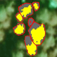
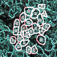
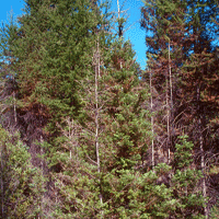
Orthophoto maps based on color-infrared aerial photography have been used by the Lithuanian forest inventory since 2001. This study aimed to investigate the opportunities for using these orthophoto maps to predict tree crown defoliation at the single tree and sample plot levels. The test area was located in the Aukstaitija National Park, eastern Lithuania, and it was photographed in the summer of 2008 using a Vexcel UltraCam D digital frame aerial camera to produce digital orthophoto maps with a 0.5 x 0.5 m ground sampling density. Some 1721 tree crowns (mainly pine, spruce and birch), located in 166 permanent sample plots, were identified and delineated on the orthophoto maps. Crown defoliation and other dendrometric characteristics were field-estimated for all of these trees in summer 2008. Judgments on the suitability of using color-infrared aerial photography based orthophotos to estimate tree crown defoliation were based on the accuracy of the defoliation prediction. Defoliation for each crown was predicted using the non-parametric k-Nearest Neighbor (k-NN) method and characteristics extracted from the digital orthophoto maps as the auxiliary variables for prediction. Prediction accuracies were validated using the “Leave One Out” technique by comparing the predicted data with data from field-assessed crown defoliations. The lowest root mean square errors for the predicted tree crown defoliation values were 7.564 for pine trees, 9.166 for spruce and 7.712 for birch and the highest coefficients of correlation between field-estimated and predicted crown defoliations were 0.576, 0.600 and 0.386, respectively. However, there was no best performing solution for using the k-NN prediction found, as the best results were achieved using different approaches. Next, predicted and field estimated tree crown defoliation values were aggregated up to the sample plot level by taking an averaging of trees in the same sample plot. The root mean square error at the sample plot level was around 3.7 %, the bias was statistically not significant and the correlation coefficients between plot-wise average values of field-estimated and predicted defoliations were around 0.8. The achieved results suggested that color-infrared orthophoto maps could be a potential data source of forest health characteristics for use in stand-wise forest inventories.
Keywords
Color-infrared Aerial Image, Orthophoto Map, Non-parametric k-Nearest Neighbor Method, Tree Crown Defoliation
Authors’ Info
Authors’ address
Laboratory of Geomatics, Institute of Land Management and Geomatics, Aleksandras Stulginskis University, Studentu 11, LT-53361 Akademija, Kaunas distr. (Lithuania)
Laboratory of Forest Monitoring, Institute of Forest Management and Wood Science, Aleksandras Stulginskis University, Studentu 11, LT-53361 Akademija, Kaunas distr. (Lithuania)
Institute Forest Management and Wood Science, Aleksandras Stulginskis University, Studentu 11, LT-53361 Akademija, Kaunas distr. (Lithuania)
Corresponding author
Paper Info
Citation
Eigirdas M, Augustaitis A, Mozgeris G (2013). Predicting tree crown defoliation using color-infrared orthophoto maps. iForest 6: 23-29. - doi: 10.3832/ifor0721-006
Academic Editor
Alberto Santini
Paper history
Received: Jul 31, 2012
Accepted: Nov 19, 2012
First online: Jan 14, 2013
Publication Date: Feb 05, 2013
Publication Time: 1.87 months
Copyright Information
© SISEF - The Italian Society of Silviculture and Forest Ecology 2013
Open Access
This article is distributed under the terms of the Creative Commons Attribution-Non Commercial 4.0 International (https://creativecommons.org/licenses/by-nc/4.0/), which permits unrestricted use, distribution, and reproduction in any medium, provided you give appropriate credit to the original author(s) and the source, provide a link to the Creative Commons license, and indicate if changes were made.

Web Metrics
Breakdown by View Type
Article Usage
Total Article Views: 57869
(from publication date up to now)
Breakdown by View Type
HTML Page Views: 48199
Abstract Page Views: 3520
PDF Downloads: 4524
Citation/Reference Downloads: 20
XML Downloads: 1606
Web Metrics
Days since publication: 4946
Overall contacts: 57869
Avg. contacts per week: 81.90
Citation Metrics
Article Citations
Article citations are based on data periodically collected from the Clarivate Web of Science web site
(last update: Jul 2026)
Total number of cites (since 2013): 6
Average cites per year: 0.43
Publication Metrics
by Dimensions ©
Articles citing this article
List of the papers citing this article based on CrossRef Cited-by.
References
Cartographical modeling of tree crown defoliation. Silviculture, Transactions of Lithuanian Forest Institute and Lithuanian University of Agriculture 1 (53): 75-87. [in Lithuanian].
Gscholar
Color infrared aerial images to evaluate tree crown defoliation. In: Proceedings of the 4 International Scientific Conference “Rural development 2009”. Akademija, Lithuanian University of Agriculture (Lithuania) 15-17 October, 2009, vol. 4, book 2, pp. 213-216.
Gscholar
Integration of LiDAR and digital aerial imagery for detailed estimates of Lodgepole Pine (Pinus contorta) volume killed by Mountain Pine Beetle (Dendroctonus ponderosae). Journal of Forestry 108 (3): 111-119.
Gscholar
Remote sensing and GIS in Lithuanian forestry. In: Proceedings of the IUFRO Conference “Remote sensing and Forest Monitoring” (Zawila-Niedzwiecki T, Brach M eds). Rogow (Poland) 1-3 June 1999, pp. 124-132.
Gscholar
GIS and remote sensing in Lithuanian forest inventory system. In: Proceeding of III International Symposium “Application of Remote Sensing in Forestry” (Zihlavnik S, Scheer L eds). Faculty of Forestry, Technical University in Zvolen (Slovakia) 22-24 Sep 1993, pp. 35-40.
Gscholar
Users guide to the most similar neighbor imputation program. Version 2. Gen. Tech. Rep. RMRS-GTR-96, Rocky Mountain Research Station, USDA Forest Service, Ogden, Utah, USA, pp. 35.
Gscholar
Investigations of interpretation criteria of defoliated pine stands. Silviculture 42: 21-23. [in Lithuanian]
Gscholar
The usage of digital images for forest inventory. Silviculture 42 (2): 5-11. [in Lithuanian].
Gscholar
Aerial photography. Encyclopedia, Vilnius, Lithuania, pp. 248. [in Lithuanian]
Gscholar
Research of the informativeness of the digital images. Agricultural sciences 3: 95-102. [in Lithuanian]
Gscholar
Potential and limitation of visual indices of tree condition. Chemosphere 4-5: 1031-1036.
Gscholar
Central European contribution to remote sensing and photogammetry in forestry. In: Proceedings of the “IUFRO centennial meeting in Berlin”. Berlin (Germany) 31 Aug - 4 Sep 1992. Japan Society for Forest Planning Press, Faculty of Agriculture “Forest resource inventory and monitoring and remote sensing technology”, Tokyo University of Agriculture and Technology, Saiwaicho, Fucku, Tokyo, Japan, pp. 196-212.
Gscholar
Detecting pine sawfly defoliation by means of remote sensing and GIS. Forstschutz Aktuell 44: 14-15.
Gscholar
Interpretation criteria of orthophotos, used in forest inventory. Transactions of Lithuanian Forest Institute and Lithuanian University of Agriculture. Silviculture 1 (55): 49-59. [in Lithuanian].
Gscholar
Geographic information systems in forest inventory in Lithuania - a decade of practical application. Sylwan 1: 58-63. [in Polish]
Gscholar
Aerial photography of Lithuanian forests: challenges and prospects for tomorrow. In: Proceedings of conference “Surveying engineering and GIS”, January 2010. Department of Geodesy, Faculty of Landscape management, Kaunas College, Mastaičiai, Lithuania, pp. 49-54. [in Lithuanian with English summary]
Gscholar
Small format aerial images to estimate the pine crown defoliation. In: Proceedings of the “5 International Scientific Conference on Rural Development”. Akademija, Aleksandras Stulginskis University, 24-25 November 2011. vol. 5, book 2, pp. 452-458.
Gscholar
Estimation of forest variables using satellite image data and airborne LiDAR. PhD thesis, Swedish University of Agricultural Sciences, The Department of Forest Resource Management and Geomatics. Acta Universitatis Agriculturae Sueciae. Silvestrias 17.
Gscholar
Lithuanian forest condition and its influencing factors. Lutute Publishing, Kaunas, Lithuania, pp. 90. [in Lithuanian]
Gscholar
Multi-source national forest inventory of Finland. In: Proceedings of the “IUFRO S4.02 Ilvessalo Symposium on National Forest Inventories”. Finnish Forest Research Institute, University of Helsinki, Finland, pp. 52-60.
Gscholar
The Finnish multisource national forest inventory - small area estimation and map production. Chapter 12. In: “Forest inventory: methodology and applications” (Kangas A, Maltamo M eds). Springer, Berlin, Germany, pp. 191-220.
Gscholar
Manual on methods and criteria for harmonized sampling, assessment, monitoring and analysis of the effects of air pollution on forests. ICP, pp. 178.
Gscholar
The use of GIS and remote sensing for forest monitoring in Poland. In: “Remote sensing and computer technology for natural resource assessment - vol. II” (Saramaki J, Koch B, Lund G eds). Proceedings of the Subject Group S4.02-00 “Forest Resource Inventory and Monitoring” and Subject Group S4.12-00 “Remote Sensing Technology”. IUFRO XX World Congress, Tampere (Finland) 6-12 August 1995. The University of Joensuu, Faculty of Forestry, Research Notes 48: 29-42.
Gscholar
Related Content
Mozgeris G, Augustaitis A
Vol. 6, pp. 15-22 (online: Feb 2013)
Johnson J, Jacob M
Vol. 3, pp. 86-88 (online: Jul 2010)
Bussotti F, Papitto G, Di Martino D, Cocciufa C, Cindolo C, Cenni E, Bettini D, Iacopetti G, Ghelardini L, Moricca S, Panzavolta T, Bracalini M, Pollastrini M
Vol. 17, pp. 300-308 (online: Oct 2024)
Tolunay D, Karabiyik B, Temerit A
Vol. 4, pp. 145-149 (online: Jun 2011)
Danusevičius D, Marozas V, Augustaitis A, Plaušyte E
Vol. 6, pp. 262-267 (online: Oct 2013)

Badea O, Neagu S, Bytnerowicz A, Silaghi D, Barbu I, Iacoban C, Popescu F, Andrei M, Preda E, Iacob C, Dumitru I, Iuncu H, Vezeanu C, Huber V
Vol. 4, pp. 49-60 (online: Apr 2011)
Popa I, Badea O, Silaghi D
Vol. 10, pp. 554-560 (online: Jun 2017)
Jonikavičius D, Mozgeris G
Vol. 6, pp. 150-155 (online: Jun 2013)

Chen X, Bowman KA
Vol. 15, pp. 315-321 (online: Aug 2022)
Aydin Coskun A, Türker OY, Velioglu N
Vol. 4, pp. 181-185 (online: Aug 2011)


