Public participation GIS to support a bottom-up approach in forest landscape planning
iForest - Biogeosciences and Forestry, Volume 6, Issue 6, Pages 347-352 (2013)
doi: https://doi.org/10.3832/ifor0917-006
Published: Aug 29, 2013 - Copyright © 2013 SISEF
Research Articles
Abstract
Forest landscape planning analyses all forest aspects (economic, ecological and social) and defines long-term forest management guidelines. Various actors are involved in landscape planning; therefore the analysis needs to take into account goals and targets of the different stakeholders. The participatory process can strongly support the development of a bottom-up forest plan definition when stakeholders are involved throughout the decision-making process. In this way, management guidelines are defined by decision makers and local communities through a shared process. With this approach, Public Participation GIS (PPGIS) is a useful tool to support the decision-making process in forest planning. The aim of the paper is to present a method that matches these requirements by exploiting the potential of GIS. The application of Public Participation GIS (PPGIS) is a useful support to integrate stakeholders’ priorities and expectations into forest planning strategies. Furthermore, it represents the starting point to draw up management scenarios by integrating and comparing both technical and social priorities. This paper presents an application of PPGIS in a forest landscape plan in southern Italy (Alto Agri district, Basilicata region).
Keywords
Forest Landscape Planning, Public Participation, Decision Making, Public Participation GIS
Introduction
Forest landscape planning is a management approach that takes into account all forest functions in an integrated and holistic way ([10]). This approach is intended to have an intermediate role (tactical level) between forest management plans at a national or regional level and at forest management unit level ([1]). Forest landscape planning addresses long-term forest management guidelines, based on three key issues: (i) a particular emphasis on Sustainable Forest Management (SFM) as a management paradigm; (ii) a large-scale analysis (landscape) and a small-scale intervention; (iii) a special attention to the involvement of stakeholders in the decision-making process ([2]).
SFM is the forest management paradigm born in the early ’90s in the wake of the principles established by the United Nations Conference on Environment and Development (Rio de Janeiro 1992). SFM involves the balancing of ecological, social and economic values to meet society’s objectives over the long term ([16]), with the key objective of maintaining health, integrity, and biodiversity of forest ecosystems of various sizes ([12]).
Large-scale analysis and small-scale intervention are the challenge of forest landscape planning: the extensive analysis of the forest as an ecosystem is therefore coupled with the definition of specific planning interventions. In order to manage specific forest types, the evaluation of complex and various parameters that can describe the overall multifunctionality, is developed in parallel with the accurate definition of planning and silvicultural options.
Social, as well as environmental, sustainability, plays a key role in forest landscape planning. This kind of sustainability requires that individual or groups of actors affected by a plan or program in any way have the right to be involved in the planning process ([11]). In general, participation covers processes and mechanisms that enable people having a direct stake in forest resources to be part of decision-making in various aspects of forest management ([7]). Participatory planning can be characterized by different phases and levels of public involvement ([9], [5]), but the participatory process can add concrete support for the development of a bottom-up forest plan when stakeholders are involved throughout the decision-making process. In this way, management guidelines are jointly defined by decision makers and local communities ([2]).
In view of these issues, a method which supports landscape planning should be developed in order to: (i) gather the different information collected during the field survey and the participation process; (ii) organize the preferences of the stakeholders and communicate to them all the information concerning the various planning alternatives; (iii) provide transparency and traceability to the decision-making process.
The aim of the paper is to present a method that matches these requirements by exploiting the potential of GIS. The application of Public Participation GIS (PPGIS) is a useful support to integrate stakeholders’ priorities and expectations into forest planning strategies. Furthermore, it represents the starting point to draw up management scenarios by integrating and comparing both technical and social preferences.
Materials and methods
Study area
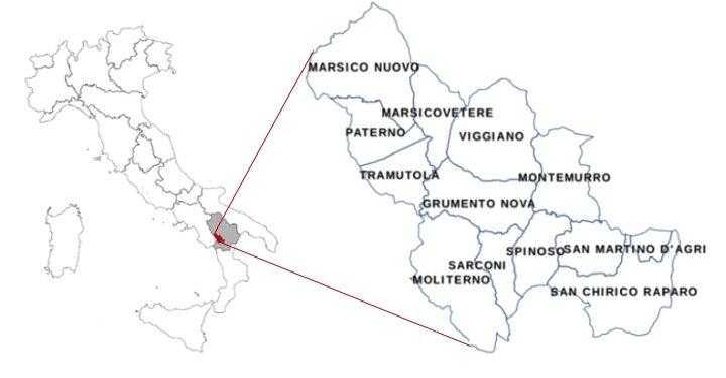
The Alto Agri district, located in the Basilicata region, southern Italy (40° 20’ 25” N; 15° 53’ 52” E), occupies about 72 559 hectares and includes twelve municipalities (Fig. 1). Geographically, the territory is characterized by a main valley, through which the Agri river flows. With a population of 33 739 inhabitants, the current density is 60 people km-2, well below the national average of 200.1 people km-2. This is the result of a slow depopulation, which started in the 1950s and has continued to this day. The forest area covers 42 367 hectares (58.4% of the district). Privately-owned land amounts to 72.8%, whereas the remaining 27.2% is owned by public authorities, i.e., various municipalities and the Basilicata Region.
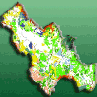
Fig. 1 - The Alto Agri district.
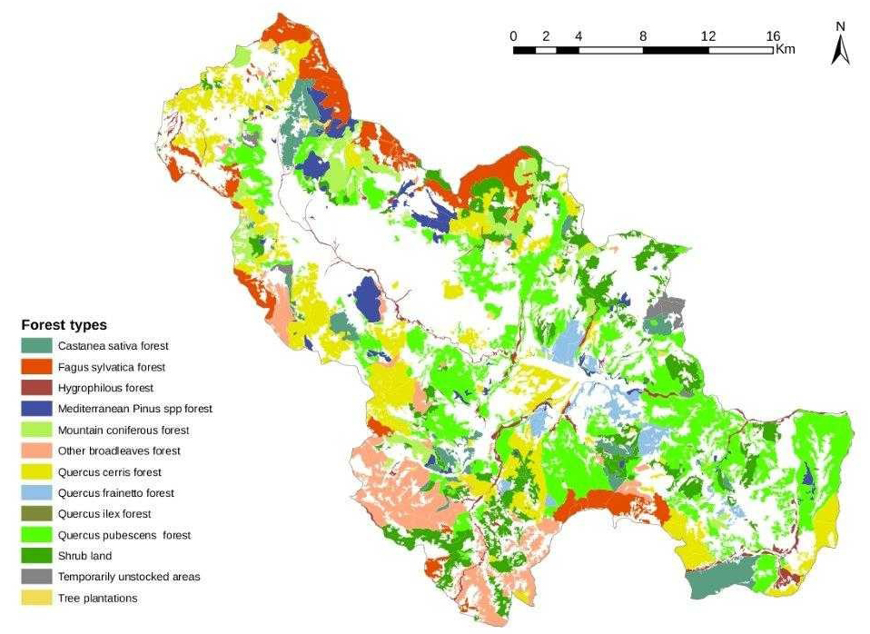
The three main forest types (Fig. 2) are the Quercus pubescens Willd. forests (28%), the Quercus cerris L. forests (18%) and the Fagus sylvatica L. forests (10%). Collectively, the other forest types constitute about 30%, with large differences in types and species composition. In addition, shrubland covers 13% of the territory.
Fig. 2 - Forest types in the Alto Agri district.
About 47 567 ha, 66% of the study area, are located in protected areas, 37 188 hectares are included in the Appennino lucano-Val d’Agri - Lagonegrese National Park (about 51% of the study area) and 33 648 ha (about 46%) in the Natura 2000 sites. Natura 2000 sites and park areas partially overlap.
The forest landscape plan of the Alto Agri district is one of the first experimental plans in which special attention was paid to the development of a particular participatory approach ([2], [4]). The participatory process used in the district took place concomitantly with the formulation of the plan. This process was based fundamentally on consultation, a method whereby stakeholders are informed about planning proposals and then heard about their expectations. In addition, whenever an input arising from the consultation is included in the decision process, a feedback to the stakeholders is provided ([9]). In the present method, consultation has also the important function of receiving useful input from stakeholders for the definition of the objectives of the plan.
Research design
In order to achieve the goal of comparing stakeholders’ preferences with technical assessments, the research was divided into three phases: (i) evaluation of forest functions and multifunctionality from the technical point of view; (ii) a survey of stakeholders’ individual preferences in relation to forest functions; (iii) development of a Public Participation GIS to support small-scale forest planning.
Forest inventory phase and technical evaluation of forest multifunctionality
At the beginning of the landscape planning process, technical managers and decision-makers held a brainstorming to discuss the various issues concerning the development of the plan. On this occasion, they outlined the main functions of the Alto Agri forests, gathering and comparing information already available, such as cartography, previous management plans, etc. The following functions were identified: firewood production, timber production, non-wood forest products (NWFP) collection, hydro-geological protection, tourist and recreational activities, landscape conservation and habitat conservation.
During the forest inventory phase, forest functions are assessed both in ecological and technical terms in 577 sampling areas, each of 5 000 m2, stratified by forest type. In each sampling point both qualitative attributes of the forest (descriptive investigation) and quantitative data (measurable parameters) were collected. Description was focused on site data collection as well as on the survey of standing structures, i.e., trees, shrubs and herbaceous layers. Over and above the statistical parameters, the inventory goal was to define forest functions for each sub-category to evaluate overall multifunctionality.
At each sampling point, this was evaluated by estimating the capacity of the forest to fulfill different functions in the context of an Index of Importance of Function (I). The estimation was made by providing a score for each function and considering both measured structural parameters and qualitative assessment performed by technicians. A scale ranging from 0 to 10 was used to synthesize the assessment. A value of 10 was assigned to the prevailing function, while decreasing values (9, 8, 7 etc.) were assigned to other functions of decreasing importance. A score of 0 (zero) was attributed to functions not provided by forests in the specific context ([3], [13]).
Functions reported in literature had to be adapted to the Alto Agri context. The sampling points were aggregated per municipality and then compared using two indicators measuring the level of multifunctionality. The two indicators were made as follows: (1) average value of each function associated with the municipality vfft (eqn. 1):
where n is the total of sampling points per municipality and Ii is the index of Importance of Function at sampling point i. (2) mean total value of all functions VF FT referred to each municipality (eqn. 2):
where m is the total of functions and vfft j the average value of a municipality for function j.
Moreover, the total value and the value of each function were calculated for the entire area of the Alto Agri district and for the individual forest types.
Stakeholders’ preferences
Through a preliminary stakeholder analysis, a total of 115 actors were identified. A distinction was made among the stakeholders, between institutional (public administration) and non-institutional actors: of them, 32 belonged to the first category and 83 to the second. In the latter non-institutional category, 23 actors belonged to the non-profit world (18 environmental and local associations, 5 hunting associations). The remaining share included individual actors representative of the following activities: 20 tourism farmers and other actors linked to tourism, 25 actors of the forestry-timber chain (forest owners, forest and wood entrepreneurs) and 15 cattle-breeding entrepreneurs.
During the first stage of consultation, a questionnaire was chosen as the tool to gather stakeholder preferences regarding forest functions. The questionnaire - subdivided into thematic sections (one thematic section specifically concerned forest multifunctionality) - was completed by interviewers during face-to-face interviews.
The list of forest functions identified during the brainstorming phase was presented to the interviewees. Individuals were allowed to integrate the list with more forest functions and asked to assess the importance of each forest function in a 4-rank scale (4: high; 3: medium; 2: low; 1; very low importance).
Furthermore, interviewees were requested to specify which area their answers referred to, with three possibilities: (1) one municipality; (2) two or more municipalities; and (3) the entire district. The request to declare the reference area was aimed at georeferencing the collected information.
Eventually, the individual preferences attributed by the stakeholders to each forest function were elaborated, sorting them according to a list of priorities. The results were subsequently converted into a 10-rank scale and compared with those reached by forestry experts in the field. According to the list, and to gaps between functions, it was then possible to get a clear overview of stakeholders’ priorities and expectations. The information was successively assessed on the basis of both (i) the forest survey, and (ii) its technical feasibility, in order to support managers in the definition of preliminary management strategies ([14]).
Public Participation GIS
GIS linked to the participatory approach in the decision making can be defined as Public Participation GIS (PPGIS). More specifically, in forest decision making and participatory planning, GIS provides an opportunity to determine the geographic location of opinions ([8]), to couple and compare social preferences with technical evaluations (forest measurements) in a spatially determined area.
In the case study, the information flow chart of PPGIS can be represented in various steps (Fig. 3).
Fig. 3 - Steps and relationships of qualitative, spatial and preference analysis in the Public Participatory GIS.
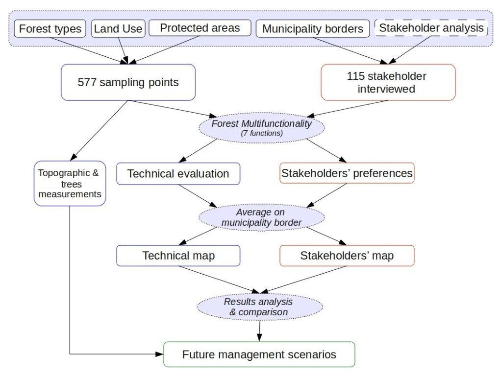
First, all available information on the geographical maps (forest types, land use, protected areas and municipality borders) and the results of the stakeholder analysis (location and category of each stakeholder) were collected and processed to characterize the study area.
Secondly, the information collected in the field (sampling points) and the results of stakeholders’ questionnaires were used for the evaluation of forest multifunctionality. For each sampling point, all forest functions were evaluated and georeferred to the relative geographic point, while for each stakeholder the same information was evaluated and georeferred to the municipality concerned.
Thirdly, in order to compare the evaluation of technicians and stakeholders, the values of the sampling points were averaged for each municipality. Both technical and stakeholders’ maps were obtained in this way.
Eventually, the two evaluations were compared in order to analyze differences and similarities. This comparison was basically a graphical representation of technical and social priorities and the proper way to gather and organize information to be shown in a simple way to planners and political decision makers. This analysis could be the starting point for building up future management scenarios by integrating and comparing both technical and social preferences.
Results and discussion
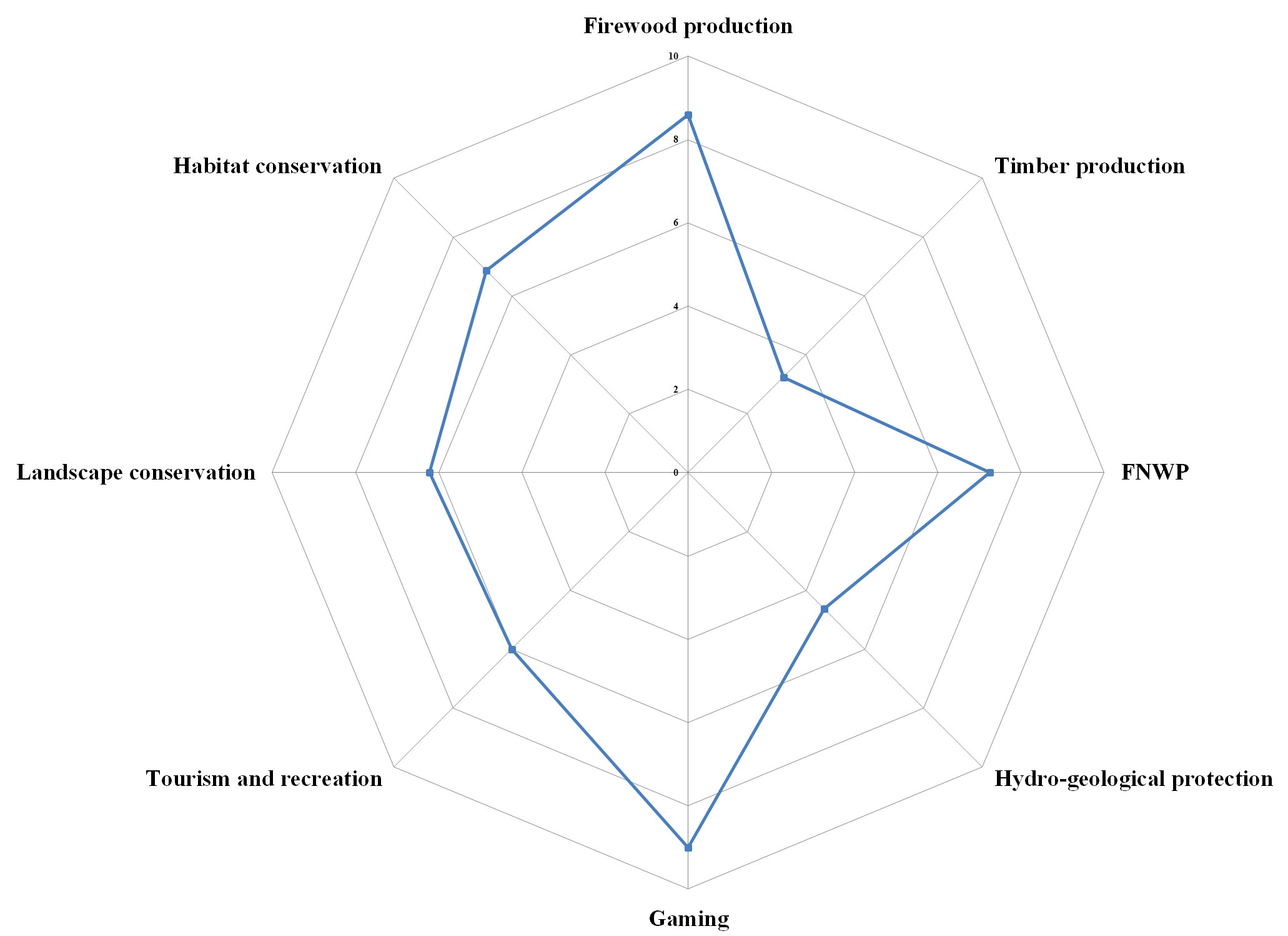
The results of technical and stakeholders’ evaluations for each forest function are represented and compared in Fig. 4 and Fig. 5.
Fig. 4 - Mean values of forest functions values as for the technical evaluation.
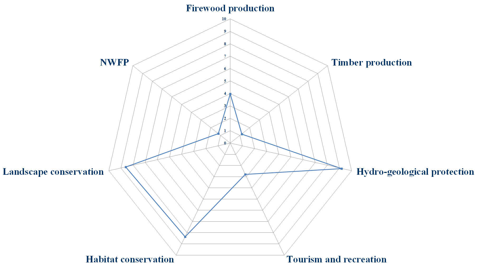
Fig. 5 - Mean values of forest functions values as for the stakeholder evaluation.
The chart of technical evaluation highlights three main forest functions which dominate the others, i.e., hydrogeological protection (9.2), landscape conservation (8.6) and habitat conservation (8.4).
This result is mainly influenced by the forest type; currently firewood production is high in Quercus pubescens Willd. forests (8.1), Quercus cerris L. forests (8.3) and Quercus frainetto Ten. forests (8.2) and relatively low in all the other forest types. Timber production shows low values only in chestnut (3.9) and beech forests (4.0), while habitat conservation reaches its maximum in Quercus ilex L. forests (9.7).
The results of stakeholders’ preferences show that the most important forest function is gaming (mean value 8.6), a function which was not on the list at the brainstorming phase. The other functions that were considered important by the stakeholders are: firewood production (8.5), NWFP collection (6.9) and habitat conservation (6.4).
The results - divided into the five categories of stakeholders with similar interests and purposes - are reported in Tab. 1. The public administration, compared to other actors, gives higher scores to those functions of possible benefit to the community (hydrogeological protection, landscape and habitat conservation). An anomalous result is observed for local and environmental associations giving higher values to gaming (8.9) and timber production (4.1) in comparison to other social actors. It is likely that these results show that the same forest function is not perceived in the same way by everybody. Vice versa, the stakeholders indicate gaming as a crucial function, although initially this variable had not been considered by technicians and decision makers.
Tab. 1 - Perceptions of forest functions per stakeholder category.
| Parameters | Firewood | Timber | NWFP | Hydro-geological protection | Tourismactivities | Landscape conservation | Habitat conservation | Gaming |
|---|---|---|---|---|---|---|---|---|
| Public administration | 8.9 | 3 | 7.3 | 5.3 | 5.9 | 6.5 | 7.7 | 8.8 |
| Cattle-breeding actors | 8.3 | 2.2 | 6.8 | 4.7 | 6 | 5.7 | 7.1 | 8.2 |
| Forest-wood chain actors | 8.1 | 3.6 | 6.6 | 4.5 | 5.3 | 5.5 | 6.1 | 8.5 |
| Local associations | 8.7 | 4.1 | 7 | 3.5 | 6.1 | 5.4 | 5.6 | 8.9 |
| Tourism actors | 8.3 | 3.2 | 7 | 3.2 | 6.7 | 4.7 | 5.3 | 8.3 |
| Mean | 8.5 | 3.2 | 6.9 | 4.2 | 6 | 5.5 | 6.4 | 8.6 |
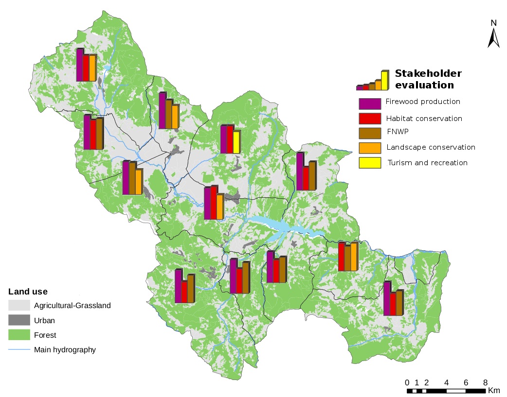
Two maps drawn by the PPGIS show three main functions in each municipality in both technical and stakeholders’ evaluation (Fig. 6 and Fig. 7). The gaming function is not considered here, in order to compare the same functions.
Fig. 6 - Comparison between main forest functions in the technical evaluation map.
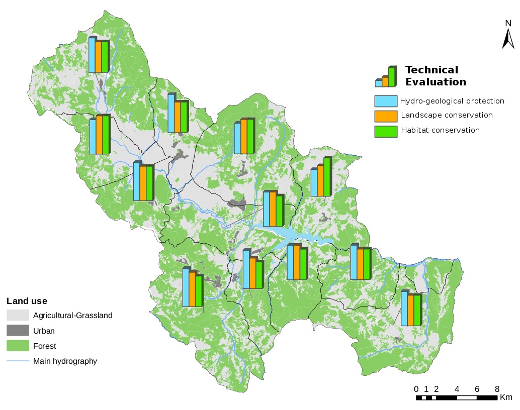
Fig. 7 - Comparison between main forest functions in the stakeholders’ evaluation map.
The first map shows how technicians evaluated the same three functions as the most important in all municipalities: the Alto Agri district forests are valued mainly as watersheds and for soil protection. Differences among municipalities are found in the priority list: soil and natural risk protection were ranked as the first function in nine municipalities, habitat conservation in two municipalities and landscape conservation in one municipality.
Five main functions are found in the second map: in almost all municipalities firewood is rated higher then habitat conservation, NWFP and landscape conservation being the other functions of considerable importance. Only in one municipality (Viggiano) is the tourism and recreation function present (third position, 8.1).
In southern and eastern municipalities (Moliterno, Sarconi, San Chirico in Raparo, Montemurro) the values of the functions are very similar, being firewood production, forest non-wood products (NWFP) and habitat conservation respectively. Moreover, forest productive functions show a high rating, especially in the municipalities of Montemurro (firewood production: 10, timber production: 4.8) and Paterno (firewood production: 9.17, timber production: 4.8), while the stakeholders of Tramutola attribute a high value to firewood production (8.9) and NWFP (8.6). Grumento Nova scores the highest value for habitat conservation (8.9), and San Martino d’Agri for landscape and habitat conservation (7.5).
The evaluations of technicians and stakeholders are quite different: technicians seem to emphasize the role of environmental functions (landscape and habitat conservation), whereas stakeholders attribute great importance to productive functions (firewood).
The differences are probably due to various factors:
- technical evaluations take into consideration the presence of the Appennino lucano-Val d’Agri-Lagonegrese National Park and of the Natura 2000 sites. Stakeholders do not appear to consider this, possibly because these protected areas were only recently created.
- technical estimation of productive function values are based, as far as possible, on objective parameters. This evaluation guarantees an objective comparison of different areas, but does not take account of the economic role of forests for local communities;
- Viggiano is the Alto Agri municipality where both religious and winter tourism has its greatest impact. The attention paid by the local stakeholders to tourism and recreational functions is probably attributable to these characteristics;
- according to the technical evaluation, less importance is given to the hydrogeological function in Montemurro municipality. This is probably due to the scarcity of coniferous and holm oak forests in the region, i.e., forest types which give the highest values to hydrogeological function.
During the implementation of the forest landscape plan, the differences between the evaluations of stakeholders and technicians must be taken into account. Since a participatory process has been adopted, the power relationships among the actors involved must be clearly defined as well as the roles of the different stakeholders in the decision-making process.
In this case, considering that a consultation process has been established and the priorities of the stakeholders have to be considered, during the implementation of the plan it is necessary to decide proactively which productive functions (firewood or biomass-energy production) should be improved and which forest areas should be enhanced. This stage of the consultation process should be performed by creating specific focus groups set up by an external facilitator. At the end of these meetings, stakeholders and technicians have to reach a satisfactory compromise.
The present experience of public participation with GIS support can be considered an interesting approach to integrate the spatial preferences of stakeholders in forest landscape planning. The preferences of the stakeholders can be included in the forest planning through the formulation of a management hypothesis designed to satisfy the needs of local communities. In particular, two or more scenarios of forest planning, in which are included the preferences expressed by the stakeholders, are prepared by technicians. Successively, these are presented to the stakeholders during a focus group. Each scenario is characterized by different objectives and strategies and supported by maps. The scenarios will then be discussed and re-elaborated through an interactive decision-making process. This process will eventually lead to the definition of a shared scenario (forest landscape plan), with a real and transparent input from stakeholders. In this way social sustainability is increased without compromising ecological sustainability.
Conclusions
In a field survey, technicians build up their evaluation scores accounting for both site conditions and qualitative/structural parameters of forests. The estimation is based on objective remarks and takes into account the current differences between areas. On the other hand, stakeholders’ evaluations are based on their individual perception and less attention is paid to the technical features of forests. Therefore, the evaluations can be greatly influenced by the emotional and imaginary sphere and may lack an objective estimation. On this basis, a participatory process which evolves throughout the forest planning allows the better incorporation of priorities and expectations from all the actors and takes their opinions into account in the draft plan ([15]). The comparison and integration of technical and social evaluations of forest functions can be the starting point for the development of future management scenarios, based on a shared multifunctionality evaluation ([4]).
PPGIS proved to be a useful support to facilitate the gathering and organizing of stakeholders’ preferences, as well as an interesting tool to compare the evaluations of both technicians and stakeholders.
In the field of participatory planning, this step provides the stakeholders the chance to verify their real ability in defining planning alternatives. In general it means giving transparency and traceability to the decision-making process and demonstrating that participation can really influence the definition of planning strategies.
The territory of the Alto Agri district, especially the privately-owned areas, is currently managed in a mono-functional way, i.e., for firewood production. The priority of forest functions expressed by the stakeholders confirms this requirement. Similarly, technical evaluations support the value of addressing a multifunctional goal in the management of Alto Agri forests.
A re-adaptation of the Wake Theory or Kielwassertheorie may respond to this requirement. Its original formulation postulates that social forest outputs result from profit-oriented forest management. In other words, the primary goal to be pursued is to produce firewood and timber. The remaining forest functions follow “in the wake” of this main function, without any specific management intervention ([6]). This theory was conceived in the mid 20th century in Germany and was valid in a specific social and cultural context. Its application today requires some conceptual re-adjustments. A possible application may be the direct achievement of multifunctionality by two to three functions and the indirect fulfillment of the remaining functions thanks to the “wake effect”.
Acknowledgments
This research was supported by National Institute of Agricultural Economics Research (INEA) - Basilicata Headquarters. The authors have contributed to the study and to writing the paper on an equal basis.
References
Gscholar
Authors’ Info
Authors’ Affiliation
Consiglio per la Ricerca e la Sperimentazione in Agricoltura - Agrobiology and Pedology Centre (CRA ABP), p.za D’Azeglio 30, I-50121 Florence (Italy)
Consiglio per la Ricerca e la Sperimentazione in Agricoltura - Apennine Forestry Research Unit (CRA-SFA), v. Bellini 8, I-86170 Isernia (Italy)
Perugia (Italy)
Alessandro Paletto
Consiglio per la Ricerca e la Sperimentazione in Agricoltura - Forest Monitoring and Planning Research Unit (CRA-MPF), p.za Nicolini 6, I-38100 Villazzano, Trento (Italy)
Corresponding author
Paper Info
Citation
De Meo I, Ferretti F, Frattegiani M, Lora C, Paletto A (2013). Public participation GIS to support a bottom-up approach in forest landscape planning. iForest 6: 347-352. - doi: 10.3832/ifor0917-006
Academic Editor
Luca Salvati
Paper history
Received: Nov 23, 2012
Accepted: May 04, 2013
First online: Aug 29, 2013
Publication Date: Dec 02, 2013
Publication Time: 3.90 months
Copyright Information
© SISEF - The Italian Society of Silviculture and Forest Ecology 2013
Open Access
This article is distributed under the terms of the Creative Commons Attribution-Non Commercial 4.0 International (https://creativecommons.org/licenses/by-nc/4.0/), which permits unrestricted use, distribution, and reproduction in any medium, provided you give appropriate credit to the original author(s) and the source, provide a link to the Creative Commons license, and indicate if changes were made.

Web Metrics
Breakdown by View Type
Article Usage
Total Article Views: 57758
(from publication date up to now)
Breakdown by View Type
HTML Page Views: 47683
Abstract Page Views: 3816
PDF Downloads: 4539
Citation/Reference Downloads: 39
XML Downloads: 1681
Web Metrics
Days since publication: 4685
Overall contacts: 57758
Avg. contacts per week: 86.30
Article Citations
Article citations are based on data periodically collected from the Clarivate Web of Science web site
(last update: Mar 2025)
Total number of cites (since 2013): 14
Average cites per year: 1.08
Publication Metrics
by Dimensions ©
Articles citing this article
List of the papers citing this article based on CrossRef Cited-by.
Related Contents
iForest Similar Articles
Review Papers
Public participation: a need of forest planning
vol. 7, pp. 216-226 (online: 27 February 2014)
Technical Advances
Forest planning and public participation: a possible methodological approach
vol. 5, pp. 72-82 (online: 12 April 2012)
Research Articles
Public participation in sustainable forestry: the case of forest planning in Slovakia
vol. 7, pp. 414-422 (online: 19 May 2014)
Editorials
Spatial information and participation in socio-ecological systems: experiences, tools and lessons learned for land-use planning
vol. 7, pp. 349-352 (online: 19 May 2014)
Research Articles
Communicating spatial planning decisions at the landscape and farm level with landscape visualization
vol. 7, pp. 434-442 (online: 19 May 2014)
Research Articles
Public attitudes towards the use of transgenic forest trees: a cross-country pilot survey
vol. 9, pp. 344-353 (online: 20 November 2015)
Research Articles
Does higher owner participation increase conflicts over common land? An analysis of communal forests in Galicia (Spain)
vol. 8, pp. 533-543 (online: 01 December 2014)
Research Articles
Confronting international research topics with stakeholders on multifunctional land use: the case of Inner Mongolia, China
vol. 7, pp. 403-413 (online: 19 May 2014)
Research Articles
The concept of green infrastructure and urban landscape planning: a challenge for urban forestry planning in Belgrade, Serbia
vol. 11, pp. 491-498 (online: 18 July 2018)
Research Articles
Usefulness and perceived usefulness of Decision Support Systems (DSSs) in participatory forest planning: the final users’ point of view
vol. 9, pp. 422-429 (online: 02 January 2016)
iForest Database Search
Search By Author
Search By Keyword
Google Scholar Search
Citing Articles
Search By Author
Search By Keywords
PubMed Search
Search By Author
Search By Keyword


