A WebGIS tool to support forest management at regional and local scale
iForest - Biogeosciences and Forestry, Volume 16, Issue 6, Pages 361-367 (2023)
doi: https://doi.org/10.3832/ifor4445-016
Published: Dec 13, 2023 - Copyright © 2023 SISEF
Technical Advances
Abstract
One of the most important obstacles for taking advantage of forest resources in the Italian Alps is represented by the high level of private properties fragmentation and by their small size. Thus, there is an urgent need for tools to support single or multi-forest owners to gain reliable and updated information on their forest stands so that the proper silvicultural activities following all the existing regulations can be adopted. The present research was aimed at promoting a shared management of small private forest properties in the mountainous area of Friuli Venezia Giulia (NE Italy) through the implementation of a new WebGIS tool to support forest decisions and management at different spatial scales. This new tool was developed updating and merging together different available information sources (e.g., tree species composition, the presence of protected areas, forest roads, etc.) with ad-hoc elaborated layers (e.g., standing volume, annual increment of volume, forest accessibility, etc.), also elaborating a cost analysis related to the different possible harvesting methods. The tool allows queries at the level of either a single or a group of cadastral parcels to obtain data in a format, which can be used for filling in the planning document requested by the regional authorities.
Keywords
Forest Decision Support System, WebGIS, Forestry, Accessibility, Volume Estimation
Introduction
Several definitions of Decision Support System (DSS) have been reported in literature, as well as several examples of applications in the forest sector at different spatial and temporal scales exist ([37], [29]). In a broad sense, a Forest Decision Support Systems (FDSSs) is an essential tool that takes into account the existing environmental, economic, administrative, legal and societal aspects of forest management ([37]). Most of the existing DSSs are softwares designed to support decision-making within an organization and are generally based on (i) a graphical user interface (GUI), (ii) a knowledge management system that stores all the information, and (iii) a problem processing system ([9]). Forestry is a long-established area of DSS and GIS application, and an early adopter of Spatial DSS (SDSS) since 1980s ([34], [18]). Some first FDSSs were mainly aimed at supporting the wood production, while subsequent and more detailed systems have been recently developed with the aim of helping multifunctional forest management, so that to consider all the other ecosystem services ([34], [4]). Most FDSSs consider specific operational aspects related to the management of existing forests or plantations, such as forest management planning (e.g., what, when and where to plant/harvest), estimation of potential tree growth, economic estimates of logged wood, optimization of harvest operations ([34], [7], [37], [29]) . Others have been implemented for specific purposes such as fire management ([36]). Despite the formal definition given by Burstein & Holsapple ([9]), from a technical point of view, different information and communication technologies (ICTs) are involved in the developing of DSS ([34], [7], [37], [29]). In some cases, FDSSs are based on a specific software for individual use only, while, more recently, online applications have made the FDSSs more accessible from an Internet 3.0 perspective ([26]). FDSSs have also been developed at different spatial scales, from regional to a more local one, to answer strategic or locally focused questions, respectively ([37], [29]).
FDSSs have been proven to be fundamental tools to promote an active and sustainable forest management, especially in areas characterized by a high level of fragmentation of the private properties ([40]). In fact, they can be efficiently used to properly describe forest stands and to develop shared management options among different owners ([20]), as well as to program silvicultural/forest operations ([25]) and implement and control local specific forest-wood supply chains ([35]).
Harvest intensities (i.e., percentage of current annual increment that is harvested) are quite different across the European countries with values close to 75-100% in Central and Northern Europe and values lower than 25% in Southern and West Europe ([19]). Forest exploitation is particularly low in Italy where, according to different statistics, around 12 million m3 are annually harvested (33% of current annual increment, on average - [30]) despite the high level of wood demand registered on a national scale. Such a low exploitation intensity is mainly due to the geomorphology, the legal constraints and the low density of forest roads per hectare when compared to nearby countries such as Austria and Slovenia, and to the high level of property fragmentation ([38], [27]). In fact, the 66.4% of the Italian forests are private and, in several cases, the cadastral parcels are smaller than 1 ha ([15]). On a national scale, a recent study ([16]) showed that the properties are very small, with a mean forest area per owners of 8.2 ha, less than what reported in the rest of Europe (average size: 12.7 ha - [14], [23]). An assessment of private properties in the North-Eastern Italian Alps showed that private properties are even smaller, with the 95% of the cadastral parcels within an area less than 1 ha ([2]). Moreover, the type of forest owners has changed over time. While in the past owners lived nearby their properties and had a deep knowledge of the forest and its management and services ([1]), now they are often not residents, difficult to contact and with little or no knowledge on the location of their property and/or silvicultural activities ([16]). Thus, new approaches for a shared forest management need to be developed and adopted on a local scale, ensuring a sustainable management of the resources and a constant economic return for the forest owners ([16]). In this context, the Italian forest strategy recognized the need of encouraging the formation of new communities around forests ([28]). Moreover, digitization is recognized as pivotal to support local forest supply chains and bioeconomy ([13], [41], [5], [35]). Thus, FDSSs can play an important role in contrasting the above-mentioned weakness of Italian forest sectors, since they can give access to easy-to-use information ([16]) that can support local forest value chains ([35]).
In the Friuli Venezia Giulia Region (NE Italy), where 196,351 ha of forest are private ([15]), an EIP-AGRI Operational Group (Shared Private Forest Management in Eastern Alps - Pri.For.Man.) was recently created with the aim of reinforcing the private forest sector through a vertical multi-level integration among forest owners, forest entrepreneurs, services and marketing companies and foresters. This paper aims at presenting the new online WebGIS application - named Pri.For.Man. DSS - which was developed within this Operational Group (OG) and that can be considered as an informative system pivotal for forest planning and programming at two different spatial scales. The specific objectives behind the developed WebGIS tool were: (i) to support small forest owners, public bodies and professionals in identifying suitable areas for wood production and in the preparation of the documents required by the regional authorities; (ii) to provide information on local accessibility, thus to derive exploitable standing volume; (iii) to provide a complete assessment of all the existing constraints (i.e., environmental, legal, economic); (iv) to provide aggregated data at regional and municipal scale through an integrated dashboard for online statistics and to support local policy- and decision-makers.
The present paper, after a technical description of the system, reports some statistical data retrieved using the proposed system at regional scale and underlines the pros and cons related to the local assessment of forest resources.
Materials and methods
General framework and participatory approach in designing the FDSS
The target audience is crucial for the identification of the problems, which can be simplified by a DSS ([34], [39]). Thus, the Pri.For.Man. DSS has been developed involving local technicians, regional officers, forest owners, forest companies and professionals through public meetings and operational tests. Overall, eight meetings were organized, of which two with the regional Forest service and six with the other stakeholders. Following the first focus groups, the needs and the obstacles for an active forest management were identified. The FDSS was implemented and then presented to the stakeholders with physical and online meetings so that to receive their feedbacks for further improvements.
Taking into consideration the suggestions obtained during the focus groups, the Pri. For.Man. DSS was developed using the cadastral parcels as elemental units for data interrogation and extraction. Such a choice is related to the fact that most of the authorization process established by the regional regulations (e.g., harvesting activities, forest management plans) require cadastral information but also to the fact that forest stakeholders usually check forest land information based on cadastral identification codes.
Since the DSS designed in the forestry sector are quite often not available for end users or the large public ([32]), the Pri.For.Man. DSS was designed as a WebGIS tool freely accessible on the web at ⇒ https://www.priformandss.it/. The user’s interface (GUI) allows its use also by an audience with little or no knowledge of GIS and informatics, even directly during field operations with a tablet or a notebook, eventually connected to a GPS. The layers can be kept updated in real time with little work by a GIS/ICT technician.
The implementation area
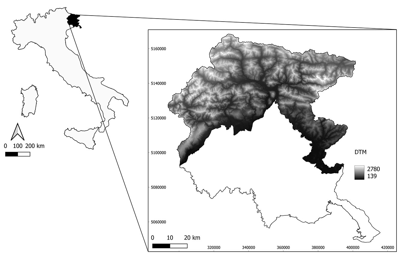
The study area encompasses all the mountains of the Friuli Venezia Giulia region (North-East Italy - Fig. 1) for a total extension of 4,264 km2 (about 40% of the regional surface), out of which 3,271 km2 (77%) are covered by forests and woods.
Fig. 1 - The Friuli Venezia Giulia region is located in the North-East of Italy. The study area, shown as a digital terrain model (DTM), encompasses the hills opened on the plain and heterogeneous mountains reaching about 2780 meters a.s.l. RDN2008 / UTM zone 33N (EPSG 6708).
Spatial layers
The Pri.For.Man. DSS includes 30 different cartographical layers, all freely accessible to the end users (see Tab. S1 in the Supplementary material for the complete list and description). These layers, which the user can easily activate or deactivate in the GUI, are grouped into three main categories: (i) Basic cartographic layers. Among others, they include the cadastral parcels, the topographic map (1:5000), public roads and the recent orthophotos at 20 cm resolution. (ii) Forest management layers. Among others, they include forest categories, the code of forest management plan if existing, the forest roads, the stand accessibility (tractor or cable yard), the actual standing volume, the current annual increment, past harvests and past disturbances (e.g., storms, fires, landslides). (iii) Environmental constrains. Among others, they include the location of biotopes, regional or state parks and reserves, Natura 2000 sites with the specific links to the current management regulations and/or plans, an estimate of the protective role of the vegetation.
Some of these layers were already publicly available, mainly produced and published by the Regional Administration, while some others were created within the OG as described in the following sections. All the layers have been checked for topological errors, and standardized. Except for the production of standing volume and increment maps done with Rstudio (v. 2021.09.1), all the processing was done in QGIS (v. 3.28) and the heaviest dataset, in terms of size, have been managed through a PostgreSQL database, managed with pgAdmin (v. 4.29).
The Pri.For.Man. DSS is a web application running entirely on the web browser and being therefore platform independent. On the backhand, a web server is in charge of handling requests from web clients and providing responses to them, in the form of web pages and downloadable documents (i.e., Microsoft Excel® spreadsheets and maps in JPG format). The backend is made of two main components as depicted in Fig. S1 (Supplementary material): (i) a relational database management system (DBMS) where the data needed by the DSS are stored (PostgreSQL); the DBMS includes a spatial extension enabling the storage and processing of geographical data (PostGIS); (ii) a web server (Apache Tomcat®) that handles the requests (queries) coming from the clients, runs all the calculations needed by the FDSS, and prepares and returns the results to the users. The web server is supported by a second server to allow the sharing of geospatial data (GeoServer - ⇒ https://geoserver.org/).
The frontend is a single-page, responsive application built upon HTML 5, JavaScript and CSS (Cascading Style Sheets), that takes advantage of modern libraries like OpenLayers (to handle spatial data) and frameworks like Bootstrap (to build the graphical user interface - ⇒ https://getbootstrap.com/). The web-app was developed using open-source solutions and uses open standards for communications and data sharing, to ensure ease of maintainability and adequate information sharing standards. The user interface reflects some common approaches previously adopted in many webgis applications: (i) a map area for navigation and zooming; (ii) specific forms for searching localities based on the OpenStreetMap® Nomination tool or the cadastral parcel identification number; (iii) a list of available layers that can be turned on or off and their legends; (iv) the informative part where all the statistics for the selected parcels are summarized; (v) the interface to set the harvest-to-standing volume ratio; (vi) the interface to set the unit costs for the different harvesting operations; (vii) the button to download the Excel® file with all the information organized according to the management document required by the local regulations; (viii) the metadata and a video tutorial tab.
After the selection of the target cadastral parcels, the last tab allows the calculation of extractable volume and the estimation of harvesting costs. The system also embeds a dashboard, developed with Google Looker Studio®, reporting the main data (as volume, accessibility, etc.) at regional and municipal scale.
The standing volume and current annual volume increment maps
To give additional and important information to the final users, a standing volume map (m3 ha-1) and an annual volume increment map (m3 ha-1 y-1) has been developed. These two raster maps have a resolution of 23 m and were realized through the spatialization of the last forest inventory plot-level data using the Random Forest (RF) algorithm ([8]). RF is a decision tree algorithm proved to be the most effective method for the spatial prediction of forest variables using remotely sensed data ([6], [11]). The field reference data for the whole study area referred to 277 plots measured in the framework of the Third Italian National Forest Inventory (INFC) based on a three-phase, non-aligned, systematic sampling design on data surveyed locally between 2018 and 2019 ([15]). For each plot, the standing volume per hectare and the current annual increment per hectare are freely available at ⇒ https://www.inventarioforestale.org/.
Predicting variables for RF training and then regional spatialization are based on Canopy Height Model (CHM) derived from LiDAR data, geomorphological variables (elevation, slope, aspect) and the vegetation indices NDVI, NDII, GNDVI, EVI calculated from a composite cloud free Sentinel-2 images in the months June, July, August for the period 2019-2021. The RF estimates were then validated using the leave-one-out (LOO) procedure obtaining for the standing volume R2 = 0.67, RMSE% = 41% and for current annual increment R2 = 0.47, RMSE% = 57% (Cadez et al., in preparation). These elaborations were performed using the randomForest package in R ver. 4.0.0 ([21]).
Forest accessibility map
A regional forest accessibility map was developed according to the method of the real distance buffer criterion ([31]) using GIS tools, for the two most used harvest systems in the region (i.e., tractor/harvester and cable yard). Such an approach computes the accessible forest area starting from a forest road segment considering the distance that can be reached by the chosen harvest system, corrected for the slope using a cumulative cost function. The input layers were the road network and the slope derived by the digital terrain model at 10 meters of resolution. Each harvest system has limits related to the maximum operational distances, the maximum slope and the presence of the ridgelines. Thus, the original methodology proposed by Picchio et al. ([31]) has been improved by adopting specific maximum operational distances and slopes (Tab. 1 - [22]) and by considering the ridgelines.
Tab. 1 - Adopted maximum operational distances and slopes for the tractor and for the cable yard.
| Machine | Maximum distance (m) | Maximum slope (%) |
|---|---|---|
| Tractor | 100 | 40 |
| Cable yard | 500 | 80 |
More in details, the steps we followed were (Fig. S2 in Supplemetary material): (i) a slope raster was derived from the 10 m DTM and then reclassified, excluding pixels too steep for each harvest system; this raster was then converted from degrees to cosines (note that in QGIS passing through radians is necessary, so: cos(slope·(π/180)); (ii) a raster called d0 with the same spatial resolution of the DTM was produced with a fixed value of 12.07, a sort of average distance considering the possibility to run across a single pixel both perpendicularly (10.00 m) and in oblique way (14.14 m); (iii) the real distance is obtained by the ratio between d0 and slope; (iv) used the “r.watershed” function in QGIS ([17]) to extract the mountain ridges, and overwrite to the previous raster with the 999 value thus to exclude them from the sequent cost calculation; (v) converted roads and ridge lines to points using QGIS tool “Points” along geometry by setting 1 point every 5 meters; (vi) applied the “r.cost” functions to calculate the maximum distance that can be run across by each machines, setting as starting points the roads and the maximum cumulate cost in function of the harvest system (100 m, or 500 m).
Forest harvesting operations costs and harvest intensity
The quantification of harvesting intensity is another important information to simulate the potential forest exploitation. More than 1600 harvest projects and harvest declarations for the period 2014-2020 were analyzed and the frequency distribution of the harvest ratio has been computed (i.e., the ratio between the harvested and the initial standing volume) by forest category, and the median values of each distribution were taken as reference (Tab. 2).
Tab. 2 - Harvest ratio for the main categories derived from harvest projects (source: Friuli Venezia Giulia Forest Service).
| Category | Harvest ratio % | |
|---|---|---|
| Code | Name | |
| B | Temperate oaks | 70 |
| C | Chestnut | 70 |
| D | Hornbeam and Hophornbeam | 70 |
| E | Maple, linden and ash tree mixed stands | 70 |
| G | Beechpure stands | 28 |
| I | Black pines, Scots pine and Mountain pine mixed stands | 13 |
| L | Norway spruce and beech mixed stands | 24 |
| M | Firpure stands | 19 |
| N | Norway spruce pure stands | 22 |
| O | Larch and stone pine stands | 22 |
| R | Black locust pure stands | 90 |
| S | Reforestation with fir | 13 |
| X | Neocolonizations | 70 |
Specific unit costs for the different harvesting operations (i.e., traditional tree felling with motor chain; mechanical skidding extraction; cable yard extraction; transport; pilling up twigs and branches) were considered pivotal for forest planning. These costs were derived by collecting a sample of 30 harvesting projects and analysing the harvested volumes and the sustained costs in a sub-sample of the above-mentioned harvest projects (Tab. 3).
Tab. 3 - Specific unit costs (mean ± standard error) for the different harvesting operations adopted in the Friuli Venezia Giulia Region (NW Italy).
| Harvesting operation | Units | Unit cost | No. obs. |
|---|---|---|---|
| Traditional felling with motor chain | Euro m -3 | 12.82 ± 1.23 | 25 |
| Mechanical skidding | Euro m -3 | 14.94 ± 1.83 | 21 |
| Cable yard extraction | Euro m -3 | 17.93 ± 1.67 | 19 |
| Transport | Euro m -3 | 4.93 ± 0.57 | 20 |
| Pilling up twigs and branches | Euro ha -1 | 113.94 ± 13.48 | 8 |
Implemented analysis tools
All the queries within the Pri.For.Man. DSS starts with the selection of the target cadastral parcels by the final users. The selection can be made either for one single cadastral parcel using the search form or for several parcels drawing a polygon or by uploading a compressed (zip) shapefile. After the selection, the system directly shows some preliminary statistics about the stands’ features. As far as the latter are concerned, the Pri.For.Man. DSS reports the total number of selected cadastral parcels, mean standing volume (m3 ha-1), total standing volume (m3), current annual increment (m3 ha-1 yr-1), total annual increment (m3 yr-1), the surface (ha) accessible through cable yard, tractor or not accessible at all. Then, the user can manually set a specified harvest ratio (i.e., harvest-to-standing volume ratio - from 0 to 100) for the selected cadastral parcels or can use the default harvest ratios as derived in the previous section. The Pri.For.Man. DSS computes the total exploitable volume and estimates the related operational costs derived from the analysis described in the previous section. Unit costs can eventually be modified by the user. All the information can be downloaded for the selected cadastral parcels in an Excel® file, which is divided into eight different sheets: general information, morphology, forest categories, environmental constraints, forest inventory data, accessibility and extractable volume, harvesting costs, and metadata. All this information is required by the regional offices - pursuant to article 11 of regional law 9/2007 - for private properties smaller than 50 ha, and public ones smaller than 200 ha. Above this threshold, a proper forest management plan must be compiled and approved.
Results and discussion
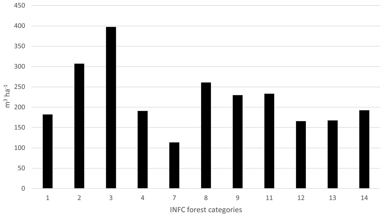
Considering the classification proposed by Segura et al. ([37]), the Pri.For.Man. DSS can be classified as an information system that encompasses DSSs based on Geographic Information Systems and Relational Database Management Systems. In comparison to the existing FDSS, the proposed one works at two different and spatial scales ([29]). At the regional scale, it allows municipalities, mountain communities and/or enterprises to have a clear picture on the available forest resources and the potential exploitation thanks to the specific dashboard that has been integrated into the WebGIS tool. Instead, at a local level it provides detailed information on the forest status using maps that help give a better overview about the local situation ([34]). The retrieved spatial data can support the development of forest policies and strategic planning in the medium- and long-term, as well as energy supply chains, also taking into consideration issues about the conservation and the protection of the soil ([10]). In particular, the aggregated data showed a composite situation at the regional level. The mean standing volume at regional scale is equal to 231 m3 ha-1 on a total forest area of approximately 326,873 ha with significant differences among the forest categories (Fig. 2). The highest and the lowest values have been registered in fir pure stands (397 m3 ha-1) and mountain pine stands (113 m3 ha-1), respectively.
Fig. 2 - Distribution of the mean standing volume (m3 ha-1) forest category. (1): Larch and Stone pine; (2): Norway spruce; (3): Fir; (4): Black pine, Scots pine; (7): Other coniferous forests (mainly Mountain pine); (8): Beech; (9): Temperate oak; (11): Chestnut; (12): Hornbeam and Hophornbeam; (13): Hygrophilous forests; (14): Other deciduous broadleaved forests.
Forest management plans actually cover 48% of the wooded areas of the region, but the production actually occurs on more or less 20% of the forest area as some forest parcels have different functions other than production (e.g., protection, biodiversity, tourism). The 52% of the forest area does not currently have any official management plan. Managed forests have a higher standing volume per hectare than unmanaged ones (230 vs. 187 m3 ha-1), and the difference is even larger when only the forest parcels with a productive function are considered (Tab. 4). Such a strong difference is due to the fact that managed forests are usually on public land and include the most productive forest categories, such as spruce and fir pure stands and beech stands. On the contrary, unmanaged forests are mainly on private lands and comprise mostly mixed broadleaved stands, quite often originated through secondary successions of abandoned agricultural land ([3]).
Tab. 4 - Summary of the total volume and mean volume served and not served in managed/not managed areas in the Friuli Venezia Giulia region (NE Italy).
| Area | Wooded surface (ha) |
Mean standing volume (m3 ha-1) |
Standing volume (m3) |
Surface (%) |
Standing volume (%) |
|---|---|---|---|---|---|
| Managed | 155,456 | 230 | 35,744,207 | 48 | 53 |
| Accessible | 61,815 | 232 | 14,345,747 | 40 | 40 |
| harvester | 13,589 | 205 | 2,791,208 | 9 | 8 |
| Not accessible | 93,641 | 225 | 21,047,774 | 60 | 59 |
| Not managed | 170,140 | 187 | 31,854,479 | 52 | 47 |
| Accessible | 104,346 | 179 | 18,724,208 | 61 | 59 |
| harvester | 25,201 | 152 | 3,841,405 | 15 | 12 |
| Not accessible | 65,794 | 202 | 13,318,579 | 39 | 42 |
| Total | 325,596 | 231 | 67,598,686 | 100 | 100 |
In terms of exploitability, while the 40% of the managed forests (61,815 ha) is accessible through tractor or cable yard, the 61% (104,346 ha) of the actually unmanaged forests is potentially accessible for wood exploitation. Thus, at a regional level, the 12% of the regional wooded area can be reached by a tractor and the 51% by a cable yard (note that this last number is including the tractor served area), corresponding to 10% and 49% of the standing volume, respectively. Forests falling within the Natura 2000 sites, regional parks and state and regional reserves cover 80,527 ha (25% of the total wooded surface) with an average standing volume of 226 m3 ha-1. The exploitation of these areas is regulated by specific management plans, or by the conservation measures required by the European directives 92/43/EEC and 2009/147/EC.
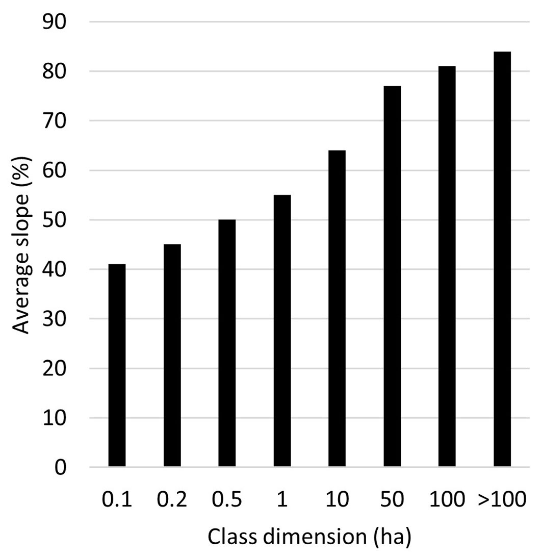
In terms of ownership, the total number of cadastral parcels classified as forest in the mountain area of Friuli Venezia Giulia is 559,889, and in Friuli private forest properties in many cases, consist of a single or a few cadastral parcels. Their average size is 6,054 m2, though their size distribution is asymmetric: 93% of them have an area < 1 ha (46% are even smaller than 1000 m2), while only 0.14% exceeds 100 ha (Fig. 3). A similar pattern has been previously reported for some specific and limited areas of the region ([2]), and can be considered as common situation throughout the Italian Alps with the exception of the Trentino Province, where most of the forest properties are public and thus are characterized by larger cadastral parcels ([15]). Most of the smallest parcels are located at the bottom of the valleys on almost flat terrains and near human settlements (Fig. 4), probably because they were previously cultivated or used as grasslands or pastures. Following the socio-economic changes occurred in the Alps in the last century, these traditional practices were gradually abandoned and forest secondary successions have been taking place ([12]). On the contrary, larger parcels are frequently located at higher altitudes and on steeper slopes because they were mainly public properties, managed for production or protection. Such a size distribution underlines again the difficulties in implementing a proper and shared forest management throughout the region.
Fig. 3 - Distribution of the cadastral parcels’ size in Friuli Venezia Giulia region (NE Italy).
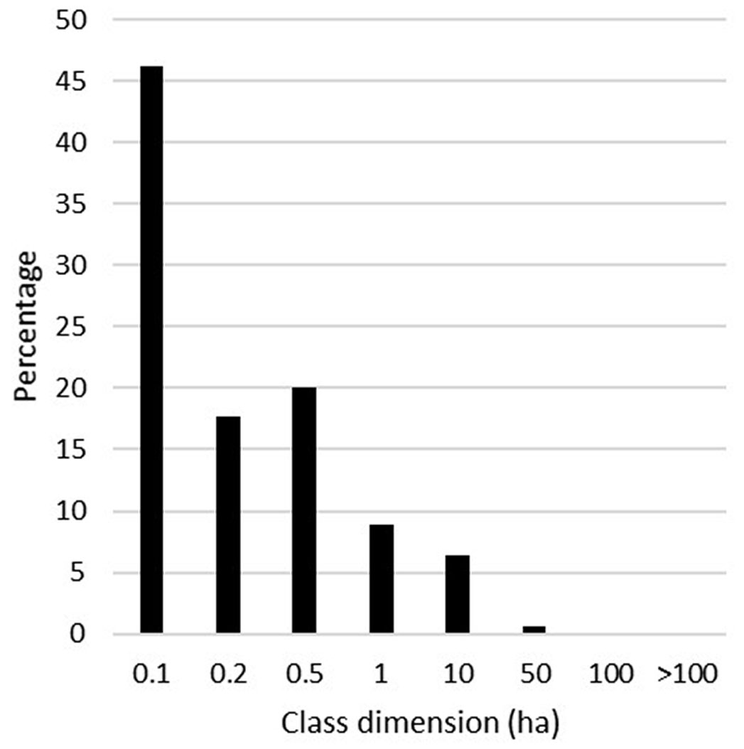
Fig. 4 - Cadastral parcels class dimension by average percentage slope derived from DTM.
Several FDSSs have been proposed in Italy in recent years, but most of them are not properly real tools available for end users, being rather approaches and methodology developed in research programs ([32]). Some of them are mainly focused on mapping forest accessibility and optimizing woody biomass extraction ([42], [33]), and others at local scale ([24], [38]). In the case of the Pri.For.Man. DSS, new specific thematic layers related to standing volume, current annual increment and forest accessibility are made available at regional scale together with all the existing information on the regional forest resources, including legal and environmental constraints. The unique analogue system found has been developed for a small forest area in the southern Italy, reporting in some cases similar information ([24]). The Pri.For.Man. DSS allows single or groups of owners, also with poor ICT knowledge, to derive, at the level of a single cadastral parcel, information about stand species composition, structure, volume, wood increment, accessibility, as well as to support the identification of the best silvicultural interventions. Moreover, since the WebGIS interface allows to export the data of a specific cadastral parcel in Excel®, such information can also be used to fill in the management documents required by the regional regulations.
Compared to other FDSS, the system also attempts to integrate a cost analysis related to the different harvesting logistic options. Despite some criticism on harvesting costs (since data were collected in previous years and therefore they do not consider the changes caused by the recent raw materials crisis) the Pri.For.Man. DSS can provide a rough estimation of potential harvesting costs thus supporting the planning of a harvest logistic.
In terms of applicability and usability, several authors state that the stakeholders engagement is fundamental during the design phase and the implementation of this type of tools ([34], [39], [29]). For these reasons, the system here presented was developed with an active consultation of local stakeholders and forest technicians. In the follow-up phase, the involved stakeholders considered the FDSS easy to use and versatile in providing a framework on the forest characteristics, as well as on the environmental constraints. Furthermore, thanks to the tutorial (⇒ https://youtu.be/oNV8eiTcv_M), the system can be potentially also used by non-professionals (owners and public administrations) who wish to acquire information on their own forests, taking in mind the importance of training ([39]). Finally, as far as transparency is concerned ([34]), all the information on how the data were created are reported.
Conclusions
DSSs in forestry are fundamental tools to share knowledge and promote an active and sustainable management. The Pri.For. Man. DSS presented here has two important added values when compared to other systems: the reuse of spatial data made available in a structured way; the use of two open-source tools that act as the core of the system. Although the system was tested online in a restricted mode for a limited period of time (6 months) and thus it is still difficult to make a proper quantitative and qualitative evaluation of its overall applicability, it has raised interest among regional officials and forest technicians. The information provided by this new DSS could help raising awareness on the potential environmental and economic values of the natural capital among various operators, from single enterprises to local municipalities. Moreover, this tool constitutes a comprehensive informative framework on the forest features at regional and local scale, allowing the extraction of relevant forest statistics for the implementation of future management activities. The main concern is to consolidate the application and evolve from a research-oriented to a full operative product, looking for a stronger cooperation between the regional Forest services and local enterprises.
Acknowledgments
We would like to thank the Forest service of the Autonomous Region Friuli Venezia Giulia, and all the involved partners: Danta Legnami e Biomasse srl, Legno Servizi Società Cooperativa, Consorzio Comunità di Rutte - Dorfschaft Greuth, Società Agricola Dolomitis Legnami ss, Impresa forestale Vuerich Gregorio, and the project manager Maurizio Trevisan. Information on wood volume and increment processed from the original plot data of Carabinieri, Council for agricultural research and analysis of the agricultural economy - National Inventory of Forests and forest carbon reservoirs (INFC, ⇒ https://www.inventoryforest.org/) released under the Creative Commons Attribution 4.0 license. Cartographic data from Autonomous Region Friuli Venezia Giulia was downloaded from the IRDAT catalogue and released under the Italian Open Data License v2.0 (IODL 2.0).
Contributions
GA, LC, FG, AT and GC: conceptualization. LC, GA and AT methodology. ADL and LC software. LC geoprocessing and data curation. GA and GC supervision. GA funding acquisition. LC, FG, GA, AT and ADL writing, review and editing.
Funding
The project was funded by the European rural development program of Autonomous Region Friuli Venezia Giulia, measure 16.1.1, decree n. 422/AGFOR of 22/01/2020 and by the National Recovery and Resilience Plan (NRRP), Mission 4 Component 2 Investment 1.4, Agritech National Centre. LC was supported by the Programma Operativo Nazionale Ricerca ed Innovazione (PON) PhD scholarship (DM 1061/2021).
References
Gscholar
Gscholar
Online | Gscholar
CrossRef | Gscholar
CrossRef | Gscholar
CrossRef | Gscholar
Gscholar
CrossRef | Gscholar
Authors’ Info
Authors’ Affiliation
Antonio Tomao 0000-0001-6656-400x
Giorgio Alberti 0000-0003-2422-3009
Department of Agricultural, Food, Environmental and Animal Sciences, University of Udine, I-33100 Udine (Italy)
Department of Life Sciences, University of Trieste, I-34127 Trieste (Italy)
Gherardo Chirici 0000-0002-0669-5726
Department of Agricultural, Food, Environmental and Forestry Sciences and Technologies, University of Florence, I-50145 Firenze (Italy)
Adl.cloud, I-33100 Udine (Italy)
Faculty of Agriculture, Environmental and Food Sciences, Free University of Bolzano, I-39100 Bolzano (Italy)
Corresponding author
Paper Info
Citation
Cadez L, Giannetti F, De Luca A, Tomao A, Chirici G, Alberti G (2023). A WebGIS tool to support forest management at regional and local scale. iForest 16: 361-367. - doi: 10.3832/ifor4445-016
Academic Editor
Marco Borghetti
Paper history
Received: Aug 09, 2023
Accepted: Oct 16, 2023
First online: Dec 13, 2023
Publication Date: Dec 31, 2023
Publication Time: 1.93 months
Copyright Information
© SISEF - The Italian Society of Silviculture and Forest Ecology 2023
Open Access
This article is distributed under the terms of the Creative Commons Attribution-Non Commercial 4.0 International (https://creativecommons.org/licenses/by-nc/4.0/), which permits unrestricted use, distribution, and reproduction in any medium, provided you give appropriate credit to the original author(s) and the source, provide a link to the Creative Commons license, and indicate if changes were made.

Web Metrics
Breakdown by View Type
Article Usage
Total Article Views: 5234
(from publication date up to now)
Breakdown by View Type
HTML Page Views: 4166
Abstract Page Views: 601
PDF Downloads: 421
Citation/Reference Downloads: 4
XML Downloads: 42
Web Metrics
Days since publication: 143
Overall contacts: 5234
Avg. contacts per week: 256.21
Article Citations
Article citations are based on data periodically collected from the Clarivate Web of Science web site
(last update: Feb 2023)
(No citations were found up to date. Please come back later)
Publication Metrics
by Dimensions ©
Articles citing this article
List of the papers citing this article based on CrossRef Cited-by.
Related Contents
iForest Similar Articles
Review Papers
Remote sensing-supported vegetation parameters for regional climate models: a brief review
vol. 3, pp. 98-101 (online: 15 July 2010)
Review Papers
Accuracy of determining specific parameters of the urban forest using remote sensing
vol. 12, pp. 498-510 (online: 02 December 2019)
Review Papers
Remote sensing of selective logging in tropical forests: current state and future directions
vol. 13, pp. 286-300 (online: 10 July 2020)
Technical Reports
Detecting tree water deficit by very low altitude remote sensing
vol. 10, pp. 215-219 (online: 11 February 2017)
Review Papers
Remote sensing support for post fire forest management
vol. 1, pp. 6-12 (online: 28 February 2008)
Research Articles
Development of monitoring methods for Hemlock Woolly Adelgid induced tree mortality within a Southern Appalachian landscape with inhibited access
vol. 9, pp. 178-186 (online: 02 January 2016)
Research Articles
Assessing water quality by remote sensing in small lakes: the case study of Monticchio lakes in southern Italy
vol. 2, pp. 154-161 (online: 30 July 2009)
Research Articles
Afforestation monitoring through automatic analysis of 36-years Landsat Best Available Composites
vol. 15, pp. 220-228 (online: 12 July 2022)
Technical Reports
Remote sensing of american maple in alluvial forests: a case study in an island complex of the Loire valley (France)
vol. 13, pp. 409-416 (online: 16 September 2020)
Research Articles
Evaluation of hydrological and erosive effects at the basin scale in relation to the severity of forest fires
vol. 12, pp. 427-434 (online: 01 September 2019)
iForest Database Search
Search By Author
Search By Keyword
Google Scholar Search
Citing Articles
Search By Author
Search By Keywords
PubMed Search
Search By Author
Search By Keyword


