Impact of rainfall intensity and cutslope material on sediment concentration from forest roads in northern Iran
iForest - Biogeosciences and Forestry, Volume 7, Issue 1, Pages 48-52 (2014)
doi: https://doi.org/10.3832/ifor0097-007
Published: Oct 21, 2013 - Copyright © 2014 SISEF
Research Articles
Abstract
Forest roads are important for adequate management of natural resources, but they are also a dominant contributor of sediment to forest streams and water pollution. This study measured road sediment concentration from forest roads to determine the impact of rainfall intensity and cutslope types on sediment concentration in the Patom district of northern Iran. Two 110 m road segments with variable soil and rock fragment cover exposed at the cutslopes were studied. Seven rainfall and corresponding runoff events were measured in 1-liter bottle samplers every 10 minutes at the outlet of cross sectional culverts, and from two 3 m2 plots on the roadbeds adjacent to each cutslope. A statistically significant difference at the 95% confidence level between two cutslope types and rainfall intensity on sediment concentration was determined from the field data based on nonparametric tests, though no statistically significant difference in the concentration of sediment between the two roadbeds plots were found. The average of sediment concentration of soil trench and the rock fragment cover cutslopes were 60.3 and 46.8 g/l, respectively. The results reported here should help forest road managements to improve the understanding of cutslopes erosion and sediment production from forest roads and to employ suitable methods to reduce sediment production.
Keywords
Forest Road, Cutslope, Rainfall Intensity, Rock Fragment, Sediment Concentration
Introduction
Forests support a lot of ecosystem services, including primary products, secondary products, water supply, hydrological regulation, environmental purification, soil formation, soil conservation, biodiversity conservation, recreation, etc ([15]). In order to facilitate forestry operations in managed areas, a well developed network of roads is fundamental ([2]), providing access for management, wood utilization, ecotourism activities and fire control. In this context, suitable forest roads are crucial for sustainable management of forest resources. Nonetheless, forest roads are also recognized as a major source of erosion and can account for as much as 90% of all sediment production in forested watersheds ([40]). Erosion and sediment delivery to forest streams is a source of water pollution and global management problems. Previous studies have indicated that erosion rates are very low in natural and undisturbed forests ([8], [33], [9]). Sediment production rates from unpaved road surfaces have been estimated several orders of magnitude higher than undisturbed hillslopes ([25], [26], [27], [5]). Forests roads cause many local changes in the forested environments and induce changes to soil properties and hydrologic behavior of hillslopes, increase soil erosion and the incidence of mass movements ([13], [38], [20], [14]). The main factors that cause increased sediment delivery to forest streams are removing plant cover along the forest road pathway, compaction of the soil in the roadbed, interception of surface and sub-surface flows, constructions of cutslopes, and alteration of hillslope water pathways ([41]). Sediment delivered to forest streams cause water resource pollution, filling dams and may have impacts on aquatic habitat ([7], [34], [17], [18]).
Three methods are typically used to measure sediment produced from forest roads: (1) measurement in natural conditions with natural precipitation events (e.g., direct measurements from outlet of live streams culverts or using sediment traps - [21], [22], [37], [30], [39]); (2) use of a rainfall simulator ([23], [10]); and (3) use of empirical and physical sediment prediction models ([3], [9], [18]). Although field quantification methods are costly and time consuming ([11]), they should be preferred because sediment delivery occurs most efficiently at road-stream crossing where virtually most of the generated sediment is delivered to the streams ([19], [6]).
A potentially important contribution to forest road sediment production may come from cutslopes ([22], [23]). Ramos-Scharrón & MacDonald ([33]) showed that cutslope areas are responsible for about 9% of the total road segment sediment production. Luce & Black ([22]) examined the relationship between sediment production and road attributes such as distance between culverts, road gradient, road texture, and vegetation cover on cutslope. Their study indicated that sediment production was not correlated to the cutslope height, but sediment yield from cutslopes with cleared vegetation cover was about 7 times more than from road segments where vegetation was retained. Akay et al. ([3]) estimated sediment from forest roads delivered to streams using the SEDMODL model and GIS techniques. They showed that reducing rock cover of cutslopes caused a significant increase in sediment yield. In addition, they showed that in seasons with high intensity rainfalls, a considerable amount of sediment production in road sections with low quality surfacing might occur. Ramos-Scharrón & MacDonald ([33]) quantified sediment production and delivery rates in a dry tropical environment. They reported that cutslope sediment rates ranged from 20 to 170 Mg ha-1 yr-1, and unpaved roads had sediment production rates between 57 Mg ha-1 yr-1 for road with 2% slope up to 580 Mg ha-1 yr-1 for a road with 11% slope. Moreover, their study showed that unpaved roads were a dominant source of sediment and responsible for a 3-9 times increase in watershed-scale sediment yield relative to undisturbed conditions. Jordán-López et al. ([23]) in the Mediterranean area measured the impact of different parts of unpaved forest roads on runoff and sediment yield. They used a simple portable rainfall simulator on the cutslope, fillslope, and on the roadbed. They showed that cutslopes are the main source of sediment on forest roads with 486.7 g m-2 per storm. Total soil erosion on cutslopes was 3 and 18 times higher than those from the roadbeds and fillslopes, respectively.
Given the importance of erosion and sediment production from forest roads, knowledge of the road segments potential for erosion and impact of rainfall intensity on sediment production can help forest managers to identify sensitive segments for erosion control operations. Therefore, the objectives of this study were to: (1) assess the effect of different rainfall intensities on forest road sediment concentration; and (2) assess the role of two different cutslope types in sediment concentration in the Patom district in Iran.
Material and methods
Study site
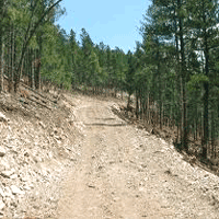
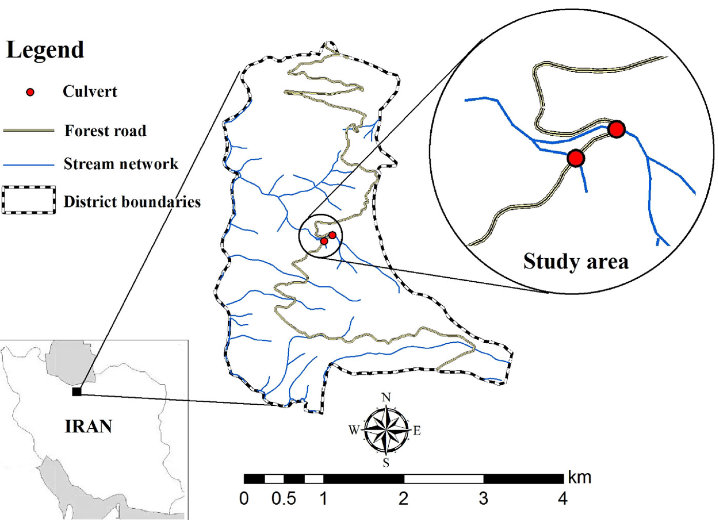
The study area was located in the Patom district in the Kheyrud Forest Research Station of Tehran University, which is located at approximately 36° 38’ N and 50° 34’ E (Fig. 1). The Patom district has a 900 ha drainage area and ranges from 0 and 934 m a.s.l. in elevation. Average annual rainfall is 1300-1500 mm. The mean air temperature is 16.1 °C. The average of stand volume is about 55.76 m3 ha-1, dominant stand height 25-30 meters, 70% canopy cover and 263 stems ha-1. Dominant tree species are Carpinus betulus (Hornbeam), Fagus orientalis (Oriental Beech) and Parrotia persica (Persian Ironwood). The lithological substrate is mainly calcareous parent material and the associated soil types are Inceptisols and Alfisols ([36]). The length of the road network in the district is 16.3 km, with an average density of 18.1 m ha-1. Unpaved forest roads ascending from 620 m to 650 m a.s.l. were selected for this experiment. This road is used by wood utilization vehicles such as tracks and skidders and other passenger cars such as jeeps and touring cars.
Fig. 1 - Road network of Patom district (northern Iran) and location of studied culverts.
Methods
All culverts from the Patom district’s road were geo-referenced using a GPS receiver (GARMIN, COLORADO 300) and were exported to ArcGIS Desktop 9.3 as a map layer. Two live stream culverts along the road network were selected for sediment measurements after field observation, each representing two different types of cutslopes. Vegetation cover and rock fragment cover were determined using a 50 cm × 50 cm grid with cells of 0.25 cm2 ([23]). The slope angle of the soil surface on each cutslope was determined using a clinometer. Two selected cutslopes were similar in averages, with 30% gradient, 3 m slope length, and about 10% vegetation cover, but they were different in material. One cutslope had exposed more than 70% of soil (henceforth named “Soil Cutslope”), and the other had exposed more than 70% rock fragment cover (named “Rock Cutslope”). The width of the road was about 5.5 m with a moderate gradient ranging between 6-11% ([21]). The other road characteristics were the same for two road sections (Tab. 1).
Tab. 1 - Relevant characteristics of the cutslopes considered in this investigation.
| Characteristic | Soil cutslope | Rock fragment cutslope |
|---|---|---|
| Lithology | Calcareous | Calcareous |
| Soil | Inceptisol & Alfisol | Inceptisol & Alfisol |
| Gradient (classify) | Medium | Medium |
| Travel way material | Graveled | Graveled |
| Vegetation cover | Non (Removed) | Non (Removed) |
| Width (m) | 5.5 | 5.5 |
| Age (years) | 24 | 24 |
| Length (m) | 110 | 110 |
| Cutslopes | >70% soil | >70 rock fragment |
On both road segments, two 3-square-meters (3×1 m) bordered plots (3 m selected as plots length because it was equal to cutslopes slope length) were located randomly and installed using sheet metal borders with a runoff apron on the roadbed surface at the bottom of road length slope. The plots were named “Rplot” and “Splot” as they were located on the roadbeds associated to “Rock Cutslope” and “Soil Cutslope” road segments, respectively. Seven rainfall events were measured with a cylindrical, manual rain gauge, and samples of the sediment suspended were collected in 1-liter sampler bottles at every 10 min intervals from roadbed plots and at the outlet of culverts that accommodates runoff from roadbeds and cutslopes.
Sediment suspended concentration was carried out by decanting and filtering through a Wathman No. 42 paper under suction on a Buchner funnel in the lab ([12]). Papers containing sediment were then weighted and placed in a drying oven for 24 hours at about 105 °C ([29]).
The sediment contribution from cutslopes at the road segment scale was derived by subtracting roadbed sediment from the sediment that flows to the culvert outlet, which contains runoff from both the roadbed and the cutslope.
Average rainfall intensity was obtained by dividing rainfall height (mm) to rainfall duration (hour). According to Mahdavi ([28]) average rainfall intensity was classified as follows: (1) light rain (intensity < 2.5 mm h-1); (2) moderate rain (intensity between 2.5 and 7.5 mm h-1); and (3) heavy rain (intensity > 7.5 mm h-1).
Data analysis
Kolmogorov-Smirnov normality test (α = 0.05) was initially applied to verify normal distributions of the variables considered ([35]). Kruskal-Wallis test was used to verify the null hypothesis of no impact of rainfall intensity on the sediment production from forest roads, while Mann-Whitney U test was applied to verify the null hypothesis of no differences in sediment productions from the two cutslope types ([35], [23]).
The relationship between average rainfall intensity and sediment concentration to the road culverts was analyzed using simple regression analysis of log-tranformed data.
Results
Seven rainfall events were measured and classified as light rain, moderate rain and heavy rain. Rainfall intensity ranged between 2.2 up to 10.8 mm h-1 in the studied area. The number of rainfall events and the number of samples considered for each plot is reported in Tab. 2.
Tab. 2 - Number of rainfall events and sediment samples in each rainfall intensity classification.
| Parameters | Rainfall event | Samples |
|---|---|---|
| Light rain | 1 | 39 |
| Moderate rain | 4 | 36 |
| Heavy rain | 2 | 32 |
| Total | 7 | 107 |
All the variables analyzed did not show significant departures from normality after Kolmogorov-Smirnov test (P ≥ 0.05 - Tab. 3). Pooling data from the two plots analyzed, significant differences (P ≤ 0.001) among rainfall intensity classes were found after Kruskal-Wallis ANOVA: as rainfall intensity increases, sediment delivery increases accordingly (Tab. 4).
Tab. 3 - Results of Kolomogrov-Smirnov Normality Test. (N): number of samples collected during rainfall events.
| Normality test | Soil Cutslope ± SD |
Rock Cutslope ± SD |
|---|---|---|
| Mean | 60.32 ± 16.41 | 46.79 ± 26.42 |
| N | 57 | 50 |
| Prob. | 0.469 | 0.58 |
Tab. 4 - Relationship between rainfall intensity classes and total sediment concentration (g/L). Kruskal-Wallis ANOVA, P ≤0.001**.
| Rainfall Classes | Mean Sediment Concentration (g/l) ± SD |
|---|---|
| 1 | 14.9 ± 6.81 |
| 2 | 52.2 ± 21.32 |
| 3 | 74.1 ± 30.56 |
Significant differences in sediment delivery were also observed between the two cutslop types considered (Kruskal-Wallis ANOVA - P ≤ 0.001). Hence, sediment concentration increased with rainfall intensity for both segment roads, but sediment concentration for the soil dominated cutslope was significantly higher than the rock dominated cutslope for any rainfall intensity class (Tab. 5).
Tab. 5 - Relationship between rainfall intensity classes and sediment delivered from road with rock fragment cutslope. Kruskal-Wallis ANOVA, P≤0.001*.
| Rock Cutslope | Soil Cutslope | ||
|---|---|---|---|
| Rainfall classes |
Sediment mean (g/l) ± SD |
Rainfall classes |
Sediment mean (g/l) ± SD |
| 1 | 6.0 ± 3.1 | 1 | 9.5 ± 4.7 |
| 2 | 16.6 ± 7.5 | 2 | 26.1 ± 11.3 |
| 3 | 32.4 ± 15.8 | 3 | 42.7 ± 21.4 |
Mann-Whitney non-parametric test applied to data pooled over rainfall classes revealed significant differences between the two cutslope types (P = 0.024), confirming that on average sediment produced from the soil cutslope was higher than the rock fragment cutslope. On the other hand, we did not find any significant difference between Rplot and Spolt for the two roadbeds associated to the cutslopes (Tab. 6).
Tab. 6 - Mann-Whitney test to compare sediment concentration from two cutslope types and roadbeds plots.
| Cases | Mean of Sediment (g/l) ± SD |
Sediment Percentage (%) |
P |
|---|---|---|---|
| Soil Cutslope | 60.3 ± 26.4 | 91 | 0.024* |
| Splot | 6.1 ± 2.9 | 9 | - |
| Rock Cutslope | 46.8 ± 16.4 | 80 | 0.215 |
| Rplot | 11.6 ± 7.4 | 20 | - |
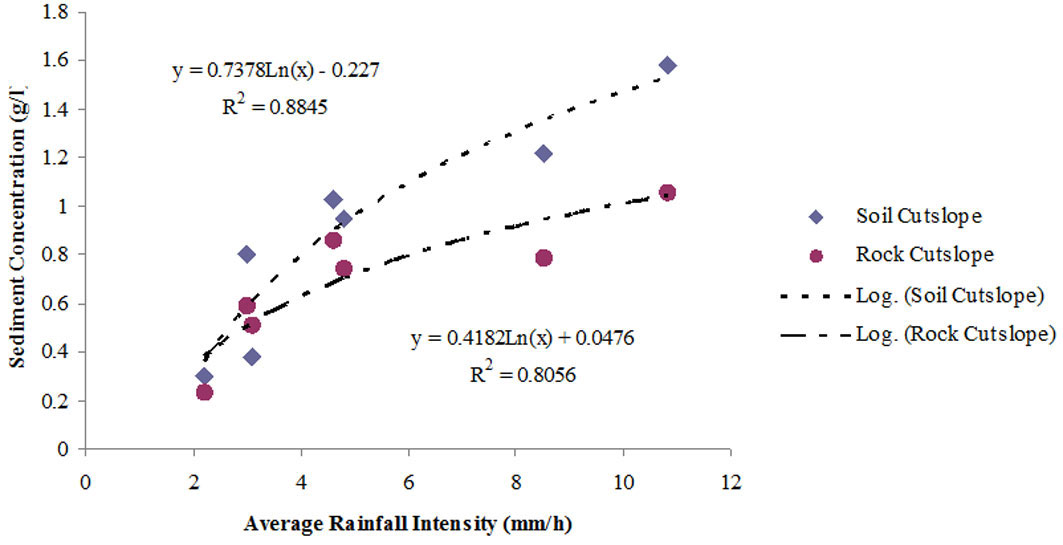
Results from the regression analysis showed that the relationship between the average rainfall intensity and the sediment concentration to the culverts from the two roads fits fairly well to a logarithmic function (Fig. 2). It is worth to notice that differences in sediment concentration between the two cutslope types becomes obvious for high-intensity events, while both types have very similar concentrations for low-intensity values of rainfall intensity.
Fig. 2 - Logarithmic relationship between average of rainfall intensity and sediment concentration.
Discussion
In undisturbed forest systems, the kinetic energy of raindrops or water flow on the surface are reduced by tree canopy and soil litter, thus lessening soil erosion. Wischmeier & Smith ([42]) observed that kinetic energy of rainfall increases with rainfall intensity with a logarithmic rule. Young & Wiersma ([43]) showed that the impact energy of raindrops is the major force initiating soil detachment in a rainfall-simulation on three different soils. The mechanism by which a soil particle is detached from bulk soil mass is tensile failure ([31]). The soils particles must be detached from the bed against the resisting force of inter aggregate cohesion and their weight. Therefore when rainfall intensity increases, kinetic energy increases and soil particles with bigger size detach. Some of the soil big particles settled or trapped by vegetation and rubbles in the runoff path, also vegetation dissipates the runoff energy, this cause increases sediment with rainfall intensity had logarithmic relationship not linear relationship (Fig. 2, Tab. 4, Tab. 5). MacDonald & Coe ([24]) indicated that one factor affecting surface erosion from forest road surface is rainfall intensity (Fig. 2). Akay et al. ([3]) indicated that the effect of total precipitation was low on sediment production, but considerable amounts of sediment are produced during intense rainfall events. This is in agreement with our results, as different amounts of sediment were produced from cutslopes under different rainfall intensities (Tab. 4, Tab. 5).
The two roadbed segments associated to the two cutslope types were similar as for the material (Tab. 1) and construction method; we expected that sediment concentration from these segments would not display significant differences, and this hypothesis was supported by our findings (Tab. 6). So cutslope sediment concentration was derived by subtracting roadbed plots sediment to sediment samples collected from the outlet of culverts that accommodates runoff from roadbeds and cutslopes in each rainfall event. Our hypothesis agreed with our finding that roadbeds with similar materials and construction methods do not have a statistically different sediment concentration (Tab. 6) and therefore any difference in sediment concentration at the road outlet is due to the differences in the cutslope properties.
According to Poesen & Lavee ([32]) the influence of surface rock fragments on sediment yield from bare interrill areas largely depends on the effects of rock fragments on sub-surface flow and on sediment concentration. On the cutslope the rock fragments at the surface increased the roughness and the interception of raindrops, reducing soil detachment and sediment production. Jordán & Martínez-Zavala ([16]) observed that, in non-vegetated cutslopes, rock fragment cover may protect the soil surface from erosion. Jordán-López et al. ([23]) stated that the cutslope cover and rock fragment on soil texture are important factors for reducing runoff and sediment production. These results support our finding that cutslope material and type is effective on the sediment production.
Due to compaction of the soil surface, roadbeds had lower sediment concentration than cutslopes (Tab. 6). This finding is supported by Jordán & Martínez-Zavala ([16]) and Jordán-López et al. ([23]) who showed that sediment produced from roadbed was lower than cutslope.
Soil losses from forest roads require reconstruction and maintenance costs, and these encompass the majority of costs in forest management plans ([1]). Sediment suspended cause forest streams and aquatic habitat pollution. Boyd ([4]) observed that sediment suspended concentration higher than 20 g/l in streams cause confusion and disorder in the behavior of aquatic species. Although this study did not measure sediment suspended concentration in forest streams and aquatics habitats, it provides some information for forest managers to consider the roadbed and cutslope surface, and method to reduce sediment production and reduce stream pollution.
Conclusions
The cutslopes are the main source of sediment production (80-91%) on forest roads in northern Iran. For the two roads and road cutslopes, measured rainfall intensity was an important factor on detachment and delivery of sediment to streams.
Increasing rainfall intensity increased sediment concentration from two forest road segments. The road with a cutslope dominated by loose soil produced runoff with a higher sediment concentration than the cutslope dominated by a rock fragment cover.
Rock fragment cover is an important factor that conditions sediment concentrations on the road cutslopes. Also sediment produced from roadbeds was lower than cutslopes and there was not significant difference between two roadbeds with similar materials, construction method and age.
Forest roads managements should pay more attention to more sensitive sections of forest roads and road maintenance activities (such as increasing plant cover or rock fragment percentage) in order to reduce sediment production and prevent water pollution.
References
Gscholar
Gscholar
Gscholar
Gscholar
Gscholar
Gscholar
Gscholar
Gscholar
Gscholar
Gscholar
Gscholar
Gscholar
Gscholar
Gscholar
Gscholar
Authors’ Info
Authors’ Affiliation
Baris Majnounian
Ehsan Abdi
Forestry and Forest Economics Department, Faculty of Natural Resources, University of Tehran, Karaj (Iran)
Range and Watershed Management Department, Faculty of Natural Resources, University of Tehran, Karaj (Iran)
Department of Forest Engineering, Resources and Management College of Forestry, Oregon State University, Corvallis, OR (USA)
Corresponding author
Paper Info
Citation
Rahbari Sisakht S, Majnounian B, Mohseni Saravi M, Abdi E, Surfleet C (2014). Impact of rainfall intensity and cutslope material on sediment concentration from forest roads in northern Iran. iForest 7: 48-52. - doi: 10.3832/ifor0097-007
Academic Editor
Roberto Tognetti
Paper history
Received: Mar 14, 2012
Accepted: Apr 08, 2013
First online: Oct 21, 2013
Publication Date: Feb 03, 2014
Publication Time: 6.53 months
Copyright Information
© SISEF - The Italian Society of Silviculture and Forest Ecology 2014
Open Access
This article is distributed under the terms of the Creative Commons Attribution-Non Commercial 4.0 International (https://creativecommons.org/licenses/by-nc/4.0/), which permits unrestricted use, distribution, and reproduction in any medium, provided you give appropriate credit to the original author(s) and the source, provide a link to the Creative Commons license, and indicate if changes were made.

Web Metrics
Breakdown by View Type
Article Usage
Total Article Views: 56563
(from publication date up to now)
Breakdown by View Type
HTML Page Views: 47400
Abstract Page Views: 3282
PDF Downloads: 4406
Citation/Reference Downloads: 14
XML Downloads: 1461
Web Metrics
Days since publication: 4590
Overall contacts: 56563
Avg. contacts per week: 86.26
Article Citations
Article citations are based on data periodically collected from the Clarivate Web of Science web site
(last update: Mar 2025)
Total number of cites (since 2014): 5
Average cites per year: 0.38
Publication Metrics
by Dimensions ©
Articles citing this article
List of the papers citing this article based on CrossRef Cited-by.
Related Contents
iForest Similar Articles
Technical Reports
Qualitative evaluation and optimization of forest road network to minimize total costs and environmental impacts
vol. 5, pp. 121-125 (online: 05 June 2012)
Technical Reports
Decision making in forest road planning considering both skidding and road costs: a case study in the Hyrcanian Forest in Iran
vol. 6, pp. 59-64 (online: 21 January 2013)
Research Articles
Slope shape effect on runoff and soil erosion under natural rainfall conditions
vol. 7, pp. 110-114 (online: 18 December 2013)
Research Articles
Soil stoichiometry modulates effects of shrub encroachment on soil carbon concentration and stock in a subalpine grassland
vol. 13, pp. 65-72 (online: 07 February 2020)
Research Articles
Temporal analysis of the traffic loads on forest road networks
vol. 6, pp. 255-261 (online: 13 June 2013)
Short Communications
Not all long-distance-exploration types of ectomycorrhizae are the same: differential accumulation of nitrogen and carbon in Scleroderma and Xerocomus in response to variations in soil fertility
vol. 14, pp. 48-52 (online: 18 January 2021)
Research Articles
Different harvest intensity and soil CO2 efflux in sessile oak coppice forests
vol. 9, pp. 546-552 (online: 25 March 2016)
Research Articles
The effect of soil conditions on submountain site suitability for Norway spruce (Picea abies Karst.) in Central Europe
vol. 16, pp. 210-217 (online: 31 July 2023)
Research Articles
Soil CO2 efflux in uneven-aged and even-aged Norway spruce stands in southern Finland
vol. 11, pp. 705-712 (online: 06 November 2018)
Research Articles
Impacts of Norway spruce (Picea abies L., H. Karst.) stands on soil in continental Croatia
vol. 12, pp. 511-517 (online: 02 December 2019)
iForest Database Search
Search By Author
Search By Keyword
Google Scholar Search
Citing Articles
Search By Author
Search By Keywords
PubMed Search
Search By Author
Search By Keyword


