
Wildfire risk and its perception in Kabylia (Algeria)
iForest - Biogeosciences and Forestry, Volume 11, Issue 3, Pages 367-373 (2018)
doi: https://doi.org/10.3832/ifor2546-011
Published: May 04, 2018 - Copyright © 2018 SISEF
Research Articles
Abstract
This research aims to study wildfire perception by residents living in Wildland Urban Interface (WUI) in Kabylia (Algeria). We conducted an exploratory qualitative survey contacting 254 randomly selected individuals in eight hamlets of the Mizrana forest. Face-to-face questionnaires were administered to understand the fire risk problem. Respondents think that their homes are not exposed to fire risk and perceive their hamlets are protected against wildfires; on the contrary, they perceive their property (fields, livestock, olive trees, etc.) as exposed to fire risk. The vast majority of respondents declare to know how to defend themselves in the case of a fire event, using water and hand tools. Residents mainly use fire for stubble burning and disposal of domestic waste. Their skill in using fire as a land management tool respectively comes from their fathers, grandfathers and mothers. Results show the necessity of making resident more aware of the risks that wildfires pose to them. A culture of risk needs to be developed within the territory to limit vulnerability and the likelihood of destructive fires.
Keywords
Algeria, Fire Use, Mizrana Forest, Risk Perception, TEK, Wildland Urban Interface, Wildfire
Introduction
A marked increase in the number of wildfires, which are very frequent in the five Southern member States of European Union is currently registered also in the Southern Mediterranean rim, namely in Tunisia, Morocco, Lebanon ([15]), and above all in Algeria ([32]), hitherto considered with a low fire incidence level ([1]). Forests cover approximately 3.7 million hectares (only 1.5% of the land area) in Algeria, half of which are degraded forest or maquis ([37]), concentrated in some wilayas (provinces) of the Northern part of the country, with a negative gradient East-West. Algerian forests are currently in a critical state ([13]) due to human activities ([31]), which add a negative impact to the extreme climatic factors of the country (heat waves in combination with drought - [14], [8], [20]). Fire, extensive livestock breeding, overgrazing, clearing, illegal forest harvesting, and urbanization contribute to forest degradation.
The most recent available statistical data (1985 to 2014) report an average of 1.912 fires and 36.205 hectares of area burned annually, rather exclusively as a result of negligent or malicious anthropic activities ([32]). The number of wildfires exhibits an increasing trend, whereas burned surfaces follow a rather stable or slightly decreasing one.
Notwithstanding the importance of wildfire phenomenon, which strongly affects densely inhabited areas with high levels of damage and frequent life loss ([33]), Algeria has a scarce presence in the current international wildfire literature, mainly dealing with post fire regeneration and remote sensing ([38], [28], [35], [4], [22], [39], [5]). Recent research papers ([33], [34], [29], [31]) have examined the causes of wildfires and the organization of the institutional fire fighting apparatus. No reference exists, according to our knowledge, about the perception of wildfires by residents; however, this kind of research is almost absent also in the countries of the Northern Mediterranean rim ([16], [27]). Hence, our interest was to carry out a first exploratory analysis about perceptions of wildfire risk associated with living in or near the forested area of the Mizrana forest, considered well representative of the most general conditions of Kabylia.
In Mizrana, most fires are linked to rural habitats scattered along the roads, which generate consumption of space and other problems, such as the use of fire for the disposal of household refuse. They are the result of an unplanned urban sprawl, that allows individuals to build close to vegetation or even to embed their houses within it, thus settling in harms’ way, since the link between fires and urban spaces in proximity of forests is more than a hypothesis ([10], [42], [9], [18]).
The factors that increase fire risk (e.g., structure and type of vegetation, its proximity to house, lack of defensible space) are the very elements that satisfy the search of amenity by new residents and represent what they appreciate within the landscapes in which they have decided to reside. Building homes at risk of wildfires because they like being surrounded by trees, can be defined as “amenity risk” ([6], [25]).
Material and methods
Study area
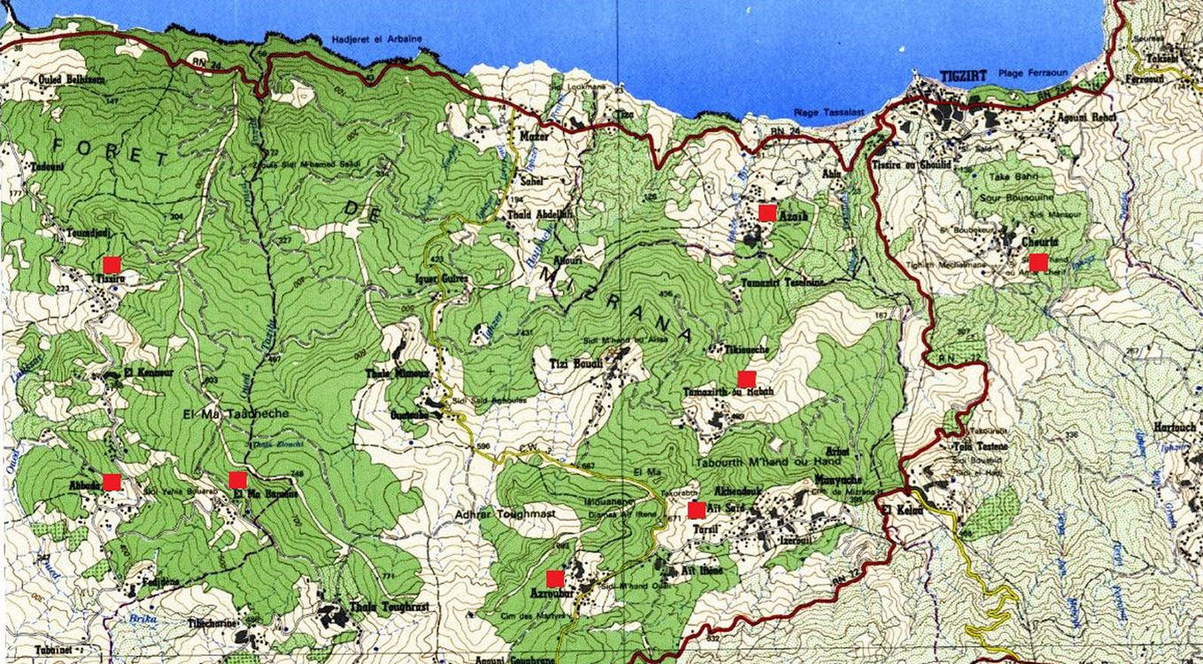
The study area is represented by the domanial natural forest of Mizrana (2.233 ha), located in the low elevation coastal area of Kabylia (Fig. 1).
Fig. 1 - Excerpt of the topographic map 1:50.000. Green areas represent the Forest of Mizrana, in the wilayas of Tizi Ouzou and Boumerdes (Algeria). Hamlets (represented by red squares) are mainly located along roads or close to the forest edge.
The climate is a subhumid Mediterranean type, with temperate variation. The vegetation is represented by cork oak (Quercus suber L.) stands, whose undergrowth is dominated by Arbutus unedo L., Erica arborea L., Rubus ulmifolius Schott, Myrtus communis L. and Phillyrea media L.
The Mizrana forest is subject to harmful practices and has been affected by recurrent wildfires; during the period 1988-2013, 113 fires burned an area of 2.036 ha ([23]). Fires can be explained, among others, by the elimination of the forest to recover spaces to be built, as already shown for Spain by Gonzalez ([19]) and for Greece by Bassi & Kettunen ([2]).
The study area is densely inhabited (up to 287 habitants km-2) with the population distributed in clusters of hamlets near the forested areas, or close to their edges.
Traditional agriculture still occupies an important place in Kabylia: it is based on breeding (sheep, cattle and goats), arboriculture (olive and fig trees) and vegetable crops. The vast majority of farms in the study area have a surface of at most one hectare. People mainly rely upon low-income subsistence agriculture, in which they focus on growing food to feed themselves and their families, with little or no surplus for trade. This type of agriculture dramatically exposes the family to poverty, should a wildfire destroy their crops.
Methods
The survey was carried out in eight hamlets in the domanial forest of Mizrana, belonging to three rural municipalities (Baladiah): Tigzirt (located near the coast), Mizrana and Afir (in the inner part, respectively about 6.50 and 5.20 km away; Mizrana is in the core of the forest), as representative of the wilayas of Tizi Ouzou and Boumerdes, which are among the most severely fire affected wilayas in the country ([30], [31]). Two of the three Baladiah (Tigzirt and Mizrana) are at high or extreme risk of wildfires ([30], [31]), given the values of their RMA (see below), whereas in the hamlet of Afir the risk is average. RMA is the average annual risk RMA = SMA × 100 / SCM, where SMA is the average area burned per year (ha) and SCM is the current forest area (ha - [12] , [36]).
The total population of the three municipalities is 34.673 people and they encompass a total of 63 hamlets; the choice of the eight hamlets therefore gave a sampling rate of 12.7%. In Tab. 1 the basic geographic and socio-economic indicators of the study area are presented.
Tab. 1 - The most relevant socio-economic indicators for the study areas.
| Indicator/Baladiah | Mizrana | Tigzirt | Afir |
|---|---|---|---|
| Population density (no. km-2) | 168 | 287 | 213 |
| Forest land (ha) | 3595 | 2235 | 1400 |
| Forestry ratio (%) | 72.00 | 36.05 | 22.58 |
| Agricultural land (ha) | 959 | 973 | 1.820 |
| Total livestock (no.) | 8783 | 4454 | 6811 |
| Livestock (no. km-2) | 152 | 107 | 110 |
| RMA (annual mean fire risk) | 3.19 High (2-4) |
10.69 Extreme (> 8) |
1.08 Average (1 - 2) |
The study area represents an intermix type of WUI (Wildland/Urban Interface), i.e., areas undergoing a transition from agricultural and forest uses to urban land uses, respectively Types 7, 8, 9 (dense clustered) according to Lampin-Maillet et al. ([26]).
Our survey was conducted between March and May 2016, by distributing purposely prepared questionnaires (see Appendix 1) during a face-to-face interview, i.e., having direct contact with each respondent. We discarded as unfeasible other methods for administering the questionnaires, e.g., by mail or e-mail, due to problems of illiteracy and the lack of Internet connection, respectively.
Local contacts were activated long before starting the field work, to obtain the acceptance of the initiative. Without this crucial step, we could not have reduced the bias, diffidence and the potential aversion of rural people towards the surveyors. This partly explains the slightly different numbers of respondents within each hamlet.
The questionnaire used simple, and unambiguous words. It was a closed-ended or fixed-item type; questions were multiple-choice with unordered response choices. The questionnaire was structured in five sections:
- demographic information;
- agro-forestry activities;
- knowledge about fires;
- risk perception by the population and their degree of concern;
- use of fire by the population.
Data were processed using Sphinx® plus V5 survey and statistical software (⇒ http://www.lesphinx-developpement.fr/en/home/). For the identification of a structure in the dataset obtained from questionnaires, we used a biplot resulting from a Factorial Correspondence Analysis (FCA), i.e., a low-dimensional display of the data matrix where data in rows and columns in a contingency table are represented. FCA is an excellent 2D approximation of the hierarchy of the relationships between rows and columns of contingency tables.
Demographic information and agro-forestry activities
The target population for the survey consists of 254 individuals, aged 15 years and older, of which 118 women and 136 men, 46% and 54%, respectively (Tab. 2). The relatively high presence of women reflects the matriarchal society of Kabilia ([21]) and their direct involvement in agricultural activities.
Tab. 2 - Demography of sampled hamlets.
| Class | Baladiah (Town) | Afir | Mizrana | Tigzirt | Total | |||||
|---|---|---|---|---|---|---|---|---|---|---|
| Hamlets | Abada | Tissira | Alma N’waman |
Azroubar | Ait Said | Tamazirt Ourabah |
Cheurfa | El Azaib | ||
| Gender | Men | 12 | 14 | 23 | 17 | 18 | 15 | 14 | 23 | 136 |
| Women | 13 | 11 | 19 | 13 | 17 | 14 | 15 | 16 | 118 | |
| Age | Less than 20 | 0 | 1 | 3 | 0 | 3 | 0 | 1 | 4 | 12 |
| 20 - 39 | 14 | 9 | 15 | 13 | 13 | 12 | 11 | 17 | 104 | |
| 40 - 59 | 7 | 11 | 15 | 9 | 7 | 9 | 11 | 14 | 83 | |
| 60 - 79 | 4 | 3 | 9 | 5 | 8 | 8 | 6 | 4 | 47 | |
| > 80 | 0 | 1 | 0 | 3 | 4 | 0 | 0 | 0 | 8 | |
| Employement | Farmer | 1 | 4 | 7 | 4 | 4 | 3 | 3 | 3 | 29 |
| Housewife | 8 | 10 | 9 | 6 | 10 | 9 | 13 | 12 | 77 | |
| Liberal | 3 | 0 | 5 | 5 | 3 | 2 | 0 | 2 | 20 | |
| Official | 4 | 6 | 10 | 5 | 7 | 6 | 4 | 8 | 50 | |
| Retired | 2 | 2 | 3 | 2 | 2 | 2 | 1 | 4 | 18 | |
| Shepherd | 0 | 0 | 1 | 2 | 1 | 1 | 3 | 2 | 10 | |
| Student | 4 | 3 | 3 | 2 | 6 | 4 | 3 | 8 | 33 | |
| Unemployed | 3 | 0 | 4 | 4 | 2 | 2 | 2 | 0 | 17 | |
| Total | - | 25 | 25 | 42 | 30 | 35 | 29 | 29 | 39 | 254 |
The dominant age classes are 20-39 and 40-59. Age > 60 accounts for 21%. Thirty percent of respondents are housewives, followed by employees and students, with 20% and 13% respectively, and farmers with 11%; unemployed and retired respondents are a minority (14% of the total); sheep farmers and breeders represent only 4% of the sample. The concerned communities reflect a traditional society, currently dependent on activities in the tertiary sector, since its members work in towns but live in the countryside.
Seventy-six percent of the respondents have lived in the study area since birth, and 11% have inhabited there for more than 20 years. The main activities (more than 30%) are gardening, growing fruit trees and cattle (sheep, goats) breeding. Employment in the nearby forest was declared by only 2 respondents.
The number of stock units is low for all types of species (cattle, sheep, goats): the modal class is 0-5 stock units, thus confirming a subsistence activity. Livestock is mainly fed with a mixed regime, fodder and grazing in forest (74.8%) or fed with fodder (21.5%). Products, in general, are mainly for self-consumption (65.1%).
Results and discussion
Knowledge about fires
Concerning the trend in fire occurrence, the sample is strongly divided: 28.3% declare it is constant, 61.4% perceive a decrease and only 10.2% consider it to be increasing.
Regarding the situation of forest fires, 78.4% of respondents declare to be aware of the fire situation in their hamlets, and 79.5% have already witnessed forest fires. Forest fires with less than 1 hectare of burned area have been directly witnessed by 52% of respondents, whereas 38.2% of them have directly witnessed medium size fires of less than 50 hectares. Less than 9.8% of respondents have directly witnessed large fires (> 100 hectares).
In the assessment of damages, 35.7% of respondents report damages to the forest and wood or fodder, followed by fields (32.5%) and fruit trees (19.2%). Fewer respondents report damage to houses and to herds (2.1% and 7.7%, respectively), and loss of life (2.8%), the latter referred to by only two hamlets (Alma N’waman and Tissira).
Risk perception
A vast majority (76.8%) of respondents perceive that their hamlets are well protected against forest fires. Their philosophy of prevention is based on tracks, firebreaks and water reserves, designed within the framework of traditional management projects ([16]). In decreasing order, the preference in terms of prevention infrastructures is: 75.2% for tracks; 61% for water points; 40.2% for firebreaks. The vast majority (98%) of respondents consider no other means to protect themselves from fires.
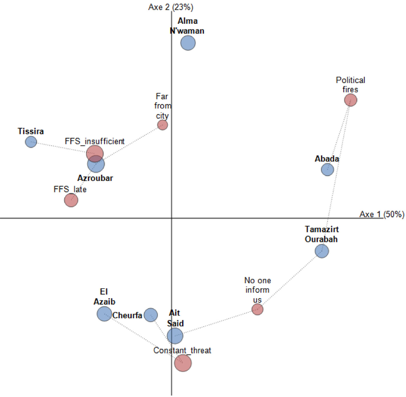
The perception of fires as a threat is rather low at only 16.1% of respondents, whereas there is larger consensus of respondents that fear fires (55.5%) or that are greatly concerned of them (28.3%). Reasons of concern are rather different, with 23.9% claiming that fire is a constant threat for them and their assets; 25.6% of respondents point out the insufficient fire fighting service provided by the Civil Protection agency, or its late intervention in case of a fire (16%), and the relatively long distances between the cities and the locations of the fires (10%), which reflects on the time of arrival and first intervention. Some respondents (13.6%, the majority from the hamlet of Abada) are concerned by political fires (to oppose terrorism - Fig. 2).
Fig. 2 - Fire concern in the different hamlets based on Factorial Correspondence Analysis (FCA). The diameter of circles is proportional to values in the contingency table, while dotted lines join the hamlets (blue circles) sharing a specific problem (red circles). For the hamlets of El Azaib, Ait Said, Cheurfa fire is a constant threat; in the hamlet of Abada there are concerns of political fires; Azrouba and Alma N’waman complain about the relative inefficiency and late arrival of Civil Protection forces, and distance from town (Chi square=156.95; df=35; p<0.01).
Information about risk
A vast majority of respondents (85%) declare their interest in receiving more information about wildfire risk, mainly under the form of meetings (39.8%), pamphlets (22.9%) and radio broadcasts (22.3%). On the contrary, daily news and television are by far the less preferred (8.2% and 6.8%, respectively).
Radio broadcasts and meetings are the most preferred means by people in the age class from 40-59 to 60-79, whereas younger respondents (age class 20-39) clearly prefer pamphlets and radio broadcasts. Meetings, which are also an occasion for socialization, are the media preferred by the oldest participants (age > 80).
Social groups confirm their scattered preference: radio attracts housewives, meetings are appreciated by the retired, newspapers are preferred by the liberal and unemployed, pamphlets by students, television by farmers and officials. Like housewives, shepherds prefer meetings.
Information source
Foresters are indicated by the vast majority of respondents (60.5%) as the preferred source of information, followed by municipalities (26%), Civil Protection and Firefighters (13.5%).
On the contrary, in case of fire the vast majority (95.7%) of respondents will call the fire service. This may just indicate that the emergency telephone number of the fire service (14) is much easier to remember than the foresters’ one, which has a non-friendly nine digits format.
Fire hazard and assets
The vast majority of respondents (69.3%) think that their homes are not exposed to the risk of fire, thus aligning to the previous 76.8% of surveyed people who perceive their hamlets well protected.
At the same time, 68.5% of respondents believe that their property (fields, livestock, olive trees, etc.) is exposed to fire risk. Assets such as fields and crops are considered the most exposed to fire risk (57.8%), followed by olive trees (26%), and livestock (16.3%). Respondents focus risk more on their productive assets than on buildings, which are probably considered safer, due to their incombustible building materials (mainly stones and bricks).
How to defend against fires
The quasi-totality of respondents (92.1%) declare to know how to defend themselves in case of fire events; in decreasing order, the tools to be utilized are water (42.4%), and hand tools (39.3% - Fig. 3). The use of backfire (i.e., a fire that burns into or against the wind, purposely set to consume fuel before the arrival of an advancing wildfire), is mentioned by only 13.9% of respondents. An even smaller number of respondents mention perimetral strips, to be ploughed up by a tractor around cultivated fields.
Fig. 3 - Measures adopted in the differents hamlets to control fires. All villages prefer the use of water and hand tools in order to control fires. El Azaib is more oriented to the use of firelines or firebreaks, whereas Alma N’waman is clearly oriented to the use of backfire. Firebreaks are clearly an outlier, arguably because it is necessary to have the tractor to plough them.
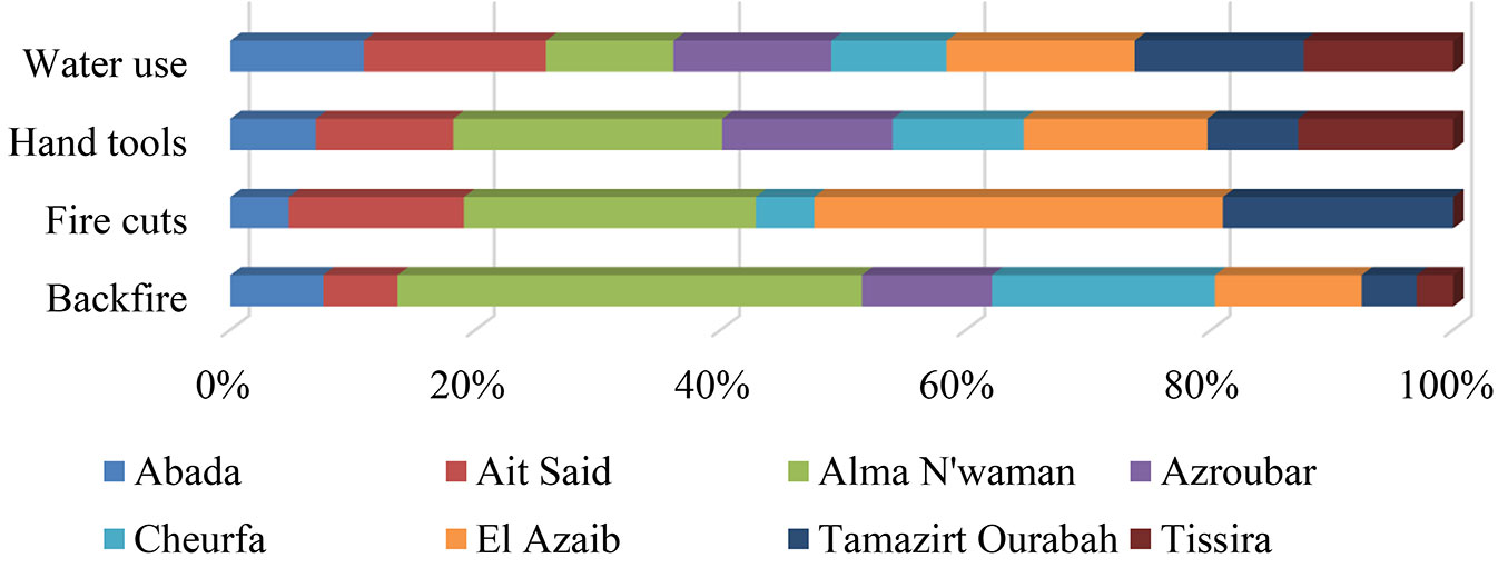
Use of water is the most preferred technique for all groups, but especially by housewives (32.2%), employees (19.3%), students (12.9%), and farmers (10.9 %).This probably depends on its use by firemen, and the popularity of images of firefighting interventions. In any case, it contrasts with the water paucity which characterizes the hamlets and the whole country, and with the lack of pumps, hoses or tractors.
The use of backfire, on the contrary, is rather equally shared by a minority of respondents, with the exception of breeders; probably, for the latter group, this technique might appear dangerous to livestock and to fodder resources. Although rather modest, this preference is probably connected to the traditional habit of using fire in land management (the keçir) “…that consisted of clearing land by setting controlled fires every four years…” ([17], pag.4).
Back-fire could be considered as a telltale sign of persistence of TEK, Traditional Ecological Knowledge ([7]), which encompasses knowledge about the environment derived from experience and traditions ([41], [24], [40]).
Prevention measures
Among the prevention measures already used by 90.6% of respondents, the majority state that they use brush clearing around houses (70%), followed by pruning trees closest to their homes (16.4%), and ploughed strips around their fields (13.6%). This latter modest value is rather significant, because the Decree 87- 44 of 10 February 1987 sets rules imposing the presence of defensive strips around all fields; the declared non-compliance with laws by about 86% of respondents contrasts the feeling of being well defended against fire.
Measures mentioned have a different efficacy: whereas brush clearing around houses, if wide enough, creates a defensible space, where fire spread could be easily stopped, pruning of trees is only efficacious to reduce the possibility that a running fire may become a crown fire, and has no effect on preventing or mitigating surface fires ([11]).
The low preference for perimetral ploughed strips, on the contrary, besides being a failure to comply with specific rules for the protection of domanial forests, is an aggravating factor of risk, since it makes easier for fires to propagate on cultivated land, so producing a disaster in a local economy grounded on subsistence.
From the perspective of the single hamlets, the preferences for prevention measures appear rather polarized along brush clearing (4 out of the 8 hamlets) and perimetral strips and pruning of trees (2 out of 8 for both), thus confirming the individual responses. This suggests that people are reluctant to fear the worst; culturally accepted precautions are considered adequate to provide protection from a risk that is badly perceived, probably because it is relatively infrequent ([3]).
Use of fire
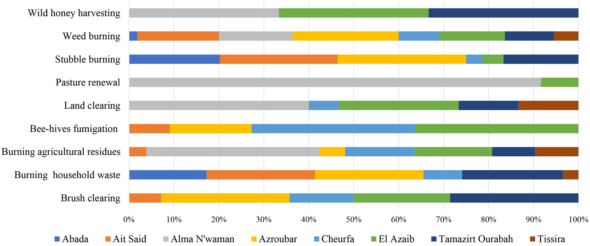
Respondents use fire as a tool for stubble burning (27.5% of respondents), burning for disposal of household waste (19%), burning of weeds and agricultural residues, with 18% and 17%, respectively. Other reasons for the use of fire (land clearing, brush clearing, renewal of ranges), received lower values (4.9%, 4.6%, 4.3%, respectively). Very low values characterize the activity of apiculture (fumigation of bee-hives) and last, restricted to only the hamlet of Tissira, the traditional use of fire for wild honey hunting (Fig. 4).
Fig. 4 - Distribution of fire use in the different hamlets. In Azroubar, Abada, Ait Said, Tamazirt Ourabah fire use appears strictly connected with stubble burning, disposal of domestic waste, and mainly for Azroubar, weed burning. Respondents from Tissira favour land clearing, burning agricultural residues, and wild honey hunting. Fumigation of bee-hives seems only restricted to Cheurfa and El Azaib, together with brush clearing. Respondents from Alma n’Waman indicate pasture renewal, land clearing, burning agriculture residues.
How respondents learned to use fire and loss of its use
The majority of respondents declare having learned to use fire from their fathers (50.8%), followed by grandfathers (30.7%) and then their mothers (14.6%). This latter response confirms the matriarchal regime of hamlets in Kabilya and the importance of women’s activity in agriculture ([21]).
For 69.2% of respondents, traditional knowledge of fire is still present, whereas for 30.8% traditional knowledge is not always there. Almost two thirds of respondents, in age classes 40 to 79, gave a positive reply to the question, and 100% of more aged respondents, age class >80, confirmed this answer.
The main cause for which traditional knowledge of fire use is lost is related to its dangerousness, with a rate of 57.5%, followed by the response that it is a tiring activity (29.5%). Younger people who have abandoned working on the land, refuse this traditional knowledge, and clearly support (62.2%) the idea that TEK is no longer present in the area.
Conclusion
The perception of the residents has been studied on the issues of wildfire risk, and the traditional use of fire. People have scarce awareness, tending to consider the phenomenon as decreasing, and illusorily perceive their hamlets to be well protected by preventive measures. The degree of concern about fire risk is moderate in Mizrana residents, with less than one third of them perceiving fire risk as a constant threat. Unapt or scarcely efficient prevention measures accompany this conviction.
Although traditional ecological knowledge in the use of fire was diffuse and qualified in the past, the survey group seems alien to this. The replies provided by the youngest underline this distance, when declaring that a motif of TEK disappearance is that it is tiring; the younger generation seems uninterested in agroforestry activities in relation to fire occurrence, and they implicitly expect protection and response from the State (Civil Protection, and Foresters) in case of a fire event. They do not blame themselves for failing to undertake adequate preventive measures and complain about the late arrival of firefighters, caused also by the distance from their headquarters.
Residents are unaware of the risks they are facing, or they are overly confident about it, and actually engage in hazardous behavior in the use of fire (for instance the disposal of domestic waste by fire is the cause of most wildfires).
Traditional prevention measures, evidenced by some respondents, are unfit to cope with a medium-high intensity fire, and the use of water as suppression agent (highly rated), further underlies a lack of awareness, as it is efficacious only on low-medium intensity fires, not on the extreme fires that often ravage the country.
Lack of awareness is also indicated by a lack of compliance with law (as is the case of the perimetral ploughed strips around fields) and, in the opposite situation, in adopting measures which have a scarce or very scarce chance of containing a fire.
More than two thirds of the surveyed population think that their houses are not exposed to fire risk, because they are built with fire-resistant materials (concrete, brick, etc).
Passing from the individual to the collective lack of suitable behavior, we underline the inherent risk of living in the forest interface, without a collective effort to make these areas better protected and safer. Living in harm’s way is accompanied by a discounting of the potential impacts of fires, so risk of loss of life or house destruction receives less attention.
Our survey indicates a lack of awareness of the inhabitants of these zones. More than just a misunderstanding of risk, respondents’ cognitive limitation could be caused by “optimism bias”: they tend to overestimate the likelihood of positive events, and underestimate the likelihood of negative events.
Notwithstanding the relevant fire presence in the history of the area, the inhabitants appear to dismiss the evidence of hazardous conditions. They are probably induced by the infrequent occurrence of extreme events, and the fading of personal memory about them, which has nurtured a dangerous overconfidence on their fire suppression capabilities. This perception will make nearly impossible to implement efficacious prevention plans, or to cope with the increasing severity and frequency of wildfires which is projected to occur as a result of climate change.
Although living in two of the more fire prone towns in the most severely fire affected wilaya of Algeria, respondents’ actions compound in the case of a wildfire disaster and aggravate potential losses, for instance unwisely using fire in severe fire weather conditions, or avoiding efficacious prevention measures.
Even though referred to a limited situation in Kabylia, this exploratory and qualitative study is the first to analyze fire risk perception in Algeria. Its findings suggest that a similar type of survey should be carried out at a wider scale, in order to explore how people really perceive fire threat, and how they behave on the ground, before mounting ambitious plans for a fire prevention program within the country.
Acknowledgments
We are very grateful to the respondents and foresters who accompanied us on the ground. We appreciate the time they dedicated to us and their remarkable attention and interest in responding to survey. We also thank the three anonymous reviewers for their insightful comments on the paper, as these comments led to an improvement of the work.
While remaining responsible for any errors in this paper, the authors would like to thank Dr. Robert Stacey, Northumberland Fire and Rescue Service, Cramlington (UK) for his patience and accessibility in reviewing the text and the numerous remarks he provided to improve it.
References
Gscholar
Gscholar
Online | Gscholar
Gscholar
CrossRef | Gscholar
Gscholar
Gscholar
CrossRef | Gscholar
Gscholar
Online | Gscholar
Gscholar
Gscholar
Gscholar
Gscholar
Gscholar
Supplementary Material
Authors’ Info
Authors’ Affiliation
Hanane Limani
Naima Rabia
Rachid Meddour
Department of Agricultural Sciences. University of Mouloud Mammeri, Box 17 RP, Tizi Ouzou 15000 (Algeria)
formerly at Department of Crop Systems, Forestry and Environmental Sciences, University of Basilicata, v.le dell’ Ateneo Lucano 10, 85100 Potenza (Italy)
Biodiversity Ecology Evolution, University of Montpellier (France)
Corresponding author
Paper Info
Citation
Sahar O, Leone V, Limani H, Rabia N, Meddour R (2018). Wildfire risk and its perception in Kabylia (Algeria). iForest 11: 367-373. - doi: 10.3832/ifor2546-011
Academic Editor
Matteo Garbarino
Paper history
Received: Jul 02, 2017
Accepted: Feb 12, 2018
First online: May 04, 2018
Publication Date: Jun 30, 2018
Publication Time: 2.70 months
Copyright Information
© SISEF - The Italian Society of Silviculture and Forest Ecology 2018
Open Access
This article is distributed under the terms of the Creative Commons Attribution-Non Commercial 4.0 International (https://creativecommons.org/licenses/by-nc/4.0/), which permits unrestricted use, distribution, and reproduction in any medium, provided you give appropriate credit to the original author(s) and the source, provide a link to the Creative Commons license, and indicate if changes were made.

Web Metrics
Breakdown by View Type
Article Usage
Total Article Views: 39333
(from publication date up to now)
Breakdown by View Type
HTML Page Views: 32200
Abstract Page Views: 2569
PDF Downloads: 3776
Citation/Reference Downloads: 6
XML Downloads: 782
Web Metrics
Days since publication: 2178
Overall contacts: 39333
Avg. contacts per week: 126.41
Article Citations
Article citations are based on data periodically collected from the Clarivate Web of Science web site
(last update: Feb 2023)
Total number of cites (since 2018): 1
Average cites per year: 0.17
Publication Metrics
by Dimensions ©
Articles citing this article
List of the papers citing this article based on CrossRef Cited-by.
Related Contents
iForest Similar Articles
Research Articles
Wildland fire typologies and extreme temperatures in NE Spain
vol. 10, pp. 9-14 (online: 01 November 2016)
Research Articles
Analysis of forest fires causes and their motivations in northern Algeria: the Delphi method
vol. 6, pp. 247-254 (online: 13 June 2013)
Research Articles
Developing wildfire risk probability models for Eucalyptus globulus stands in Portugal
vol. 6, pp. 217-227 (online: 27 May 2013)
Research Articles
Wildfires in Algeria: problems and challenges
vol. 8, pp. 818-826 (online: 25 March 2015)
Research Articles
Assessing the performance of fire danger indexes in a Mediterranean area
vol. 11, pp. 563-571 (online: 01 September 2018)
Research Articles
Harmonized dataset of surface fuels under Alpine, temperate and Mediterranean conditions in Italy. A synthesis supporting fire management
vol. 13, pp. 513-522 (online: 13 November 2020)
Research Articles
Analysis of factors influencing deployment of fire suppression resources in Spain using artificial neural networks
vol. 9, pp. 138-145 (online: 19 July 2015)
Research Articles
Post-fire effects and short-term regeneration dynamics following high-severity crown fires in a Mediterranean forest
vol. 5, pp. 93-100 (online: 30 May 2012)
Research Articles
Historical fire ecology and its effect on vegetation dynamics of the Lagunas de Montebello National Park, Chiapas, México
vol. 14, pp. 548-559 (online: 01 December 2021)
Research Articles
Post-fire recovery of Abies cephalonica forest communities: the case of Mt Parnitha National Park, Attica, Greece
vol. 11, pp. 757-764 (online: 15 November 2018)
iForest Database Search
Search By Author
Search By Keyword
Google Scholar Search
Citing Articles
Search By Author
Search By Keywords
PubMed Search
Search By Author
Search By Keyword


